Google Maps™ driving directions home » Africa maps

Eritrea

Driving Directions Eritrea

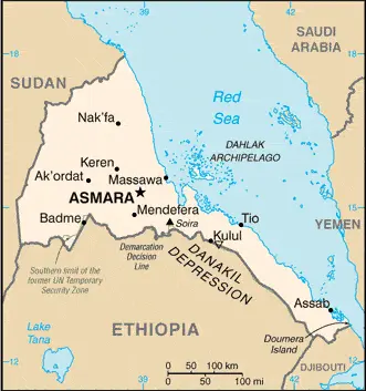
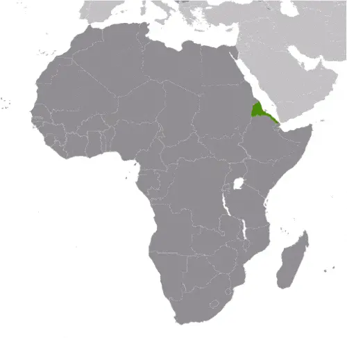
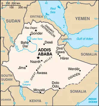
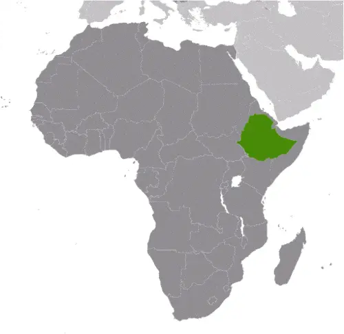
ERITREA, formerly an autonomous province of Ethiopia, gained independence in May 1993 following a long, armed struggle against Ethiopia, which had been in control since 1945. Bounded by Djibouti, Sudan, and Ethiopia, Eritrea has acquired Ethiopia’s entire coastline along the Red Sea. The small Eritrean port of Aseb, in the southeast corner of the country, has been designated a free port guaranteeing the right of access to the now landlocked Ethiopia. Eritrea has a coastal plain rising to a belt of plateaux and mountains in the center and north. West of the mountains, the ground descends to form a region of undulating plains.

Read more

Google Maps™ driving directions home » Africa maps

Eritrea Google Map

This image shows the draft map of Eritrea, Africa. For more details of the map of Eritrea, please see this page below. This image shows the location of Eritrea, Africa. For more geographical details of Eritrea, please see this page below. This image shows the flag of Eritrea, Africa. For more details of the flag of Eritrea, please see this page below.
Borderline map of Eritrea Location map of Eritrea Flag of Eritrea

Eritrea Google map

Google Maps and Detailed Facts of Eritrea (ER). This page lets you explore Eritrea and its border countries (Country Location: Eastern Africa, bordering the Red Sea, between Djibouti and Sudan) through detailed Satellite imagery – fast and easy as never before Google Maps.

Find comprehensive information about this country’s diversity below: Google maps, geography, economy, science, people, culture, environment, government, and history – All in One Wiki page.

There is also a Street View and free Driving Directions at your service. Your Google Satellite Map Sightseeing in Eritrea, in Africa, starts here at Driving Directions and Maps.com.

Read more

Google Maps™ driving directions home » Africa maps

Ethiopia

Driving Directions Ethiopia

ETHIOPIA is a landlocked, east African republic that borders Sudan, Kenya, Somalia, Djibouti, and Eritrea. Formerly known as Abyssinia, the country is dominated by a high, central plateau of volcanic rock from which rise rugged mountains ascending to heights of 4,572 meters or 15,000 feet. The Great African Rift Valley divides the plateau into the higher, more rugged, and extensive Western Highlands and the Eastern Highlands’ smaller area. The plateau is deeply dissected by river valleys forming towering cliffs and escarpments, especially in the northeast.

Read more

Google Maps™ driving directions home » Africa maps

Ethiopia Google Map

This image shows the draft map of Ethiopia, Africa. For more details of the map of Ethiopia, please see this page below. This image shows the location of Ethiopia, Africa. For more geographical details of Ethiopia, please see this page below. This image shows the flag of Ethiopia, Africa. For more details of the flag of Ethiopia, please see this page below.
Borderline map of Ethiopia Location map of Ethiopia Flag of Ethiopia

Ethiopia Google map

Google Maps and Detailed Facts of Ethiopia (ET). This page lets you explore Ethiopia and its border countries (Country Location: Eastern Africa, west of Somalia) through detailed Satellite imagery – fast and easy as never before Google Maps.

Find comprehensive information about this country’s diversity below: Google maps, geography, economy, science, people, culture, environment, government, and history – All in One Wiki page.

There is also a Street View and free Driving Directions at your service. Your Google Satellite Map Sightseeing in Ethiopia, in Africa, starts here at Driving Directions and Maps.com.

Read more

Google Maps™ driving directions home » Africa maps

Freetown Google maps

Freetown is one of the most populated cities in Sierra Leone, and at the same time, this city is the capital of this country. Located in Africa, you may find the city easily with the following GPS coordinates: 08.30N latitude / 13.17W longitude. For routing in Freetown, please check the free driving directions Freetown service below.

Read more

Google Maps™ driving directions home » Africa maps

Gabon

Driving Directions Gabon

GABON is a small republic in west-central Africa that straddles the Equator. It comprises the land which surrounds the Ogooué river basin and its tributaries, and most of the country covered with lush tropical rainforests.

Beyond the coastal plain and the flatter land of the valley bot­toms, Gabon is ringed by upland plateaux and mountains ranging in height from 900-1,575 meters or 3,000-5,167 feet.

The forests con­tain a huge diversity of plants and animals, including commercially valu­able trees harvested for export. It was at Lambarene in east Gabon that Albert Schweitzer, the medical missionary, had his hospital.

Read more

Google Maps™ driving directions home » Africa maps

Gabon Google Map

This image shows the draft map of Gabon, Africa. For more details of the map of Gabon, please see this page below. This image shows the location of Gabon, Africa. For more geographical details of Gabon, please see this page below. This image shows the flag of Gabon, Africa. For more details of the flag of Gabon, please see this page below.
Borderline map of Gabon Location map of Gabon Flag of Gabon

Gabon Google map

Google Maps and Detailed Facts of Gabon (GA). This page lets you explore Gabon and its border countries (Country Location: Central Africa, bordering the Atlantic Ocean at the Equator, between Republic of the Congo and Equatorial Guinea) through detailed Satellite imagery – fast and easy as never before Google Maps.

Find comprehensive information about this country’s diversity below: Google maps, geography, economy, science, people, culture, environment, government, and history – All in One Wiki page.

There is also a Street View and free Driving Directions at your service. Your Google Satellite Map Sightseeing in Gabon, in Africa, starts here at Driving Directions and Maps.com.

Read more

Google Maps™ driving directions home » Africa maps

Gaborone Google maps

Gaborone is one of the most populated cities in Botswana, and at the same time, this city is the capital of this country. Located in Africa, you may find the city easily with the following GPS coordinates: 24.45S latitude / 25.57E longitude. For routing in Gaborone, please check the free driving directions Gaborone service below.

Read more

Google Maps™ driving directions home » Africa maps

Gambia

Driving Directions Gambia

GAMBIA is the smallest country in Africa. The Republic of the Gambia comprises a small finger of land, pushing eastwards into Senegal from the Atlantic coast in a narrow band along either side of the Gambia River.

The republic is enclosed on all its landward sides by the territory of Senegal. It mostly does not exceed 24 kilometers or 15 miles in width, only broadening to 48 kilometers or 30 miles in the east. The country is divided along its entire length by the River Gambia, which can only be crossed at two main ferry crossings.

The country consists of the river and the low plateau through which it flows interspersed with a few small, flattened hills.

Read more

Google Maps™ driving directions home » Africa maps

Ghana

Driving Directions Ghana

GHANA is located on the southern coast of West Africa between Cote d’Ivoire and Togo. In 1957, as the former British Gold Coast, it became the first black African state to achieve independence from European colo­nial rule.

The country has palm-fringed beaches of white sand along the Gulf of Guinea, and where the great River Volta meets the sea, there are peaceful blue lagoons. A coastal, grassy plain gives way to a dense jungle in the southwest and savannah country and woodland in the interior and north.

There is a range of modest-sized mountains (up to 900 meters or 2,950 feet) along the eastern border with Togo. The landscape becomes harsh and barren near the border with Burkina Faso in the far north. Forested areas have been greatly reduced and cleared during the 20th century, although some efforts were made to halt this process.

Read more