
 |
 |
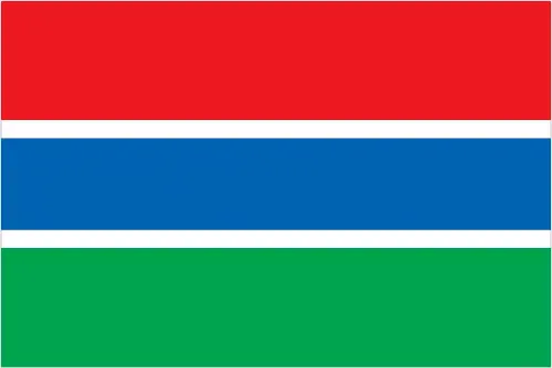 |
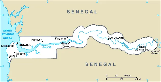
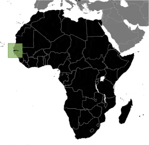
| Borderline map of Gambia | Location map of the Gambia | Flag of the Gambia |
Google Maps and Detailed Facts of the Gambia (GM). This page lets you explore the Gambia and its border countries (Country Location: Western Africa, bordering the North Atlantic Ocean and Senegal) through detailed Satellite imagery – fast and easy as never before Google Maps.
Find comprehensive information about this country’s diversity below: Google Maps, geography, economy, science, people, culture, environment, government, and history – All in One Wiki page.
There is also a Street View and free Driving Directions at your service. Your Google Satellite Map Sightseeing in the Gambia, in Africa, starts here at Driving Directions and Maps.com.
The Gambia Google Maps & Satellite Maps
The map below shows the Gambia with its cities, towns, highways, main roads, streets, and Street Views. To find a location, use the form below, type any city or place, view a simple map, and click the “show map” button.
The Google Maps above shows the Gambia with its location: Africa (geographic coordinates: 13 28 N, 16 34 W) and the international borders of Gambia; total: 749 km. Border countries (total: 1): Senegal 749 km; furthermore, it’s inland counties boundaries.
Hint: Look at the Street view in Gambia, or Africa. All you have to do is drag and pull the little yellow man (named: Pegman) on the Google Maps above the desired location. After that, whenever it is available (more than 50 countries globally), blue stripes will appear to show the photos and details from Google’s regularly updated data image base. In case if you have signed in to your Google account currently, you may have a look at the satellite map of this country/area as well.
The map of the Gambia, Africa, is for informational use only. No representation is made or warrantied given any map or its content by Driving Directions and Maps site. The user assumes all risks of using this Gambia Google Maps and facts/wiki.
About the Gambia in detail
Where is the Gambia?
The Gambia, in case, if you are looking on the map under the Coordinates 13 27 N 16 34 W otherwise in Africa, in Western Africa, bordering the North Atlantic Ocean and Senegal.
What is the capital city of the Gambia?
The capital city of the Gambia is Banjul.
What is the time in Banjul?
It is 5 hours ahead of Washington, D.C. during Standard Time; Banjul’s timezone is UTC 0.
What is the Internet code for The Gambia?
The Top Level Domain (TLD) for the Gambia is: .gm
What is the size of the Gambia?
The territory of the Gambia is total: 11,300 sq km; land: 10,120 sq km, water: 1,180 sq km.
If we want to describe the size of the Gambia territory, it is slightly less than twice the size of Delaware.
If we would like to walk around and discover the Gambia, we can cover a total distance: 749 km.
What is the water coverage of the Gambia?
We have already mentioned what percentage of the Gambia is covered by water (see below), including an 80 km coastline.
What is the climate like in The Gambia?
The climate of the Gambia is tropical: hot, rainy season (June to November): cooler, dry season (November to May).
Geographical data of the Gambia
The Gambia; mean elevation: 34 m, elevation extremes; lowest point: Atlantic Ocean 0 m, highest point: unnamed elevation 53 m.
The Gambia’s specific geographical details include the Gambia River’s flood plain flanked by some low hills.
Suppose we would like to describe the countries location from a different perspective. In that case, it is safe to say, and easy to read from a map, the Gambia is almost an enclave of Senegal, the smallest country in Africa.
Resources and land use of the Gambia
The country’s main mined products are fish, clay, silica sand, titanium (rutile and ilmenite), tin, zircon. The population partly uses the earlier highlighted land territory and partly left in its natural state: agricultural land: 56.1%; arable land 41%; permanent crops 0.5%; permanent pasture 14.6%; forest: 43.9%; other: 0% (2011 estimate).
Population data of the Gambia
The number of inhabitants of the Gambia is 2,009,648 (July 2016 estimate).
If we examine the proportion of the population distribution, it is safe to say that N/A.
If we look at the proportion of the urbanized and barely populated areas, these are the figures: urban population: 59.6% of the total population (2015).
Most of the population in the Gambia is concentrated in BANJUL (capital) 504,000 (2015).
Ethnicity in the Gambia
According to ethnicity details, the ethnic groups are Mandinka/Jahanka 33.8%, Fulani/Tukulur/Lorobo 22.1%, Wollof 12.2%, Jola/Karoninka 10.9%, Serahuleh 7%, Serere 3.2%, Manjago 2.1%, Bambara 1%, Creole/Aku Marabout 0.8%, other 0.9%, non-Gambian 5.2%, no answer 0.7% (2013 estimate).
Spoken languages in the Gambia
The Gambia’s spoken languages are the following: English (official language), Mandinka, Wolof, Fula, other indigenous vernaculars.
What are the most important religions in the Gambia?
During the general census, researchers examine the churches, according to this: Muslim 95.7%, Christian 4.2%, none 0.1%, no answer 0.1% (2013 estimate).
Further population data of the Gambia
The proportion of gender and age tells a lot about the society as follows 0-14 years: 37.88% (male 382,215 / female 379,029) 15-24 years: 20.64% (male 204,979 / female 209,866) 25-54 years: 33.92% (male 333,875 / female 347,779) 55-64 years: 4.14% (male 39,978 / female 43,177) 65 years and over: 3.42% (male 32,011 / female 36,739) (2016 estimate). It also a significant factor in a society the population growth rate, which in the case of the Gambia is 2.11% (2016 estimate).
The population growth rate is based on two elements, the birth, and the death rate. In the Gambia the birth rate is 30.1 births / 1,000 population (2016 estimate), the death rate 7.1 deaths / 1,000 population (2016 estimate).
In this day and age in developed societies, the first child borns later compared to the previous centuries and decades, so childbearing is extended. In the Gambia, the average age of mothers at the first childbirth is N/A.
Although the children’s birth is postponed in the best-case scenario, the parents can still see their kids grow as life expectancy also extended. In the case of the Gambia, these figures are. With the introduction of modern medicine, vaccinations, and the proper hygienic conditions, the infant mortality rate is in a steep decline. The infant mortality statistics in the Gambia are the following: N/A. Relevant data is the budget of healthcare, which is in the case of this country is 7.3% of GDP (2014).
Economic data of Gambia
Suppose we would like to describe a country. We also have to mention its economy; The government has invested strongly in the agriculture sector because three-quarters of the population depends on its livelihood, and agriculture provides for another one-fifth of GDP. The agricultural sector has untapped potential. The Gambia has sparse natural resource deposits and a limited agricultural base. It relies heavily on remittances from workers overseas and tourist receipts—remittance inflows to The the Gambia amount to about one-fifth of the country’s GDP. Economic progress depends on sustained bilateral and multilateral aid, responsible government financial management, and continued technical assistance from multilateral and bilateral donors. International donors and lenders continue to be concerned.
GDP is a prominent figure, as all the relevant calculations and statistics are based on it. GDP in the Gambia is $886 million (2015 estimate).
Another important indicator is the rate of GDP growth, which in the Gambia is 2.3% (2016 estimate) 4.4% (2015 estimate) -0.2% (2014 estimate).
These statistics affect the world economy; remember, in 2015, the Chinese real GDP growth rate was worse than expected; The world markets fall, and the Chinese stock exchange was temporally suspended.
A further major factor of a country’s economy, the GDP per capita. In the Gambia this is $1,700 (2016 estimate) $1,700 (2015 estimate) $1,600 (2014 estimate).
In the economy, the Trinity is in common places, such as agriculture, industry, and services.
What are the agricultural products the Gambia produces?
The Gambia’s main agricultural products are rice, millet, sorghum, peanuts, corn, sesame, cassava (manioc, tapioca), palm kernels; cattle, sheep, goats.
The essential segments are peanuts, fish, hides, tourism, beverages, agricultural machinery assembly, woodworking, metalworking, and clothing. The crucial and regularly mentioned GDP is based on peanuts, fish, hides, tourism, beverages, agricultural machinery assembly, woodworking, metalworking, clothing.
Drinking water source in the Gambia
It is essential to mention that – thanks to the development of the infrastructure -, the rate of potable water improved: urban: 94.2% of the population, rural: 84.4% of the people, total: 90.2% of the community. Unimproved: urban: 5.8% of the people, rural: 15.6% of the population, total: 9.8% of the population (2015 estimate).
The average number of childbirth in the Gambia
In the Gambia, the average delivery number is 3.63 children born / woman (2016 estimate).
Population, median age, migration, and citizenship in the Gambia
The population’s average age is 20.7 years; male: 20.4 years, female: 21 years (2016 estimate). The age of adulthood varies in every country of the world in the Gambia; it is 18 years of age, universal.
When we are experiencing an unprecedented scale of migration and globalization, it is an important factor in the number of new immigrants. In the Gambia is -2 migrant(s) / 1,000 population (2016 estimate). It is important to know how to apply for citizenship: citizenship by birth: yes. Citizenship by descent: yes. Dual citizenship recognized: no—residency requirement for naturalization: 5 years.
Is the Gambia a safe destination? Healthcare services and infectious diseases in the Gambia
Many of the travelers are looking into the healthcare services and infectious diseases of their destinations. In the Gambia, the hospital beds’ density is 1.1 beds / 1,000 population (2011).
According to the WHO rating regarding contagious diseases in the Gambia, the degree of risk: very high food or waterborne diseases: bacterial and protozoal diarrhea, hepatitis A, and typhoid fever vectorborne diseases: malaria and dengue fever water contact disease: schistosomiasis respiratory disease: meningococcal meningitis animal contact disease: rabies (2016).
However, HIV is not curable but maintainable. Let’s do not forget when the disease surfaced; it was a world threatening condition. Unfortunately, in some countries, it is still very high the number of infected patients and fatalities due to the disease.
In the Gambia, the number of HIV/AIDS deaths: N/A.
Regarding tourism obesity, not an important issue, but we have to mention health statistics, as it is the plague of the 20th and the 21st century. The rate of obese adults in the Gambia is 9.1% (2014).
What are the natural hazards in the Gambia? Is there any?
The most known natural risk in the Gambia is drought (rainfall has dropped by 30% in the last 30 years).
More interesting facts about the Gambia
Like every country and society, a few words about the past are connected to its history; the Gambia gained its independence from the UK in 1965. Geographically surrounded by Senegal, it formed a short-lived Confederation of Senegambia between 1982 and 1989. In 1991 the two nations signed a friendship and cooperation treaty, but tensions have flared up intermittently since then. Yahya JAMMEH led a military coup in 1994 that overthrew the president and banned political activity. A new constitution and presidential election in 1996, followed by parliamentary balloting in 1997, completed a nominal return to civilian rule. JAMMEH was elected president in all subsequent elections, including most recently in late 2011. A presidential election is scheduled for December 2016.
In every nation’s memory, some cornerstones placed the country on the timeline of history. The Declaration of Independence of the Gambia: 18 February 1965 (from the United Kingdom).
The flag and other symbols of the Gambia
The colors, symbols, and animals on the flag usually have a historical background or an important milestone or memory of the nation.
This case is not an exception either; three equal horizontal bands of red (top), blue with white edges, and green; red stands for the sun and the savannah, blue represents the Gambia River, and green symbolizes forests and agriculture; the white stripes denote unity and peace.
Apart from the flag, the symbol of national unity is the national anthem. The anthem’s primary purpose is to share the nation’s core values, endeavors, and patriotic feelings.
National symbols of the Gambia: lion; national colors: red, blue, green, white.
Constitution of the Gambia
The existence of the nation is based on the constitution. Some constitutions knew worldwide, like the U.S. Constitution that was accepted on the 17th of September 1787, in Philadelphia, the United States of America’s Constitution.
It is not related to the declaration of independence that was stolen by Nicolas Cage in the movie National Treasure 🙂
What is the legal system of the Gambia?
Most of the time, the legal system of a country is the focus of lawyers. It is a common fact that there are two main approaches in the world, “the law in books” and “the law in action.”
In the Anglo-Saxon world, the practice is the “law in action,” while in the rest of the world, the law is based on Roman law, the “law in books.”
The legal system of the Gambia is a mixed legal system of English common law, Islamic law, and customary law.
It was Aristotle who founded the Theory of 3 separations of powers. In his view, these are the council of public affairs, the magistrates, and the justice system. The age of enlightenment was the time when terminologies have defined the way we still use them. In most democratic countries, the three authorities separated from each other. In dictatorships, the rules usually interweaved in one hand.
About the Gambia’s legislative branch, we can highlight the following structures unicameral National Assembly (53 seats; 48 members directly elected in single-seat constituencies by simple majority vote and five appointed by the president; members serve 5-year terms).
About the unemployment rate, labor force, and poverty line in the Gambia
One of the major problems of the 21st-century economy is unemployment. Governments are struggling to maintain a low level of the unemployment rate. Still, as a result of automation, the cheap 3rd world labor, and the outsourcing of workflow, these attempts fail. In the Gambia, the labor force is 777,100 (2007 estimate). Please bear in mind that the population in the Gambia is total: 62 deaths / 1,000 live births; male: 67.4 deaths / 1,000 live births, female: 56.5 deaths / 1,000 live births (2016 estimate) – as we already mentioned above.
The rate of unemployment in the Gambia is N/A %.
Widely known that the gap between the rich and poor is widening on an enormous scale.
According to the 2017 shocking Oxfam report, the most affluent eight people’s fortune is equal to the wealth of the poorest half of the world’s population.
In the Gambia, the households’ income and consumption compared to the entire population: lowest 10%: 2% highest 10%: 36.9% (2003).
Another widely used indicator is the so-called GINI index, which measures the inequalities of statistical dispersion, but is mainly used for measuring the sharing of income and fortune.
The GINI index was named after its founder Corrado Gini, an Italian economist. Gini index has grades between 0-1, but often it is used on a percentage basis. It is 0 if the examined criteria territorial distribution is equal. It is one of the criteria concentrated on the territory. In the Gambia, the GINI index is .50,2 (1998).
The states usually set up a poverty line, which is more or less, is a subjective measure. It varies by country; its base is often the minimum pension, the incomes of the most deficient 20 percent, the X percent of income per capita Etc.
In the Gambia, the poverty line people are the lowest 10%: 2% highest 10%: 36.9% (2003).
About the budget and central governments debt of the Gambia
The available budget mainly defines the state’s economy. The Gambia budget is; revenues: $231.5 million, expenditures: $323.6 million (2016 estimate). Taxes and other revenues are 26.1% of GDP (2016 estimate).
The budget deficit (Budget surplus (+) or deficit (-)) is N/A.
The fiscal year in The Gambia is the calendar year.
In the country’s economy, we have to consider the public debt. Public debt is the consolidated sum of the state’s local, federal, and central government debt.
Inflation rate and prime lending rate in the Gambia
A few further interesting and relevant economic data are the following; Inflation rate: 7.4% (2016 estimate), 6.9% (2015 estimate), and the rate of the Commercial bank prime lending rate: 30.6% (31 December 2016 estimate).
Export/import partners and data of the Gambia
The Gambia, with the export of products, industrial tools, and other services, generates revenue. The Gambia export value is $120 million (2016 estimate), $113.2 million (2015 estimate). The total revenue of these activities: peanut products, fish, cotton lint, palm kernels.
The most important export partners of the Gambia are China, 47.6%, India, 27.2%, France, 5.9%, the United Kingdom, 4.9% (2015).
The most important imported products are foodstuffs, manufactures, fuel, machinery, transport equipment, and the countries from where the import is coming: China 34.2%, Brazil 8.1%, Senegal 6.9%, India 5.7%, Netherlands 4.8% (2015).
Renewable energies used in the Gambia
To suppress the pollution of the environment, renewable energies have to replace the fossil energy. The more the proportion of renewable energies in a country means more effort against pollution. The Gambia, the indicator of how much of the country’s produced energy is coming from the hydroelectric source, is 0% of total installed capacity (2012 estimate).
To indicate how much another renewable energy produced is 0% of total installed capacity (2012 estimate).
Telecommunication data of the Gambia, calling code
To maintain the economy, the development of a reliable and modern telecommunications infrastructure is crucial. We can say the Gambia; good microwave radio relay and open-wire network; state-owned Gambia Telecommunications partially privatized in 2007. Domestic: combined fixed-line and mobile-cellular teledensity, aided by multiple mobile-cellular providers, is roughly 130 per 100 persons. International: country code – 220; microwave radio relay links to Senegal and Guinea–Bissau; a landing station for the Africa Coast to Europe (ACE) undersea fiber-optic cable completed in 2011 and launched in 2012; satellite earth station – 1 Intelsat (Atlantic Ocean) (2015).
Transport infrastructure in the Gambia
In the 21st century, we often say that the world has become small and there are no distances anymore. With widespread air travel when (sometimes) there are no visa restrictions, it is easy to reach other countries, but if the distance is not too long, we can also use railway or water transportation.
The number of airports in the Gambia: 1 (2013), and the number of heliports: N/A.
The total length of the roadways in the Gambia: total: 3,740 km, paved: 711 km, unpaved: 3,029 km (2011).
The total length of the waterways in the Gambia: 390 km (on River the Gambia; small oceangoing vessels can reach 190 km) (2010).
Are you traveling to The Gambia?
If you plan to travel by plane to the Gambia, try our air ticket comparison site, where you can choose from hundreds of carriers and offers. Our application is scanning the market and shows you the best and the cheapest deals without any extra charge or commission.
Are you looking for a hotel, apartment another kind of accommodation in the Gambia, Africa? We are here to help you to find your accommodation from budget to luxury. Our search engine is scanning, regularly updating data from hundreds of accommodation websites and more than a million offers. You can quickly and easily find your hotel stay anywhere in the world, without any extra charge or commission.
Facts & data about the Gambia
Name of the country: conventional long way: Republic of The the Gambia, traditional short form: The the Gambia, etymology: named for the Gambia River that flows through the country’s heart.
| Abbreviation: the Gambia | Geographic coordinates: 13 28 N, 16 34 W |
Country Location: Africa |
| Capital of the Gambia: Banjul | GPS of the Capital: 13 27 N 16 34 W |
Position: Western Africa, bordering the North Atlantic Ocean and Senegal |
| Land area: total: 11,300 sq km; land: 10,120 sq km, water: 1,180 sq km | Terrain: flood plain of the the Gambia River flanked by some low hills |
Area comparative: slightly less than twice the size of Delaware |
| Population: 2,009,648 (July 2016 estimate) | Population grow rate: 2.11% (2016 estimate) | Sex ratio: at birth: 1.03 male(s) / female, 0-14 years: 1.01 male(s) / female, 15-24 years: 0.98 male(s) / female, 25-54 years: 0.96 male(s) / female, 55-64 years: 0.93 male(s) / female, 65 years and over: 0.88 male(s) / female, total population: 0.98 male(s) / female (2016 estimate) |
| Exports: $120 million (2016 estimate), $113.2 million (2015 estimate) | Imports: $363.9 million (2016 estimate), $365.1 million (2015 estimate) | Import partners: China 34.2%, Brazil 8.1%, Senegal 6.9%, India 5.7%, Netherlands 4.8% (2015) |
| Urbanization: urban population: 59.6% of the total population (2015) | Major urban area(s): BANJUL (capital) 504,000 (2015) | Median age: total: 20.7 years; male: 20.4 years, female: 21 years (2016 estimate) |
| Internet users: total: 337,000. Percent of the population: 17.1% (July 2015 estimate) | Telephones (fixed-lines): total subscriptions: 45,000. Subscriptions per 100 inhabitants: 2 (July 2015 estimate) | Telephones (mobile, cellular): total: 2.586 million. Subscriptions per 100 inhabitants: 131 (July 2015 estimate) |
| Unemployment rate: N/A % | Nationality: the Gambian(s) adjective: the Gambian | National holidays: Independence Day, 18 February (1965) |
| Life expectancy at birth: total population: 64.9 years. Male: 62.5 years, female: 67.3 years (2016 estimate) | Total fertility rate: 3.63 children born / woman (2016 estimate) | Birthrate: 30.1 births / 1,000 population (2016 estimate) |
| Literacy: age 15 and over can read and write. Total population: 55.5%; male: 63.9%, female: 47.6% (2015 estimate) | Legal system: mixed legal system of English common law, Islamic law, and customary law | Suffrage: 18 years of age, universal |
| Industries: peanuts, fish, hides, tourism, beverages, agricultural machinery assembly, woodworking, metalworking, clothing | Industrial production growth rate: 1.2% (2016 estimate) | GDP real growth rate: 2.3% (2016 estimate) 4.4% (2015 estimate) -0.2% (2014 estimate) |
Do you like this the Gambia Google Maps & country information page?
Please do us a favor: Share or like this page using the icons at the top of the page. We also do encourage you to visit our Facebook page for more travel and country related information.
Many thanks for visiting and sharing this map & country information site!