
Google Maps and Detailed Facts of Algeria (DZ). This page lets you explore Algeria and its border countries (Country Location: Northern Africa, bordering the Mediterranean Sea, between Morocco and Tunisia) through detailed Satellite imagery – fast and easy as never before Google Maps.
Find comprehensive information about this country’s diversity below: Google Maps, geography, economy, science, people, culture, environment, government, and history – All in One Wiki page.
There is also a Street View and free Driving Directions at your service. Your Google Satellite Map Sightseeing in Algeria, in Africa, starts here at Driving Directions and Maps.com.
About Algeria in detail
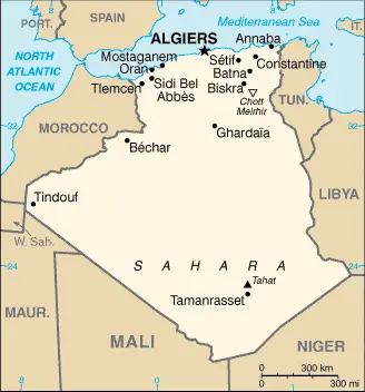
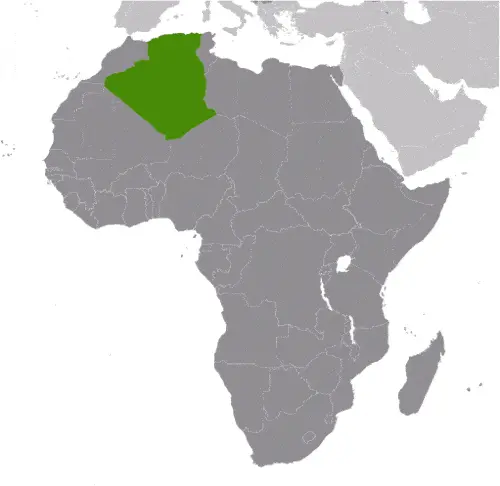
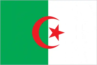
Table of contents
- Background
- Overview
- Google Maps
- Climate
- Geography
- Resources and Land Use
- Population Data
- Economic Data
- Drinking Water Source
- Population, Median Age, Migration, and Citizenship
- Average Number of Childbirths
- Is this country a Safe Destination?
- Healthcare and Infectious Diseases
- Natural Hazards
- The Flag and Other Symbols
- Constitution
- Legal System
- About the Unemployment Rate, Labor Force, and Poverty Line
- About the Budget and Central Government Debt
- Inflation Rate and Prime Lending Rate
- Export/Import Partners and Data
- Renewable Energies Used
- Telecommunication Data, Calling Code
- Transport Infrastructure
- More Interesting Facts
Background
Algeria’s history is shaped by various empires and dynasties, including the Numidians, Phoenicians, Carthaginians, Romans, Vandals, Byzantines, Arabs, Berbers, Spaniards, Ottoman Turks, and the French. After a prolonged struggle for independence, Algeria finally gained freedom from French colonial rule in 1962. This North African nation has experienced political shifts, with the National Liberation Front (FLN) playing a significant role since the independence movement. The country transitioned to a multi-party system in 1988, followed by civil unrest and eventual stabilization. Algeria has navigated through various political and economic challenges, including dependency on hydrocarbon revenues and the need for diversification.
Overview
Algeria, the largest country in Africa, is a presidential republic. The economy, primarily reliant on oil and gas, has grappled with political instability, lack of market diversification, and global economic fluctuations. Despite these challenges, Algeria has been working towards socio-economic reforms and diversification.
Official Name: People’s Democratic Republic of Algeria
Date of Formation: Independence on 5 July 1962 (from France)
Capital: Algiers. The name derives from the Arabic “al-Jazair,” meaning “the islands,” referring to the four islands formerly off the coast but joined to the mainland in 1525.
Population: Approximately 44,758,398 (2023 estimate)
Total Area: 2,381,740 square kilometers (919,595 square miles). This size is slightly less than 3.5 times the size of Texas.
Population Density: Approximately 18.8 per square kilometer (48.7 per square mile)
Languages: Arabic (official), French (lingua franca), Berber or Tamazight (official); dialects include Kabyle Berber (Taqbaylit), Shawiya Berber (Tacawit), Mzab Berber, Tuareg Berber (Tamahaq).
Religions: Muslim (official; predominantly Sunni) 99% of other religions include Christian, Jewish, Ahmadi Muslim, Shia Muslim, and Ibadi.
Ethnic Origin: Arab-Berber 99%, European less than 1%.
Government: Presidential republic.
Currency: Algerian Dinar (DZD)
Literacy Rate: Total population: 81.4%, Male: 87.4%, Female: 75.3% (2018).
Calorie Consumption: Data not specified in the provided document.
Algeria Google Maps
Algeria’s vast expanse, bordering the Mediterranean Sea and encompassing a significant portion of the Sahara Desert, can be explored through Google Maps. This tool offers detailed insights into the country’s topography, urban centers, and infrastructure, highlighting its diverse geography from coastal areas to desert landscapes.
Algeria is now Africa’s largest country on the Mediterranean coast and has been independent from France since 1962. Its regime used the army to keep Islamists from power in 1992. 85% of the country lies within the Sahara Desert. The fertile coastal region with plains and hills rises to meet the Atlas Mountains.
The map below shows Algeria’s cities, towns, highways, main roads, streets, and Street Views. To find a location, use the form below, type any city or place, view a simple map, and click the “show map” button.
The Google Maps above shows Algeria’s location: Africa (geographic coordinates: 28 00 N, 3 00 E) and the international borders of Algeria; total: 6,734 km. Border countries (total: 7): Libya 989 km, Mali 1,359 km, Mauritania 460 km, Morocco 1,900 km, Niger 951 km, Tunisia 1,034 km, Western Sahara 41 km; furthermore, it’s inland counties boundaries.
The map of Algeria, Africa, is for informational use only. No representation is made or warrantied given any map or its content by Driving Directions and Maps site. The user assumes all risks of using this Algeria Google Maps and facts/wiki.
Climate
Algeria’s climate, characterized by its significant variation across different regions, reflects the country’s diverse geography, which includes the Mediterranean coast, high plateaus, and the vast expanse of the Sahara Desert. Here’s an extended overview of Algeria’s climatic conditions, incorporating factual and interesting aspects:
- Mediterranean Coastal Climate: Along the Mediterranean coast, which includes cities like Algiers and Oran, the climate is typically Mediterranean. This region experiences mild, wet winters with average temperatures ranging from 10°C to 12°C (50°F to 54°F). Summers are hot and dry, with temperatures often exceeding 30°C (86°F).
- High Plateaus Climate: The high plateaus between the coastal region and the Sahara Desert experience more extreme climatic conditions. This area has colder winters and hotter summers compared to the coast. Winter temperatures can drop below freezing, and snowfall is not uncommon. Summer temperatures can reach up to 40°C (104°F).
- Sahara Desert Climate: The Sahara Desert, which covers a significant portion of Algeria, has one of the most extreme climates in the world. This region is characterized by very low annual rainfall, often less than 50 mm (2 inches). Daytime temperatures in the summer can be scorching, exceeding 50°C (122°F), while night temperatures can drop significantly, sometimes approaching freezing.
- Temperature Variations: The temperature variations in the Sahara Desert are among the most extreme on the planet. The difference between day and night temperatures can be as much as 30°C to 40°C (54°F to 72°F).
- Rainfall Patterns: Rainfall in Algeria varies significantly from north to south. The coastal region receives most of the country’s rainfall, averaging between 400 to 670 mm (15.7 to 26.4 inches) annually. In contrast, the Sahara Desert is one of the driest places on Earth.
- Sirocco Winds: Algeria experiences the hot, dry Sirocco winds, known locally as “Chehili”. Originating from the Sahara, these winds can cause sudden temperature increases and are known for carrying sand and dust, reducing visibility and impacting air quality.
- Climate Change Impact: Like many countries, Algeria faces challenges due to climate change. Increasing temperatures, changing precipitation patterns, and more frequent extreme weather events are expected to impact water resources, agriculture, and biodiversity.
- Microclimates: Due to its varied topography, Algeria has several microclimates. For instance, the mountainous Kabylie region in the north has a cooler, more temperate climate than the surrounding areas.
- Agricultural Impacts: The climatic variation across Algeria influences agricultural practices. The coastal regions, with their milder climate and higher rainfall, are suitable for growing various crops, including olives, citrus fruits, and vegetables. In contrast, the arid and semiarid regions focus on pastoralism and drought-resistant crops.
- Oases in the Sahara: Oases form unique microclimates that support life in the harsh desert environment. These areas, where groundwater reaches the surface, allow for cultivating date palms and other crops and are vital for local communities.
Algeria’s climate, with its stark contrasts from the Mediterranean coast to the Sahara Desert, significantly shapes the country’s natural landscapes, biodiversity, and socio-economic activities. Understanding these climatic conditions is crucial for environmental planning, sustainable development, and adapting to the challenges posed by climate change.
Geography
Algeria’s geography, characterized by its vast expanse of the Sahara Desert, high plateaus, and significant mountain ranges, presents a diverse and dramatic landscape. Here’s an extended overview of Algeria’s geographical features, including more detailed statistics and information about its neighboring countries:
- Sahara Desert: Covering more than 80% of Algeria’s land area, the Sahara Desert is the dominant geographical feature. This vast desert landscape is characterized by sand dunes (ergs), rocky plateaus (hamadas), and occasional mountain ranges. The Sahara in Algeria is not just barren sand; it also includes oases and dry valleys (wadis).
- High Plateaus: The high plateaus, or ‘Hauts Plateaux’, run parallel to the coast, between the Atlas Mountains and the Sahara Desert. This region features steppe-like plains at an elevation of 1,000 to 1,500 meters (3,280 to 4,920 feet), and is characterized by semi-arid climate conditions.
- Atlas Mountains: In the north, the Atlas Mountains, including the Tell Atlas and the Saharan Atlas, stretch across the country. These mountains are crucial in creating the varied climatic zones in Algeria and are home to a significant portion of the country’s biodiversity.
- Hoggar Mountains: In the south, the Hoggar (Ahaggar) Mountains rise from the heart of the Sahara Desert. This mountainous region, centered around the city of Tamanrasset, is known for its stunning lunar landscapes and ancient volcanic rocks.
- Highest Point – Tahat: Mount Tahat, at 2,908 meters (9,541 feet), is the highest point in Algeria. Located in the Hoggar Mountains, it is a geologically fascinating region with ancient volcanic structures and rugged terrain.
- Lowest Point – Chott Melrhir: Chott Melrhir, at -40 meters (-131 feet), is the lowest point in Algeria. It is a large endorheic salt lake in the Sahara, and its size varies seasonally. Salt flats and arid landscapes characterize the area around Chott Melrhir.
- Mean Elevation: The mean elevation of Algeria is about 800 meters (2,625 feet), reflecting the country’s overall high terrain, dominated by the Sahara and high plateaus.
- Surrounding Countries:
- Tunisia: To the northeast, Algeria shares a border with Tunisia. This boundary, approximately 1,034 kilometers (642 miles) long, includes stretches of the Tell Atlas Mountains and semi-arid regions.
- Libya: To the east, Algeria’s border with Libya extends for about 982 kilometers (610 miles). This border primarily cuts across the Sahara Desert, featuring arid and harsh landscapes.
- Niger: To the southeast, Algeria and Niger share a border of about 951 kilometers (591 miles), traversing some of the most remote parts of the Sahara.
- Mali: To the south, the border with Mali is approximately 1,376 kilometers (855 miles) long, also running through the Sahara Desert.
- Mauritania: To the southwest, Algeria’s border with Mauritania is around 463 kilometers (288 miles), encompassing desert landscapes.
- Western Sahara: To the west, Algeria has a border with the disputed territory of Western Sahara, which is about 41 kilometers (25 miles) long.
- Morocco: To the northwest, the border with Morocco stretches for about 1,559 kilometers (969 miles), running through the Atlas Mountains and the Mediterranean coastal plains.
Coastline: Algeria has a Mediterranean coastline that extends for about 1,622 kilometers (1,008 miles). This coastline features a mix of sandy beaches, rocky cliffs, and several important ports like Algiers and Oran.
Natural Resources: Algeria is rich in natural resources, particularly hydrocarbons. It is one of the largest oil producers in Africa and has significant reserves of natural gas and oil.
Algeria’s diverse geography, from the Mediterranean coast to the heart of the Sahara, defines its natural beauty and ecological richness and influences its cultural and historical development. The country’s terrain and its position in North Africa make it a unique and varied geographical entity.
Resources and Land Use
Algeria has natural resources like petroleum, natural gas, iron ore, phosphates, uranium, lead, and zinc. The land use is predominantly agricultural, with 17.4% of the land used for agricultural purposes, including 3.2% arable land.
Population Data
As of 2023, Algeria’s population is approximately 44.8 million, with a significant concentration in the northern part of the country along the Mediterranean coast.
Economic Data
The Algerian economy relies heavily on hydrocarbon, with a real GDP of $487.716 billion (estimated for 2021). The country faces challenges in diversifying its economy and has been affected by global oil price fluctuations.
Drinking Water Source
Algeria has significantly improved its water supply, with 99.4% of the population accessing improved drinking water sources.
Population, Median Age, Migration, and Citizenship
The median age in Algeria is 28.9 years, and the country experiences a moderate population growth rate of 1.62% (estimated for 2023). Algeria has a relatively low net migration rate.
Average Number of Childbirths
The average number of childbirths per woman in Algeria is 2.97 children (estimated to be 2023).
Is this country a Safe Destination?
Algeria is generally safe for travelers, though certain areas may pose risks, particularly near borders and remote regions. It’s advisable for visitors to stay informed about regional advisories.
Healthcare and Infectious Diseases
Algeria has been investing in its healthcare system, which is reflected in its current health expenditure of 6.3% of GDP (2020). The country has a physician density of 1.72 physicians/1,000 population (2018).
Natural Hazards
The country is prone to severe earthquakes, especially in the mountainous regions, as well as mudslides, floods, and droughts.
The Flag and Other Symbols
The Algerian flag features two equal vertical bands of green and white, with a red, five-pointed star within a red crescent centered over the two-color boundary. These colors and symbols represent Islam, purity, peace, and liberty.
Constitution
Algeria’s constitution, last amended in 2020, is the foundation of its legal and political framework, balancing modern governance with traditional values.
Legal System
Algeria’s legal system is a mix of French civil law and Islamic law, with judicial review of legislative acts in an ad hoc Constitutional Council.
About the Unemployment Rate, Labor Force, and Poverty Line
Algeria’s unemployment rate was 12.7% in 2021, with challenges in job creation and economic diversification. The country has a poverty rate of 5.5% (2011 estimate).
About the Budget and Central Government Debt
The country’s public debt was recorded at 27.5% of GDP in 2017, with budget revenues of $55.185 billion against expenditures of $64.728 billion (2019 estimate).
Inflation Rate and Prime Lending Rate
The inflation rate in Algeria was 7.23% in 2021, reflecting the country’s economic challenges.
Export/Import Partners and Data
Algeria’s main export partners include Italy, France, Spain, the United States, and the United Kingdom, with key exports being natural gas, crude petroleum, and refined petroleum. Imports mainly come from China, France, Italy, Spain, Germany, and Turkey.
Renewable Energies Used
Algeria has been developing its renewable energy sector, particularly solar energy, to diversify its energy sources and reduce reliance on fossil fuels.
Telecommunication Data, Calling Code
The Algerian telecommunication sector is evolving, with ongoing efforts to improve mobile and broadband services. The country code for Algeria is +213.
Transport Infrastructure
Algeria’s transport infrastructure includes a network of roadways, railways, and ports, with ongoing projects to enhance connectivity and support economic growth.
More Interesting Facts
Algeria offers a unique blend of cultural heritage, from ancient Roman ruins to Saharan oases and a diverse culinary landscape. The country’s rich history and natural beauty make it a compelling destination for travelers.
- Largest Country in Africa: Algeria is the largest country in Africa and the 10th largest in the world, following a territorial expansion after the division of Sudan. Its vast land encompasses a variety of landscapes, from the Mediterranean coast to the expansive Sahara Desert.
- Ancient Rock Art: The Tassili n’Ajjer National Park in the Sahara Desert is home to one of the world’s most important collections of prehistoric rock art. Dating back to 6000 BCE, these paintings and carvings provide insights into the lives of ancient African societies.
- A Land of Linguistic Diversity: While Arabic and Berber (Tamazight) are the official languages, Algeria is a melting pot of languages and dialects. French is widely spoken, and several Berber dialects across different regions reflect the country’s rich cultural tapestry.
- Roman Ruins of Djémila and Timgad: Algeria boasts some of the best-preserved Roman ruins in the world. The ancient towns of Djémila and Timgad are UNESCO World Heritage Sites, celebrated for their impressive arches, temples, and amphitheaters.
- Sahara Desert Extent: Over 80% of Algeria’s land area is covered by the Sahara Desert, making it a country of dramatic landscapes and extreme climates. The Sahara’s grandeur is displayed here, from vast sand dunes to rocky plateaus.
- Rich Fossil Finds: The Sahara Desert in Algeria has been a fertile ground for paleontologists. It has yielded significant fossil discoveries, including those of prehistoric creatures like the Spinosaurus, the largest known carnivorous dinosaur.
- Cultural Heritage of the M’zab Valley: The M’zab Valley, a UNESCO World Heritage site, is a unique cluster of five walled cities (ksour) built in the 10th century by the Mozabite Ibadi sect. Its architecture is a testament to the ingenuity of the Mozabite people in adapting to the harsh desert environment.
- Algiers – The White City: The capital city, Algiers, is often called ‘Alger la Blanche’ (The White City) due to its gleaming white buildings, which dramatically contrast against the blue Mediterranean Sea. The city’s Casbah is a historic area with narrow alleys and Ottoman-style palaces.
- A Hub for Mediterranean and African Wildlife: Despite the dominance of the Sahara, Algeria is rich in biodiversity. It is home to various species, including the endangered Saharan cheetah, Barbary macaques, and the fennec fox, the national animal known for its distinctive large ears.
- Oil and Gas Reserves: Algeria is a major player in the global energy market, being one of the largest oil producers in Africa and a significant supplier of natural gas to Europe.
- Cuisine Influenced by Many Cultures: Algerian cuisine reflects the influences of Berber, Arab, Turkish, and French culinary traditions. Dishes like couscous, tagine, and harira soup are staples, showcasing the country’s rich culinary heritage.
- Film Industry Recognition: The Algerian film “Chronicle of the Years of Fire” won the prestigious Palme d’Or at the Cannes Film Festival in 1975. The film depicts the Algerian struggle for independence from French colonial rule.
These facts highlight Algeria’s rich and diverse heritage, from its ancient rock art and Roman ruins to its modern role as a key energy supplier, all set against the backdrop of the stunning Sahara Desert.
Many thanks for visiting and sharing this map & country information site!