
 |
 |
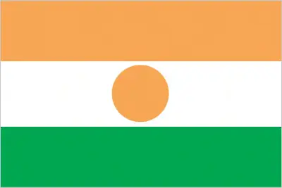 |
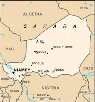
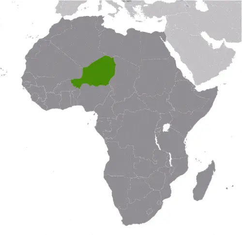
| Borderline map of Niger | Location map of Niger | Flag of Niger |
Google Maps and Detailed Facts of Niger (NE). This page lets you explore Niger and its border countries (Country Location: Western Africa, southeast of Algeria) through detailed Satellite imagery – fast and easy as never before Google Maps.
Find comprehensive information about this country’s diversity below: Google Maps, geography, economy, science, people, culture, environment, government, and history – All in One Wiki page.
There is also a Street View and free Driving Directions at your service. Your Google Satellite Map Sightseeing in Niger, in Africa, starts here at Driving Directions and Maps.com.
Niger Google Maps & Satellite Maps
The map below shows Niger with its cities, towns, highways, main roads, streets, and Street Views. To find a location, use the form below, type any city or place, view a simple map, and click the “show map” button.
The Google Maps above shows Niger with its location: Africa (geographic coordinates: 16 00 N, 8 00 E) and the international borders of Niger; total: 5,834 km. Border countries (total: 7): Algeria 951 km, Benin 277 km, Burkina Faso 622 km, Chad 1,196 km, Libya 342 km, Mali 838 km, Nigeria 1,608 km; furthermore, it’s inland counties boundaries.
Hint: Look at the Street view in Niger, or Africa. All you have to do is drag and pull the little yellow man (named: Pegman) on the Google Maps above the desired location. After that, whenever it is available (more than 50 countries globally), blue stripes will appear to show the photos and details from Google’s regularly updated data image base. In case if you have signed in to your Google account currently, you may have a look at the satellite map of this country/area as well.
The map of Niger, Africa, is for informational use only. No representation is made or warrantied given any map or its content by Driving Directions and Maps site. The user assumes all risks of using this Niger Google Maps and facts/wiki.
About Niger in detail
Where is Niger?
Niger, in case, if you are looking on the map under the Coordinates 13 31 N 2 07 E otherwise in Africa, in Western Africa, southeast of Algeria.
What is the capital city of Niger?
The capital city of Niger is Niamey.
What is the time in Niamey?
It is 6 hours ahead of Washington, D.C. during Standard Time; the timezone of Niamey is UTC+1.
What is the Internet code for Niger?
The Top Level Domain (TLD) for Niger is: .ne
What is the size of the Niger?
The territory of Niger is total: 1.267 million sq km; land: 1,266,700 sq km, water: 300 sq km.
If we want to describe the size of the territory of Niger is slightly less than twice the size of Texas.
If we would like to walk around and discover Niger, we can cover a total distance: 5,834 km.
What is the water coverage of Niger?
We have already mentioned what percentage of Niger is covered by water (see below), and this includes 0 km (landlocked country) coastline.
What is the climate like in Niger?
The climate of Niger is desert: mostly hot, dry, dusty: tropical in the extreme south.
Geographical data of Niger
The elevation of Niger; mean elevation: 474 m, elevation extremes; lowest point: Niger River 200 m, highest point: Idoukal-n-Taghes 2,022 m.
The specific geographical details of Niger include predominately desert plains and dunes, flat to rolling plains in the south, hills in the north.
Suppose we would like to describe the countries location from a different perspective. In that case, it is safe to say. It is easy to read from a map. Niger is a landlocked country; one of the hottest countries globally; northern four-fifths is desert, southern one-fifth is savanna, suitable for livestock and limited agriculture.
Resources and land use of Niger
The country’s main mined products are uranium, coal, iron ore, tin, phosphates, gold, molybdenum, gypsum, salt, petroleum. The population partly uses the earlier highlighted land territory and partly left in its natural state: agricultural land: 35.1%; arable land 12.3%; permanent crops 0.1%; permanent pasture 22.7%; forest: 1%; other: 63.9% (2011 estimate).
Population data of Niger
The number of inhabitants of Niger is 18,638,600 (July 2016 estimate).
If we examine the proportion of the population distribution, it is safe to say that most populace is located in the southernmost extreme of the country along the border with Nigeria and Benin.
If we look at the proportion of the urbanized and barely populated areas, these are the figures: urban population: 18.7% of the total population (2015).
Most of the population in Niger is concentrated in NIAMEY (capital) 1.09 million (2015).
Ethnicity in Niger
According to ethnicity details, the ethnic groups are Hausa 53.1%, Zarma/Songhai 21.2%, Tuareg 11%, Fulani (Peul) 6.5%, Kanuri 5.9%, Gurma 0.8%, Arab 0.4%, Tubu 0.4%, other/unavailable 0.9% (2006 estimate).
The spoken languages in Niger are the following: French (official language), Hausa, Djerma.
What are the most important religions in Niger?
According to this, during the general census, researchers examine the churches: Muslim 80%, other (includes indigenous beliefs and Christian) 20%.
Further population data of Niger
The proportion of gender and age tells a lot about the society as follows 0-14 years: 49.31% (male 4,635,901 / female 4,554,010) 15-24 years: 18.85% (male 1,734,887 / female 1,777,896) 25-54 years: 25.94% (male 2,414,668 / female 2,419,725) 55-64 years: 3.27% (male 316,655 / female 293,570) 65 years and over: 2.64% (male 250,314 / female 240,974) (2016 estimate). It also a significant factor in a society the population growth rate, which in the case of Niger is 3.22% (2016 estimate).
The population growth rate is based on two elements, the birth and the death rate. In Niger the birth rate is 44.8 births / 1,000 population (2016 estimate), the death rate 12.1 deaths / 1,000 population (2016 estimate).
In this day and age in developed societies, the first child borns later compared to the previous centuries and decades, so childbearing is extended. In Niger, the average age of mothers at the first childbirth is N/A.
Although the children’s birth is postponed in the best-case scenario, the parents can still see their kids grow as life expectancy also extended. In the case of Niger, these figures are. With the introduction of modern medicine, vaccinations, and the proper hygienic conditions, the infant mortality rate is in a steep decline. The infant mortality statistics in Niger are the following: N/A. Relevant data is the budget of healthcare, which is in this country’s case is 5.8% of GDP (2014).
Economic data of Niger
Suppose we would like to describe a country. We also have to mention its economy; Niger is a landlocked, sub-Saharan nation whose economy centers on subsistence crops, livestock, and some of the world’s largest uranium deposits. Agriculture contributes nearly 40% of GDP and provides a livelihood for most of the population. Since 2011 public debt has increased due to efforts to scale-up public investment, particularly related to infrastructure. The government relies on foreign donor resources for a large portion of its fiscal budget. Future growth may be sustained by exploiting oil, gold, coal, and other mineral resources. Although Niger has sizable oil reserves, the profitability of these commodities has been called into question due to the prolonged drop in oil prices.
GDP is a prominent figure, as all the relevant calculations and statistics are based on it. GDP in Niger is $7.566 billion (2015 estimate).
Another important indicator is the rate of GDP growth, which in Niger is 5.2% (2016 estimate), 3.5% (2015 estimate) 7.1% (2014 estimate).
These statistics affect the world economy; remember, in 2015, the Chinese real GDP growth rate was worse than expected; The world markets fall, and the Chinese stock exchange was temporarily suspended.
A further major factor of a country’s economy, the GDP per capita. In Niger this is $1,100 (2016 estimate) $1,100 (2015 estimate) $1,100 (2014 estimate).
In the economy, the Trinity is in common places, such as agriculture, industry, and services.
What are the agricultural products Niger produces?
The main agricultural products of Niger are cowpeas, cotton, peanuts, millet, sorghum, cassava (manioc, tapioca), rice, cattle, sheep, goats, camels, donkeys, horses, poultry.
The important segments are uranium mining, petroleum, cement, brick, soap, textiles, food processing, chemicals, and slaughterhouses. The crucial and regularly mentioned GDP is based on uranium mining, petroleum, cement, brick, soap, textiles, food processing, chemicals, slaughterhouses.
Drinking water source in Niger
It is essential to mention that – thanks to the development of the infrastructure -, the rate of potable water improved: urban: 100% of the population, rural: 48.6% of the population, total: 58.2% of the population. Unimproved: urban: 0% of the population, rural: 51.4% of the population, total: 41.8% of the population (2015 estimate).
The average number of childbirth in Niger
In Niger, the average delivery number is 6.62 children born / woman (2016 estimate).
Population, median age, migration, and citizenship in Niger
The population’s average age is 15.3 years; male: 15.2 years, female: 15.4 years (2016 estimate). The age of adulthood varies in every country of the world in Niger; it is 18 years of age, universal.
When we are experiencing an unprecedented scale of migration and globalization, it is an important factor in the number of new immigrants. In Niger is -0.5 migrant(s) / 1,000 population (2016 estimate). It is important to know how to apply for citizenship: citizenship by birth: no. Citizenship by descent only: at least one parent must be a citizen of Niger. Dual citizenship recognized: yes, the residency requirement for naturalization: unknown.
Is Niger a safe destination? Healthcare services and infectious diseases in Niger
Many of the travelers are looking into the healthcare services and infectious diseases of their destinations. In Niger, the hospital beds’ density is N/A.
According to the WHO rating regarding contagious diseases in Niger, the degree of risk: very high food or waterborne diseases: bacterial and protozoal diarrhea, hepatitis A, and typhoid fever vectorborne diseases: malaria and dengue fever water contact disease: schistosomiasis. Respiratory disease: meningococcal meningitis animal contact disease: rabies (2016).
However, HIV is not curable but maintainable. Let’s do not forget when the disease surfaced; it was a world threatening condition. Unfortunately, in some countries, it is still very high the number of infected patients and fatalities due to the disease.
In Niger, the number of HIV/AIDS deaths: N/A.
Regarding tourism obesity, not an important issue, but we have to mention health statistics, as it is the plague of the 20th and the 21st century. The rate of obese adults in Niger is 3.7% (2014).
What are the natural hazards in Niger? Is there any?
The most known natural risk in Niger is recurring droughts.
More interesting facts about Niger
A few words about the past, as every country and society, is connected to its history; Niger became independent from France in 1960 and experienced single-party and military rule until 1991 when Gen. Ali SAIBOU was forced by public pressure to allow multiparty elections, which resulted in a democratic government in 1993. Political infighting brought the government to a standstill and in 1996 led to a coup by Col. Ibrahim BARE. In 1999, BARE was killed in a counter-coup by military officers who restored democratic rule and held elections that brought Mamadou TANDJA to power in December of that year. TANDJA was re-elected in 2004 and in 2009 spearheaded a constitutional amendment allowing him to extend his term as president.
In February 2010, military officers led a coup that deposed TANDJA and suspended the constitution. ISSOUFOU Mahamadou was elected in April 2011 following the coup and re-elected to a second term in early 2016. Niger is one of the world’s poorest countries, with minimal government services and insufficient funds to develop its resource base. The largely agrarian and subsistence-based economy is frequently disrupted by extended droughts common to Africa’s Sahel region. A Tuareg rebellion emerged in 2007 and ended in 2009. Niger faces increased security concerns on its borders from various external threats, including insecurity in Libya, spillover from the conflict in Mali, and violent extremism in northeastern Nigeria.
In every nation’s memory, some cornerstones placed the country on the timeline of history. The date of declaration of independence of Niger: 3 August 1960 (from France).
The flag and other symbols of Niger
The colors, symbols, and animals on the flag usually have a historical background or an important milestone or memory of the nation.
This case is not an exception either; three equal horizontal bands of orange (top), white, and green with a small orange disk centered in the white band; the orange band denotes the drier northern regions of the Sahara; white stands for purity and innocence; green symbolizes hope and the fertile and productive southern and western areas, as well as the Niger River; the orange disc represents the sun and the sacrifices made by the people. Note: similar to India’s flag, which has a blue spoked wheel centered in the white band.
Apart from the flag, the symbol of national unity is the national anthem. The anthem’s primary purpose is to share the nation’s core values, endeavors, and patriotic feelings.
National symbols of Niger: zebu; national colors: orange, white, green.
Constitution of Niger
The existence of the nation is based on the constitution. Some constitutions knew worldwide, like the U.S. Constitution that was accepted on the 17th of September 1787, in Philadelphia, the United States of America’s Constitution.
It is not related to the declaration of independence that was stolen by Nicolas Cage in the movie National Treasure 🙂
What is the legal system of Niger?
Most of the time, the legal system of a country is the focus of lawyers. It is a common fact that there are two main approaches in the world, “the law in books” and “the law in action.”
In the Anglo-Saxon world, the practice is the “law in action,” while in the rest of the world, the law is based on Roman law, the “law in books.”
The legal system of Niger is a mixed legal system of civil law (based on French civil law), Islamic law, and customary law.
It was Aristotle who founded the Theory of 3 separations of powers. In his view, these are the council of public affairs, the magistrates, and the justice system. The age of enlightenment was the time when terminologies have defined the way we still use them. In most democratic countries, the three authorities separated from each other. In dictatorships, the rules usually interweaved in one hand.
About the legislative branch of Niger, we can highlight the following structures unicameral National Assembly or Assemblee Nationale (171 seats; 158 members directly elected from 8 multi-member constituencies in 7 regions and Niamey by party-list proportional representation, eight reserved for minorities elected in particular single-seat constituencies by simple majority vote, 5 seats reserved for Nigeriens living abroad – l seat per continent – elected in single-seat constituencies by simple majority vote; members serve 5-year terms); note – the number of National Assembly seats increased from 113 to 171 in February 2016.
About the unemployment rate, labor force, and poverty line in Niger
One of the major problems of the 21st-century economy is unemployment. Governments are struggling to maintain a low level of the unemployment rate. Still, as a result of automation, the cheap 3rd world labor, and the outsourcing of workflow, these attempts fail. In Niger, the labor force is 6.5 million (2016 estimate). Please bear in mind that the population in Niger is total: 82.8 deaths / 1,000 live births; male: 87.3 deaths / 1,000 live births, female: 78.2 deaths / 1,000 live births (2016 estimate) – as we already mentioned above.
The rate of unemployment in Niger is 5.1% (2015 estimate).
Widely known that the gap between the rich and poor is widening on an enormous scale.
According to the 2017 shocking Oxfam report, the most affluent eight people’s fortune is equal to the wealth of the poorest half of the world’s population.
In Niger, the households’ income and consumption compared to the entire population: lowest 10%: 3.7% highest 10%: 28.5% (2007).
Another widely used indicator is the so-called GINI index, which measures the inequalities of statistical dispersion, but is mainly used for measuring the sharing of income and fortune.
The GINI index was named after its founder Corrado Gini, an Italian economist. Gini index has grades between 0-1, but often it is used on a percentage basis. It is 0 if the examined criteria territorial distribution is equal. It is one of the criteria concentrated on the territory. In Niger, the GINI index is .34 (2007).
The states usually set up a poverty line, which is more or less, is a subjective measure. It varies by country; its base is often the minimum pension, the incomes of the most deficient 20 percent, the X percent of income per capita Etc.
In Niger, the poverty line people are the lowest 10%: 3.7% highest 10%: 28.5% (2007).
About the budget and central governments debt of Niger
The available budget mainly defines the state’s economy. The budget of Niger is; revenues: $1.715 billion, expenditures: $2.25 billion (2016 estimate). Taxes and other revenues are 22.7% of GDP (2016 estimate).
The budget deficit (Budget surplus (+) or deficit (-)) is N/A.
The fiscal year in Niger is the calendar year.
In the country’s economy, we have to consider the public debt. Public debt is the consolidated sum of the state’s local, federal, and central government debt.
Inflation rate and prime lending rate in Niger
A few further interesting and relevant economic data are the following; Inflation rate: 1.1% (2016 estimate), 1% (2015 estimate), and the rate of the Commercial bank prime lending rate: 3.5% (31 December 2016 estimate).
Export/import partners and data of Niger
Niger, with the export of products, industrial tools, and other services, generates revenue. The export value in Niger is: $1.1 billion (2016 estimate), $1.099 billion (2015 estimate). The total revenue of these activities: uranium ore, livestock, cowpeas, onions.
The most important export partners of Niger are France 53.1%, Nigeria 20.3%, China 13.8% (2015).
The most important imported products are foodstuffs, machinery, vehicles and parts, petroleum, cereals, and the countries from where the import is coming: France 12%, China 10.5%, Nigeria 9.5%, French Polynesia 9%, Togo 6.1%, Belgium 5.3%, Cote d’Ivoire 5.3%, US 4.3% (2015).
Renewable energies used in Niger
To suppress the pollution of the environment, renewable energies have to replace the fossil energy. The more the proportion of renewable energies in a country means more effort against pollution. Niger, the indicator of how much of the country’s produced energy is coming from the hydroelectric source, is 0% of total installed capacity (2012 estimate).
To indicate how much another renewable energy produced is 0% of total installed capacity (2012 estimate).
Telecommunication data of Niger, calling code
To maintain the economy, the development of a reliable and modern telecommunications infrastructure is crucial. We can say the following about Niger; inadequate; a small system of wire, radiotelephone communications, and microwave radio relay link concentrated in southwestern Nigerdomestic: combined fixed-line and mobile-cellular teledensity remain only about 50 per 100 persons despite a rapidly increasing cellular subscribership base; domestic satellite system with three earth stations and one planned. International: country code – 227; satellite earth stations – 2 Intelsat (1 the Atlantic Ocean and 1 Indian Ocean) (2015).
Transport infrastructure in Niger
In the 21st century, we often say that the world has become small and there are no distances anymore. With widespread air travel when (sometimes) there are no visa restrictions, it is easy to reach other countries, but if the distance is not too long, we can also use railway or water transportation.
The number of airports in Niger: 30 (2013), and the number of heliports: 1 (2013).
The total length of the roadways in Niger: 18,949 km, paved: 3,912 km, unpaved: 15,037 km (2010).
The total length of the waterways in Niger: 300 km (the Niger, the only major river, is navigable to Gaya between September and March) (2012).
Are you traveling to Niger?
If you plan to travel by plane to Niger, try our air ticket comparison site, where you can choose from hundreds of carriers and offers. Our application is scanning the market and shows you the best and the cheapest deals without any extra charge or commission.
Are you looking for a hotel, apartment another kind of accommodation in Niger, Africa? We are here to help you to find your accommodation from budget to luxury. Our search engine is scanning, regularly updating data from hundreds of accommodation websites and more than a million offers. You can quickly and easily find your hotel stay anywhere in the world, without any extra charge or commission.
Facts & data about Niger
Name of the country: conventional long way: the Republic of Niger, traditional short form: Niger, local long form: Republique du Niger, local short state: Niger, etymology: named for the Niger River that passes through the southwest of the country; from a native term “Ni Gir” meaning “River Gir.”
| Abbreviation: Niger | Geographic coordinates: 16 00 N, 8 00 E |
Country Location: Africa |
| Capital of Niger: Niamey | GPS of the Capital: 13 31 N 2 07 E |
Position: Western Africa, southeast of Algeria |
| Land area: total: 1.267 million sq km; land: 1,266,700 sq km, water: 300 sq km | Terrain: predominately desert plains and sand dunes; flat to rolling plains in south; hills in north |
Area comparative: slightly less than twice the size of Texas |
| Population: 18,638,600 (July 2016 estimate) | Population grow rate: 3.22% (2016 estimate) | Sex ratio: at birth: 1.03 male(s) / female, 0-14 years: 1.02 male(s) / female, 15-24 years: 0.98 male(s) / female, 25-54 years: 1 male(s) / female, 55-64 years: 1.08 male(s) / female, 65 years and over: 1.04 male(s) / female, total population: 1.01 male(s) / female (2016 estimate) |
| Exports: $1.1 billion (2016 estimate), $1.099 billion (2015 estimate) | Imports: $1.916 billion (2016 estimate), $1.888 billion (2015 estimate) | Import partners: France 12%, China 10.5%, Nigeria 9.5%, French Polynesia 9%, Togo 6.1%, Belgium 5.3%, Cote dIvoire 5.3%, US 4.3% (2015) |
| Urbanization: urban population: 18.7% of the total population (2015) | Major urban area(s): NIAMEY (capital) 1.09 million (2015) | Median age: total: 15.3 years; male: 15.2 years, female: 15.4 years (2016 estimate) |
| Internet users: total: 401,000. Percent of the population: 2.2% (July 2015 estimate) | Telephones (fixed-lines): total subscriptions: 110,000. Subscriptions per 100 inhabitants: 1 (July 2015 estimate) | Telephones (mobile, cellular): total: 8.959 million. Subscriptions per 100 inhabitants: 50 (July 2015 estimate) |
| Unemployment rate: 5.1% (2015 estimate) | Nationality: Nigerien(s) adjective: Nigerien | National holidays: Republic Day, 18 December (1958) |
| Life expectancy at birth: total population: 55.5 years. Male: 54.3 years, female: 56.8 years (2016 estimate) | Total fertility rate: 6.62 children born / woman (2016 estimate) | Birthrate: 44.8 births / 1,000 population (2016 estimate) |
| Literacy: age 15 and over can read and write. Total population: 19.1%; male: 27.3%, female: 11% (2015 estimate) | Legal system: mixed legal system of civil law (based on French civil law), Islamic law, and customary law | Suffrage: 18 years of age, universal |
| Industries: uranium mining, petroleum, cement, brick, soap, textiles, food processing, chemicals, slaughterhouses | Industrial production growth rate: 4.8% (2016 estimate) | GDP real growth rate: 5.2% (2016 estimate) 3.5% (2015 estimate) 7.1% (2014 estimate) |
Do you like this Niger Google Maps & country information page?
Please do us a favor: Share or like this page using the icons at the top of the page. We also do encourage you to visit our Facebook page for more travel and country related information.
Many thanks for visiting and sharing this map & country information site!