
 |
 |
 |
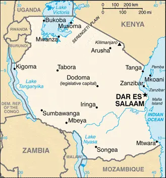
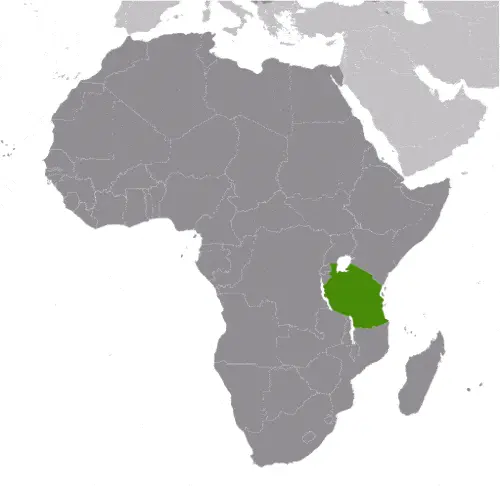
| Borderline map of Tanzania | Location map of Tanzania | Flag of Tanzania |
Google Maps and Detailed Facts of Tanzania (TZ). This page lets you explore Tanzania and its border countries (Country Location: Eastern Africa, bordering the Indian Ocean, between Kenya and Mozambique) through detailed Satellite imagery – fast and easy as never before Google Maps.
Find comprehensive information about this country’s diversity below: Google Maps, geography, economy, science, people, culture, environment, government, and history – All in One Wiki page.
There is also a Street View and free Driving Directions at your service. Your Google Satellite Map Sightseeing in Tanzania, in Africa, starts here at Driving Directions and Maps.com.
Tanzania Google Maps & Satellite Maps
The map below shows Tanzania with its cities, towns, highways, main roads, streets, and Street Views. To find a location, use the form below, type any city or place, view a simple map, and click the “show map” button.
The Google Maps above shows Tanzania with its location: Africa (geographic coordinates: 6 00 S, 35 00 E) and the international borders of Tanzania; total: 4,161 km. Border countries (total: 8): Burundi 589 km, the Democratic Republic of the Congo 479 km, Kenya 775 km, Malawi 512 km, Mozambique 840 km, Rwanda 222 km, Uganda 391 km, Zambia 353 km; furthermore, it’s inland counties boundaries.
Hint: Look at the Street view in Tanzania or Africa. All you have to do is drag and pull the little yellow man (named: Pegman) on the Google Maps above the desired location. After that, whenever it is available (more than 50 countries globally), blue stripes will appear to show the photos and details from Google’s regularly updated data image base. In case if you have signed in to your Google account currently, you may have a look at the satellite map of this country/area as well.
The map of Tanzania, Africa, is for informational use only. No representation is made or warrantied given any map or its content by Driving Directions and Maps site. The user assumes all risks of using this Tanzania Google Maps and facts/wiki.
About Tanzania in detail
Where is Tanzania?
In case Tanzania is looking on the map under the Coordinates 6 48 S 39 17 E otherwise in Africa, in Eastern Africa, bordering the Indian Ocean, between Kenya and Mozambique.
What is the capital city of Tanzania?
The capital city of Tanzania is Dodoma. The former capital of Tanzania is Dar es Salaam.
What is the time in Dodoma?
It is 8 hours ahead of Washington, D.C. during Standard Time; the timezone of Dodoma is UTC+3.
What is the Internet code for Tanzania?
The Top Level Domain (TLD) for Tanzania is: .tz
What is the size of Tanzania?
The territory of Tanzania is total: 947,300 sq km; land: 885,800 sq km, water: 61,500 sq km.
If we want to describe the size of Tanzania’s territory is more than six times the size of Georgia; slightly larger than twice the size of California.
If we would like to walk around and discover Tanzania, we can cover a total distance: 4,161 km.
What is the water coverage of Tanzania?
We have already mentioned what percentage of Tanzania is covered by water (see below), and this includes 1,424 km coastline.
What is the climate like in Tanzania?
The climate of Tanzania varies from tropical along the coast to temperate in the highlands.
Geographical data of Tanzania
Tanzania’s elevation; mean elevation: 1,018 m, elevation extremes; lowest point: Indian Ocean 0 m, highest point: Kilimanjaro 5,895 m.
Tanzania’s specific geographical details include plains along the coast; central plateau; highlands in north, south.
Suppose we would like to describe the countries location from a different perspective. In that case, it is safe to say, and easy to read from a map, Tanzania is Kilimanjaro is the highest point in Africa and one of only two mountains on the continent that has glaciers (the other is Mount Kenya); bordered by three of the largest lakes on the continent: Lake Victoria (the world’s second-largest freshwater lake) in the north, Lake Tanganyika (the world’s second deepest) in the west, and Lake Nyasa (Lake Malawi) in the southwest.
Resources and land use of Tanzania
The country’s main mined products are hydropower, tin, phosphates, iron ore, coal, diamonds, gemstones, gold, natural gas, nickel. The population partly uses the earlier highlighted land territory and partly left in its natural state: agricultural land: 43.7%; arable land 14.3%; permanent crops 2.3%; permanent pasture 27.1%; forest: 37.3%; other: 19% (2011 estimate).
Population data of Tanzania
The number of inhabitants of Tanzania is 52,482,726 (July 2016 estimate).
If we examine the proportion of the population distribution, it is safe to say that N/A.
If we look at the proportion of the urbanized and barely populated areas, these are the figures: urban population: 31.6% of the total population (2015).
Most of the Tanzania population is concentrated in DAR ES SALAAM (capital) 5.116 million; Mwanza 838,000 (2015).
Ethnicity in Tanzania
According to ethnicity details, the ethnic groups are mainland – African 99% (of which 95% are Bantu consisting of more than 130 tribes), other 1% (consisting of Asian, European, and Arab); Zanzibar – Arab, African, mixed Arab and African.
The spoken languages in Tanzania are the following: Kiswahili or Swahili (official language), Kiunguja (the name for Swahili in Zanzibar), English (official language, the primary language of commerce, administration, and higher education), Arabic (widely spoken in Zanzibar), many local languages. Note: Kiswahili (Swahili) is the mother tongue of the Bantu people living in Zanzibar and nearby coastal Tanzania; although Kiswahili is Bantu in structure and origin, its vocabulary draws on a variety of sources, including Arabic and English; it has become the lingua franca of central and eastern Africa; the first language of most people is one of the local languages.
What are the most important religions in Tanzania?
During the general census, researchers examine the churches, according to this: Christian 61.4%, Muslim 35.2%, folk religion 1.8%, other 0.2%, unaffiliated 1.4%note: Zanzibar is almost entirely Muslim (2010 estimate).
Further population data of Tanzania
The proportion of gender and age tells a lot about the society as follows 0-14 years: 44.06% (male 11,678,349 / female 11,444,708) 15-24 years: 19.71% (male 5,173,239 / female 5,169,214) 25-54 years: 29.74% (male 7,840,941 / female 7,767,797) 55-64 years: 3.5% (male 802,760 / female 1,034,151) 65 years and over: 2.99% (male 668,102 / female 903,465) (2016 estimate). It also a significant factor in a society the population growth rate, which in the case of Tanzania is 2.77% (2016 estimate).
The population growth rate is based on two elements, the birth, and the death rate. In Tanzania the birth rate is 36 births / 1,000 population (2016 estimate), the death rate 7.8 deaths / 1,000 population (2016 estimate).
In this day and age in developed societies, the first child borns later compared to the previous centuries and decades, so childbearing is extended. In Tanzania, the average age of mothers at the first childbirth is N/A.
Although the children’s birth is postponed in the best-case scenario, the parents can still see their kids grow as life expectancy also extended. In the case of Tanzania, these figures are. With the introduction of modern medicine, vaccinations, and the proper hygienic conditions, the infant mortality rate is in a steep decline. The infant mortality statistics in Tanzania are the following: N/A. Relevant data is the budget of healthcare, which is in this country’s case is 5.6% of GDP (2014).
Economic data of Tanzania
Suppose we would like to describe a country. We also have to mention its economy; Tanzania is one of the world’s poorest economies in terms of per capita income but has achieved high growth rates based on its vast natural resource wealth and tourism. GDP growth in 2009-16 was an impressive 6-7% per year. The economy depends on agriculture, which accounts for more than one-quarter of GDP, provides 85% of exports, and employs about 80% of the workforce; agriculture accounts for 7% of government expenditures. The government owns all land in Tanzania. Tanzania’s financial sector has expanded in recent years, and foreign-owned banks account for about 48% of the banking industry’s total assets. The World Bank, the IMF, and bilateral donors have provided funds to rehabilitate Tanzania’s aging infrastructure, including rail and port, that provide important trade links for inland countries. In 2013, Tanzania completed the world’s largest MillenniumIn in late 2014. A highly publicized scandal in the energy sector involving senior Tanzanian officials resulted in international donors freezing nearly $500 million in direct budget support to the government.
GDP is a prominent figure, as all the relevant calculations and statistics are based on it. GDP in Tanzania is $46.7 billion (2015 estimate).
Another important indicator is the rate of GDP growth, which in Tanzania is 7.2% (2016 estimate), 7% (2015 estimate) 7% (2014 estimate).
These statistics affect the world economy; remember, in 2015, the Chinese real GDP growth rate was worse than expected; The world markets fall, and the Chinese stock exchange was temporarily suspended.
A further major factor of a country’s economy, the GDP per capita. In Tanzania this is $3,100 (2016 estimate) $2,900 (2015 estimate) $2,800 (2014 estimate).
In the economy, the Trinity is in common places, such as agriculture, industry, and services.
What are the agricultural products Tanzania produces?
Tanzania’s main agricultural products are coffee, sisal, tea, cotton, pyrethrum (insecticide made from chrysanthemums), cashew nuts, tobacco, cloves, corn, wheat, cassava (manioc, tapioca), bananas, fruits, vegetables; cattle, sheep, goats.
Regarding the economy, the essential segments are agricultural processing (sugar, beer, cigarettes, sisal twine); mining (diamonds, gold, and iron), salt, soda ash; cement, oil refining, shoes, apparel, wood products, fertilizer. The crucial and regularly mentioned GDP is based on agricultural processing (sugar, beer, cigarettes, sisal twine); mining (diamonds, gold, and iron), salt, soda ash; cement, oil refining, shoes, apparel, wood products, fertilizer.
Drinking water source in Tanzania
It is essential to mention that – thanks to the development of the infrastructure -, the rate of potable water improved: urban: 77.2% of the population, rural: 45.5% of the people, total: 55.6% of the population. Unimproved: urban: 22.1% of the people, rural: 56% of the population, total: 46.8% of the population (2015 estimate).
The average number of childbirth in Tanzania
In Tanzania, the average delivery number is 4.83 children born / woman (2016 estimate).
Population, median age, migration, and citizenship in Tanzania
The population’s average age is 17.6 years; male: 17.3 years, female: 17.9 years (2016 estimate). The age of adulthood varies in every country of the world in Tanzania; it is 18 years of age, universal.
When we are experiencing an unprecedented scale of migration and globalization, it is an important factor in the number of new immigrants. In Tanzania is -0.5 migrant(s) / 1,000 population (2016 estimate). It is important to know how to apply for citizenship: citizenship by birth: no. Citizenship by descent only: at least one parent must be a citizen of Tanzania; if a child is born abroad, the father must be a Tanzania citizen. Dual citizenship recognized: no—the residency requirement for naturalization: 5 years.
Is Tanzania a safe destination? Healthcare services and infectious diseases in Tanzania
Many of the travelers are looking into the healthcare services and infectious diseases of their destinations. In Tanzania, the hospital beds’ density is 0.7 beds / 1,000 population (2010).
According to the WHO rating regarding contagious diseases in Tanzania, the degree of risk: very high food or waterborne diseases: bacterial diarrhea, hepatitis A, and typhoid fever vectorborne diseases: malaria, dengue fever, and Rift Valley fever water contact diseases: schistosomiasis and leptospirosis. Animal contact disease: rabies, (2016).
However, HIV is not curable but maintainable. Let’s do not forget when the disease surfaced; it was a world threatening condition. Unfortunately, in some countries, it is still very high the number of infected patients and fatalities due to the disease.
In Tanzania, the number of HIV/AIDS deaths: N/A.
Regarding tourism obesity, not an important issue, but we have to mention health statistics, as it is the plague of the 20th and the 21st century. The rate of obese adults in Tanzania is 5.9% (2014).
What are the natural hazards in Tanzania? Is there any?
The most known natural risk in Tanzania are flooding on the central plateau during the rainy season; drought. Volcanism: limited volcanic activity; Ol Doinyo Lengai (elevation 2,962 m) has emitted lava in recent years; other historically active volcanoes include Kieyo and Meru.
More interesting facts about Tanzania
A few words about the past, as every country and society, are connected to its history; Shortly after achieving independence from Britain in the early 1960s, Tanganyika and Zanzibar merged to form the United Republic Tanzania in 1964. One-party rule ended in 1995 with the first democratic elections held in the country since the 1970s. Zanzibar’s semi-autonomous status and widespread opposition led to two contentious elections since 1995, which the ruling party won despite international observers’ claims of voting irregularities. The formation of a national unity government between Zanzibar’s two leading parties succeeded in minimizing electoral tension in 2010.
In every nation’s memory, some cornerstones placed the country on the timeline of history. The date of declaration of independence of Tanzania: 26 April 1964; Tanganyika became independent on 9 December 1961 (from UK-administered UN trusteeship); Zanzibar became independent on 10 December 1963 (from the UK); Tanganyika united with Zanzibar on 26 April 1964 to form the United Republic of Tanganyika and Zanzibar; renamed the United Republic of Tanzania on 29 October 1964.
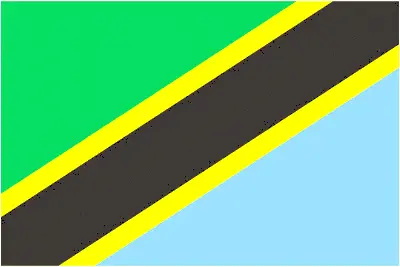
The flag and other symbols of Tanzania
The colors, symbols, and animals on the flag usually have a historical background or an important milestone or memory of the nation.
This case is not an exception either; divided diagonally by a yellow-edged black band from the lower hoist-side corner; the upper triangle (hoist side) is green, and the lower triangle is blue; the banner combines colors found on the flags of Tanganyika and Zanzibar; green represents the natural vegetation of the country, gold its fatty mineral deposits, black the native Swahili people, and blue the country’s many lakes and rivers, as well as the Indian Ocean.
Apart from the flag, the symbol of national unity is the national anthem. The anthem’s primary purpose is to share the nation’s core values, endeavors, and patriotic feelings.
Tanzania’s national symbols: Uhuru (Freedom) torch, giraffe; national colors: green, yellow, blue, black.
Constitution of Tanzania
The existence of the nation is based on the constitution. Some constitutions knew worldwide, like the U.S. Constitution that was accepted on the 17th of September 1787, in Philadelphia, the United States of America’s Constitution.
It is not related to the declaration of independence that was stolen by Nicolas Cage in the movie National Treasure 🙂
What is the legal system of Tanzania?
Most of the time, the legal system of a country is the focus of lawyers. It is a common fact that there are two main approaches in the world, “the law in books” and “the law in action.”
In the Anglo-Saxon world, the practice is the “law in action,” while in the rest of the world, the law is based on Roman law, the “law in books.”
Tanzania’s legal system is English common law; judicial review of legislative acts limited to matters of interpretation.
It was Aristotle who founded the Theory of 3 separations of powers. In his view, these are the council of public affairs, the magistrates, and the justice system. The age of enlightenment was the time when terminologies have defined the way we still use them. In most democratic countries, the three authorities separated from each other. In dictatorships, the rules usually interweaved in one hand.
About the legislative branch of Tanzania, we can highlight the following structures unicameral National Assembly or Parliament (Bunge) (357 seats; 239 members directly elected in single-seat constituencies by simple majority vote, 102 women directly elected by proportional representation vote, 5 indirectly elected by simple majority vote by the Zanzibar House of Representatives, 10 appointed by the president, and 1 seat reserved for the attorney general; members serve a 5-year term); note – in addition to enacting laws that apply to the entire United Republic of Tanzania, the National Assembly enacts laws that apply only to the mainland; Zanzibar has its own House of Representatives or Baraza La Wawakilishi (81 seats; 50 members directly elected in single-seat constituencies by simple majority vote, 15 women directly elected by proportional representation vote, 10 appointed by the Zanzibar president, 5 seats reserved for government-appointed regional commissioners, and 1 seat for the attorney general; elected members serve a 5-year term).
About the unemployment rate, labor force, and poverty line in Tanzania
One of the major problems of the 21st-century economy is unemployment. Governments are struggling to maintain a low level of the unemployment rate. Still, as a result of automation, the cheap 3rd world labor, and the outsourcing of workflow, these attempts fail. In Tanzania, the labor force is 26.96 million (2016 estimate). Please bear in mind that the population in Tanzania is total: 41.2 deaths / 1,000 live births; male: 43.2 deaths / 1,000 live births, female: 39.1 deaths / 1,000 live births (2016 estimate) – as we already mentioned above.
The rate of unemployment in Tanzania is N/A %.
Widely known that the gap between the rich and poor is widening on an enormous scale.
According to the 2017 shocking Oxfam report, the most affluent eight people’s fortune is equal to the wealth of the poorest half of the world’s population.
In Tanzania, the households’ income and consumption compared to the entire population: lowest 10%: 2.8% highest 10%: 29.6% (2007).
Another widely used indicator is the so-called GINI index, which measures the inequalities of statistical dispersion, but is mainly used for measuring the sharing of income and fortune.
The GINI index was named after its founder Corrado Gini, an Italian economist. Gini index has grades between 0-1, but often it is used on a percentage basis. It is 0 if the examined criteria territorial distribution is equal. It is one of the criteria concentrated on the territory. In Tanzania, the GINI index is .37,6 (2007).
The states usually set up a poverty line, which is more or less, is a subjective measure. It varies by country; its base is often the minimum pension, the incomes of the most deficient 20 percent, the X percent of income per capita Etc.
In Tanzania, the poverty line people are the lowest 10%: 2.8% highest 10%: 29.6% (2007).
About the budget and central governments debt of Tanzania
The available budget mainly defines the state’s economy. Tanzania’s budget is; revenues: $6.257 billion, expenditures: $8.084 billion (2016 estimate). Taxes and other revenues are 13.4% of GDP (2016 estimate).
The budget deficit (Budget surplus (+) or deficit (-)) is N/A.
The fiscal year in Tanzania is 1 July – 30 June.
In the country’s economy, we have to consider the public debt. Public debt is the consolidated sum of the state’s local, federal, and central government debt.
Inflation rate and prime lending rate in Tanzania
A few further interesting and relevant economic data are the following; Inflation rate: 5.2% (2016 estimate), 5.6% (2015 estimate), and the rate of the Commercial bank prime lending rate: 14.2% (31 December 2016 estimate).
Export/import partners and data of Tanzania
Tanzania, with the export of products, industrial tools, and other services, generates revenue. Tanzania’s export value is $5.985 billion (2016 estimate), $5.709 billion (2015 estimate). The total revenue of these activities: gold, coffee, cashew nuts, manufacturers, cotton.
Tanzania’s most important export partners are India 21.4%, China 8.1%, Japan 5.1%, Kenya 4.6%, Belgium 4.3% (2015).
The most important imported products are consumer goods, machinery, and transportation equipment, industrial raw materials, crude oil, and the countries from where the import is coming: China 34.6%, India 13.5%, South Africa 4.7%, UAE 4.4%, Kenya 4.1% (2015).
Renewable energies used in Tanzania
To suppress the pollution of the environment, renewable energies have to replace the fossil energy. The more the proportion of renewable energies in a country means more effort against pollution. Tanzania, the indicator of how much of the country’s produced energy is coming from the hydroelectric source, is 66.5% of total installed capacity (2012 estimate).
To indicate how much another renewable energy produced is 0% of total installed capacity (2012 estimate).
Telecommunication data of Tanzania, calling code
To maintain the economy, the development of a reliable and modern telecommunications infrastructure is crucial. We can say the following about Tanzania; telecommunications services are marginal; system operating below capacity and being modernized for better service. Domestic: fixed-line telephone network inadequate with less than one connection per 100 persons; mobile-cellular service, aided by multiple providers, is increasing rapidly and exceeds 75 telephones per 100 persons; trunk service provided by open-wire, microwave radio. International: country code – 255; landing point for the EASSy fiber-optic submarine cable system linking East Africa with Europe and North America; satellite earth stations – 2 Intelsat (one Indian Ocean, one the Atlantic Ocean) (2015).
Transport infrastructure in Tanzania
In the 21st century, we often say that the world has become small and there are no distances anymore. With widespread air travel when (sometimes) there are no visa restrictions, it is easy to reach other countries, but if the distance is not too long, we can also use railway or water transportation.
The number of airports in Tanzania: 166 (2013), and the number of heliports: N/A.
The total length of the roadways in Tanzania: 86,472 km, paved: 7,092 km, unpaved: 79,380 km (2010).
The total length of the waterways in Tanzania: (Lake Tanganyika, Lake Victoria, and Lake Nyasa (Lake Malawi) are the principal avenues of commerce with neighboring countries; the rivers are not navigable) (2011).
Are you traveling to Tanzania?
If you plan to travel by plane to Tanzania, try our air ticket comparison site, where you can choose from hundreds of carriers and offers. Our application is scanning the market and shows you the best and the cheapest deals without any extra charge or commission.
Are you looking for a hotel, apartment another kind of accommodation in Tanzania, Africa? We are here to help you to find your accommodation from budget to luxury. Our search engine is scanning, regularly updating data from hundreds of accommodation websites and more than a million offers. You can quickly and easily find your hotel stay anywhere in the world, without any extra charge or commission.
Facts & data about Tanzania
Name of the country: conventional long way: the United Republic of Tanzania, traditional short form: Tanzania, local long form: Jamhuri ya Muungano wa Tanzania, local short state: Tanzania, former: United Republic of Tanganyika and Zanzibar. Note: the country’s name is a combination of Tanganyika and Zanzibar’s first letters, the two states that merged to form Tanzania in 1964.
| Abbreviation: Tanzania | Geographic coordinates: 6 00 S, 35 00 E |
Country Location: Africa |
| Capital of Tanzania: Dodoma | GPS of the Capital: 6 48 S 39 17 E |
Position: Eastern Africa, bordering the Indian Ocean, between Kenya and Mozambique |
| Land area: total: 947,300 sq km; land: 885,800 sq km, water: 61,500 sq km | Terrain: plains along coast; central plateau; highlands in north, south |
Area comparative: more than six times the size of Georgia; slightly larger than twice the size of California |
| Population: 52,482,726 (July 2016 estimate) | Population grow rate: 2.77% (2016 estimate) | Sex ratio: at birth: 1.03 male(s) / female, 0-14 years: 1.02 male(s) / female, 15-24 years: 1 male(s) / female, 25-54 years: 1.01 male(s) / female, 55-64 years: 0.78 male(s) / female, 65 years and over: 0.75 male(s) / female, total population: 0.99 male(s) / female (2016 estimate) |
| Exports: $5.985 billion (2016 estimate), $5.709 billion (2015 estimate) | Imports: $9.976 billion (2016 estimate), $9.843 billion (2015 estimate) | Import partners: China 34.6%, India 13.5%, South Africa 4.7%, UAE 4.4%, Kenya 4.1% (2015) |
| Urbanization: urban population: 31.6% of the total population (2015) | Major urban area(s): DAR ES SALAAM (capital) 5.116 million; Mwanza 838,000 (2015) | Median age: total: 17.6 years; male: 17.3 years, female: 17.9 years (2016 estimate) |
| Internet users: total: 2.734 million. Percent of the population: 5.4% (July 2015 estimate) | Telephones (fixed-lines): total subscriptions: 142,819. Subscriptions per 100 inhabitants: less than 1 (July 2015 estimate) | Telephones (mobile, cellular): total: 39.666 million. Subscriptions per 100 inhabitants: 78 (July 2015 estimate) |
| Unemployment rate: N/A % | Nationality: Tanzanian(s) adjective: Tanzanian | National holidays: Union Day (Tanganyika and Zanzibar), 26 April (1964) |
| Life expectancy at birth: total population: 62.2 years. Male: 60.8 years, female: 63.6 years (2016 estimate) | Total fertility rate: 4.83 children born / woman (2016 estimate) | Birthrate: 36 births / 1,000 population (2016 estimate) |
| Literacy: age 15 and over can read and write Kiswahili (Swahili), English, or Arabic. Total population: 70.6%; male: 75.9%, female: 65.4% (2015 estimate) | Legal system: English common law; judicial review of legislative acts limited to matters of interpretation | Suffrage: 18 years of age, universal |
| Industries: agricultural processing (sugar, beer, cigarettes, sisal twine); mining (diamonds, gold, and iron), salt, soda ash; cement, oil refining, shoes, apparel, wood products, fertilizer | Industrial production growth rate: 6% (2016 estimate) | GDP real growth rate: 7.2% (2016 estimate) 7% (2015 estimate) 7% (2014 estimate) |
Do you like this Tanzania Google Maps & information page?
Please do us a favor: Share or like this page using the icons at the top of the page. We also do encourage you to visit our Facebook page for more travel and country related information.
Thank you for visiting and sharing this map & country information page.