Driving Directions American Samoa
AMERICAN SAMOA is an „unincorporated” territory of the USA. It lies close to Western Samoa in the Pacific Ocean and comprises five main volcanic islands and two coral atolls.

Google Maps, Country Facts and Route Planner
Explore the countries in Oceania with all their Wiki, find information on weather, population, facts, history, landmarks of major cities data, and enjoy free Google maps Satellite imagery & Street views. Each Country Profile in Oceania provides information on Geography data, area maps, Google maps, flag, history, area, population, the capital city, largest cities, economy, spoken languages, ethnicity/race, religion, literacy rate, government, and many more!
In this map category of Oceania, you will find these countries and their capital cities:
Australia, Fiji, Kiribati, Marshall Islands, Micronesia, Nauru, New Zealand, Palau, Papua New Guinea, Samoa, Solomon Islands, Tonga, Tuvalu, Vanuatu.
AMERICAN SAMOA is an „unincorporated” territory of the USA. It lies close to Western Samoa in the Pacific Ocean and comprises five main volcanic islands and two coral atolls.
Google Maps and detailed facts about American Samoa (AS). This page lets you explore American Samoa and its border countries (Country Location: Oceania, a group of islands in the South Pacific Ocean, about halfway between Hawaii and New Zealand) through detailed Satellite imagery – fast and easy as never before Google Maps.
Find comprehensive information about this country’s diversity below: Google Maps, geography, economy, science, people, culture, environment, government, and history – All in One Wiki page.
There is also a Street View and free Driving Directions at your service. Your Google Satellite Map Sightseeing in American Samoa, in Oceania, starts here at Driving Directions and Maps.com.
Apia is one of the most populated cities in Samoa, and at the same time, this city is the capital of this country. Located in Oceania, you may find the city easily with the following GPS coordinates: 13.50S latitude / 171.50W longitude. For routing in Apia, please check the free driving directions Apia service below.
Are you ready for a virtual adventure to one of Earth’s most remote and fascinating places? Strap in because today we’re diving into the Ashmore and Cartier Islands – a hidden gem in the vast Indian Ocean. These islands are a paradise to explore with their pristine beaches, diverse wildlife, and enchanting coral reefs. And what better way to embark on this journey than through Google Maps? Join us as we navigate this breathtaking archipelago from the comfort of our screens. So grab your imagination goggles and prepare for an unforgettable virtual expedition!
AUSTRALIA, the world’s smallest continental landmass, is a vast and sparsely populated country in the southern hemisphere, whose head of state is the British Sovereign. It consists of seven self-governing states: New South Wales, Northern Territory, Queensland, South Australia, Tasmania, Victoria, and Western Australia. The capital, Canberra, is situated in the Australian Capital Territory (ACT).
Canberra is one of the most populated cities in Australia, and at the same time, this city is the capital of this country. Located in Oceania, you may quickly find the town with the following GPS coordinates: 35.15S latitude / 149.08E longitude. For routing in Canberra, please check the free driving directions Canberra service below.
 |
 |
 |
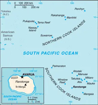
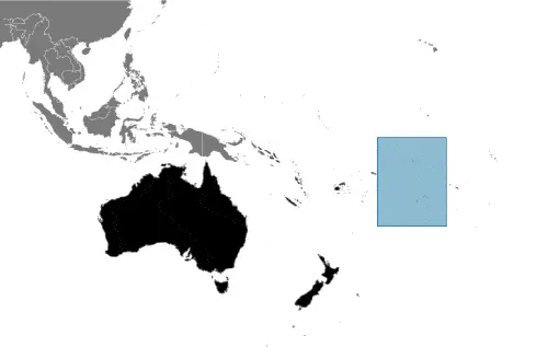
| Borderline map of Cook Islands | Location map of Cook Islands | Flag of Cook Islands |
Google Maps and Detailed Facts of Cook Islands (CK). This page lets you explore the Cook Islands and its border countries (Country Location: Oceania, group of islands in the South Pacific Ocean, about halfway between Hawaii and New Zealand) through detailed Satellite imagery – fast and easy as never before Google Maps.
Find comprehensive information about this country’s diversity below: Google Maps, geography, economy, science, people, culture, environment, government, and history – All in One Wiki page.
There is also a Street View and free Driving Directions at your service. In Oceania, your Google Satellite Map Sightseeing in the Cook Islands starts here at Driving Directions and Maps.com.
Dili is one of the most populated cities in East Timor, and at the same time, this city is the capital of this country. Located in Oceania, you may find the city easily with the following GPS coordinates: 08.29S latitude / 125.34E longitude. For routing in Dili, please check the free driving directions Dili service below.
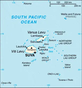
FIJI is a part of Melanesia and comprises more than 800 islands, only about 100 inhabited. It is one of the largest nations in the western Pacific and situated around the 180° International Date Line and about 17° south of the Equator. The two main islands, Viti Levu and Vanua Levu, are extinct volcanoes, and most of the islands in the group fringed with coral reefs.
 |
 |
 |
| Borderline map of Fiji | Location map of Fiji | Flag of Fiji |
Google Maps and Detailed Facts of Fiji (FJ). This page lets you explore Fiji and its border countries (Country Location: Oceania, island group in the South Pacific Ocean, about two-thirds of the way from Hawaii to New Zealand) through detailed Satellite imagery – fast and easy as never before Google Maps.
Find comprehensive information about this country’s diversity below: Google Maps, geography, economy, science, people, culture, environment, government, and history – All in One Wiki page.
There is also a Street View and free Driving Directions at your service. Your Google Satellite Map Sightseeing in Fiji, in Oceania, starts here at Driving Directions and Maps.com.