
 |
 |
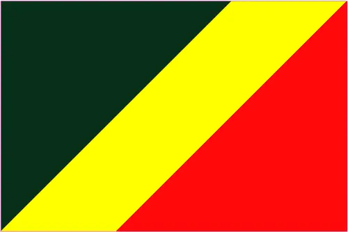 |
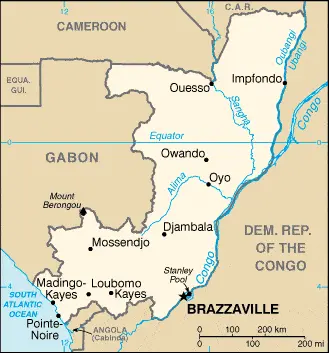
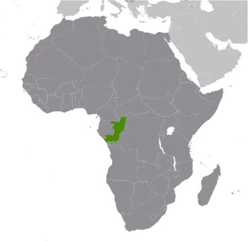
| Borderline map of Republic of the Congo | Location map of Republic of the Congo | Flag of Republic of the Congo |
Republic of the Congo Google Maps
Google Maps and Detailed Facts of the Republic of the Congo (CF). This page lets you explore the Republic of the Congo and its border countries (Country Location: Central Africa, bordering the South Atlantic Ocean, between Angola and Gabon) through detailed Satellite imagery – fast and easy as never before Google Maps.
Find comprehensive information about this country’s diversity below: Google Maps, geography, economy, science, people, culture, environment, government, and history – All in One Wiki page.
There is also a Street View and free Driving Directions at your service. Your Google Satellite Map Sightseeing in the Republic of the Congo, in Africa, starts here at Driving Directions and Maps.com.
The Republic of the Congo Google Maps & Satellite Maps
The map below shows the Republic of the Congo with its cities, towns, highways, main roads, streets, and Street Views. To find a location, use the form below, type any city or place, view a simple map, and click the “show map” button.
The Google Maps above shows the Republic of the Congo with its location: Africa (geographic coordinates: 1 00 S, 15 00 E) and Republic of the Congo; total: 5,008 km. Border countries (total: 5): Angola 231 km, Cameroon 494 km, Central African Republic 487 km, the Democratic Republic of the Congo 1,229 km, Gabon 2,567 km; furthermore, it’s inland counties boundaries.
Hint: Look at the Street view in the Republic of the Congo or Africa. All you have to do is drag and pull the little yellow man (named: Pegman) on the Google Maps above the desired location. After that, whenever it is available (more than 50 countries globally), blue stripes will appear to show the photos and details from Google’s regularly updated data image base. In case if you have signed in to your Google account currently, you may have a look at the satellite map of this country/area as well.
The map of the Republic of the Congo, Africa, is for informational use only. No representation is made or warrantied given any map or its content by Driving Directions and Maps site. The user assumes all risks of using this Republic of the Congo Google Maps and facts/wiki.
About the Republic of the Congo in detail
Where is the Republic of the Congo?
The Republic of the Congo, in case, if you are looking on the map under the Coordinates 4 15 S 15 17 E otherwise in Africa, in Central Africa, bordering the South Atlantic Ocean, between Angola and Gabon.
What is the capital city of the Republic of the Congo?
The capital city of the Republic of the Congo is Brazzaville.
What is the time in Brazzaville?
It is 6 hours ahead of Washington, D.C. during Standard Time; Brazzaville’s timezone is UTC+1.
What is the Internet code for the Republic of the Congo?
The Top Level Domain (TLD) for the Republic of the Congo is: .cg
What is the size of the Republic of the Congo?
The Republic of the Congo territory is total: 342,000 sq km; land: 341,500 sq km, water: 500 sq km.
If we want to describe the Republic of the Congo territory’s size, it is somewhat smaller than Montana.
If we would like to walk around and discover the Republic of the Congo, we can cover a total distance: 5,008 km.
What is the water coverage of the Republic of the Congo?
We have already mentioned what percentage of the Republic of the Congo is covered by water (see below), including a 169 km coastline.
What is the climate like in the Republic of the Congo?
The Republic of the Congo’s climate is tropical: rainy season (March to June): the dry season (June to October): persistent high temperatures and humidity: particularly enervating climate astride the Equator.
Geographical data of Republic of the Congo
The elevation of the Republic of the Congo; mean elevation: 430 m, elevation extremes; lowest point: Atlantic Ocean 0 m, highest point: Mount Berongou 903 m.
The Republic of the Congo’s specific geographical details includes coastal plain, southern basin, central plateau, and northern basin.
Suppose we would like to describe the countries location from a different perspective. In that case, it is safe to say, and easy to read from a map, the Republic of the Congo is about 70% of the population lives in Brazzaville, Pointe-Noire, or along the railroad between them.
Resources and land use of the Republic of the Congo
The country’s main mined products are petroleum, timber, potash, lead, zinc, uranium, copper, phosphates, gold, magnesium, natural gas, hydropower. The population partly uses the earlier highlighted land territory and partly left in its natural state: agricultural land: 31.1%; arable land 1.6%; permanent crops 0.2%; permanent pasture 29.3%; forest: 65.6%; other: 3.3% (2011 estimate).
Population data of Republic of the Congo
The number of inhabitants of the Republic of the Congo is 4,852,412 (July 2016 estimate).
If we look at the proportion of the urbanized and barely populated areas, these are the figures: urban population: 65.4% of the total population (2015).
Most of the Republic of the Congo population is concentrated in BRAZZAVILLE (capital) 1.888 million; Pointe-Noire 969,000 (2015).
Ethnicity in the Republic of the Congo
According to ethnicity details, the ethnic groups are Kongo 48%, Sangha 20%, M’Bochi 12%, Teke 17%, Europeans, and 3%.
Spoken languages in Republic of the Congo
The spoken languages in the Republic of the Congo are the following: French (official language), Lingala and Monokutuba (lingua franca trade languages), many local languages and dialects (of which Kikongo is the most widespread).
What are the most important religions in the Republic of the Congo?
According to this, during the general census, researchers examine the churches: Roman Catholic 33.1%, Awakening Churches/Christian Revival 22.3%, Protestant 19.9%, Salutiste 2.2%, Muslim 1.6%, Kimbanguiste 1.5%, other 8.1%, none 11.3% (2010 estimate).
Further population data of Republic of the Congo
The proportion of gender and age tells a lot about the society as follows 0-14 years: 41.53% (male 1,016,677 / female 998,331) 15-24 years: 17.26% (male 419,248 / female 418,397) 25-54 years: 34% (male 831,091 / female 818,853) 55-64 years: 4.18% (male 101,118 / female 101,879) 65 years and over: 3.03% (male 64,519 / female 82,299) (2016 estimate). It also a significant factor in a society the population growth rate, which in the case of Republic of the Congo is 2.06% (2016 estimate).
The population growth rate is based on two elements, the birth, and the death rate. In Republic of the Congo the birth rate is 35.1 births / 1,000 population (2016 estimate), the death rate 9.7 deaths / 1,000 population (2016 estimate).
In this day and age in developed societies, the first child borns later compared to the previous centuries and decades, so childbearing is extended. In the Republic of the Congo, the average age of mothers at the first childbirth is N/A.
Although the children’s birth is postponed in the best-case scenario, the parents can still see their kids grow as life expectancy also extended. In the case of the Republic of the Congo, these figures are. With the introduction of modern medicine, vaccinations, and the proper hygienic conditions, the infant mortality rate is in a steep decline. The infant mortality statistics in the Republic of the Congo are the following: N/A. Relevant data is the budget of healthcare, which is in the case of this country is 5.2% of GDP (2014).
Economic data of Republic of the Congo
Suppose we would like to describe a country. We also have to mention its economy; The economy is a mixture of subsistence farming and hunting, an industrial sector based mainly on oil and support services, and government spending. Oil has supplanted forestry as the mainstay of the economy, providing a significant share of government revenueEconomic reform efforts have been undertaken with the support of international organizations, notably the World Bank and the IMF, including the recently concluded Article IV consultations. The current administration faces difficult economic challenges. Officially the country became a net external creditor as of 2011, with external debt representing only about 16% of GDP and debt servicing less than 3% of government revenue.
GDP is a prominent figure, as all the relevant calculations and statistics are based on it. GDP in the Republic of the Congo is $8.834 billion (2015 estimate).
Another important indicator is the rate of GDP growth, which in the Republic of the Congo is 1.7% (2016 estimate), 2.3% (2015 estimate) 6.8% (2014 estimate).
These statistics affect the world economy; remember, in 2015, the Chinese real GDP growth rate was worse than expected; The world markets fall, and the Chinese stock exchange is temporally suspended.
A further major factor of a country’s economy, the GDP per capita. In Republic of the Congo this is $6,800 (2016 estimate) $6,800 (2015 estimate) $6,800 (2014 estimate).
In the economy, the Trinity is in common places, such as agriculture, industry, and services.
What are the agricultural products the Republic of the Congo produces?
The Republic of the Congo’s main agricultural products is cassava (manioc, tapioca), sugar, rice, corn, peanuts, vegetables, coffee, cocoa, and forest products.
The essential segments are petroleum extraction, cement, lumber, brewing, sugar, palm oil, soap, flour, and cigarettes. The crucial and regularly mentioned GDP is based on petroleum extraction, cement, lumber, brewing, sugar, palm oil, soap, flour, cigarettes.
Drinking water source in the Republic of the Congo
It is essential to mention that – thanks to the development of the infrastructure -, the rate of potable water improved: urban: 95.8% of the population, rural: 40% of the people, total: 76.5% of the community. Unimproved: urban: 4.2% of the people, rural: 60% of the population, total: 23.5% of the population (2015 estimate).
The average number of childbirth in the Republic of the Congo
In the Republic of the Congo, the average delivery number is 4.63 children born / woman (2016 estimate).
Population, median age, migration, and citizenship in Republic of the Congo
The population’s average age is 19.7 years; male: 19.6 years, female: 19.9 years (2016 estimate). The age of adulthood varies in every country of the world. In the Republic of the Congo, it is 18 years of age, universal.
When we are experiencing an unprecedented scale of migration and globalization, it is an important factor in the number of new immigrants. In Republic of the Congo is -4.8 migrant(s) / 1,000 population (2016 estimate). It is important to know how to apply for citizenship: citizenship by birth: no. Citizenship by descent only: at least one parent must be a citizen of the Congo Republic. Dual citizenship recognized: no—residency requirement for naturalization: 10 years.
Is the Republic of the Congo a safe destination? Healthcare services and infectious diseases in the Republic of the Congo
Many of the travelers are looking into the healthcare services and infectious diseases of their destinations. In the Republic of the Congo, the hospital beds’ density is N/A.
According to the WHO rating regarding contagious diseases in the Republic of the Congo, the degree of risk: very high food or waterborne diseases: bacterial and protozoal diarrhea, hepatitis A, and typhoid fever vectorborne disease: malaria and dengue fever animal contact disease: rabies water contact disease: schistosomiasis (2016).
However, HIV is not curable but maintainable. Let’s do not forget when the disease surfaced; it was a world threatening condition. Unfortunately, in some countries, it is still very high the number of infected patients and fatalities due to the disease.
In the Republic of the Congo, the number of HIV/AIDS deaths: N/A.
Regarding tourism obesity, not an important issue, but we have to mention health statistics, as it is the plague of the 20th and the 21st century. The rate of obese adults in the Republic of the Congo is 9.7% (2014).
What are the natural hazards in the Republic of the Congo? Is there any?
The most known natural risk in the Republic of the Congo is seasonal flooding.
More interesting facts about the Republic of the Congo
A few words about the past, as every country and society, is connected to its history; Upon independence in 1960, the former French region of Middle Congo became the Republic of the Congo. A quarter-century of experimentation with Marxism was abandoned in 1990, and a democratically elected government took office in 1992. A brief civil war in 1997 restored former Marxist President Denis SASSOU-Nguesso. It ushered in a period of ethnic and political underestimate Southern-based rebel groups agreed to a final peace accord in March 2003. The Republic of Congo is one of Africa’s largest petroleum producers, but with declining production, new offshore oil will need to sustain its oil earnings over the long term.
In every nation’s memory, some cornerstones placed the country on the timeline of history. The date of declaration of Republic of the Congo independence: 15 August 1960 (from France).
The flag and other symbols of the Republic of the Congo
The colors, symbols, and animals on the flag usually have a historical background or an important milestone or memory of the nation.
This case is not an exception either; divided diagonally from the lower hoist-side by a yellow band; the upper triangle (hoist side) is green, and the lower triangle is red; green symbolizes agriculture and forests, yellow the friendship and nobility of the people, red is unexplained but has been associated with the struggle for independence. Note: uses the popular Pan-African colors of Ethiopia.
Apart from the flag, the symbol of national unity is the national anthem. The anthem’s primary purpose is to share the nation’s core values, endeavors, and patriotic feelings.
National symbols of the Republic of the Congo: lion, elephant; national colors: green, yellow, red.
Constitution of Republic of the Congo
The existence of the nation is based on the constitution. Some constitutions knew worldwide, like the U.S. Constitution that was accepted on the 17th of September 1787, in Philadelphia, the United States of America’s Constitution.
It is not related to the declaration of independence that was stolen by Nicolas Cage in the movie National Treasure 🙂
What is the legal system of the Republic of the Congo?
Most of the time, the legal system of a country is the focus of lawyers. It is a common fact that there are two main approaches in the world, “the law in books” and “the law in action.”
In the Anglo-Saxon world, the practice is the “law in action,” while in the rest of the world, the law is based on Roman law, the “law in books.”
The Republic of the Congo’s legal system is a mixed legal system of French civil law and customary law.
It was Aristotle who founded the Theory of 3 separations of powers. In his view, these are the council of public affairs, the magistrates, and the justice system. The age of enlightenment was the time when terminologies have defined the way we still use them. In most democratic countries, the three authorities separated from each other. In dictatorships, the rules usually interweaved in one hand.
About the legislative branch of the Republic of the Congo, we can highlight the following structures bicameral Parliament or Parlement consists of the Senate (72 seats; members indirectly elected by regional councils by simple majority vote to serve 6-year terms with one-half of membership renewed every three years) and the National Assembly (139 seats; members directly elected in single-seat constituencies by absolute majority popular vote in two rounds if needed; members serve 5-year terms).
About the unemployment rate, labor force, and poverty line in the Republic of the Congo
One of the major problems of the 21st-century economy is unemployment. Governments are struggling to maintain a low level of the unemployment rate. Still, as a result of automation, the cheap 3rd world labor, and the outsourcing of workflow, these attempts fail. In the Republic of the Congo, the labor force is 1.807 million (2013 estimate). Please bear in mind that the population in Republic of the Congo is total: 56.4 deaths / 1,000 live births; male: 61.4 deaths / 1,000 live births, female: 51.3 deaths / 1,000 live births (2016 estimate) – as we already mentioned above.
The rate of unemployment in the Republic of the Congo is 53% (2012 estimate).
Widely known that the gap between the rich and poor is widening on an enormous scale.
According to the 2017 shocking Oxfam report, the most affluent eight people’s fortune is equal to the wealth of the poorest half of the world’s population.
In the Republic of the Congo, the households’ income and consumption compared to the entire population: lowest 10%: 2.1% highest 10%: 37.1% (2005).
Another widely used indicator is the so-called GINI index, which measures the inequalities of statistical dispersion, but is mainly used for measuring the sharing of income and fortune.
The GINI index was named after its founder Corrado Gini, an Italian economist. Gini index has grades between 0-1, but often it is used on a percentage basis. It is 0 if the examined criteria territorial distribution is equal. It is one of the criteria concentrated on the territory. In the Republic of the Congo, the GINI index is N/A.
The states usually set up a poverty line, which is more or less, is a subjective measure. It varies by country; its base is often the minimum pension, the incomes of the most deficient 20 percent, the X percent of income per capita Etc.
In the Republic of the Congo, the poverty line people are the lowest 10%: 2.1% highest 10%: 37.1% (2005).
About the budget and central governments debt of the Republic of the Congo
The available budget mainly defines the state’s economy. Republic of the Congo’s budget is; revenues: $3.562 billion, expenditures: $4.233 billion (2016 estimate). Taxes and other revenues are 40.3% of GDP (2016 estimate).
The budget deficit (Budget surplus (+) or deficit (-)) is N/A.
The fiscal year in the Republic of the Congo is the calendar year.
In the country’s economy, we have to consider the public debt. Public debt is the consolidated sum of the state’s local, federal, and central government debt.
Inflation rate and prime lending rate in the Republic of the Congo
A few further interesting and relevant economic data are the following; Inflation rate: 2.3% (2016 estimate), 2.6% (2015 estimate), and the rate of the Commercial bank prime lending rate: 14% (31 December 2016 estimate).
Export/import partners and data of Republic of the Congo
With the export of products, industrial tools, and other services, the Republic of the Congo generates revenue. The Republic of the Congo’s export value is $4.777 billion (2016 estimate), $5.231 billion (2015 estimate). The total revenue of these activities: petroleum, lumber, plywood, sugar, cocoa, coffee, diamonds.
The most important export partners of the Republic of the Congo are China 42.1%, Italy 16.9%, the United States 4.9%, India 4.7%, Portugal 4.2% (2015).
The most important imported products are capital equipment, construction materials, foodstuffs, and the countries from where the import is coming: China 20.3%, France 14.2%, South Korea 9.8%, the United States 4.9%, United Kingdom 4.4%, Italy 4.1%, India 4.1% (2015).
Renewable energies used in Republic of the Congo
To suppress the pollution of the environment, renewable energies have to replace the fossil energy. The more the proportion of renewable energies in a country means more effort against pollution. The Republic of the Congo, the indicator of how much of the country’s produced energy is coming from the hydroelectric source, is 87.8% of total installed capacity (2012 estimate).
To indicate how much another renewable energy produced is 0% of total installed capacity (2012 estimate).
Telecommunication data of Republic of the Congo, calling code
To maintain the economy, the development of a reliable and modern telecommunications infrastructure is crucial. We can say the following about the Republic of the Congo; primary network consists of microwave radio relay and coaxial cable with services barely adequate for government use; key exchanges are in Brazzaville, Pointe-Noire, and Loubomo; intercity lines frequently out of order. Domestic: fixed-line infrastructure inadequate, providing less than one connection per 100 persons; in the absence of adequate fixed-line infrastructure, mobile-cellular subscribership has surged to 110 per 100 persons. International: country code – 242; satellite earth station – 1 Intelsat (Atlantic Ocean) (2015).
Transport infrastructure in the Republic of the Congo
In the 21st century, we often say that the world has become small and there are no distances anymore. With widespread air travel when (sometimes) there are no visa restrictions, it is easy to reach other countries, but if the distance is not too long, we can also use railway or water transportation.
The number of airports in the Republic of the Congo: 27 (2013) and the number of heliports: N/A.
The total length of the roadways in the Republic of the Congo: total: 17,000 km, paved: 1,212 km, unpaved: 15,788 km (2006).
The total length of the waterways in Republic of the Congo: 1,120 km (commercially navigable on Congo and Oubanqui Rivers above Brazzaville; there are many ferries across the river to Kinshasa; the Congo south of Brazzaville-Kinshasa to the coast is not passable because of rapids, necessitating a rail connection to Pointe Noire; other rivers are used for local traffic only) (2011).
Are you traveling to the Republic of the Congo?
If you plan to travel by plane to the Republic of the Congo, try our air ticket comparison site, where you can choose from hundreds of carriers and offers. Our application is scanning the market and shows you the best and the cheapest deals without any extra charge or commission.
Are you looking for a hotel, apartment another kind of accommodation in the Republic of the Congo, Africa? We are here to help you to find your accommodation from budget to luxury. Our search engine is scanning, regularly updating data from hundreds of accommodation websites and more than a million offers. You can quickly and easily find your hotel stay anywhere in the world, without any extra charge or commission.
Facts & data about Republic of the Congo
Name of the country: conventional long way: Republic of the Congo, traditional short form: Congo (Brazzaville), local long form: Republique du Congo, local short state: Congo, former: French Congo, Middle Congo, People’s Republic of the Congo, Congo/Brazzaville, etymology: named for the Congo River, which makes up much of the country’s eastern border; the river name derives from Kongo, a Bantu kingdom that occupied its mouth at the time of Portuguese discovery in the late 15th century and whose name stems from its people the Bakongo, meaning “hunters.”
| Abbreviation: Republic of the Congo | Geographic coordinates: 1 00 S, 15 00 E |
Country Location: Africa |
| Capital of Republic of the Congo: Brazzaville | GPS of the Capital: 4 15 S 15 17 E |
Position: Central Africa, bordering the South Atlantic Ocean, between Angola and Gabon |
| Land area: total: 342,000 sq km; land: 341,500 sq km, water: 500 sq km | Terrain: coastal plain, southern basin, central plateau, northern basin |
Area comparative: somewhat smaller than Montana |
| Population: 4,852,412 (July 2016 estimate) | Population grow rate: 2.06% (2016 estimate) | Sex ratio: at birth: 1.03 male(s) / female, 0-14 years: 1.02 male(s) / female, 15-24 years: 1 male(s) / female, 25-54 years: 1.01 male(s) / female, 55-64 years: 0.99 male(s) / female, 65 years and over: 0.78 male(s) / female, total population: 1.01 male(s) / female (2016 estimate) |
| Exports: $4.777 billion (2016 estimate), $5.231 billion (2015 estimate) | Imports: $3.447 billion (2016 estimate), $3.934 billion (2015 estimate) | Import partners: China 20.3%, France 14.2%, South Korea 9.8%, US 4.9%, UK 4.4%, Italy 4.1%, India 4.1% (2015) |
| Urbanization: urban population: 65.4% of the total population (2015) | Major urban area(s): BRAZZAVILLE (capital) 1.888 million; Pointe-Noire 969,000 (2015) | Median age: total: 19.7 years; male: 19.6 years, female: 19.9 years (2016 estimate) |
| Internet users: total: 362,000. Percent of the population: 7.6% (July 2015 estimate) | Telephones (fixed-lines): total subscriptions: 17,000. Subscriptions per 100 inhabitants: less than 1 (July 2015 estimate) | Telephones (mobile, cellular): total: 5.216 million. Subscriptions per 100 inhabitants: 110 (July 2015 estimate) |
| Unemployment rate: 53% (2012 estimate) | Nationality: Congolese (singular and plural) adjective: Congolese or Congo | National holidays: Independence Day, 15 August (1960) |
| Life expectancy at birth: total population: 59.3 years. Male: 58.1 years, female: 60.6 years (2016 estimate) | Total fertility rate: 4.63 children born / woman (2016 estimate) | Birthrate: 35.1 births / 1,000 population (2016 estimate) |
| Literacy: age 15 and over can read and write. Total population: 79.3%; male: 86.4%, female: 72.9% (2015 estimate) | Legal system: mixed legal system of French civil law and customary law | Suffrage: 18 years of age, universal |
| Industries: petroleum extraction, cement, lumber, brewing, sugar, palm oil, soap, flour, cigarettes | Industrial production growth rate: 3.5% (2016 estimate) | GDP real growth rate: 1.7% (2016 estimate) 2.3% (2015 estimate) 6.8% (2014 estimate) |
Do you like this Republic of the Congo Google Maps & country information page?
Please do us a favor: Share or like this page using the icons at the top of the page. We also do encourage you to visit our Facebook page for more travel and country related information.
Many thanks for visiting and sharing this map & country information site!