
Google Maps and Detailed Facts of Burundi (BY). This page lets you explore Burundi and its border countries (Country Location: Central Africa, east of the Democratic Republic of the Congo, west of Tanzania) through detailed Satellite imagery – fast and easy as never before Google Maps.
Find comprehensive information about this country’s diversity below: Google Maps, geography, economy, science, people, culture, environment, government, and history – All in One Wiki page.
There is also a Street View and free Driving Directions at your service. Your Google Satellite Map Sightseeing in Burundi, Africa, starts here at Driving Directions and Maps.com.
About Burundi in detail
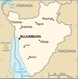
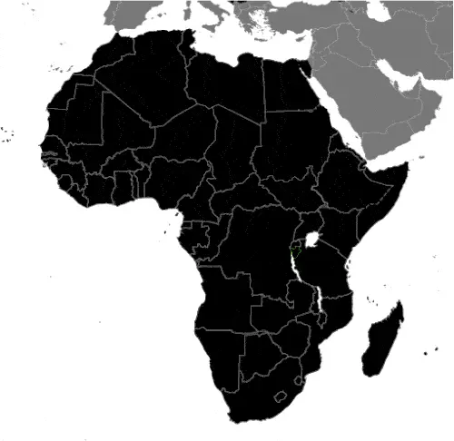
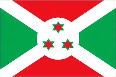
Table of contents
- Background
- Overview
- Google Maps
- Climate
- Geography
- Resources and Land Use
- Population Data
- Economic Data
- Drinking Water Source
- Population, Median Age, Migration, and Citizenship
- Average Number of Childbirths
- Is this country a Safe Destination?
- Healthcare and Infectious Diseases
- Natural Hazards
- The Flag and Other Symbols
- Constitution
- Legal System
- About the Unemployment Rate, Labor Force, and Poverty Line
- About the Budget and Central Government Debt
- Inflation Rate and Prime Lending Rate
- Export/Import Partners and Data
- Renewable Energies Used
- Telecommunication Data, Calling Code
- Transport Infrastructure
- More Interesting Facts
Background
Burundi, established in the 1600s, has a history marked by the coexistence and later conflict between its major ethnic groups, the Hutu and the Tutsi. Following German and Belgian colonial rule, Burundi preserved its monarchy until independence in 1962. The assassination of a Tutsi king’s son in 1961 and subsequent political turmoil led to ethnic polarization. A failed Hutu-led coup in 1965 and a Tutsi rebellion in 1972 resulted in severe ethnic violence and massacres. After a civil war from 1993 to 2005, Burundi held its second democratic elections in 2005, electing Pierre Nkurunziza as president. Evariste Ndayishimiye was elected in 2020 from Nkurunziza’s ruling party.
Overview
The Burundi Kingdom was established in the 1600s and has had similar borders to modern-day Burundi since the 1800s. The kingdom consisted of two major ethnic groups, the Hutu majority and the Tutsi minority, who shared a language and culture. Under Tutsi monarchs, the two groups coexisted peacefully in pre-colonial Burundi, although social status was determined by regional, class, and clan distinctions.
The monarchy was preserved during German and Belgian colonial rule in the late 19th and early 20th centuries. However, Belgian officials sought to simplify administration by reducing the number of chiefdoms and limiting the power of Hutu chiefs. In 1961, the oldest son of the Burundian Tutsi king, Louis RWAGASORE, was assassinated by a political faction, leading to increased political competition and later instability.
Burundi gained independence from Belgium in 1962 as the Kingdom of Burundi. Ethnic tensions were heightened by the revolution in neighboring Rwanda, as the Tutsi population in Burundi feared violence and loss of political power. A failed Hutu-led coup in 1965 resulted in the purge of Hutu officials and the overthrow of the monarchy by Tutsi officers in 1966, establishing a Tutsi-dominated republic.
In 1972, a Hutu rebellion led to the killing of several thousand Tutsi civilians, followed by a brutal crackdown on Hutu civilians by the Tutsi-led military, resulting in the deaths of an estimated 100,000-200,000 people. International pressure led to a new constitution in 1992 and democratic elections in June 1993. However, the first democratically elected Hutu president, Melchior NDADAYE, was assassinated in October 1993 by Tutsi military officers, sparking a civil war.
Further ethnic conflict was triggered when President Cyprien NTARYAMIRA died in April 1994 in the plane crash that also sparked the Rwandan genocide. The Arusha Agreement, brokered by the international community in 2000 and subsequent cease-fire agreements, ended the civil war from 1993 to 2005.
In 2005, Burundi held its second democratic elections, resulting in the election of Pierre NKURUNZIZA as president. He was reelected in 2010 and 2015 despite controversy surrounding a court decision that allowed him to bypass term limits. In 2020, Evariste NDAYISHIMIYE from NKURUNZIZA’s ruling party was elected as the current president of Burundi.
Official Name: Republic of Burundi
Capital: Gitega
Population: 13,162,952 (2023 estimate)
Total Area: 27,830 sq km
Languages: Kirundi (official), French (official), English (official), Swahili
Religions: Roman Catholic 58.6%, Protestant 35.3%, Muslim 3.4%
Ethnic Groups: Hutu, Tutsi, Twa, Phuthi, South Asian
Government: Presidential republic
Currency: Burundian franc (BIF)
Literacy Rate: 74.7%
Burundi Google Maps
Burundi, nestled in the heart of Africa, is a land of rolling hills and lush landscapes. Google Maps helps explore this scenic beauty, highlighting its main cities like Bujumbura and the diverse geography ranging from the northern shores of Lake Tanganyika to the fertile volcanic soils in rural areas.
The map below shows Burundi’s cities, towns, highways, main roads, streets, and Street Views. To find a location, use the form below, type any city or place, view a simple map, and click the “show map” button.
The Google Maps above shows Burundi’s location: Africa (geographic coordinates: 3 30 S, 30 00 E) and the international borders of Burundi; total: 1,140 km. Border countries (total: 3): the Democratic Republic of the Congo, 236 km; Rwanda, 315 km; and Tanzania, 589 km; furthermore, its inland boundaries.
The map of Burundi, Africa, is for informational use only. No representation is made or warrantied given any map or content by the Driving Directions and Maps site. The user assumes all risks of using this Burundi Google Maps and facts/wiki.
Climate
Burundi’s equatorial climate, influenced significantly by its varied altitude, presents a range of climatic conditions across different regions of the country. Here’s an extended look at the climate of Burundi with factual details:
Altitude Variation and Climate:
- Burundi’s climate varies considerably due to its topography. The country’s altitude ranges from 772 meters (2,533 feet) at the lowest point in the Rift Valley to 2,670 meters (8,760 feet) at Mount Heha, the highest point.
- This altitude variation results in a climate generally more temperate than expected for an equatorial country. The highlands are cooler, while the lowlands are warmer.
Average Temperatures:
- Average annual temperatures vary based on altitude. In the higher altitudes, the average temperature ranges around 17°C (63°F), whereas in the lower-lying areas, it can be around 23°C (73°F).
- The warmest months are typically September to May, while June to August are cooler.
Rainfall Patterns:
- The average annual rainfall is about 150 cm (59 inches), which can be higher in mountainous areas.
- Burundi experiences two main rainy seasons: the long rains from February to May and the short rains from September to November.
- The dry seasons occur from June to August and December to January, with the June to August period being cooler and less humid.
Regional Climatic Differences:
- The western regions adjacent to Lake Tanganyika generally experience higher temperatures and lower altitudes.
- The central plateau and the eastern highlands have more moderate temperatures due to their higher elevations.
Impact on Agriculture:
- The climate significantly impacts agriculture, the mainstay of Burundi’s economy. The rainfall pattern is crucial for cultivating crops like coffee, tea, sugar, cotton, and various food crops.
- The variability of the rainy seasons can sometimes lead to challenges such as droughts or floods, affecting agricultural productivity.
Climate Change Concerns:
Like many other regions, Burundi faces challenges related to climate change. These include changes in rainfall patterns and intensity, which can lead to agricultural disruptions and food insecurity.
Microclimates:
The complex topography of Burundi creates various microclimates in different parts of the country, influencing local weather conditions, flora, and fauna.
Environmental Impact:
- The climate and terrain support a diverse range of ecosystems, from savanna in the lowlands to montane forests in the highlands.
- However, environmental issues such as deforestation and soil erosion are challenges exacerbated by climatic factors.
Burundi’s climate is characterized by its equatorial location and significant altitude variation, resulting in a generally moderate climate with two wet and two dry seasons annually. While supporting diverse ecosystems and agriculture, this climatic variation also presents challenges, particularly in changing global climate patterns.
Geography
Burundi’s geographical landscape is characterized by its hilly and mountainous terrain, significantly influencing its environment and biodiversity. Here’s an extended look at Burundi’s geography, including information about its surrounding countries:
Hilly and Mountainous Terrain:
- Most of Burundi’s terrain is hilly and mountainous, particularly in the western regions. These areas are part of the Albertine Rift, the western branch of the East African Rift system.
- The mountains gradually descend into plateaus as one moves eastward, with the central plateau being one of the most prominent features.
Highest Point: Burundi’s highest point is an unnamed Mukike Range peak, reaching 2,685 meters (8,809 feet). This peak is part of the highlands running north-south through the country’s western part.
Lowest Point: The lowest point is Lake Tanganyika, at 772 meters (2,533 feet) above sea level. Lake Tanganyika is one of the African Great Lakes known for its rich biodiversity, particularly its unique fish species.
Lake Tanganyika: As the second deepest and second largest by volume freshwater lake in the world, Lake Tanganyika plays a vital role in the region’s ecology and economy. It is a critical source of water for fishing and irrigation.
- Despite its small size, Burundi boasts rich biodiversity. The country’s varied landscapes, from mountains to lakes, support a wide range of ecosystems and are home to numerous species of plants, birds, reptiles, and mammals.
- Important species include hippos, crocodiles in Lake Tanganyika, and various endemic bird species.
Climate Influence: The geographical features, including elevation changes, significantly influence the local climate, leading to varied weather conditions across different country regions.
Natural Resources: Burundi has several natural resources, including arable land, nickel, uranium, rare earth oxides, peat, cobalt, copper, platinum, and gold. However, the rugged terrain and lack of infrastructure can make these resources challenging to exploit.
Surrounding Countries:
- Burundi is landlocked and bordered by three countries:
- Rwanda to the north,
- Tanzania to the east and south,
- Democratic Republic of the Congo (DRC) to the west.
Environmental Challenges: The country faces several environmental challenges, such as deforestation, soil erosion, and habitat loss, which threaten its biodiversity and natural resources.
Agricultural Land: Much of the country’s population relies on agriculture, practiced even on the steep slopes of the hills, leading to terraced landscapes in many rural areas.
In summary, Burundi’s geography, dominated by hilly and mountainous terrain with a significant drop to a plateau in the east, shapes its rich biodiversity and natural environment. The country’s highest and lowest points add to its diverse ecological zones, which, along with its location relative to surrounding countries, play a crucial role in its ecological, economic, and social fabric.
Resources and Land Use
Burundi’s natural resources include nickel, uranium, rare earth oxides, and arable land. Agricultural land comprises 73.3% of land use, with significant cultivation of cassava, bananas, sweet potatoes, and beans.
Population Data
With a high population density, most Burundians live on farms near fertile volcanic soil, particularly in the north and along Lake Tanganyika’s northern shore. The country faces challenges due to high population growth and limited land availability.
Economic Data
Burundi’s economy is agricultural and low-income, with a GDP of $8.849 billion (2021 est.). Declining foreign assistance, fiscal insolvencies, and the effects of the COVID-19 pandemic hamper the economy.
Drinking Water Source
Access to improved drinking water sources stands at 81.6% of the population, with a higher rate in urban areas (98.7%) compared to rural areas (78.9%).
Population, Median Age, Migration, and Citizenship
The median age in Burundi is 18.2 years. The country has a net migration rate of 6.8 migrants/1,000 population, indicating significant movement of people.
Average Number of Childbirths
The total fertility rate in Burundi is high, with 4.96 children born per woman (2023 est.).
Is this country a Safe Destination?
Due to ongoing political instability and ethnic tensions, safety in Burundi can be a concern. Travelers are advised to stay informed and exercise caution.
Healthcare and Infectious Diseases
Healthcare facilities are limited, and common diseases include malaria, hepatitis A, and typhoid fever. The risk of infectious diseases is very high.
Natural Hazards
Burundi is prone to flooding, landslides, and drought, particularly affecting its agricultural sector.
The Flag and Other Symbols
Burundi’s flag features red and green panels divided by a white diagonal cross, with a white disk bearing three red six-pointed stars. The lion is a national symbol representing strength and courage.
Constitution
The current constitution, ratified in 2005 and amended in 2018, established a presidential republic. The amendments extended the presidential term from 5 to 7 years and reintroduced the position of prime minister.
Legal System
Burundi’s legal system is a mix of Belgian civil law and customary law, reflecting its colonial history and local traditions.
About the Unemployment Rate, Labor Force, and Poverty Line
The unemployment rate is 1.79% (2021 est.), but poverty remains widespread, with 64.6% of the population living below the poverty line (2014 est.).
About the Budget and Central Government Debt
Burundi’s public debt was 51.7% of GDP in 2017, with fiscal management being a critical challenge for the government.
Inflation Rate and Prime Lending Rate
The inflation rate stood at 8.4% in 2021, reflecting the country’s economic challenges.
Export/Import Partners and Data
Key exports include gold, coffee, and tea, primarily to the United Arab Emirates. Major imports from countries like China and India include refined petroleum and packaged medicines.
Renewable Energies Used
Burundi’s energy sector relies significantly on hydroelectric power, with efforts to expand renewable energy sources.
Telecommunication Data, Calling Code
The telecommunications sector is growing, focusing on mobile cellular networks. The country code is +257.
Transport Infrastructure
Transportation infrastructure includes roads, a few airports with paved runways, and waterways, mainly on Lake Tanganyika.
More Interesting Facts
Burundi is known for its cultural diversity, traditional drumming performances, and beautiful landscapes. However, it faces significant challenges related to poverty, political instability, and ethnic tensions.
Did You Know?
- Heart of Africa: Burundi is often called the “Heart of Africa” due to its heart-like shape and central location on the African continent.
- Ancient Drumming Tradition: The country is renowned for its traditional drumming, particularly the Royal Drummers of Burundi, who have been performing for centuries. This drumming, known as “Umutwe,” is an important part of Burundi’s cultural heritage and is recognized by UNESCO.
- One of the Smallest Countries in Africa: Despite its rich culture and biodiversity, Burundi is one of the smallest countries in Africa, roughly the size of Maryland in the United States.
- Biodiversity Hotspot: Lake Tanganyika, which forms part of Burundi’s western border, is the world’s second-deepest and second-largest freshwater lake by volume. It’s known for its unique fish species, many of which are found nowhere else on Earth.
- Agricultural Society: Over 90% of Burundi’s population is involved in agriculture, primarily subsistence farming. The country is a major producer of coffee and tea, which are critical to its economy.
- High Altitude: Despite its size, Burundi’s terrain varies, ranging from a plateau to mountainous regions. The highest point is an unnamed peak on the Mukike Range at 2,685 meters (8,809 feet).
- Diverse Languages: While Kirundi and French are the official languages, Swahili is also widely spoken, especially in urban areas and along the Tanzanian border.
- Rich Craftsmanship: Burundi has a rich tradition of craftsmanship, including basketry, mask-making, and beadwork, reflecting the country’s artistic heritage and cultural identity.
- Young Population: Burundi has a very young population, with a significant majority under the age of 25. This demographic structure presents both challenges and opportunities for the nation’s development.
- Rusizi National Park: The Rusizi National Park is a natural reserve in Burundi, known for its diverse wildlife, including hippopotamuses, antelopes, and various bird species. The park is a crucial sanctuary for protecting the country’s wildlife and natural landscapes.
These interesting facts about Burundi highlight its unique position as a cultural and ecological treasure in the heart of Africa, with a rich history, diverse ecosystems, and vibrant traditions.
Many thanks for visiting and sharing this map & country information site!