
 |
 |
 |
| Borderline map of Malawi | Location map of Malawi | Flag of Malawi |
Google Maps and Detailed Facts of Malawi (MW). This page lets you explore Malawi and its border countries (Country Location: Southern Africa, east of Zambia, west, and north of Mozambique) through detailed Satellite imagery – fast and easy as never before Google Maps.
Find comprehensive information about this country’s diversity below: Google Maps, geography, economy, science, people, culture, environment, government, and history – All in One Wiki page.
There is also a Street View and free Driving Directions at your service. Your Google Satellite Map Sightseeing in Malawi, in Africa, starts here at Driving Directions and Maps.com.
Malawi Google Maps & Satellite Maps
The map below shows Malawi with its cities, towns, highways, main roads, streets, and Street Views. To find a location, use the form below, type any city or place, view a simple map, and click the “show map” button.
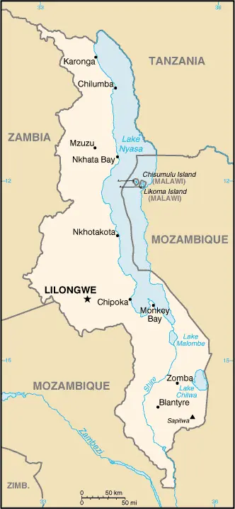
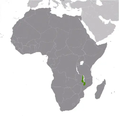
The Google Maps above shows Malawi with its location: Africa (geographic coordinates: 13 30 S, 34 00 E) and the international borders of Malawi; total: 2,857 km. Border countries (total: 3): Mozambique 1,498 km, Tanzania 512 km, Zambia 847 km; furthermore, it’s inland counties boundaries.
Hint: Look at the Street view in Malawi, or Africa. All you have to do is drag and pull the little yellow man (named: Pegman) on the Google Maps above the desired location. After that, whenever it is available (more than 50 countries globally), blue stripes will appear to show the photos and details from Google’s regularly updated data image base. In case if you have signed in to your Google account currently, you may have a look at the satellite map of this country/area as well.
The map of Malawi, Africa, is for informational use only. No representation is made or warrantied given any map or its content by Driving Directions and Maps site. The user assumes all risks of using this Malawi Google Maps and facts/wiki.
About Malawi in detail
Where is Malawi?
Malawi, in case, if you are looking on the map under the Coordinates 13 58 S 33 47 E otherwise in Africa, in Southern Africa, east of Zambia, west, and north of Mozambique.
What is the capital city of Malawi?
The capital city of Malawi is Lilongwe.
What is the time in Lilongwe?
It is 7 hours ahead of Washington, D.C. during Standard Time; the timezone of Lilongwe is UTC+2.
What is the Internet code for Malawi?
The Top Level Domain (TLD) for Malawi is: .mw
What is the size of Malawi?
The territory of Malawi is total: 118,484 sq km; land: 94,080 sq km, water: 24,404 sq km.
If we want to describe the size of the territory of Malawi is somewhat smaller than Pennsylvania.
If we would like to walk around and discover Malawi, we can cover a total distance: 2,857 km.
What is the water coverage of Malawi?
We have already mentioned what percentage of Malawi is covered by water (see below), and this includes 0 km (landlocked country) coastline.
What is the climate like in Malawi?
Malawi’sMalawi’s climate is sub-tropical: rainy season (November to May): the dry season (May to November).
Geographical data of Malawi
Malawi’s elevation; mean elevation: 779 m, elevation extremes; lowest point: junction of the Shire River and international boundary with Mozambique 37 m, highest point: Sapitwa 3,002 m.
Malawi’s specific geographical details include a narrow, elongated plateau with rolling plains, rounded hills, some mountains.
Suppose we would like to describe the countries location from a different perspective. In that case, it is safe to say, and easy to read from a map, Malawi is a landlocked country; Lake Nyasa, some 580 km long, is the country’s most prominent physical feature; it contains more fish species than any other lake on earth.
Resources and land use of Malawi
The country’s main mined products are limestone, arable land, hydropower, unexploited uranium deposits, coal, and bauxite. The population partly uses the earlier highlighted land territory and partly left in its natural state: agricultural land: 59.2%; arable land 38.2%; permanent crops 1.4%; permanent pasture 19.6%; forest: 34%; other: 6.8% (2011 estimate).
Population data of Malawi
The number of inhabitants of Malawi is 18,570,321 (July 2016 estimate).
If we examine the proportion of the population distribution, it is safe to say that N/A.
If we look at the proportion of the urbanized and barely populated areas, these are the figures: urban population: 16.3% of the total population (2015).
Most of Malawi’s population is concentrated in LILONGWE (capital) 905,000; Blantyre-Limbe 808,000 (2015).
Ethnicity in Malawi
According to ethnicity details, the ethnic groups are Chewa 32.6%, Lomwe 17.6%, Yao 13.5%, Ngoni 11.5%, Tumbuka 8.8%, Nyanja 5.8%, Sena 3.6%, Tonga 2.1%, Ngonde 1%, other 3.5%.
Spoken languages in Malawi
The spoken languages in Malawi are English (official language), Chichewa (common), Chinyanja, Chiyao, Chitumbuka, Chilomwe, Chinkhonde, Chingoni, Chisena, Chitonga, Chinyakyusa, Chilambya.
What are the most important religions in Malawi?
During the general census, researchers examine the churches, according to this: Christian 82.6%, Muslim 13%, other 1.9%, none 2.5% (2008 estimate).
Further population data of Malawi
The proportion of gender and age tells a lot about the society as follows 0-14 years: 46.53% (male 4,299,076 / female 4,341,129) 15-24 years: 20.49% (male 1,889,240 / female 1,915,843) 25-54 years: 27.26% (male 2,512,247 / female 2,549,766) 55-64 years: 3.03% (male 268,691 / female 294,713) 65 years and over: 2.69% (male 220,608 / female 279,008) (2016 estimate). It also a significant factor in a society the population growth rate, which in the case of Malawi is 3.32% (2016 estimate).
The population growth rate is based on two elements, the birth, and the death rate. In Malawi the birth rate is 41.3 births / 1,000 population (2016 estimate), the death rate 8.1 deaths / 1,000 population (2016 estimate).
In this day and age in developed societies, the first child borns later compared to the previous centuries and decades, so childbearing is extended. In Malawi, the average age of mothers at the first childbirth is N/A.
Although the children’s birth is postponed in the best-case scenario, the parents can still see their kids grow as life expectancy also extended. In the case of Malawi, these figures are. With the introduction of modern medicine, vaccinations, and the proper hygienic conditions, the infant mortality rate is in a steep decline. The infant mortality statistics in Malawi are the following: N/A. Relevant data is the budget of healthcare, which is in the case of this country is 11.4% of GDP (2014).
Economic data of Malawi
Suppose we would like to describe a country, we also have to mention its economy; Landlocked Malawi ranks among the world’s most densely populated and least developed countries. The country’s economic performance has historically been constrained by policy inconsistency, macroeconomic instability, limited connectivity to the region. The economy depends on substantial inflows of financial assistance from the IMF, the World Bank, and individual donor nations. In 2006, Malawi was approved for relief under the Heavily Indebted Poor Countries program. Since 2009, however, Malawi has experienced some setbacks, including a general shortage of foreign exchange, which has damaged its ability to pay for imports, and fuel shortages that hinder transportation and productivity. In October 2013, the African DevThe government faced many challenges, including developing a market economy, improving educational facilities, addressing environmental problems, dealing with HIV/AIDS, and satisfying foreign donors’ anti-corruption efforts.
GDP is a prominent figure, as all the relevant calculations and statistics are based on it. GDP in Malawi is $5.474 billion (2015 estimate).
Another important indicator is the rate of GDP growth, which in Malawi is 2.7% (2016 estimate), 3% (2015 estimate) 5.7% (2014 estimate).
These statistics affect the world economy; remember, in 2015, the Chinese real GDP growth rate was worse than expected; The world markets fall, and the Chinese stock exchange was temporarily suspended.
A further major factor of a country’s economy, the GDP per capita. In Malawi this is $1,100 (2016 estimate) $1,100 (2015 estimate) $1,100 (2014 estimate).
In the economy, the Trinity is in common places, such as agriculture, industry, and services.
What are the agricultural products Malawi produces?
Malawi’s main agricultural products are tobacco, sugarcane, cotton, tea, corn, potatoes, cassava (manioc, tapioca), sorghum, pulses, and groundnuts, Macadamia nuts; cattle, goats.
Regarding the economy, the important segments are tobacco, tea, sugar, sawmill products, cement, consumer goods. The crucial and regularly mentioned GDP is based on tobacco, tea, sugar, sawmill products, cement, consumer goods.
Drinking water source in Malawi
It is essential to mention that – thanks to the development of the infrastructure -, the rate of potable water improved: urban: 95.7% of the population, rural: 89.1% of the population, total: 90.2% of the population. Unimproved: urban: 4.3% of the people, rural: 10.9% of the population, total: 9.8% of the population (2015 estimate).
The average number of childbirth in Malawi
In Malawi, the average delivery number is 5.54 children born / woman (2016 estimate).
Population, median age, migration, and citizenship in Malawi
The population’s average age is 16.5 years; male: 16.3 years, female: 16.6 years (2016 estimate). The age of adulthood varies in every country of the world in Malawi; it is 18 years of age, universal.
When we are experiencing an unprecedented scale of migration and globalization, it is an important factor in the number of new immigrants. In Malawi is 0 migrant(s) / 1,000 population (2016 estimate). It is important to know how to apply for citizenship: citizenship by birth: no. Citizenship by descent only: at least one parent must be a citizen of Malawi. Dual citizenship recognized: no—residency requirement for naturalization: 7 years.
Is Malawi a safe destination? Healthcare services and infectious diseases in Malawi
Many of the travelers are looking into the healthcare services and infectious diseases of their destinations. In Malawi, the hospital beds’ density is 1.3 beds / 1,000 population (2011).
According to the WHO rating regarding contagious diseases in Malawi, the degree of risk: very high food or waterborne diseases: bacterial and protozoal diarrhea, hepatitis A, and typhoid fever vectorborne diseases: malaria and dengue fever water contact disease: schistosomiasis. Animal contact disease: rabies, (2016).
However, HIV is not curable but maintainable. Let’s do not forget when the disease surfaced; it was a world threatening condition. Unfortunately, in some countries, it is still very high the number of infected patients and fatalities due to the disease.
In Malawi, the number of HIV/AIDS deaths: N/A.
Regarding tourism obesity, not an important issue, but we have to mention health statistics, as it is the plague of the 20th and the 21st century. The rate of obese adults in Malawi is 4.3% (2014).
What are the natural hazards in Malawi? Is there any?
The most known natural risk in Malawi is N/A.
More interesting facts about Malawi
A few words about the past, as every country and society, are connected to its history; Established in 1891, the British protectorate of Nyasaland became Malawi’s independent nation in 1964. After three decades of one-party rule under President Hastings Kamuzu BANDA, the country held multiparty presidential and parliamentary elections in 1994, under a provisional constitution that came into full effect the following year. President Bingu wa MUTHARIKA, elected in 2004 after a failed attempt by the previous president to amend the constitution to permit another term, struggled to assert his authority against his predecessor and subsequently started his own party, the Democratic Progressive Party, in 2005. MUTHARIKA was reelected to a second term in 2009. He oversaw some economic improvement in his first term but was accused of economic mismanagement and poor governance in his second term. He died abruptly in 2012 and was succeeded by the vice president, Joyce BANDA, who had earlier started her own party, the People’s Party. MUTHARIKA’s brother, Peter MUTHARIKA, defeated BANDA in the 2014 election. Population growth, increasing pressure on agricultural lands, corruption, and the scourge of HIV/AIDS pose major problems for Malawi.
In every nation’s memory, some cornerstones placed the country on the timeline of history. The date of declaration of independence of Malawi: 6 July 1964 (from the UK).
The flag and other symbols of Malawi
The colors, symbols, and animals on the flag usually have a historical background or an important milestone or memory of the nation.
This case is not an exception either; three equal horizontal bands of black (top), red, and green with a radiant, rising, red sun centered on the black band; black represents the native peoples, red the bloodshed in their struggle for freedom, and green the color of nature; the rising sun represents the hope of freedom for the continent of Africa.
Apart from the flag, the symbol of national unity is the national anthem. The anthem’s primary purpose is to share the nation’s core values, endeavors, and patriotic feelings.
National symbols of Malawi: lion; national colors: black, red, green.
Constitution of Malawi
The existence of the nation is based on the constitution. Some constitutions knew worldwide, like the U.S. Constitution that was accepted on the 17th of September 1787, in Philadelphia, the United States of America’s Constitution.
It is not related to the declaration of independence that was stolen by Nicolas Cage in the movie National Treasure 🙂
What is the legal system of Malawi?
Most of the time, the legal system of a country is the focus of lawyers. It is a common fact that there are two main approaches in the world, “the law in books” and “the law in action.”
In the Anglo-Saxon world, the practice is the “law in action,” while in the rest of the world, the law is based on Roman law, the “law in books.”
Malawi’s legal system is a mixed legal system of English common law and customary law; judicial review of legislative acts in the Supreme Court of Appeal.
It was Aristotle who founded the Theory of 3 separations of powers. In his view, these are the council of public affairs, the magistrates, and the justice system. The age of enlightenment was the time when terminologies have defined the way we still use them. In most democratic countries, the three authorities separated from each other. In dictatorships, the rules usually interweaved in one hand.
About the legislative branch of Malawi, we can highlight the following structures unicameral National Assembly (193 seats; members directly elected in single-seat constituencies by a simple majority vote to serve 5-year terms).
About the unemployment rate, labor force, and poverty line in Malawi
One of the major problems of the 21st-century economy is unemployment. Governments are struggling to maintain a low level of the unemployment rate. Still, as a result of automation, the cheap 3rd world labor, and the outsourcing of workflow, these attempts fail. In Malawi, the labor force is 5.747 million (2007 estimate). Please bear in mind that the population in Malawi is total: 44.8 deaths / 1,000 live births; male: 51.5 deaths / 1,000 live births, female: 38 deaths / 1,000 live births (2016 estimate) – as we already mentioned above.
The rate of unemployment in Malawi is N/A %.
Widely known that the gap between the rich and poor is widening on an enormous scale.
According to the 2017 shocking Oxfam report, the most affluent eight people’s fortune is equal to the wealth of the poorest half of the world’s population.
In Malawi, the households’ income and consumption compared to the entire population: lowest 10%: 3% highest 10%: 31.9% (2004).
Another widely used indicator is the so-called GINI index, which measures the inequalities of statistical dispersion, but is mainly used for measuring the sharing of income and fortune.
The GINI index was named after its founder Corrado Gini, an Italian economist. Gini index has grades between 0-1, but often it is used on a percentage basis. It is 0 if the examined criteria territorial distribution is equal. It is one of the criteria concentrated on the territory. In Malawi, the GINI index is .39 (2004).
The states usually set up a poverty line, which is more or less, is a subjective measure. It varies by country; its base is often the minimum pension, the incomes of the most deficient 20 percent, the X percent of income per capita Etc.
In Malawi, the poverty line people are the lowest 10%: 3% highest 10%: 31.9% (2004).
About the budget and central governments debt of Malawi
The available budget mainly defines the state’s economy. Malawi’s budget is; revenues: $1.03 billion, expenditures: $1.247 billion (2016 estimate). Taxes and other revenues are 18.8% of GDP (2016 estimate).
The budget deficit (Budget surplus (+) or deficit (-)) is N/A.
The fiscal year in Malawi is 1 July – 30 June.
In the country’s economy, we have to consider the public debt. Public debt is the consolidated sum of the state’s local, federal, and central government debt.
Inflation rate and prime lending rate in Malawi
A few further interesting and relevant economic data are the following; Inflation rate: 23.5% (2016 estimate), 21.2% (2015 estimate), and the rate of the Commercial bank prime lending rate: 44.5% (31 December 2016 estimate).
Export/import partners and data of Malawi
Malawi, with the export of products, industrial tools, and other services, generates revenue. The export value in Malawi is: $1.277 billion (2016 estimate), $1.278 billion (2015 estimate). The total revenue of these activities: tobacco 53%, tea, sugar, cotton, coffee, peanuts, wood products, apparel (2010 estimate).
Malawi’s most important export partners are Belgium 15.8%, Zimbabwe 12%, India 6.9%, South Africa 6.2%, US 6%, Russia 5.6%, Germany 4.6% (2015).
The most important imported products are food, petroleum products, semi-manufactures, consumer goods, transportation equipment, and the countries from where the import is coming: South Africa 26.4%, China 16.7%, India 12%, Zambia 10.3%, Tanzania 6% (2015).
Renewable energies used in Malawi
To suppress the pollution of the environment, renewable energies have to replace the fossil energy. The more the proportion of renewable energies in a country means more effort against pollution. Malawi, the indicator of how much of the country’s produced energy is coming from the hydroelectric source, is 99.3% of total installed capacity (2012 estimate).
To indicate how much another renewable energy produced is 0% of total installed capacity (2012 estimate).
Telecommunication data of Malawi, calling code
To maintain the economy, the development of a reliable and modern telecommunications infrastructure is crucial. We can say the following about Malawi; rudimentary; two fixed-line and two mobile-cellular operators govern the market. Domestic: limited fixed-line subscribership of about 1 per 100 persons; mobile-cellular services are expanding, but network coverage is limited and is based around the main urban areas; mobile-cellular subscribership about 30 per 100 persons. International: country code – 265; satellite earth stations – 2 Intelsat (One Indian Ocean, one the Atlantic Ocean) (2015).
Transport infrastructure in Malawi
In the 21st century, we often say that the world has become small and there are no distances anymore. With widespread air travel when (sometimes) there are no visa restrictions, it is easy to reach other countries, but if the distance is not too long, we can also use railway or water transportation.
The number of airports in Malawi: 32 (2013), and the number of heliports: N/A.
The total length of the roadways in Malawi: 15,450 km, paved: 6,951 km, unpaved: 8,499 km (2011).
The total length of the waterways in Malawi: 700 km (on Lake Nyasa [Lake Malawi] and Shire River) (2010).
Are you traveling to Malawi?
If you plan to travel by plane to Malawi, try our air ticket comparison site, where you can choose from hundreds of carriers and offers. Our application is scanning the market and shows you the best and the cheapest deals without any extra charge or commission.
Are you looking for a hotel, apartment another kind of accommodation in Malawi, Africa? We are here to help you to find your accommodation from budget to luxury. Our search engine is scanning, regularly updating data from hundreds of accommodation websites and more than a million offers. You can quickly and easily find your hotel stay anywhere in the world, without any extra charge or commission.
Facts & data about Malawi
Name of the country: conventional long way: the Republic of Malawi, traditional short form: Malawi, local long form: Dziko la Malawi, local short state: Malawi, former: British Central African Protectorate, Nyasaland Protectorate, Nyasaland, etymology: named for the East African Maravi kingdom of the 16th century; the word “maravi” means “fire flames.”
| Abbreviation: Malawi | Geographic coordinates: 13 30 S, 34 00 E |
Country Location: Africa |
| Capital of Malawi: Lilongwe | GPS of the Capital: 13 58 S 33 47 E |
Position: Southern Africa, east of Zambia, west and north of Mozambique |
| Land area: total: 118,484 sq km; land: 94,080 sq km, water: 24,404 sq km | Terrain: narrow elongated plateau with rolling plains, rounded hills, some mountains |
Area comparative: somewhat smaller than Pennsylvania |
| Population: 18,570,321 (July 2016 estimate) | Population grow rate: 3.32% (2016 estimate) | Sex ratio: at birth: 1.02 male(s) / female, 0-14 years: 0.99 male(s) / female, 15-24 years: 0.99 male(s) / female, 25-54 years: 0.99 male(s) / female, 55-64 years: 0.91 male(s) / female, 65 years and over: 0.79 male(s) / female, total population: 0.98 male(s) / female (2016 estimate) |
| Exports: $1.277 billion (2016 estimate), $1.278 billion (2015 estimate) | Imports: $2.578 billion (2016 estimate), $2.607 billion (2015 estimate) | Import partners: South Africa 26.4%, China 16.7%, India 12%, Zambia 10.3%, Tanzania 6% (2015) |
| Urbanization: urban population: 16.3% of the total population (2015) | Major urban area(s): LILONGWE (capital) 905,000; Blantyre-Limbe 808,000 (2015) | Median age: total: 16.5 years; male: 16.3 years, female: 16.6 years (2016 estimate) |
| Internet users: total: 1.67 million. Percent of the population: 9.3% (July 2015 estimate) | Telephones (fixed-lines): total subscriptions: 45,678. Subscriptions per 100 inhabitants: less than 1 (July 2015 estimate) | Telephones (mobile, cellular): total: 6.116 million. Subscriptions per 100 inhabitants: 34 (July 2015 estimate) |
| Unemployment rate: N/A % | Nationality: Malawian(s) adjective: Malawian | National holidays: Independence Day (Republic Day), 6 July (1964) |
| Life expectancy at birth: total population: 61.2 years. Male: 59.2 years, female: 63.2 years (2016 estimate) | Total fertility rate: 5.54 children born / woman (2016 estimate) | Birthrate: 41.3 births / 1,000 population (2016 estimate) |
| Literacy: age 15 and over can read and write. Total population: 65.8%; male: 73%, female: 58.6% (2015 estimate) | Legal system: mixed legal system of English common law and customary law; judicial review of legislative acts in the Supreme Court of Appeal | Suffrage: 18 years of age, universal |
| Industries: tobacco, tea, sugar, sawmill products, cement, consumer goods | Industrial production growth rate: 4% (2016 estimate) | GDP real growth rate: 2.7% (2016 estimate) 3% (2015 estimate) 5.7% (2014 estimate) |
Do you like this Malawi Google Maps & country information page?
Please do us a favor: Share or like this page using the icons at the top of the page. We also do encourage you to visit our Facebook page for more travel and country related information.
Many thanks for visiting and sharing this map & country information site!