
 |
 |
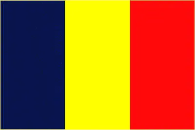 |
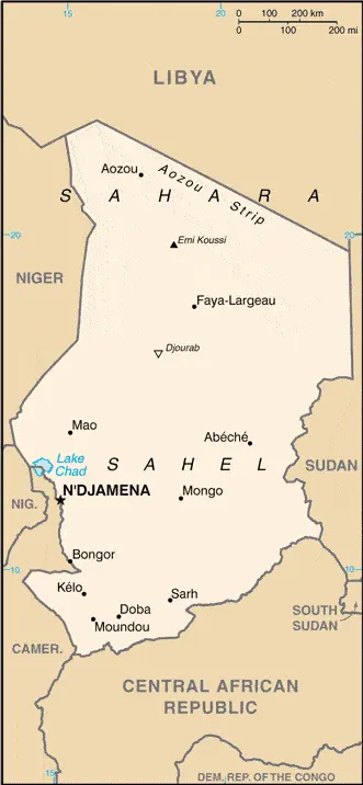
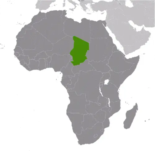
| Borderline map of Chad | Location map of Chad | Flag of Chad |
Google Maps and Detailed Facts of Chad (CD). This page lets you explore Chad and its border countries (Country Location: Central Africa, south of Libya) through detailed Satellite imagery – fast and easy as never before Google Maps.
Find comprehensive information about this country’s diversity below: Google Maps, geography, economy, science, people, culture, environment, government, and history – All in One Wiki page.
There is also a Street View and free Driving Directions at your service. Your Google Satellite Map Sightseeing in Chad, in Africa, starts here at Driving Directions and Maps.com.
Chad Google Maps & Satellite Maps
The map below shows Chad with its cities, towns, highways, main roads, streets, and Street Views. To find a location, use the form below, type any city or place, view a simple map, and click the “show map” button.
The Google Maps above shows Chad with its location: Africa (geographic coordinates: 15 00 N, 19 00 E) and the international borders of Chad; total: 6,406 km. Border countries (total: 6): Cameroon 1,116 km, Central African Republic 1,556 km, Libya 1,050 km, Niger 1,196 km, Nigeria 85 km, Sudan 1,403 km; furthermore, it’s inland counties boundaries.
Hint: Look at the Street view in Chad or Africa. All you have to do is drag and pull the little yellow man (named: Pegman) on the Google Maps above the desired location. After that, whenever it is available (more than 50 countries globally), blue stripes will appear to show the photos and details from Google’s regularly updated data image base. In case if you have signed in to your Google account currently, you may have a look at the satellite map of this country/area as well.
The map of Chad, Africa, is for informational use only. No representation is made or warrantied given any map or its content by Driving Directions and Maps site. The user assumes all risks of using this Chad Google Maps and facts/wiki.
About Chad in detail
Where is Chad?
Chad, in case, if you are looking on the map under the Coordinates 12 06 N 15 02 E otherwise in Africa, in Central Africa, south of Libya.
What is the capital city of Chad?
The capital city of Chad is N’Djamena.
What is the time in N’Djamena?
It is 6 hours ahead of Washington, D.C. during Standard Time; N’Djamena’s timezone is UTC+1.
What is the Internet code for Chad?
The Top Level Domain (TLD) for Chad is: .td
What is the size of Chad?
The territory of Chad is total: 1.284 million sq km; land: 1,259,200 sq km, water: 24,800 sq km.
If we want to describe the size of Chad’s territory is slightly more than three times the size of California.
If we would like to walk around and discover Chad, we can cover a total distance: 6,406 km.
What is the water coverage of Chad?
We have already mentioned what percentage of Chad is covered by water (see below), and this includes 0 km (landlocked country) coastline.
What is the climate like in Chad?
The climate of Chad is tropical in the south, desert in the north.
Geographical data of Chad
Chad’s elevation; mean elevation: 543 m, elevation extremes; lowest point: Djourab 160 m, highest point: Emi Koussi 3,415 m.
Chad’s specific geographical details include broad, arid plains in the center, desert in the north, mountains in the northwest, and lowlands in the south.
Suppose we would like to describe the countries location from a different perspective. In that case, it is safe to say, and easy to read from a map, Chad is note 1: Chad is the largest of Africa’s 16 landlocked countriesnote 2: not long ago – geologically speaking – what is today the Sahara was green savannah teeming with wildlife; during the African Humid Period, roughly 11,000 to 5,000 years ago, a vibrant animal community, including elephants, giraffes, hippos, and antelope lived there; the last remnant of the “Green Sahara” exists in the Lakes of Ounianga (oo-nee-ahn-ga) in northern Chad, a series of 18 interconnected freshwater, saline, and hypersaline lakes now protected as a World Heritage sitenote 3: Lake Chad, the most significant water body in the Sahel, is a remnant of a former inland sea, paleolake Mega-Chad; at its greatest extent, sometime before 5000 B.C., Lake Mega-Chad was the largest of four Saharan paleolakes that existed during the African Humid Period; it covered an area of about 400,000 sq km (150,000 sq mi), roughly the size of today’s Caspian Sea.
Resources and land use of Chad
The country’s main mined products are petroleum, uranium, natron, kaolin, fish (Lake Chad), gold, limestone, sand and gravel, salt. The population partly uses the earlier highlighted land territory and partly left in its natural state: agricultural land: 39.6%; arable land 3.9%; permanent crops 0%; permanent pasture 35.7%; forest: 9.1%; other: 51.3% (2011 estimate).
Population data of Chad
The number of inhabitants of Chad is 11,852,462 (July 2016 estimate).
If we examine the proportion of the population distribution, it is safe to say that population is unevenly distributed due to contrasts in climate and physical geography; the highest density is found in the southwest, particularly around Lake Chad and points south; the dry Saharan zone to the north is the least densely populated.
If we look at the proportion of the urbanized and barely populated areas, these are the figures: urban population: 22.5% of the total population (2015).
Most of Chad’s population is concentrated in N’DJAMENA (capital), 1.26 million (2015).
Ethnicity in Chad
According to ethnicity details, the ethnic groups are Sara (Ngambaye/Sara/Madjingaye/Mbaye) 25.9%, Arab 12.6%, Kanembu/Bornu/Buduma 8.3%, Wadai/Maba/Masalit/Mimi 7%, Gorane 6.8%, Masa/Musseye/Musgum 4.7%, Bulala/Medogo/Kuka 3.6%, Bidiyo/Migaama/Kenga/Dangleat 3.6%, Marba/Lele/Mesme 2.9%, Dadjo/Kibet/Muro 2.5%, Mundang 2.5%, Gabri/Kabalaye/Nanchere/Somrai 2.4%, Zaghawa/Bideyat/Kobe 2.3%, Fulani/Fulbe/Bodore 2%, Tupuri/Kera 2%, Tama/Assongori/Mararit 1.6%, Baguirmi/Barma 1.3%, Karo/Zime/Peve 1.3%, Mesmedje/Massalat/Kadjakse 1%, other Chadian ethnicities 2.5%, Chadians of foreign ethnicities 0.6%, foreign nationals 2.5% (Sudanese 2%) (2009 estimate).
The spoken languages in Chad are the following: French (official language), Arabic (official language), Sara (in the south), more than 120 different languages and dialects.
What are the most important religions in Chad?
According to this, during the general census, researchers examine the churches: Muslim 58.4%, Catholic 18.5%, Protestant 16.1%, animist 4%, other 0.5%, none 2.4% (2009 estimate).
Further population data of Chad
The proportion of gender and age tells a lot about the society as follows 0-14 years: 43.63% (male 2,622,700 / female 2,549,035) 15-24 years: 21.18% (male 1,225,731 / female 1,285,150) 25-54 years: 28.31% (male 1,525,208 / female 1,830,530) 55-64 years: 3.87% (male 202,044 / female 256,936) 65 years and over: 3% (male 146,957 / female 208,171) (2016 estimate). It also a significant factor in a society the population growth rate, which in the case of Chad is 1.88% (2016 estimate).
The population growth rate is based on two elements, the birth, and the death rate. In Chad the birth rate is 36.1 births / 1,000 population (2016 estimate), the death rate 14 deaths / 1,000 population (2016 estimate).
In this day and age in developed societies, the first child borns later compared to the previous centuries and decades, so childbearing is extended. In Chad, the average age of mothers at the first childbirth is N/A.
Although the children’s birth is postponed in the best-case scenario, the parents can still see their kids grow as life expectancy also extended. In the case of Chad, these figures are. With the introduction of modern medicine, vaccinations, and the proper hygienic conditions, the infant mortality rate is in a steep decline. The infant mortality statistics in Chad are the following: N/A. Relevant data is the budget of healthcare, which is in the case of this country is 3.6% of GDP (2014).
Economic data of Chad
Suppose we would like to describe a country. We also have to mention its economy; Chad’s landlocked location results in high transportation costs for imported goods and dependence on neighboring countries. Oil and agriculture are mainstays of Chad’s economy. Oil provides about 60% of export revenues, while cotton, cattle, livestock. Nearly all of Chad’s fuel is provided by one domestic refinery, and unanticipated shutdowns occasionally result in shortages. The country regulates the price of domestic fuel, providing an incentive for black market sales. Chad’s fiscal position is encumbered by declining oil prices, though high oil prices and strong local harvests supported the economy in recent years. Chad relies on foreign assistance and foreign capital for much public and private sector investment. Chad.
GDP is a prominent figure, as all the relevant calculations and statistics are based on it. GDP in Chad is $10.44 billion (2015 estimate).
Another important indicator is the rate of GDP growth, which in Chad is -1.1% (2016 estimate), 1.8% (2015 estimate) 6.9% (2014 estimate).
These statistics affect the world economy; remember, in 2015, the Chinese real GDP growth rate was worse than expected; The world markets fall, and the Chinese stock exchange is temporally suspended.
A further major factor of a country’s economy, the GDP per capita. In Chad this is $2,600 (2016 estimate) $2,700 (2015 estimate) $2,700 (2014 estimate).
In the economy, the Trinity is in common places, such as agriculture, industry, and services.
What are the agricultural products Chad produces?
Chad’s main agricultural products are cotton, sorghum, millet, peanuts, sesame, corn, rice, potatoes, onions, cassava (manioc, tapioca), cattle, sheep, goats, camels.
The essential segments are oil, cotton textiles, brewing, natron (sodium carbonate), soap, cigarettes, and construction materials. The crucial and regularly mentioned GDP is based on oil, cotton textiles, brewing, natron (sodium carbonate), soap, cigarettes, construction materials.
It is essential to mention that – thanks to the development of the infrastructure -, the rate of potable water improved: urban: 71.8% of the population, rural: 44.8% of the people, total: 50.8% of the community. Unimproved: urban: 28.2% of the people, rural: 55.2% of the population, total: 49.2% of the population (2015 estimate).
The average number of childbirth in Chad
In Chad, the average delivery number is 4.45 children born / woman (2016 estimate).
Population, median age, migration, and citizenship in Chad
The population’s average age is 17.6 years; male: 16.6 years, female: 18.6 years (2016 estimate). The age of adulthood varies in every country of the world. In Chad, it is 18 years of age, universal.
When we are experiencing an unprecedented scale of migration and globalization, it is an important factor in the number of new immigrants. In Chad is -3.3 migrant(s) / 1,000 population (2016 estimate). It is important to know how to apply for citizenship: citizenship by birth: no. Citizenship by descent only: both parents must be citizens of Chad. Dual citizenship recognized: Chadian law does not address—dual citizenship residency requirement for naturalization: 15 years.
Is Chad a safe destination? Healthcare services and infectious diseases in Chad
Many of the travelers are looking into the healthcare services and infectious diseases of their destinations. In Chad, the hospital beds’ density is N/A.
According to the WHO rating regarding contagious diseases in Chad, the degree of risk: very high food or waterborne diseases: bacterial and protozoal diarrhea, hepatitis A and E, and typhoid fever vectorborne diseases: malaria and dengue fever water contact disease: schistosomiasis respiratory disease: meningococcal meningitis animal contact disease: rabies (2016).
However, HIV is not curable but maintainable. Let’s do not forget when the disease surfaced; it was a world threatening condition. Unfortunately, in some countries, it is still very high the number of infected patients and fatalities due to the disease.
In Chad, the number of HIV/AIDS deaths: N/A.
Regarding tourism obesity, not an important issue, but we have to mention health statistics, as it is the plague of the 20th and the 21st century. The rate of obese adults in Chad is 6.6% (2014).
What are the natural hazards in Chad? Is there any?
The most known natural risk in Chad is hot. Dry, dusty harmattan winds occur in the north; periodic droughts; locust plagues.
More interesting facts about Chad
A few words about the past, as every country and society, is connected to its history; Chad, part of France‘s African holdings until 1960, endured three decades of civil warfare, as well as invasions by Libya before peace was restored in 1990. The government eventually drafted a democratic constitution and held flawed presidential elections in 1996 and 2001. In 1998, a rebellion broke out in northern Chad, sporadically flared up despite several peace agreements between the government and insurgents. In June 2005, President Idriss DEBY held a referendum successfully removing constitutional term limits and won another controversial election in 2006.
Sporadic rebel campaigns continued throughout 2006 and 2007. The capital experienced a significant insurrection in early 2008 but has had no significant rebel threats due to Chad’s 2010 rapprochement with Sudan, which previously used Chadian rebels as proxies. In late 2015, the government imposed a state of emergency in the Lake Chad region following multiple attacks by the terrorist group Boko Haram; Boko Haram also launched several bombings in N’Djamena in mid-2015. DEBY in 2011 was re-elected to his fourth term in an election that international observers described as proceeding without incident. In January 2014, Chad began a two-year rotation on the UN Security Council.
In every nation’s memory, some cornerstones placed the country on the timeline of history. The date of declaration of independence of Chad: 11 August 1960 (from France).
The flag and other symbols of Chad
The colors, symbols, and animals on the flag usually have a historical background or an important milestone or memory of the nation.
This case is not an exception, either. Three equal vertical bands of blue (hoist side), yellow, and red; the flag combines the blue and red French (former colonial) colors with the red and yellow of the Pan-African colors; blue symbolizes the sky, hope, and the south of the country, which is relatively well-watered; yellow represents the sun, as well as the desert in the north of the country; red stands for progress, unity, and sacrifice. Note: similar to the flag of Romania; also similar to the flags of Andorra and Moldova, both of which have a national coat of arms centered in the yellow band; the design was based on the flag of France.
Apart from the flag, the symbol of national unity is the national anthem. The anthem’s primary purpose is to share the nation’s core values, endeavors, and patriotic feelings.
National symbols of Chad: goat (north), lion (south); national colors: blue, yellow, red.
Constitution of Chad
The existence of the nation is based on the constitution. Some constitutions knew worldwide, like the U.S. Constitution that was accepted on the 17th of September 1787, in Philadelphia, the United States of America’s Constitution.
It is not related to the declaration of independence that was stolen by Nicolas Cage in the movie National Treasure 🙂
What is the legal system of Chad?
Most of the time, the legal system of a country is the focus of lawyers. It is a common fact that there are two main approaches in the world, “the law in books” and “the law in action.”
In the Anglo-Saxon world, the practice is the “law in action,” while in the rest of the world, the law is based on Roman law, the “law in books.”
The legal system of Chad is a mixed legal system of civil and customary law.
It was Aristotle who founded the Theory of 3 separations of powers. In his view, these are the council of public affairs, the magistrates, and the justice system. The age of enlightenment was the time when terminologies have defined the way we still use them. In most democratic countries, the three authorities separated from each other. In dictatorships, the rules usually interweaved in one hand.
About the legislative branch of Chad, we can highlight the following structures unicameral National Assembly (188 seats; 118 directly elected in multi-seat constituencies by proportional representation vote and 70 directly elected in single-seat constituencies by absolute majority vote with a second-round if needed; members serve 4-year terms).
About the unemployment rate, labor force, and poverty line in Chad
One of the major problems of the 21st-century economy is unemployment. Governments are struggling to maintain a low level of the unemployment rate. Still, as a result of automation, the cheap 3rd world labor, and the outsourcing of workflow, these attempts fail. In Chad, the labor force is 5.457 million (2016 estimate). Please bear in mind that the population in Chad is total: 87 deaths / 1,000 live births; male: 92.5 deaths / 1,000 live births, female: 81.3 deaths / 1,000 live births (2016 estimate) – as we already mentioned above.
The rate of unemployment in Chad is N/A %.
Widely known that the gap between the rich and poor is widening on an enormous scale.
According to the 2017 shocking Oxfam report, the most affluent eight people’s fortune is equal to the wealth of the poorest half of the world’s population.
In Chad, the households’ income and consumption compared to the entire population: lowest 10%: 2.6% highest 10%: 30.8% (2003).
Another widely used indicator is the so-called GINI index, which measures the inequalities of statistical dispersion, but is mainly used for measuring the sharing of income and fortune.
The GINI index was named after its founder Corrado Gini, an Italian economist. Gini index has grades between 0-1, but often it is used on a percentage basis. It is 0 if the examined criteria territorial distribution is equal. It is one of the criteria concentrated on the territory. In Chad, the GINI index is .43,3 (2011 estimate).
The states usually set up a poverty line, which is more or less, is a subjective measure. It varies by country; its base is often the minimum pension, the incomes of the most deficient 20 percent, the X percent of income per capita Etc.
In Chad, the poverty line people are the lowest 10%: 2.6% highest 10%: 30.8% (2003).
About the budget and central governments debt of Chad
The available budget mainly defines the state’s economy. Chad’s budget is; revenues: $1.626 billion, expenditures: $2.163 billion (2016 estimate). Taxes and other revenues are 15.6% of GDP (2016 estimate).
The budget deficit (Budget surplus (+) or deficit (-)) is N/A.
The fiscal year in Chad is the calendar year.
In the country’s economy, we have to consider the public debt. Public debt is the consolidated sum of the state’s local, federal, and central government debt.
Inflation rate and prime lending rate in Chad
A few further interesting and relevant economic data are the following; Inflation rate: 3.8% (2016 estimate), 4.6% (2015 estimate), and the rate of the Commercial bank prime lending rate: 15.5% (31 December 2016 estimate).
Export/import partners and data of Chad
Chad, with the export of products, industrial tools, and other services, generates revenue. The export value in Chad is: $4.053 billion (2016 estimate), $3.965 billion (2015 estimate). The total revenue of these activities: oil, livestock, cotton, sesame, gum arabic, shea butter.
Chad’s most important export partners are the United States 58.5%, India 13.3%, Japan 11.3%, China 4.1% (2015).
The most important imported products are machinery and transportation equipment, industrial goods, foodstuffs, textiles, and the countries from where the import is coming: France 16.5%, China 14.2%, Cameroon 11%, United States 6.4%, India 6%, Belgium 5.7%, Italy 4.8% (2015).
Renewable energies used in Chad
To suppress the pollution of the environment, renewable energies have to replace the fossil energy. The more the proportion of renewable energies in a country means more effort against pollution. Chad indicates how much of the country’s produced energy is coming from the hydroelectric source, 0% of total installed capacity (2012 estimate).
To indicate how much another renewable energy produced is 0% of total installed capacity (2012 estimate).
Telecommunication data of Chad, calling code
To maintain the economy, the development of a reliable and modern telecommunications infrastructure is crucial. We can say the following about Chad; an inadequate radiotelephone communication station system with high maintenance costs and low telephone density. Domestic: fixed-line connections for less than 1 per 100 persons coupled with mobile-cellular subscribership base of about 45 per 100 persons. International: country code – 235; satellite earth station – 1 Intelsat (Atlantic Ocean) (2015).
Transport infrastructure in Chad
In the 21st century, we often say that the world has become small and there are no distances anymore. With widespread air travel when (sometimes) there are no visa restrictions, it is easy to reach other countries, but if the distance is not too long, we can also use railway or water transportation.
The number of airports in Chad: 59 (2013), and the number of heliports: N/A.
The total length of the roadways in Chad: 40,000 km, note: consists of 25,000 km of national and regional roads and 15,000 km of local roads; 206 km of urban roads are paved (2011).
Chad’s waterways’ total length: (Chari and Legone Rivers are navigable only in the wet season) (2012).
Are you traveling to Chad?
If you plan to travel by plane to Chad, try our air ticket comparison site, where you can choose from hundreds of carriers and offers. Our application is scanning the market and shows you the best and the cheapest deals without any extra charge or commission.
Are you looking for a hotel, apartment another kind of accommodation in Chad, Africa? We are here to help you to find your accommodation from budget to luxury. Our search engine is scanning, regularly updating data from hundreds of accommodation websites and more than a million offers. You can quickly and easily find your hotel stay anywhere in the world, without any extra charge or commission.
Facts & data about Chad
Name of the country: conventional long way: the Republic of Chad, traditional short form: Chad, local long form: Republique du Tchad/Jumhuriyat Tshad, local short state: Tchad/Tshad, etymology: named for Lake Chad, which lies along the country’s western border; the word “tsade” means “large body of water” or “lake” in several local native languages.
| Abbreviation: Chad | Geographic coordinates: 15 00 N, 19 00 E |
Country Location: Africa |
| Capital of Chad: N’Djamena | GPS of the Capital: 12 06 N 15 02 E |
Position: Central Africa, south of Libya |
| Land area: total: 1.284 million sq km; land: 1,259,200 sq km, water: 24,800 sq km | Terrain: broad, arid plains in center, desert in north, mountains in northwest, lowlands in south |
Area comparative: slightly more than three times the size of California |
| Population: 11,852,462 (July 2016 estimate) | Population grow rate: 1.88% (2016 estimate) | Sex ratio: at birth: 1.04 male(s) / female, 0-14 years: 1.03 male(s) / female, 15-24 years: 0.95 male(s) / female, 25-54 years: 0.83 male(s) / female, 55-64 years: 0.79 male(s) / female, 65 years and over: 0.71 male(s) / female, total population: 0.93 male(s) / female (2016 estimate) |
| Exports: $4.053 billion (2016 estimate), $3.965 billion (2015 estimate) | Imports: $3.075 billion (2016 estimate), $3.071 billion (2015 estimate) | Import partners: France 16.5%, China 14.2%, Cameroon 11%, US 6.4%, India 6%, Belgium 5.7%, Italy 4.8% (2015) |
| Urbanization: urban population: 22.5% of the total population (2015) | Major urban area(s): N’DJAMENA (capital) 1.26 million (2015) | Median age: total: 17.6 years; male: 16.6 years, female: 18.6 years (2016 estimate) |
| Internet users: total: 314,000. Percent of the population: 2.7% (July 2015 estimate) | Telephones (fixed-lines): total subscriptions: 17,029. Subscriptions per 100 inhabitants: less than 1 (July 2015 estimate) | Telephones (mobile, cellular): total: 5.466 million. Subscriptions per 100 inhabitants: 47 (July 2015 estimate) |
| Unemployment rate: N/A % | Nationality: Chadian(s) adjective: Chadian | National holidays: Independence Day, 11 August (1960) |
| Life expectancy at birth: total population: 50.2 years. Male: 49 years, female: 51.5 years (2016 estimate) | Total fertility rate: 4.45 children born / woman (2016 estimate) | Birthrate: 36.1 births / 1,000 population (2016 estimate) |
| Literacy: age 15 and over can read and write French or Arabic. Total population: 40.2%; male: 48.5%, female: 31.9% (2015 estimate) | Legal system: mixed legal system of civil and customary law | Suffrage: 18 years of age, universal |
| Industries: oil, cotton textiles, brewing, natron (sodium carbonate), soap, cigarettes, construction materials | Industrial production growth rate: -5% (2016 estimate) | GDP real growth rate: -1.1% (2016 estimate) 1.8% (2015 estimate) 6.9% (2014 estimate) |
Do you like this Chad Google Maps & country information page?
Please do us a favor: Share or like this page using the icons at the top of the page. We also do encourage you to visit our Facebook page for more travel and country related information.
Many thanks for visiting and sharing this map & country information site!