Google Maps™ driving directions home » Middle East

Bahrain

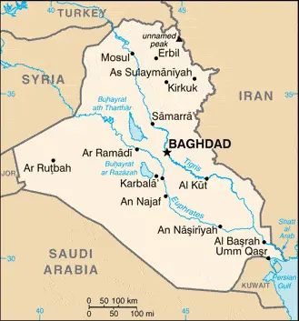
Driving Directions Bahrain

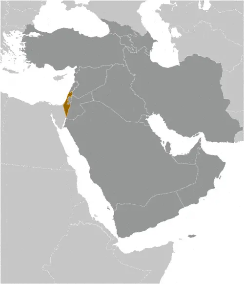
BAHRAIN, a small, oil-rich Emirate comprising 33 low-lying islands situated between the Qatar Peninsula and the mainland of Saudi Arabia, is a hereditary monarchy. The largest island is Bahrain Island, on which the capital, Manama (Al Manamah), is located. The King Fahd Causeway opened in 1986, links Bahrain Island to the mainland of Saudi Arabia. The highest point in the state is only 122 meters or 402 feet above sea level.

Read more

Google Maps™ driving directions home » Middle East

Bahrain Google Map

Google Maps and Detailed Facts of Bahrain (BH). This page lets you explore Bahrain and its border countries (Country Location: the Middle East, an archipelago in the Persian Gulf, east of Saudi Arabia) through detailed Satellite imagery – fast and easy as never before Google Maps.

Find comprehensive information about this country’s diversity below: Google maps, geography, economy, science, people, culture, environment, government, and history – All in One Wiki page.

There is also a Street View and free Driving Directions at your service. Your Google Satellite Map Sightseeing in Bahrain starts at Driving Directions And Maps.com in the Middle East.

Read more

Google Maps™ driving directions home » Middle East

Cyprus Google Map

This image shows the draft map of Cyprus, Middle East. For more details of the map of Cyprus, please see this page below. This image shows the location of Cyprus, Middle East. For more geographical details of Cyprus, please see this page below. This image shows the flag of Cyprus, Middle East. For more details of the flag of Cyprus, please see this page below.
Borderline map of Cyprus Location map of Cyprus Flag of Cyprus

Cyprus Google map

Google Maps and Detailed Facts of Cyprus (CY). This page lets you explore Cyprus and its border countries (Country Location: the Middle East, an island in the Mediterranean Sea, south of Turkey; note – Cyprus views itself as part of Europe; geopolitically, it can be classified as falling within Europe, the Middle East, or both) through detailed Satellite imagery – fast and easy as never before Google Maps.

Find comprehensive information about this country’s diversity below: Google maps, geography, economy, science, people, culture, environment, government, and history – All in One Wiki page.

There is also a Street View and free Driving Directions at your service. Your Google Satellite Map Sightseeing in Cyprus, in the Middle East, starts here at Driving Directions and Maps.com.

Read more

Google Maps™ driving directions home » Middle East

Gaza Strip Google Map

This image shows the draft map of Gaza Strip, Middle East. For more details of the map of Gaza Strip, please see this page below. This image shows the location of Gaza Strip, Middle East. For more geographical details of Gaza Strip, please see this page below. This image shows the flag of Gaza Strip, Middle East. For more details of the flag of Gaza Strip, please see this page below.
Borderline map of Gaza Strip Location map of Gaza Strip Flag of Gaza Strip

Gaza Strip Google map

Google Maps and Detailed Facts of the Gaza Strip (GZ). This page lets you explore Gaza Strip and its border countries (Country Location: the Middle East, bordering the Mediterranean Sea, between Egypt and Israel) through detailed Satellite imagery – fast and easy as never before Google Maps.

Find comprehensive information about this country’s diversity below: Google maps, geography, economy, science, people, culture, environment, government, and history – All in One Wiki page.

There is also a Street View and free Driving Directions at your service. Your Google Satellite Map Sightseeing in Gaza Strip starts here at Driving Directions and Maps.com in the Middle East.

Read more

Google Maps™ driving directions home » Middle East

Iran Google Map

This image shows the draft map of Iran, Middle East. For more details of the map of Iran, please see this page below. This image shows the location of Iran, Middle East. For more geographical details of Iran, please see this page below. This image shows the flag of Iran, Middle East. For more details of the flag of Iran, please see this page below.
Borderline map of Iran Location map of Iran Flag of Iran

Iran Google map

Google Maps and Detailed Facts of Iran (IR). This page lets you explore Iran and its border countries (Country Location: the Middle East, bordering the Gulf of Oman, the Persian Gulf, and the Caspian Sea, between Iraq and Pakistan) through detailed Satellite imagery – fast and easy as never before Google Maps.

Find comprehensive information about this country’s diversity below: Google maps, geography, economy, science, people, culture, environment, government, and history – All in One Wiki page.

There is also a Street View and free Driving Directions at your service. Your Google Satellite Map Sightseeing in Iran starts here at Driving Directions and Maps.com in the Middle East.

Read more

Google Maps™ driving directions home » Middle East

Iraq Google Map

This image shows the draft map of Iraq, Middle East. For more details of the map of Iraq, please see this page below. This image shows the location of Iraq, Middle East. For more geographical details of Iraq, please see this page below. This image shows the flag of Iraq, Middle East. For more details of the flag of Iraq, please see this page below.
Borderline map of Iraq Location map of Iraq Flag of Iraq

Iraq Google map

Google Maps and Detailed Facts of Iraq (IQ). This page lets you explore Iraq and its border countries (Country Location: the Middle East, bordering the Persian Gulf, between Iran and Kuwait) through detailed Satellite imagery – fast and easy as never before Google Maps.

Find comprehensive information about this country’s diversity below: Google maps, geography, economy, science, people, culture, environment, government, and history – All in One Wiki page.

There is also a Street View and free Driving Directions at your service. Your Google Satellite Map Sightseeing in Iraq, in the Middle East, starts here at Driving Directions and Maps.com.

Read more

Google Maps™ driving directions home » Middle East

Israel

Driving Directions Israel

ISRAEL is a republic created in 1948 after the British with­drawal from Palestine when the region was partitioned following a recommendation made by the United Nations. The new country was born into conflict, for the declaration of its existence by Jewish lead­ers led to immediate warfare with Arab neighbors – the first of five such Arablsraeli wars. Israel won this first war (and all others since) and, as a result, immediately acquired new territory beyond that envisaged by the United Nations.

Read more

Google Maps™ driving directions home » Middle East

Israel Google Map

This image shows the draft map of Israel, Middle East. For more details of the map of Israel, please see this page below. This image shows the location of Israel, Middle East. For more geographical details of Israel, please see this page below. This image shows the flag of Israel, Middle East. For more details of the flag of Israel, please see this page below.
Borderline map of Israel Location map of Israel Flag of Israel

Israel Google map

Google Maps and Detailed Facts of Israel (IL). This page lets you explore Israel and its border countries (Country Location: the Middle East, bordering the Mediterranean Sea, between Egypt and Lebanon) through detailed Satellite imagery – fast and easy as never before Google Maps.

Find comprehensive information about this country’s diversity below: Google maps, geography, economy, science, people, culture, environment, government, and history – All in One Wiki page.

There is also a Street View and free Driving Directions at your service. Your Google Satellite Map Sightseeing in Israel, in the Middle East, starts here at Driving Directions and Maps.com.

Read more

Google Maps™ driving directions home » Middle East

Jordan

Driving Directions Jordan

JORDAN is almost landlocked except for a short coastline on the Gulf of Aqaba. It is bounded by Saudi Arabia, Syria, Iraq, and Israel. Jordan is a predominantly arid country whose main topographical feature is a high, rugged plateau that rises on the River Jordan’s east side. It reaches elevations of over 1,500 meters or 4,000 feet in the south of the country and is dissected by steep-sided gorges.

The capital, Amman, is located at its northern end. The plateau loses height on its eastern side into a large area of semi-desert and desert. In general, summers are hot and dry, and winters cool and wet with variations related to altitude. The east has a desert climate.

Read more

Google Maps™ driving directions home » Middle East

Jordan Google Map

This image shows the draft map of Jordan, Middle East. For more details of the map of Jordan, please see this page below. This image shows the location of Jordan, Middle East. For more geographical details of Jordan, please see this page below. This image shows the flag of Jordan, Middle East. For more details of the flag of Jordan, please see this page below.
Borderline map of Jordan Location map of Jordan Flag of Jordan

Jordan Google map

Google Maps and Detailed Facts of Jordan (JO). This page lets you explore Jordan and its border countries (Country Location: Middle East, northwest of Saudi Arabia, between Israel (to the west) and Iraq) through detailed Satellite imagery – fast and easy as never before Google Maps.

Find comprehensive information about this country’s diversity below: Google maps, geography, economy, science, people, culture, environment, government, and history – All in One Wiki page.

There is also a Street View and free Driving Directions at your service. Your Google Satellite Map Sightseeing in Jordan starts here at Driving Directions and Maps.com in the Middle East.

Read more