
 |
 |
 |
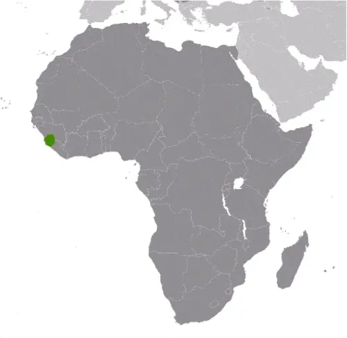
| Borderline map of Sierra Leone | Location map of Sierra Leone | Flag of Sierra Leone |
Google Maps and Detailed Facts of Sierra Leone (SL). This page lets you explore Sierra Leone and its border countries (Country Location: Western Africa, bordering the North Atlantic Ocean, between Guinea and Liberia) through detailed Satellite imagery – fast and easy as never before Google Maps.
Find comprehensive information about this country’s diversity below: Google Maps, geography, economy, science, people, culture, environment, government, and history – All in One Wiki page.
There is also a Street View and free Driving Directions at your service. In Africa, your Google Satellite Map Sightseeing in Sierra Leone starts here at Driving Directions and Maps.com.
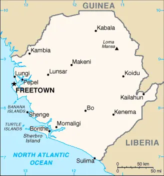
Sierra Leone Google Maps & Satellite Maps
The map below shows Sierra Leone with its cities, towns, highways, main roads, streets, and Street Views. To find a location, use the form below, type any city or place, view a simple map, and click the “show map” button.
The Google Maps above shows Sierra Leone with its location: Africa (geographic coordinates: 8 30 N, 11 30 W) and the international borders of Sierra Leone; total: 1,093 km. Border countries (total: 2): Guinea 794 km, Liberia 299 km; furthermore, it’s inland counties boundaries.
Hint: Look at the Street view in Sierra Leone, or Africa. All you have to do is drag and pull the little yellow man (named: Pegman) on the Google Maps above the desired location. After that, whenever it is available (more than 50 countries globally), blue stripes will appear to show the photos and details from Google’s regularly updated data image base. In case if you have signed in to your Google account currently, you may have a look at the satellite map of this country/area as well.
The map of Sierra Leone, Africa, is for informational use only. No representation is made or warrantied given any map or its content by Driving Directions and Maps site. The user assumes all risks of using this Sierra Leone Google Maps and facts/wiki.
About Sierra Leone in detail
Where is Sierra Leone?
In case, Sierra Leone is looking on the map under the Coordinates 8 29 N 13 14 W otherwise in Africa, in Western Africa, bordering the North Atlantic Ocean, between Guinea and Liberia.
What is the capital city of Sierra Leone?
The capital city of Sierra Leone is Freetown.
What is the time in Freetown?
It is 5 hours ahead of Washington, D.C. during Standard Time; the timezone of Freetown is UTC 0.
What is the Internet code for Sierra Leone?
The Top Level Domain (TLD) for Sierra Leone is: .sl
What is the size of Sierra Leone?
The territory of Sierra Leone is total: 71,740 sq km; land: 71,620 sq km, water: 120 sq km.
If we want to describe the size of the territory of Sierra Leone is somewhat smaller than South Carolina.
If we would like to walk around and discover Sierra Leone, we can cover a total distance: 1,093 km.
What is the water coverage of Sierra Leone?
We have already mentioned what percentage of Sierra Leone is covered by water (see below), including a 402 km coastline.
What is the climate like in Sierra Leone?
Sierra Leone’s climate is tropical: hot, humid: summer rainy season (May to December): winter dry season (December to April).
Geographical data of Sierra Leone
Sierra Leone’s elevation; mean elevation: 279 m, elevation extremes; lowest point: Atlantic Ocean 0 m, highest point: Loma Mansa 1,948 m.
The specific geographical details of Sierra Leone include a coastal belt of mangrove swamps, wooded hill country, upland plateau, mountains in the east.
Suppose we would like to describe the countries location from a different perspective. In that case, it is safe to say, and easy to read from a map, Sierra Leone is rainfall along the coast can reach 495 cm (195 inches) a year, making it one of the wettest places along with coastal, western Africa.
Resources and land use of Sierra Leone
The country’s main mined products are diamonds, titanium ore, bauxite, iron ore, gold, chromite. The population partly uses the earlier highlighted land territory and partly left in its natural state: agricultural land: 56.2%; arable land 23.4%; permanent crops 2.3%; permanent pasture 30.5%; forest: 37.5%; other: 6.3% (2011 estimate).
Population data of Sierra Leone
The number of inhabitants of Sierra Leone is 6,018,888 (July 2016 estimate).
If we examine the proportion of the population distribution, it is safe to say that N/A.
If we look at the proportion of the urbanized and barely populated areas, these are the figures: urban population: 39.9% of the total population (2015).
Most of Sierra Leone’s population is concentrated in FREETOWN (capital) 1.007 million (2015).
Ethnicity in Sierra Leone
According to ethnicity details, the ethnic groups are Temne 35%, Mende 31%, Limba 8%, Kono 5%, Kriole 2% (descendants of freed Jamaican slaves who were settled in the Freetown area in the late-18th century; also known as Krio), Mandingo 2%, Loko 2%, other 15% (includes refugees from Liberia’s recent civil war, and small numbers of Europeans, Lebanese, Pakistanis, and Indians) (2008 census).
Spoken languages in Sierra Leone
The spoken languages in Sierra Leone are the following: English (official language, regular use limited to literate minority), Mende (principal vernacular in the south), Temne (principal vernacular in the north), Krio (English-based Creole, spoken by the descendants of freed Jamaican slaves who were settled in the Freetown area, a lingua franca and the first language for 10% of the population but understood by 95%).
What are the most important religions in Sierra Leone?
According to this, during the general census, researchers examine the churches: Muslim 60%, Christian 10%, indigenous beliefs 30%.
Further population data of Sierra Leone
The proportion of gender and age tells a lot about the society as follows 0-14 years: 41.9% (male 1,257,997 / female 1,263,961) 15-24 years: 18.57% (male 542,975 / female 574,669) 25-54 years: 32.04% (male 924,331 / female 1,003,895) 55-64 years: 3.74% (male 104,415 / female 120,953) 65 years and over: 3.75% (male 94,520 / female 131,172) (2016 estimate). It also a significant factor in a society the population growth rate, which in the case of Sierra Leone is 2.36% (2016 estimate).
The population growth rate is based on two elements, the birth, and the death rate. In Sierra Leone the birth rate is 36.7 births / 1,000 population (2016 estimate), the death rate 10.6 deaths / 1,000 population (2016 estimate).
In this day and age in developed societies, the first child borns later compared to the previous centuries and decades, so childbearing is extended. In Sierra Leone, the average age of mothers at the first childbirth is N/A.
Although the children’s birth is postponed in the best-case scenario, the parents can still see their kids grow as life expectancy also extended. In the case of Sierra Leone, these figures are. With the introduction of modern medicine, vaccinations, and the proper hygienic conditions, the infant mortality rate is in a steep decline. The infant mortality statistics in Sierra Leone are the following: N/A. Relevant data is the budget of healthcare, which is in the case of this country is 11.1% of GDP (2014).
Economic data of Sierra Leone
Suppose we would like to describe a country. We also have to mention its economy; Sierra Leone is extremely poor, and nearly half of the working-age population engages in subsistence agriculture. The country possesses substantial mineral, agricultural, and fishery resources, but it is still recovering from a civil war. In recent years economic growth has been driven by mining – particularly iron ore. The country’s principal exports are iron ore, diamonds, and rutile, and the economy is vulnerable to fluctuations in international prices. While the World Health Organization declared an end to the Ebola outbreak in Sierra Leone in November 2015, economic recovery will depend on rising commodities prices and increased efforts to diversify growth sources.
GDP is a prominent figure, as all the relevant calculations and statistics are based on it. GDP in Sierra Leone is $4.289 billion (2015 estimate).
Another important indicator is the rate of GDP growth, which in Sierra Leone is 4.3% (2016 estimate) -21.1% (2015 estimate) 4.6% (2014 estimate).
These statistics affect the world economy; remember, in 2015, the Chinese real GDP growth rate was worse than expected; The world markets fall, and the Chinese stock exchange was temporarily suspended.
A further major factor of a country’s economy, the GDP per capita. In Sierra Leone this is $1,700 (2016 estimate) $1,600 (2015 estimate) $2,100 (2014 estimate).
In the economy, the Trinity is in common places, such as agriculture, industry, and services.
What are the agricultural products Sierra Leone produces?
The main agricultural products of Sierra Leone are rice, coffee, cocoa, palm kernels, palm oil, peanuts, cashews, poultry, cattle, sheep, pigs; fish.
The essential segments are diamond mining; iron ore, rutile and bauxite mining; small-scale manufacturing (beverages, textiles, footwear). The crucial and regularly mentioned GDP is based on diamond mining; iron ore, rutile, and bauxite mining; small-scale manufacturing (beverages, textiles, footwear).
Drinking water source in Sierra Leone
It is essential to mention that – thanks to the development of the infrastructure -, the rate of potable water improved: urban: 84.9% of the population, rural: 47.8% of the people, total: 62.6% of the population. Unimproved: urban: 15.1% of the people, rural: 52.2% of the people, total: 37.4% of the population (2015 estimate).
The average number of childbirth in Sierra Leone
In Sierra Leone, the average delivery number is 4.76 children born / woman (2016 estimate).
Population, median age, migration, and citizenship in Sierra Leone
The population’s average age is 19 years; male: 18.4 years, female: 19.6 years (2016 estimate). The age of adulthood varies in every country of the world in Sierra Leone; it is 18 years of age, universal.
When we are experiencing an unprecedented scale of migration and globalization, it is an important factor in the number of new immigrants. In Sierra Leone is -2.4 migrant(s) / 1,000 population (2016 estimate). It is important to know how to apply for citizenship: citizenship by birth: no. Citizenship by descent only: at least one parent or grandparent must be a citizen of Sierra Leone. Dual citizenship recognized: yes, the residency requirement for naturalization: 5 years.
Is Sierra Leone a safe destination? Healthcare services and infectious diseases in Sierra Leone
Many of the travelers are looking into the healthcare services and infectious diseases of their destinations. In Sierra Leone, the hospital beds’ density is 0.4 beds / 1,000 population (2006).
According to the WHO rating regarding contagious diseases in Sierra Leone, the degree of risk: very high food or waterborne diseases: bacterial and protozoal diarrhea, hepatitis A, and typhoid fever vectorborne diseases: malaria, dengue fever, and yellow fever water contact disease: schistosomiasis. Animal contact disease: rabies. Aerosolized dust or soil contact disease: Lassa fever (2016).
However, HIV is not curable but maintainable. Let’s do not forget when the disease surfaced; it was a world threatening condition. Unfortunately, in some countries, it is still very high the number of infected patients and fatalities due to the disease.
In Sierra Leone, the number of HIV/AIDS deaths: N/A.
Regarding tourism obesity, not an important issue, but we have to mention health statistics, as it is the plague of the 20th and the 21st century. The rate of obese adults in Sierra Leone is 6.6% (2014).
What are the natural hazards in Sierra Leone? Is there any?
The most known natural risk in Sierra Leone are dry, sand-laden harmattan winds blow from the Sahara (December to February); sandstorms, dust storms.
More interesting facts about Sierra Leone
A few words about the past, as every country and society is connected to its history; The British set up a trading post near present-day Freetown in the 17th century. Initially, the trade involved timber and ivory, but later it expanded into slaves. Following the American Revolution, a colony was established in 1787, and Sierra Leone became a destination for resettling black loyalists who had originally been resettled in Nova Scotia. After abolishing the slave trade in 1807, British crews delivered thousands of Africans liberated from illegal slave ships to Sierra Leone, particularly Freetown. The colony gradually expanded inland during the course of the 19th century; independence was attained in 1961.
Democracy is slowly being reestablished after the civil war (1991-2002), resulting in tens of thousands of deaths and the displacement of more than 2 million people (about one-third of the population). The military, which took over full responsibility for security following UN peacekeepers’ departure at the end of 2005, has developed as a guarantor of the country’s stability; the armed forces remained on the sideline during the 2007 and 2012 national elections. In March 2014, the UN Integrated Peacebuilding Office’s closure in Sierra Leone marked the end of more than 15 years of peacekeeping and political operations in Sierra Leone. The government’s stated priorities include furthering development – including recovering from the Ebola epidemic – creating jobs, and stamping out endemic corruption.
In every nation’s memory, some cornerstones placed the country on the timeline of history. The date of declaration of independence of Sierra Leone: 27 April 1961 (from the UK).
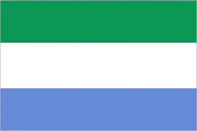
The flag and other symbols of Sierra Leone
The colors, symbols, and animals on the flag usually have a historical background or an important milestone or memory of the nation.
This case is not an exception either; three equal horizontal bands of green (top), white, and blue; green symbolizes agriculture, mountains, and natural resources, white represents unity and justice, and blue the sea and the natural harbor in Freetown.
Apart from the flag, the symbol of national unity is the national anthem. The anthem’s primary purpose is to share the nation’s core values, endeavors, and patriotic feelings.
National symbols of Sierra Leone: lion; national colors: green, white, blue.
Constitution of Sierra Leone
The existence of the nation is based on the constitution. Some constitutions knew worldwide, like the U.S. Constitution that was accepted on the 17th of September 1787, in Philadelphia, the United States of America’s Constitution.
It is not related to the declaration of independence that was stolen by Nicolas Cage in the movie National Treasure 🙂
What is the legal system of Sierra Leone?
Most of the time, the legal system of a country is the focus of lawyers. It is a common fact that there are two main approaches in the world, “the law in books” and “the law in action.”
In the Anglo-Saxon world, the practice is the “law in action,” while in the rest of the world, the law is based on Roman law, the “law in books.”
The legal system of Sierra Leone is a mixed legal system of English common law and customary law.
It was Aristotle who founded the Theory of 3 separations of powers. In his view, these are the council of public affairs, the magistrates, and the justice system. The age of enlightenment was the time when terminologies have defined the way we still use them. In most democratic countries, the three authorities separated from each other. In dictatorships, the rules usually interweaved in one hand.
About the legislative branch of Sierra Leone, we can highlight the following structures unicameral Parliament (124 seats; 112 members directly elected in single-seat constituencies by simple majority vote and 12 seats filled in separate elections by non-partisan members of Parliament called “paramount chiefs;” members serve 5-year terms).
About the unemployment rate, labor force, and poverty line in Sierra Leone
One of the major problems of the 21st-century economy is unemployment. Governments are struggling to maintain a low level of the unemployment rate. Still, as a result of automation, the cheap 3rd world labor, and the outsourcing of workflow, these attempts fail. In Sierra Leone, the labor force is 2.678 million (2016 estimate). Please bear in mind that the population in Sierra Leone is total: 70 deaths / 1,000 live births; male: 78.4 deaths / 1,000 live births, female: 61.4 deaths / 1,000 live births (2016 estimate) – as we already mentioned above.
The rate of unemployment in Sierra Leone is 9.1% (2014 estimate).
Widely known that the gap between the rich and poor is widening on an enormous scale.
According to the 2017 shocking Oxfam report, the most affluent eight people’s fortune is equal to the wealth of the poorest half of the world’s population.
In Sierra Leone, the households’ income and consumption compared to the entire population: lowest 10%: 2.6% highest 10%: 33.6% (2003).
Another widely used indicator is the so-called GINI index, which measures the inequalities of statistical dispersion, but is mainly used for measuring the sharing of income and fortune.
The GINI index was named after its founder Corrado Gini, an Italian economist. Gini index has grades between 0-1, but often it is used on a percentage basis. It is 0 if the examined criteria territorial distribution is equal. It is one of the criteria concentrated on the territory. In Sierra Leone, the GINI index is .34 (2011).
The states usually set up a poverty line, which is more or less, is a subjective measure. It varies by country; its base is often the minimum pension, the incomes of the most deficient 20 percent, the X percent of income per capita Etc.
In Sierra Leone, the poverty line people are the lowest 10%: 2.6% highest 10%: 33.6% (2003).
About the budget and central governments debt of Sierra Leone
The available budget mainly defines the state’s economy. Sierra Leone’s budget is; revenues: $558.1 million, expenditures: $738.6 million (2016 estimate). Taxes and other revenues are 13% of the GDP (2016 estimate).
The budget deficit (Budget surplus (+) or deficit (-)) is N/A.
The fiscal year in Sierra Leone is the calendar year.
In the country’s economy, we have to consider the public debt. Public debt is the consolidated sum of the state’s local, federal, and central government debt.
Inflation rate and prime lending rate in Sierra Leone
A few further interesting and relevant economic data are the following; Inflation rate: 7.1% (2016 estimate), 8% (2015 estimate), and the rate of the Commercial bank prime lending rate: 18.9% (31 December 2016 estimate).
Export/import partners and data of Sierra Leone
Sierra Leone, with the export of products, industrial tools, and other services, generates revenue. The export value in Sierra Leone is $886.4 million (2016 estimate), $569.4 million (2015 estimate). These activities’ total revenue: Iron ore, diamonds, rutile, cocoa, coffee, fish.
The most important export partners of Sierra Leone are China 31.3%, Belgium 27.8%, Romania 11.3%, the US 7.3%, India 4% (2015).
The most important imported products are foodstuffs, machinery and equipment, fuels and lubricants, chemicals, and the countries where the import is coming: China 23%, India 7.9%, US 6.4%, Netherlands 5.1% (2015).
Renewable energies used in Sierra Leone
To suppress the pollution of the environment, renewable energies have to replace the fossil energy. The more the proportion of renewable energies in a country means more effort against pollution. Sierra Leone, the indicator of how much of the country’s produced energy is coming from the hydroelectric source, is 66.7% of total installed capacity (2012 estimate).
To indicate how much another renewable energy produced is 0% of total installed capacity (2012 estimate).
Telecommunication data of Sierra Leone, calling code
To maintain the economy, the development of a reliable and modern telecommunications infrastructure is crucial. We can say the following about Sierra Leone; marginal telephone service with poor infrastructure. Domestic: the national microwave radio relay trunk system connects Freetown to Bo and Kenema; while mobile-cellular service is growing rapidly from a small base, service area coverage remains limited. International: country code – 232; satellite earth station – 1 Intelsat (Atlantic Ocean) (2010).
Transport infrastructure in Sierra Leone
In the 21st century, we often say that the world has become small and there are no distances anymore. With widespread air travel when (sometimes) there are no visa restrictions, it is easy to reach other countries, but if the distance is not too long, we can also use railway or water transportation.
The number of airports in Sierra Leone: 8 (2013), and the number of heliports: 2 (2013).
The total length of the roadways in Sierra Leone: total: 11,300 km, paved: 904 km, unpaved: 10,396 km (2002).
The waterways’ total length in Sierra Leone is 800 km (600 km navigable year-round) (2011).
Are you traveling to Sierra Leone?
If you plan to travel by plane to Sierra Leone, try our air ticket comparison site, where you can choose from hundreds of carriers and offers. Our application is scanning the market and shows you the best and the cheapest deals without any extra charge or commission.
Are you looking for a hotel, apartment another kind of accommodation in Sierra Leone, Africa? We are here to help you to find your accommodation from budget to luxury. Our search engine is scanning, regularly updating data from hundreds of accommodation websites and more than a million offers. You can quickly and easily find your hotel stay anywhere in the world, without any extra charge or commission.
Facts & data about Sierra Leone
Name of the country: conventional long way: the Republic of Sierra Leone, traditional short form: Sierra Leone, local long form: the Republic of Sierra Leone, local short state: Sierra Leone, etymology: the Portuguese explorer Pedro de SINTRA named the country “Serra Leoa” (Lion Mountains) for the impressive mountains he saw while sailing the West African coast in 1462.
| Abbreviation: Sierra Leone | Geographic coordinates: 8 30 N, 11 30 W |
Country Location: Africa |
| Capital of Sierra Leone: Freetown | GPS of the Capital: 8 29 N 13 14 W |
Position: Western Africa, bordering the North Atlantic Ocean, between Guinea and Liberia |
| Land area: total: 71,740 sq km; land: 71,620 sq km, water: 120 sq km | Terrain: coastal belt of mangrove swamps, wooded hill country, upland plateau, mountains in east |
Area comparative: somewhat smaller than South Carolina |
| Population: 6,018,888 (July 2016 estimate) | Population grow rate: 2.36% (2016 estimate) | Sex ratio: at birth: 1.03 male(s) / female, 0-14 years: 1 male(s) / female, 15-24 years: 0.94 male(s) / female, 25-54 years: 0.92 male(s) / female, 55-64 years: 0.86 male(s) / female, 65 years and over: 0.73 male(s) / female, total population: 0.95 male(s) / female (2016 estimate) |
| Exports: $886.4 million (2016 estimate), $569.4 million (2015 estimate) | Imports: $1.303 billion (2016 estimate), $1.575 billion (2015 estimate) | Import partners: China 23%, India 7.9%, US 6.4%, Netherlands 5.1% (2015) |
| Urbanization: urban population: 39.9% of the total population (2015) | Major urban area(s): FREETOWN (capital) 1.007 million (2015) | Median age: total: 19 years; male: 18.4 years, female: 19.6 years (2016 estimate) |
| Internet users: total: 147,000. Percent of the population: 2.5% (July 2015 estimate) | Telephones (fixed-lines): total subscriptions: 17,000. Subscriptions per 100 inhabitants: less than 1 (July 2015 estimate) | Telephones (mobile, cellular): total: 5.657 million. Subscriptions per 100 inhabitants: 96 (July 2015 estimate) |
| Unemployment rate: 9.1% (2014 estimate) | Nationality: Sierra Leonean(s) adjective: Sierra Leonean | National holidays: Independence Day, 27 April (1961) |
| Life expectancy at birth: total population: 58.2 years. Male: 55.6 years, female: 60.9 years (2016 estimate) | Total fertility rate: 4.76 children born / woman (2016 estimate) | Birthrate: 36.7 births / 1,000 population (2016 estimate) |
| Literacy: age 15 and over can read and write English, Mende, Temne, or Arabictotal population: 48.1%; male: 58.7%, female: 37.7% (2015 estimate) | Legal system: mixed legal system of English common law and customary law | Suffrage: 18 years of age, universal |
| Industries: diamond mining; iron ore, rutile and bauxite mining; small-scale manufacturing (beverages, textiles, footwear) | Industrial production growth rate: 14% (2016 estimate) | GDP real growth rate: 4.3% (2016 estimate) -21.1% (2015 estimate) 4.6% (2014 estimate) |
Do you like this Sierra Leone Google Maps & country information page?
Please do us a favor: Share or like this page using the icons at the top of the page. We also do encourage you to visit our Facebook page for more travel and country related information.
Many thanks for visiting and sharing this map & country information site!