Explore the countries in Asia with all their Wiki, find information on weather, population, facts, history, landmarks of major cities data, and enjoy free Google maps Satellite imagery & Street views. Each Country Profile in Asia provides information on Geography data, area maps, Google maps, flag, history, area, population, the capital city, largest cities, economy, spoken languages, ethnicity/race, religion, literacy rate, government, and many more!
In this map category, you will find these Asian countries and their capital cities:
BELARUS (Belorussia, Byelorussia), a republic of the former USSR, declared itself independent in 1991. It borders Poland to the west, Ukraine to the south, Latvia and Lithuania to the north, and Russia to the east. The country consists mainly of a low-lying plain, and forests cover approximately one-third of the country.
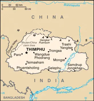
India surrounds BHUTAN to the south and China to the north. It rises from foothills overlooking the Brahmaputra river to the southern slopes of the Himalayas. The Himalayas, which rise to over 7,500 meters or 24,608 feet in Bhutan, make up most countries. Bhutan can be divided into three topographical regions: the high Himalayas; the middle Himalayas, where the mountains are lower and are dissected by fertile valleys occupied by rivers which are main tributaries of India’s Brahmaputra river; and the foothills and plains of a region called the Duars, the southern part of which is used for agriculture.
Google Maps and Detailed Facts of Bhutan (BT). This page lets you explore Bhutan and its border countries (Country Location: Southern Asia, China, and India) through detailed Satellite imagery – fast and easy as never before Google Maps.
Find comprehensive information about this country’s diversity below: Google maps, geography, economy, science, people, culture, environment, government, and history – All in One Wiki page.
There is also a Street View and free Driving Directions at your service. Your Google Satellite Map Sightseeing in Bhutan, in Asia, starts here at Driving Directions and Maps.com.
Bishkek is one of the most populated cities in Kyrgyzstan, and at the same time, this city is the capital of this country. Located in Asia, you may find the city easily with the following GPS coordinates: 42.54N latitude / 74.46E longitude. For routing in Bishkek, please check the free driving directions Bishkek service below.
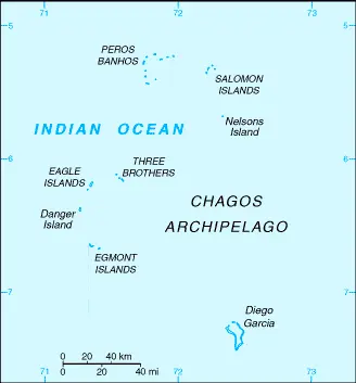
Formerly part of the British Crown Colony of Mauritius, the British Indian Ocean Territory (BIOT) became a UK overseas territory in 1965. Some islands were later transferred to the Seychelles when it gained independence in 1976. Since then, BIOT has only consisted of the six main groups in the Chagos Archipelago. The largest and most southerly island, Diego Garcia, is inhabited and serves as a joint UK-US naval support facility. It also hosts one of four dedicated ground antennas for operating the Global Positioning System (GPS). The US Air Force has a telescope array on Diego Garcia as part of the Ground-Based Electro-Optical Deep Space Surveillance System (GEODSS), which tracks orbital debris that can be dangerous to spacecraft and astronauts.
BRUNEI is a sultanate located on the northwest coast of the island of Borneo in Southeast Asia. It is bounded on all sides by the Malaysian state of Sarawak, which splits the country into two separate parts. Broad tidal swamplands cover the coastal plains, and inland Brunei is hilly and covered with tropical rainforests.
CAMBODIA, formerly called Kampuchea, is a southeast Asian state bounded by Thailand, Laos, and Vietnam, and its southern coast lies on the Gulf of Thailand. The country was devastated by its involvement in the Vietnam War (1960-75), followed by the brutal regime of the Khymer Rouge under Pol Pot (1975-79) when it thought that as many as two million people were killed. Since that time, extreme political instability and sporadic fighting have hampered development within the country. Cambodia is largely a low-lying country fringed by modest-sized mountain ranges and upland plateaux in the southwest, north, and east. The Dangrek Mountains form the frontier with Thailand in the northwest. The heart of the country is the Mekong River drains a saucer-shaped basin whose gently rolling alluvial plains. The western part of the basin is occupied by a large lake, the Tónié Sap (Great Lake).
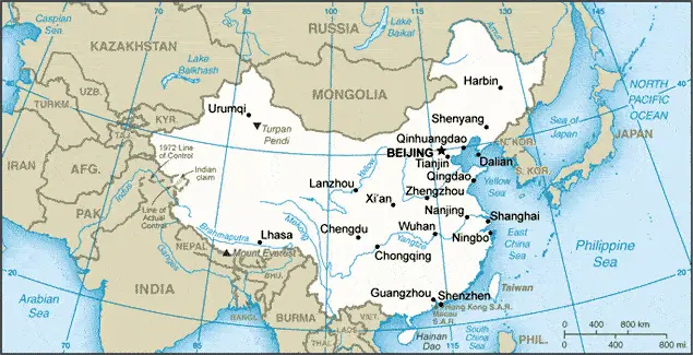
CHINA or THE PEOPLE’S REPUBLIC OF CHINA dominates the region of East Asia, not only regarding size since it is the third-largest country in the world but also because of its vast population. One-fifth of the world’s people (numbering approximately 1,393,741,000 ) live in China, and it has a larger population than any other individual country. The area occupied by China includes about 3,400 islands but excludes the disputed territory of Taiwan. The People’s Republic shares borders with many other countries: Vietnam, Laos, Myanmar (Burma), India, Bhutan, Nepal, Pakistan, Afghanistan, Tajikistan, Kyrgyzstan, Kazakhstan, Mongolia, Russia, and North Korea. In the east, China has an extensive coastline with the Yellow Sea, the East China Sea, and the South China Sea, all of which open into the Pacific Ocean.
Google Maps and Detailed Facts of China (CH). This page lets you explore China and its border countries (Country Location: Eastern Asia, bordering the East China Sea, Korea Bay, Yellow Sea, and the South China Sea, between North Korea and Vietnam) through detailed Satellite imagery – fast and easy as never before Google Maps.
Find comprehensive information about this country’s diversity below: Google maps, geography, economy, science, people, culture, environment, government, and history – All in One Wiki page.
There is also a Street View and free Driving Directions at your service. Your Google Satellite Map Sightseeing in China, in Asia, starts here at Driving Directions and Maps.com.
Colombo is one of the most populated cities in Sri Lanka, and at the same time, this city is the capital of this country. Located in Asia, you may find the city easily with the following GPS coordinates: 6.92N latitude / 79.86E longitude. For routing in Colombo, please check the free driving directions Colombo service below.
This website uses cookies to improve your experience. AcceptRead More
Privacy & Cookies Policy
Privacy Overview
This website uses cookies to improve your experience while you navigate through the website. Out of these, the cookies that are categorized as necessary are stored on your browser as they are essential for the working of basic functionalities of the website. We also use third-party cookies that help us analyze and understand how you use this website. These cookies will be stored in your browser only with your consent. You also have the option to opt-out of these cookies. But opting out of some of these cookies may affect your browsing experience.
Necessary cookies are absolutely essential for the website to function properly. This category only includes cookies that ensures basic functionalities and security features of the website. These cookies do not store any personal information.
Any cookies that may not be particularly necessary for the website to function and is used specifically to collect user personal data via analytics, ads, other embedded contents are termed as non-necessary cookies. It is mandatory to procure user consent prior to running these cookies on your website.