
Google Maps and Detailed Facts of Bhutan (BT). This page lets you explore Bhutan and its border countries (Country Location: Southern Asia, China, and India) through detailed Satellite imagery – fast and easy as never before Google Maps.
Find comprehensive information about this country’s diversity below: Google Maps, geography, economy, science, people, culture, environment, government, and history – All in One Wiki page.
There is also a Street View and free Driving Directions at your service. Your Google Satellite Map Sightseeing in Bhutan, in Asia, starts here at Driving Directions and Maps.com.
About Bhutan in detail
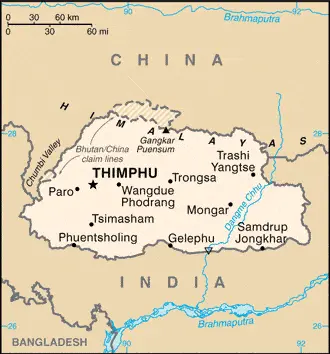
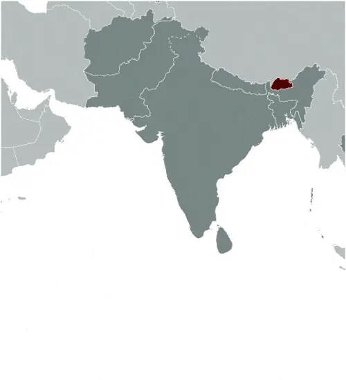
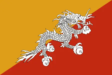
Table of contents
- Background
- Overview
- Google Maps
- Climate
- Geography
- Resources and Land Use
- Population Data
- Economic Data
- Drinking Water Source
- Population, Median Age, Migration, and Citizenship
- Average Number of Childbirths
- Is this country a Safe Destination?
- Healthcare and Infectious Diseases
- Natural Hazards
- The Flag and Other Symbols
- Constitution
- Legal System
- About the Unemployment Rate, Labor Force, and Poverty Line
- About the Budget and Central Government Debt
- Inflation Rate and Prime Lending Rate
- Export/Import Partners and Data
- Renewable Energies Used
- Telecommunication Data, Calling Code
- Transport Infrastructure
- More Interesting Facts
Background
Bhutan, a small country in the Himalayas between China and India, has a unique history. After Britain’s victory in the 1865 Duar War, Bhutan signed the Treaty of Sinchulu with Britain, receiving an annual subsidy in exchange for ceding land. Ugyen Wangchuck, who became king in 1907, led Bhutan to its modern era. The 1949 Indo-Bhutanese Treaty of Friendship returned some territory to Bhutan and formalized subsidies from India. Bhutan’s progressive opening to the world started in the 1950s, with Bhutan joining the UN in 1971. The first democratic constitution was introduced in 2005, leading to the first parliamentary election 2008.
Overview
Situated in Southern Asia, Bhutan covers an area of 38,394 sq km, slightly larger than Maryland. Its terrain is mostly mountainous, with some fertile valleys and savanna. Bhutan’s climate varies from tropical in the south to cool winters and hot summers in the central valleys and severe winters with cool summers in the Himalayas. The country’s population is approximately 876,181 (2023 est.), with a blend of Ngalop, ethnic Nepali, and indigenous tribes. Bhutan is known for its Gross National Happiness policy, prioritizing its citizens’ well-being over economic growth.
Official Name: Kingdom of Bhutan
Date of Formation: 17 December 1907 (became a unified kingdom under its first hereditary king); 8 August 1949 (Treaty of Friendship with India maintains Bhutanese independence)
Capital: Thimphu
Population: 876,181 (2023 est.)
Total Area: 14,824 Sq. Miles / 38,394 Sq. Km
Population Density: N/A
Languages: Sharchopkha 28%, Dzongkha (official) 24%, Lhotshamkha 22%, other 26% (includes foreign languages) (2005 est.)
Religions: Lamaistic Buddhist 75.3%, Indian- and Nepali-influenced Hinduism 22.1%, other 2.6% (2005 est.)
Ethnic Origin: Ngalop (also known as Bhote) 50%, ethnic Nepali 35% (predominantly Lhotshampas), indigenous or migrant tribes 15%
Government: Constitutional monarchy
Currency: Ngultrum (BTN)
Literacy Rate: 70.9% (2021 est.)
Calorie Consumption: N/A
Google Maps
Google Maps is a valuable tool for navigating Bhutan’s rugged terrain, offering detailed maps that help explore its scenic monasteries, traditional villages, and mountainous landscapes. It provides vital geographic information for visitors and residents of this secluded Himalayan kingdom.
Perched in the eastern Himalayas between India and China lies the landlocked Kingdom of Bhutan. It is largely closed to the outside world to protect its culture; TV was banned until 1999. Low, tropical southern strip rising through fertile central valleys to the high Himalayas in the north. Around 70% of the land is forested.
The map below shows Bhutan’s cities, towns, highways, main roads, streets, and Street Views. To find a location, use the form below, type any city or place, view a simple map, and click the “show map” button.
The Google Maps above shows Bhutan with its location: Asia (geographic coordinates: 27 30 N, 90 30 E) and the international borders of Bhutan; total: 1,136 km. Border countries (total: 2): China is 477 km, India is 659 km; furthermore, it’s inland counties boundaries.
The map of Bhutan, Asia, is for informational use only. No representation is made or warranted given any map or content by the Driving Directions and Maps site. The user assumes all risks of using this Bhutan Google Maps and facts/wiki.
Climate
Bhutan’s climate is remarkably varied due to its geographical diversity and elevation range. From the tropical southern plains to the cool central valleys and the harsh conditions of the Himalayan regions, each area experiences distinct climatic conditions, impacting agriculture, wildlife, and the day-to-day lives of the Bhutanese people.
- Tropical Southern Plains: The climate is predominantly tropical in the southern plains, with high humidity and heavy rainfall. This region experiences hot summers, often exceeding 30°C (86°F). Winters are cool and pleasant, with average temperatures hovering around 15°C (59°F). This area receives the heaviest rainfall in the country, primarily during the monsoon season from June to September, significantly influencing agricultural practices, such as rice cultivation and various tropical fruits.
- Cool Central Valleys: The central valleys of Bhutan, including the capital, Thimphu, experience a temperate climate with cool winters and warm summers. Winter temperatures in these regions can drop to around 0°C (32°F) and occasionally lower, especially at night. Summer temperatures, on the other hand, can rise to 25°C (77°F) or more. This climatic zone receives moderate rainfall, mostly concentrated in the summer months. The central valleys are known for their diverse agricultural produce, including wheat, apples, and potatoes.
- Harsh Himalayan Regions: The high Himalayan regions of Bhutan face much more severe climatic conditions. Winters are harsh, with heavy snowfall and temperatures that can plummet well below freezing, sometimes reaching -10°C (14°F) or lower. Summers are cool, with average temperatures ranging between 10°C to 15°C (50°F to 59°F). These areas are sparsely populated due to extreme weather and limited agriculture. However, this region has unique alpine flora and fauna, including the elusive snow leopard and the Himalayan blue poppy, Bhutan’s national flower.
- Impact on Agriculture and Daily Life: The diverse climate across Bhutan plays a pivotal role in determining agricultural practices. While rice is the staple in the warmer southern plains, barley, wheat, and potatoes are more common in the cooler central and northern regions. The climatic conditions also influence the traditional Bhutanese lifestyle, including clothing, housing, and food habits, which vary significantly from the warm south to the cold north.
- Environmental Challenges and Conservation Efforts: Bhutan faces various environmental challenges, including the threat of climate change, which could lead to glacial melting and impact water resources. The country is, however, a global leader in environmental conservation, being one of the few carbon-negative countries in the world. Bhutan’s commitment to maintaining its forest cover and using hydroelectric power contributes significantly to its environmental sustainability.
In summary, Bhutan’s diverse climate, ranging from the tropical conditions in the south to the cool, temperate central valleys and the severe Himalayan weather in the north, profoundly affects the nation’s agriculture, wildlife, and lifestyles. The country’s unique approach to balancing development with environmental conservation plays a crucial role in preserving its rich natural heritage and adapting to the challenges posed by climate variability.
Geography
Bhutan’s geography, characterized by its dramatic mountainous terrain and serene valleys, is pivotal in its cultural identity and strategic importance. Nestled in the Eastern Himalayas, the country’s topography and location between major nations significantly impact its environment and geopolitics.
- Mountainous Terrain and Himalayan Presence: Bhutan is predominantly mountainous, with the mighty Himalayas dominating the northern part of the country. These mountains are among the world’s highest and most rugged terrains. The highest point in Bhutan is Gangkar Puensum, which stands at an elevation of 7,570 meters (24,836 feet) and is notably the highest unclimbed mountain in the world, as Bhutan prohibits climbing mountains higher than 6,000 meters out of respect for local spiritual beliefs.
- Fertile Valleys and Diverse Flora: Amidst these towering peaks are fertile valleys and savanna, crucial for agriculture and settlement. The main valleys include the Paro, Thimphu, and Punakha valleys, known for their picturesque landscapes and cultural significance. These valleys, with their milder climate, support a variety of flora and fauna, contributing to Bhutan’s rich biodiversity.
- Water Resources and River Systems: Bhutan’s geography is enriched by its extensive network of rivers and streams, which flow from the Himalayas. Major rivers like the Wang Chhu, Sankosh, and Amo Chhu are central to Bhutan’s hydroelectricity generation, agriculture, and ecosystem. The country’s focus on sustainable hydroelectric projects provides a significant portion of its revenue and electricity.
- Landlocked Location and Strategic Importance: Bhutan is landlocked, sharing its borders with two dominant Asian powers – China to the north and India to the south. The northern border with China (Tibet) stretches approximately 470 kilometers (292 miles), while the southern, eastern, and western borders with India span about 605 kilometers (376 miles). Bhutan’s location between these two nations gives it a unique strategic significance, particularly controlling several key Himalayan mountain passes.
- Climate Influence and Environmental Challenges: The varying elevation across Bhutan’s geography leads to various climatic conditions, from alpine in the north to subtropical in the south. While contributing to rich natural habitats, this diversity also poses environmental challenges, such as vulnerability to climate change impacts, including glacial melting and biodiversity loss.
- Conservation Efforts: Bhutan is globally recognized for its environmental conservation and sustainability commitment. The country maintains over 70% of its land under forest cover and has numerous national parks and protected areas, which serve as sanctuaries for rare and endangered species.
- Cultural Landscape and Traditional Architecture: The geography of Bhutan has profoundly influenced its cultural landscape. Traditional Bhutanese architecture, seen in its Dzongs (fortresses), monasteries, and houses, is adapted to the mountainous terrain, often utilizing local materials and blending harmoniously with the natural surroundings.
In summary, Bhutan’s geography, with its vast Himalayan ranges, fertile valleys, and strategic location between China and India, shapes its environmental and climatic conditions and cultural, economic, and geopolitical aspects. The nation’s commitment to maintaining its natural environment and adapting its lifestyle and infrastructure to its unique topography is a defining feature of Bhutan.
Resources and Land Use
Bhutan’s natural resources include timber, hydropower, gypsum, and calcium carbonate. The land use is mainly agricultural (13.6%), with a significant portion covered by forests (85.5%). The country’s hydropower potential is a crucial economic asset.
Population Data
The population of Bhutan is approximately 876,181 as of 2023. The country has a youthful population, with a median age of 30.2 years. Urbanization is increasing, with 44.4% of the population living in urban areas as of 2023.
Economic Data
Bhutan’s economy is primarily based on agriculture, forestry, tourism, and the sale of hydropower to India. Its GDP (PPP) was $8.481 billion in 2021. The country has experienced significant economic development while maintaining a strong commitment to environmental conservation.
Drinking Water Source
Bhutan has high access to improved drinking water sources, with 99.8% of the population having access in 2020. This access is crucial for public health and well-being in both urban and rural areas.
Population, Median Age, Migration, and Citizenship
The median age in Bhutan is 30.2 years. The net migration rate is zero migrants/1,000 population as of 2023. Bhutanese citizenship is primarily based on descent, and the country does not recognize dual citizenship.
Average Number of Childbirths
The total fertility rate in Bhutan is 1.77 children born per woman as of 2023. This rate reflects the country’s demographic transition and aligns with its developmental goals.
Is this country a Safe Destination?
Bhutan is generally considered a safe destination for travelers. However, the main natural hazards are landslides during the rainy season and violent storms from the Himalayas.
Healthcare and Infectious Diseases
Bhutan’s healthcare system is evolving, with significant improvements in recent years. The country has a relatively low physician density and challenges in healthcare access in remote areas. Infectious diseases like respiratory infections are prevalent.
Natural Hazards
The main natural hazards in Bhutan include violent storms from the Himalayas and frequent landslides during the rainy season. These hazards pose significant challenges to rural communities and infrastructure.
The Flag and Other Symbols
The national flag of Bhutan is divided diagonally, with the upper triangle in yellow and the lower in orange, featuring a white dragon. The dragon symbolizes the country’s name, meaning “Land of the Thunder Dragon.” The orange represents Buddhism, and the yellow represents the ruling dynasty.
Constitution
Bhutan’s constitution, ratified in 2008, established a constitutional monarchy and introduced major democratic reforms. It marked a significant shift in the country’s governance, moving towards a more democratic and participatory political system.
Legal System
Bhutan’s legal system is based on Buddhist religious law and civil law. The judiciary is independent, but the legal infrastructure faces challenges due to the country’s rugged terrain and remote rural communities.
About the Unemployment Rate, Labor Force, and Poverty Line
The unemployment rate in Bhutan was 4.33% in 2021. Despite economic growth, poverty remains an issue, with 8.2% of the population living below the poverty line as of 2017.
About the Budget and Central Government Debt
Bhutan’s budget revenues were $710 million, with expenditures of $777 million in 2020. The public debt was 117.33% of GDP in 2020, posing challenges to fiscal sustainability.
Inflation Rate and Prime Lending Rate
The inflation rate in Bhutan was 7.35% in 2021. The economy, heavily reliant on hydropower exports and foreign aid, particularly from India, requires careful fiscal management.
Export/Import Partners and Data
India is Bhutan’s primary export and import partner, with exports predominantly iron alloys, dolomite, cement, and gypsum. Imports mainly include refined petroleum, iron products, and cars.
Renewable Energies Used
Bhutan’s electricity generation is primarily hydropower, accounting for 100% of its installed capacity. The country has focused on developing its hydropower resources for domestic use and export.
Telecommunication Data, Calling Code
Bhutan’s telecommunications infrastructure has grown significantly, with high mobile cellular subscriptions. The country code for Bhutan is +975.
Transport Infrastructure
Bhutan’s transport infrastructure is limited due to its mountainous terrain. The country has a few airports and a road network that is vital for connecting its remote regions.
More Interesting Facts
Bhutan, a country nestled in the Himalayas, is not just known for its stunning landscapes but also for its unique culture and traditions. Here are some fascinating “Did you know” facts about Bhutan:
Did you know?
- Carbon Negative Country: Did you know that Bhutan is the only country in the world that is carbon-negative? This means it absorbs more CO2 than it produces, thanks to its vast forests, which cover more than 70% of the country, and its environmentally friendly policies.
- Measure of Gross National Happiness: Bhutan is famous for its unique development philosophy of Gross National Happiness (GNH). Instead of focusing solely on economic growth, GNH prioritizes its citizens’ spiritual, physical, social, and environmental health and the natural environment.
- A Land of Monasteries and Fortresses: Bhutan is home to some of the world’s most spectacular monasteries and fortresses (Dzongs). The Tiger’s Nest Monastery (Paro Taktsang), perched on a cliffside, is one of Bhutan’s most iconic and sacred sites.
- The Highest Unclimbed Mountain: Bhutan is home to Gangkar Puensum, which, at 7,570 meters (24,836 feet), is the world’s highest unclimbed mountain. The Bhutanese government prohibits climbing mountains over 6,000 meters out of respect for local spiritual beliefs.
- National Dress Code: Bhutan has a national dress code. Men wear a knee-length robe called the ‘gho,’ and women wear an ankle-length dress known as the ‘kira.’ This dress code is crucial to Bhutan’s efforts to preserve and promote its traditional culture.
- No Traffic Lights: Interestingly, Bhutan’s capital, Thimphu, does not have a single traffic light. After a brief experiment with one, the locals preferred the traditional, more personal method of police officers directing traffic.
- A Rich Biodiversity: Despite its small size, Bhutan is one of the most biologically diverse countries in the world, home to several endangered species like the Bengal tiger, the snow leopard, and the red panda.
- Archery as a National Sport: Archery is Bhutan’s national sport. Traditional Bhutanese archery is a social event full of music, dancing, and a fair amount of good-natured taunting.
- Unique Culinary Traditions: Bhutanese cuisine is known for its spiciness. Almost every dish is prepared with chili peppers, considered more a vegetable than a seasoning in Bhutan. Their national dish, Ema Datshi, is made with spicy chilies and delicious local cheese.
- Restricted Tourism to Preserve Culture: Bhutan has a unique approach to tourism, known as ‘High Value, Low Impact.’ To protect its culture and environment, the country limits the number of tourists by imposing a daily tariff, which includes accommodation, food, transport, and guide services.
These facts about Bhutan offer a glimpse into a country that carefully balances modern development with its ancient traditions, environmental conservation, and cultural heritage. Bhutan’s commitment to happiness and sustainability makes it a unique and fascinating place globally.
Many thanks for visiting and sharing this map & country information site!