
Driving Directions and Google Map of Malaysia — Roads, Routes & Navigation Guide

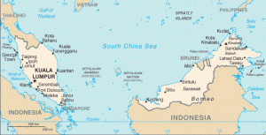
Malaysia is a spectacular Southeast Asian nation split across two distinct landmasses: Peninsular Malaysia, which shares its southern tip with Singapore and its northern border with Thailand, and East Malaysia, comprising the Bornean states of Sabah and Sarawak. For drivers, this means two very different experiences — the modern, toll-heavy highway network of the Peninsula with its bustling Klang Valley conurbation, and the wilder, more rural roads of Borneo where rainforest, wildlife, and often-challenging terrain define every journey.
Malaysia drives on the left, a legacy of British colonial rule, and uses right-hand drive vehicles. The road network on the Peninsula is extensive and largely well-maintained, anchored by the legendary North-South Expressway (PLUS Highway) stretching almost 1,000 kilometres from the Thai border to Singapore. Tolls are a daily reality on the expressway network, paid via the ubiquitous Touch ‘n Go contactless card system or its RFID equivalent — while federal and state roads remain completely free of charge. The blood alcohol limit is 0.08% BAC (80 mg/100 ml) — the same standard as the United Kingdom and Singapore. The currency is the Malaysian Ringgit (RM / MYR). Emergency services are reached on 999 for Police, Fire, and Ambulance; the international number 112 also connects from mobile phones. Use the route planner on our homepage to plan your Malaysian road trip.
Road Network Overview
Malaysia’s road network totals approximately 230,000 kilometres, ranging from modern six-lane expressways to narrow logging tracks in Borneo. The system is administered by the Road Transport Department (JPJ — Jabatan Pengangkutan Jalan) and maintained by a combination of the federal government, state governments, and private highway concessionaires. Expressways are designated with an E prefix and form the backbone of long-distance travel on the Peninsula.
Key expressways on Peninsular Malaysia:
- E1 — North-South Expressway (PLUS Highway): The most important road in Malaysia, stretching approximately 966 kilometres from Bukit Kayu Hitam at the Thai border in Kedah to Johor Bahru at the Singapore border. Operated by PLUS Expressways, it passes through Alor Setar, Ipoh, Kuala Lumpur, Seremban, and Johor Bahru — the lifeblood of peninsular commerce and travel.
- E2 — North-South Expressway Central Link (Elite Highway): An alternative route through the western central corridor, linking Kuala Lumpur (Subang) south to Seremban and connecting to Johor.
- E5 — KL–Karak Expressway: The key artery heading east from KL across the Titiwangsa mountain range to Pahang, serving Genting Highlands and onward to the East Coast Expressway.
- E8 — East Coast Expressway (LPT): In two phases, this expressway runs from Karak through Kuantan, Kemaman, and Kerteh all the way to Kuala Terengganu, dramatically cutting driving times to the East Coast.
- Penang Bridges (E20 / E28): The First Penang Bridge (13.5 km) and the Second Penang Bridge / Sultan Abdul Halim Mu’adzam Shah Bridge (24 km — one of the longest sea crossings in Southeast Asia) connect Penang Island to the mainland.
- Klang Valley Network: A dense web of expressways encircles Greater Kuala Lumpur — including the Federal Highway (FT2), NKVE, LDP, SPRINT, NPE, KESAS, SKVE, MEX, DUKE, SUKE, and EKVE. Navigation via Waze or Google Maps is practically essential in this network.
Federal roads (Jalan Persekutuan) form the secondary intercity network, connecting towns not served by expressways. Speed limits are generally 90 km/h outside built-up areas. Route 1 (Jalan 1) roughly parallels the North-South Expressway along the entire peninsula and offers a toll-free alternative, though it is significantly slower and passes through numerous towns. Federal roads are not tolled, making them a practical choice for budget travellers or those who prefer a slower, more scenic journey through Malaysian kampung (village) life. State roads connect villages and rural areas; quality varies considerably. In Sabah and Sarawak, roads marked as logging tracks or jungle tracks may require a high-clearance 4×4 vehicle, and some sections can be impassable during heavy monsoon rainfall.
The SMART Tunnel (Stormwater Management and Road Tunnel) in Kuala Lumpur is a unique dual-purpose infrastructure marvel beneath the city. Its 9.7-kilometre road section carries two lanes of traffic through the heart of KL, relieving central congestion. During severe rainfall events, the lower section activates to redirect floodwater away from the city centre — temporarily closing the road portion. Motorists may encounter sudden tunnel closures during heavy downpours. Always check the SMART Tunnel status hotline (1800-88-7344) before entering when rain is heavy, and monitor the PLUS Expressways or Waze apps for real-time diversion information.
Speed Limits
Speed limits in Malaysia are enforced by a combination of fixed speed cameras (AES — Automated Enforcement System), point-to-point average speed cameras on selected expressway sections, and mobile speed checks by PDRM Traffic Police. AES summonses are issued by post and can be paid via the MySikap portal or the MyBayar Saman app. Outstanding fines must be cleared before vehicle road tax renewal.
| Road Type | Speed Limit | Notes |
|---|---|---|
| Expressway (Lebuh Raya) | 110 km/h | Standard maximum; reduce in rain or poor visibility |
| Federal / state roads (outside built-up areas) | 90 km/h | Single and dual carriageway intercity roads |
| Built-up areas / urban roads | 60 km/h | Default in towns; some residential streets posted 50 km/h |
| Residential streets (signed) | 50 km/h | Or as posted on signage |
| School zones (during school hours) | 30 km/h | Flashing warning signs during school hours |
Malaysia uses a demerit points (Merit System) — new drivers start at 0 and accumulate demerit points for traffic offences; reaching 20 demerit points results in licence suspension. Serious offences including dangerous driving, drink driving, and causing death by dangerous driving carry criminal penalties under the Road Transport Act 1987 and its significant 2020 amendments, which dramatically increased maximum fines and imprisonment terms across a wide range of offences. The 2020 amendments also criminalised persistent tailgating and obstructing the passage of emergency vehicles — both now punishable offences in Malaysian law.
Tolls & Touch ‘n Go
Malaysia operates a pay-per-use toll system on expressways — there is no national vignette or annual road sticker for visitors. Federal and state roads are toll-free. Obtaining a Touch ‘n Go (TnG) card or downloading the TnG eWallet app before hitting Malaysian expressways is strongly recommended. TnG cards are sold at all PLUS toll plazas, 7-Eleven, petrol stations, and convenience stores.
RFID tolling has been progressively rolled out since 2020. Vehicles with an RFID sticker on the windscreen pass through dedicated RFID lanes at reduced speed without stopping — charges are automatically deducted from the linked TnG eWallet. Foreign-registered vehicles without RFID can use cash lanes or SmartTAG lanes. SmartTAG is the older dashboard transponder system, still widely accepted, though RFID and the TnG eWallet are gradually superseding it. Ask your car rental company whether RFID or SmartTAG is already fitted.
| Route / Plaza | Approx. Toll (Class 1 car, 2026) |
|---|---|
| North-South Expressway: Bukit Kayu Hitam → Johor Bahru (full length) | RM 85–95 one way |
| North-South Expressway: KL → Ipoh (~200 km) | RM 22–26 |
| First Penang Bridge (to island) | RM 7.00 (free returning) |
| Second Penang Bridge / Sultan Abdul Halim Shah Bridge (to island) | RM 8.50 (free returning) |
| KL–Karak Expressway (full) | RM 7–10 |
| SMART Tunnel, Kuala Lumpur | RM 2.00 |
| East Coast Expressway (Karak → Kuala Terengganu) | RM 30–38 |
| Klang Valley expressways (per entry/exit) | RM 1.00–6.00 typically |
Toll rates are reviewed periodically by the government as part of concession agreements. Check the PLUS Expressways website (plus.com.my) or the TnG eWallet app for current rates. All major toll plazas maintain cash lanes; however, during peak hours on the North-South Expressway, cash queues can be very long — TnG, RFID, or SmartTAG lanes move considerably faster.
Road Rules & Driving Law
Malaysia drives on the left; vehicles have the steering wheel on the right. Visitors from left-hand traffic countries (UK, Australia, New Zealand, Singapore, Japan) will feel immediately at home. Visitors from right-hand traffic countries should take extra care at junctions and roundabouts — remember to look right first when pulling out and to stay in the left-hand lane as default. At roundabouts, traffic inside has right of way; vehicles entering must give way to circulating traffic.
Drink driving: The legal blood alcohol limit is 0.08% (80 mg per 100 ml of blood) — the same as the UK and Singapore, and higher than the EU standard of 0.05%. However, drink driving is a serious criminal offence in Malaysia and carries heavy penalties: first-time offenders face fines of up to RM 1,000 and/or six months’ imprisonment; repeat offenders face up to two years’ imprisonment. PDRM conducts roadblocks (sekatan jalan raya) regularly, especially on Friday and Saturday nights. The safest approach is zero alcohol if driving.
Mobile phones: Using a handheld mobile phone while driving is prohibited — fines start at RM 1,000 for a first offence under the 2020 Road Transport Act amendments. Hands-free use is permitted. Seatbelts are mandatory for all occupants in all seats; children under 1 metre must be in an appropriate child seat. PDRM enforcement of seatbelt compliance has increased substantially, with on-the-spot fines of RM 300.
Licences for foreign visitors: Visitors may drive using their valid foreign driving licence for up to three months. An International Driving Permit (IDP) is strongly recommended, particularly for non-English licences. Rental companies may require an IDP. For stays exceeding three months, conversion to a Malaysian licence through JPJ is required.
Road Transport Department (JPJ): JPJ regulates vehicle registration, licensing, and roadworthiness. All Malaysia-registered vehicles must display valid road tax (cukai jalan) — a windscreen sticker renewed annually. Vehicles older than five years must pass a roadworthiness inspection at PUSPAKOM centres before road tax renewal.
Motorcycles: Malaysia has an enormous motorcycle culture — motorcycles account for more than half of all registered vehicles. As a car driver, be vigilant for motorcycles filtering between lanes, particularly in slow or stationary traffic on expressways and federal roads.
PDRM roadblocks: Police roadblocks (sekatan jalan raya) are very common on Malaysian roads at all times of day and night — on expressways, federal roads, and urban streets alike. They check road tax, driving licences, insurance, seatbelts, alcohol level (breathalyser), and sometimes vehicle roadworthiness. Be courteous, pull over promptly, and have your licence, passport (for foreign visitors), and vehicle documents ready. Officers usually speak sufficient English for basic interaction. Fines may be paid on the spot and a receipt must be issued, or the fine can be paid later via the MySikap portal or the MyBayar Saman app within the stated deadline. Do not offer money unsolicited — that constitutes bribery and is a serious offence in Malaysia.
Parking: In major cities, multi-storey car parks, surface lots, and metered on-street bays are widely available. Coupon parking is widely used in towns — purchase coupon booklets from petrol stations or convenience stores and scratch off the date and time blocks relevant to your arrival. Electronic parking metres (pay-and-display or sensor-based) are increasingly common in newer urban developments and shopping district upgrades. Shopping mall parking is generally generous and inexpensive — usually free for the first one to two hours with validation. Clamping and towing of illegally parked vehicles is actively enforced in Kuala Lumpur, Penang, and other major cities; release fees are significant. Always park in designated bays and check for yellow lines or no-parking signs before leaving the vehicle.
Fuel & Petrol Stations
Malaysia produces its own petroleum via Petronas (Petroliam Nasional Bhd) and fuel is widely available throughout the Peninsula. The main grades are:
- RON 95: Standard unleaded petrol, historically heavily subsidised for Malaysian citizens and permanent residents. As of 2024–2026, the government has been progressively rationalising RON 95 subsidies — foreign-registered vehicles are generally required to purchase RON 95 at the unsubsidised price, or use RON 97 instead. Rules are evolving; check current policy at the time of travel.
- RON 97: Premium unleaded, sold at the unsubsidised market price. This is the standard fuel for foreign visitors when RON 95 subsidy restrictions apply. It is widely available at all major petrol station brands.
- Diesel: Available at most petrol stations; similar subsidy restrictions apply for foreign vehicles.
- EV Charging: Electric vehicle charging is expanding rapidly, with Petronas, Shell, ChargEV, and JomCharge networks growing. EV chargers are available at major shopping centres, highway rest areas, and petrol stations in urban areas.
The dominant petrol station brands are Petronas, Shell, Petron, BHP, and Caltex. PLUS highway rest areas (R&R — Rehat & Rawat) include Petronas petrol stations, food courts, toilets, and prayer rooms (surau), spaced at roughly 40–60 km intervals. Fuel availability is spottier in rural East Malaysia — plan ahead on longer Borneo routes and fill up whenever opportunity arises.
Border Crossings: Singapore & Thailand
Two land crossing points connect Peninsular Malaysia with Singapore. Both countries drive on the left — no side-switch is required at the border.
- Johor Bahru–Woodlands Causeway (Bangunan Sultan Iskandar): The busier crossing, connecting JB city directly to Woodlands, Singapore. Queues can be extremely long during peak periods — Friday evenings, Sunday evenings, Malaysian and Singapore school holidays, and public holidays. A toll applies to private cars departing Malaysia. Malaysian-registered vehicles entering Singapore require a Singapore-issued VEP (Vehicle Entry Permit) — apply online at vep.jpj.gov.my before travel. Verify that your vehicle insurance covers Singapore use.
- Tuas Second Link (Sultan Abu Bakar Complex): Located in western JB, connecting to Tuas, Singapore. Generally has shorter queues than the Causeway; preferred for those heading to western Singapore or the Jurong industrial zone. A toll is payable on both sides.
For the Malaysia–Thailand border, the principal crossings are Bukit Kayu Hitam / Sadao (west coast / North-South Expressway, connecting to Hat Yai and Thailand’s southern highway network) and Rantau Panjang / Sungai Golok (east coast, Kelantan). A further minor crossing at Padang Besar in Perlis is used mainly by locals and the rail link. Note that the deep south provinces of Thailand (Pattani, Yala, Narathiwat) have experienced a long-running low-level insurgency — most foreign governments advise heightened caution or against non-essential travel to these specific provinces. Check your government’s current travel advisory before planning any driving itinerary through this area. Crucially, crossing into Thailand means switching to right-hand traffic — Thailand drives on the left like Malaysia, so no side-switch is required. However, be alert to differences in road signage and the transition from the Malaysian to Thai road environment immediately after the checkpoint.
Driving in Sabah & Sarawak (East Malaysia)
East Malaysia — the states of Sabah and Sarawak on the island of Borneo — offers one of the most dramatic and rewarding driving experiences in Southeast Asia, but it requires careful preparation and very different expectations from Peninsular Malaysia. Road density is far lower; the highway network is limited; and most roads are two-lane federal or state roads.
The Pan Borneo Highway is a major ongoing infrastructure project aiming to upgrade and complete a continuous highway corridor from Teluk Melano in western Sarawak to Tawau in eastern Sabah — over 2,300 kilometres. Significant sections are already upgraded, but construction is ongoing into the late 2020s; expect narrow roads, potholes, and construction diversions on incomplete sections.
In Sabah, key routes run from Kota Kinabalu north to Kudat, east to Sandakan (approximately 5–6 hours), and south to Tawau through Lahad Datu and Semporna. The Sandakan road crosses undulating oil-palm terrain. In Sarawak, the coastal corridor road from Kuching north to Bintulu and Miri is feasible, though journey times are long.
Wildlife hazards in Borneo: East Malaysia hosts extraordinary biodiversity. Proboscis monkeys, orangutans, pygmy elephants (Kinabatangan corridor, Sabah), sun bears, and bearded pigs can all appear on roads — especially at dawn and dusk. The Kinabatangan floodplain roads demand very slow, careful driving. Wildlife crossing signs in national park corridors must be treated seriously.
Fuel in East Malaysia: Fuel availability on Borneo is considerably spottier than on the Peninsula, particularly on long cross-state routes. Fill up whenever you encounter a petrol station, especially before heading into the interior. On the Pan Borneo Highway sections currently under construction, detours and reduced road quality are common — allow significantly more journey time than mapping apps suggest, and carry a paper map as a backup since mobile data coverage can be unreliable in remote areas.
Important immigration note: Peninsular Malaysia and East Malaysia maintain their own immigration controls under Malaysia’s unique federal structure. Crossing from the Peninsula to Sabah or Sarawak (by air or sea — no road link exists between the Peninsula and Borneo) requires full immigration processing at the port of entry. Travel between Sabah and Sarawak also involves an immigration check, even for Malaysian citizens. Foreign visitors must ensure their passport remains valid and that their visa (where required) permits multiple entries if they plan to travel between both parts of East Malaysia.
Road Hazards: Monsoons, Wildlife & More
Malaysia experiences two monsoon seasons, both of which significantly affect driving conditions:
- Northeast Monsoon (November–March): Brings heavy rainfall to the East Coast of Peninsular Malaysia (Kelantan, Terengganu, Pahang east coast) and parts of Sabah and Sarawak. Annual floods can inundate federal roads and even sections of the East Coast Expressway. Check the InfoBanjir flood warning system (publicinfobanjir.water.gov.my) before travelling east during November to January.
- Southwest Monsoon (May–September): Affects western and inland areas; generally less severe on the Peninsula but brings heavy rain and reduced visibility. Landslides can occur on mountain roads (Cameron Highlands, Genting Highlands, Fraser’s Hill) during intense rainfall.
Heavy tropical rainfall can reduce visibility to near zero within minutes. When heavy rain begins on a Malaysian expressway, slow down significantly, turn on headlights, and increase following distance. Pull off at the next R&R rest area if you cannot see adequately — do not maintain 110 km/h in near-zero visibility.
Flash flooding in Kuala Lumpur is a recurring hazard, particularly during the inter-monsoon periods (April–May, October–November). Avoid driving through floodwater of unknown depth — 30 cm of fast-moving water can stall a car. Monitor the SMART Tunnel Hotline (1800-88-7344) and Waze/PLUS Expressways app during heavy rain.
On Peninsular Malaysia, monkeys, monitor lizards, wild boar, tapir, and in the Gerik–Jeli corridor, even elephants can appear on roads. The Gerik to Jeli road through Royal Belum State Park has elephant crossing warning signs — take these seriously and drive slowly at night. Malaysia’s sun glare at sunrise and sunset on east–west oriented roads can also be severe; keep sunglasses accessible.
The North-South Expressway’s 966 km length is deceptive — PLUS R&R rest areas are spaced at roughly 40–60 km intervals specifically to encourage breaks. During major festive periods — Hari Raya Aidilfitri (end of Ramadan) and Chinese New Year — the North-South Expressway carries millions of vehicles as Malaysians balik kampung (return to their hometowns). These festive exoduses are some of the heaviest traffic events in Southeast Asia. If travelling during these periods, plan to drive at off-peak hours (before 06:00 or after 22:00) and check PLUS Expressways for contraflow and lane management arrangements. Fatigue is a leading cause of expressway fatalities in Malaysia — the PLUS “Ops Selamat” safety operations during festive seasons increase enforcement and promote rest stops.
Scenic Drives & Road Trip Routes
Cameron Highlands (Pahang): The winding mountain road from Tapah (off the North-South Expressway) ascending to the cool-climate tea plateau of Cameron Highlands at around 1,500 metres is one of Malaysia’s most iconic drives. The road is narrow, steep, and full of hairpin bends, with breathtaking views of tea plantations, vegetable farms, and jungle valleys. Allow 1.5–2 hours for the 47-kilometre ascent from Tapah; stay left on bends; be aware of tour buses and motorcycles. Best driven outside monsoon season in dry conditions.
The East Coast Road Trip: Taking the East Coast Expressway from Karak east to Kuantan, then the coastal federal road north through Kemaman, Kerteh, Kuala Terengganu, and up to Kota Bharu in Kelantan is one of Malaysia’s great road trips. The East Coast beaches — Cherating, Kuala Dungun, Marang — define a gentler, more rural Malaysia. Best driven outside the northeast monsoon season (avoid November–January).
Penang Island: Crossing via either Penang Bridge offers a dramatic approach to Penang Island. Georgetown’s UNESCO heritage streets, the coastal perimeter road (Gurney Drive, Batu Feringghi, Teluk Bahang), and the mountain road to Penang Hill make for superb exploration. Parking in Georgetown’s heritage core can be challenging — park at the fringe and walk or use a rideshare for the old city.
Genting Highlands: The toll road ascending to Genting Highlands switchbacks dramatically from Gohtong Jaya (reached via the Karak Expressway) up to the summit resort complex at nearly 1,800 metres. The road is well-engineered and maintained. Morning cloud on the summit frequently dissipates by mid-morning.
Gerik to Jeli — Royal Belum: The road through Royal Belum State Park from Gerik north to Jeli passes through one of the oldest rainforests in the world. The route crosses Temenggor Lake on a causeway and traverses the most wildlife-rich corridor remaining on the Malay Peninsula. Drive with extreme caution at night; elephant and tapir crossings are genuine risks.
Sabah Coastal Road — Kota Kinabalu to the Tip of Borneo: Driving north from Kota Kinabalu along Sabah’s west coast toward Tuaran, Kota Belud, Kudat, and the Tip of Borneo at Simpang Mengayau passes paddy fields, sea views, and the spectacular backdrop of Mount Kinabalu (4,095 m — Southeast Asia’s highest peak). The approach to the Tip of Borneo — where the South China Sea meets the Sulu Sea — is one of the most dramatic road-trip destinations in the region.
Sarawak Coastal Highway — Kuching to Miri: The coastal drive in Sarawak from Kuching northeast to Sibu (reached via a ferry crossing over the Rajang River — Sarawak’s vast, commercially important waterway), then on to Bintulu and Miri covers roughly 800 kilometres. Pan Borneo Highway upgrades have improved much of this corridor, though construction sections remain. Miri serves as the gateway to Mulu National Park (UNESCO World Heritage Site) — home to the world’s largest cave chamber (Sarawak Chamber), the extraordinary Deer Cave bat colony, and some of the most dramatic karst limestone landscapes on earth. The Mulu National Park itself is accessed by small aircraft or river boat from Miri, but the coastal highway drive to Miri is a rewarding journey through Sarawak’s longhouse communities and coastal wetlands.
Roadside assistance in Malaysia: On the PLUS North-South Expressway, help is available via the PLUS Emergency Response Team — call 1800-88-0000 (toll-free, 24 hours) from anywhere on the PLUS network. Emergency SOS phones are located at regular intervals along the expressway. AAM (Automobile Association of Malaysia) provides national roadside assistance at 03-7954 4999. Most rental car companies also provide their own 24-hour breakdown lines — note the number before departure. If your vehicle breaks down on a live expressway lane, turn on hazard lights, move to the hard shoulder immediately, exit the vehicle via the passenger-side door (away from traffic), and move behind the safety barrier before calling for help.
FAQ: Driving in Malaysia
Do I need a vignette or road disc to drive in Malaysia?
No vignette is required in Malaysia. The country uses a pay-per-use toll system on expressways, paid via Touch ‘n Go card, RFID, SmartTAG, or cash at toll plazas. Federal and state roads are free of charge. There is no annual road sticker required of visitors — only Malaysia-registered vehicles pay annual road tax (cukai jalan).
Can I use my foreign driving licence in Malaysia?
Yes. A valid foreign driving licence is accepted for up to three months for most foreign nationals. An International Driving Permit (IDP) is strongly recommended, particularly for non-English licences. Rental car companies may require an IDP. ASEAN licence holders generally have no practical issues. For stays longer than three months, a Malaysian licence conversion through JPJ is required.
Which side of the road does Malaysia drive on?
Malaysia drives on the left, with right-hand drive vehicles — the same as the UK, Australia, Singapore, New Zealand, Japan, and India. Visitors from right-hand traffic countries (continental Europe, Americas, most of Asia) must consciously adjust, particularly at junctions, roundabouts, and when joining roads. Always default to the left-hand lane.
Is it safe to drive between Malaysia and Singapore?
Yes. The Johor Bahru–Singapore crossing via the Causeway or Second Link is straightforward, though queues can be very long during peak periods. Ensure your vehicle insurance covers Singapore. Malaysian-registered vehicles require a Singapore-issued VEP (Vehicle Entry Permit — apply at vep.jpj.gov.my before travel). Both countries drive on the left, so no side-switch is required at the border. The Second Link (Tuas) is usually less congested than the Causeway.
What fuel should foreign vehicles use in Malaysia?
Foreign-registered vehicles are generally not entitled to the subsidised RON 95 petrol that Malaysian residents receive. Use RON 97 or be prepared to pay the non-subsidised price for RON 95. Subsidy rationalisation policy is actively evolving — check the current rules at the time of travel. RON 97 is widely available at all major petrol station brands throughout Peninsular Malaysia.
What should I do if stopped at a Malaysian police roadblock?
PDRM roadblocks (sekatan jalan raya) are very common in Malaysia. Stop calmly, have your licence, passport (for foreign visitors), vehicle registration documents, and insurance certificate accessible. Officers usually speak sufficient English and will check documents before waving you through if everything is in order. Do not offer money — that constitutes bribery. If issued a summons (compound), ask for a printed receipt and settle via the MySikap or MyBayar Saman system.
Sources and Update Note
This Malaysia driving guide draws on information from the Jabatan Pengangkutan Jalan (JPJ) (jpj.gov.my) for licensing and vehicle regulations, PLUS Expressways Berhad (plus.com.my) for expressway tolls and rest areas, Touch ‘n Go Sdn Bhd (touchngo.com.my) for toll payment systems, the Royal Malaysia Police (PDRM) (rmp.gov.my) for traffic law and enforcement, the Malaysia Meteorological Department (MetMalaysia) (met.gov.my) for monsoon and weather data, the Department of Irrigation and Drainage Malaysia (publicinfobanjir.water.gov.my) for flood warning data, and the Road Transport Act 1987 (as amended 2020) for legal requirements. Cross-border information draws on the Immigration and Checkpoints Authority of Singapore (ica.gov.sg) and JPJ Malaysia VEP (vep.jpj.gov.my).
Toll rates are reviewed periodically under concession agreements; fuel subsidy policy continues to evolve — verify current rates and subsidy rules before travel. VEP requirements for the Singapore border are subject to change — always check vep.jpj.gov.my before crossing. This guide reflects information current as of February 2026.