
 |
 |
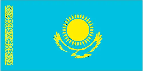 |
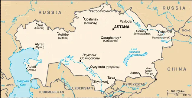
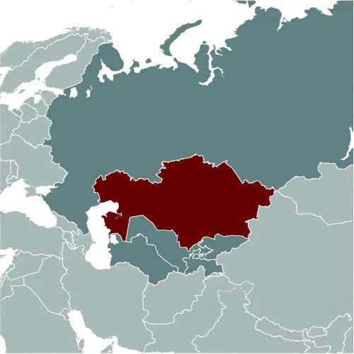
| Borderline map of Kazakhstan | Location map of Kazakhstan | Flag of Kazakhstan |
Google Maps and Detailed Facts of Kazakhstan (KZ). This page lets you explore Kazakhstan and its border countries (Country Location: Central Asia, northwest of China; a small portion west of the Ural (Zhayyq) River in easternmost Europe) through detailed Satellite imagery – fast and easy as never before Google Maps.
Find comprehensive information about this country’s diversity below: Google Maps, geography, economy, science, people, culture, environment, government, and history – All in One Wiki page.
There is also a Street View and free Driving Directions at your service. Your Google Satellite Map Sightseeing in Kazakhstan, in Asia, starts here at Driving Directions and Maps.com.
Kazakhstan Google Maps & Satellite Maps
The map below shows Kazakhstan with its cities, towns, highways, main roads, streets, and Street Views. To find a location, use the form below, type any city or place, view a simple map, and click the “show map” button.
The Google Maps above shows Kazakhstan with its location: Asia (geographic coordinates: 48 00 N, 68 00 E) and the international borders of Kazakhstan; total: 13,364 km. Border countries (total: 5): China 1,765 km, Kyrgyzstan 1,212 km, Russia 7,644 km, Turkmenistan 413 km, Uzbekistan 2,330 km, furthermore, it’s inland counties boundaries.
Hint: Look at the Street view in Kazakhstan or Asia. All you have to do is drag and pull the little yellow man (named: Pegman) on the Google Maps above the desired location. After that, whenever it is available (more than 50 countries globally), blue stripes will appear to show the photos and details from Google’s regularly updated data image base. In case if you have signed in to your Google account currently, you may have a look at the satellite map of this country/area as well.
The map of Kazakhstan, Asia, is for informational use only. No representation is made or warrantied given any map or its content by Driving Directions and Maps site. The user assumes all risks of using this Kazakhstan Google Maps and facts/wiki.
About Kazakhstan in detail
Where is Kazakhstan?
Kazakhstan, in case, if you are looking on the map under the Coordinates 51 10 N 71 25 E otherwise in Asia, in Central Asia, northwest of China; a small portion west of the Ural (Zhayyq) River in easternmost Europe.
What is the capital city of Kazakhstan?
The capital city of Kazakhstan is Astana.
What is the time in Astana?
It is 11 hours ahead of Washington, D.C. during Standard Time; the timezone of Astana is UTC+6.
What is the Internet code for Kazakhstan?
The Top Level Domain (TLD) for Kazakhstan is: .kz
What is the size of Kazakhstan?
The territory of Kazakhstan is total: 2,724,900 sq km; land: 2,699,700 sq km, water: 25,200 sq km.
If we want to describe the size of Kazakhstan’s territory is slightly less than four times the Texas size.
If we would like to walk around and discover Kazakhstan, we can cover a total distance: 13,364 km.
What is the water coverage of Kazakhstan?
We have already mentioned what percentage of Kazakhstan is covered by water (see below), and this includes 0 km (landlocked country); note – Kazakhstan borders the Aral Sea, now split into two bodies of water (1,070 km), and the Caspian Sea (1,894 km) coastline.
What is the climate like in Kazakhstan?
The climate of Kazakhstan is continental, with cold winters and hot summers, arid and semiarid.
Geographical data of Kazakhstan
Kazakhstan’s elevation; mean elevation: 387 m, elevation extremes; lowest point: Vpadina Kaundy -132 m, highest point: Khan Tangiri Shyngy 6,995 m.
Kazakhstan’s specific geographical details include a vast flat steppe extending from the Volga in the west to the Altai Mountains in the east and from the plains of western Siberia in the north to oases and deserts of Central Asia in the south.
Suppose we would like to describe the countries location from a different perspective. In that case, it is safe to say, and easy to read from a map, Kazakhstan is the world’s largest landlocked country; Russia leases approximately 6,000 sq km of territory enclosing the Baykonur Cosmodrome; in January 2004, Kazakhstan and Russia extended the lease to 2050.
Resources and land use of Kazakhstan
The country’s main mined products are major deposits of petroleum, natural gas, coal, iron ore, manganese, chrome ore, nickel, cobalt, copper, molybdenum, lead, zinc, bauxite, gold, uranium. The population partly uses the earlier highlighted land territory and partly left in its natural state: agricultural land: 77.4%; arable land 8.9%; permanent crops 0%; permanent pasture 68.5%; forest: 1.2%; other: 21.4% (2011 estimate).
Population data of Kazakhstan
The number of inhabitants of Kazakhstan is 18,360,353 (July 2016 estimate).
If we examine the proportion of the population distribution, it is safe to say that most of the country displays a low population density, particularly the interior; population clusters appear in urban agglomerations in the far northern and southern portions of the country.
If we look at the proportion of the urbanized and barely populated areas, these are the figures: urban population: 53.2% of the total population (2015).
Most of the population in Kazakhstan is concentrated in Almaty 1.523 million; ASTANA (capital) 759,000 (2015).
Ethnicity in Kazakhstan
According to ethnicity details, the ethnic groups are Kazakh (Qazaq) 63.1%, Russian 23.7%, Uzbek 2.9%, Ukrainian 2.1%, Uighur 1.4%, Tatar 1.3%, German 1.1%, other 4.4% (2009 estimate).
Spoken languages in Kazakhstan
The spoken languages in Kazakhstan are the following: Kazakh (official language, Qazaq) 74% (understand spoken language), Russian (official language, used in everyday business, designated the “language of interethnic communication”) 94.4% (understand spoken language) (2009 estimate).
What are the most important religions in Kazakhstan?
According to this general census, researchers examine the churches: Muslim 70.2%, Christian 26.2% (mainly Russian Orthodox), other 0.2%, atheist 2.8%, unspecified 0.5% (2009 estimate).
Further population data of Kazakhstan
The proportion of gender and age tells a lot about the society as follows 0-14 years: 25.68% (male 2,336,444 / female 2,378,769) 15-24 years: 14.66% (male 1,371,133 / female 1,319,938) 25-54 years: 42.5% (male 3,808,164 / female 3,994,781) 55-64 years: 9.77% (male 784,035 / female 1,008,935) 65 years and over: 7.4% (male 470,485 / female 887,669) (2016 estimate). It also a significant factor in a society the population growth rate, which in the case of Kazakhstan is 1.09% (2016 estimate).
The population growth rate is based on two elements, the birth, and the death rate. In Kazakhstan the birth rate is 18.7 births / 1,000 population (2016 estimate), the death rate 8.2 deaths / 1,000 population (2016 estimate).
In this day and age in developed societies, the first child borns later compared to the previous centuries and decades, so childbearing is extended. In Kazakhstan, the average age of mothers at the first childbirth is N/A.
Although the children’s birth is postponed in the best-case scenario, the parents can still see their kids grow as life expectancy also extended. In the case of Kazakhstan, these figures are. With the introduction of modern medicine, vaccinations, and the proper hygienic conditions, the infant mortality rate is in a steep decline. The infant mortality statistics in Kazakhstan are the following: N/A. Relevant data is the budget of healthcare, which is in the case of this country is 4.4% of GDP (2014).
Economic data of Kazakhstan
Suppose we would like to describe a country. We also have to mention its economy; Kazakhstan, geographically the largest of the former Soviet republics, excluding Russia, possesses substantial fossil fuel reserves and other minerals and metals, such as uranium, copper-zinc. It also has a large agricultural sector featuring livestock. Kazakhstan’s vast hydrocarbon and mineral reserves form the backbone of its economy. Kazakhstan is landlocked and depends on Russia to export its oil to Europe. In 2010, Kazakhstan joined Russia and Belarus to establish a Customs Union. The economic downturn of its EEU partner, Russia, and the decline in global commodity prices have contributed to an economic slowdown in Kazakhstan, which is experiencing its slowest economic growth since the financial crises of 2008-09.
GDP is a prominent figure, as all the relevant calculations and statistics are based on it. GDP in Kazakhstan is $128.1 billion (2015 estimate).
Another important indicator is the rate of GDP growth, which in Kazakhstan is -0.8% (2016 estimate), 1.2% (2015 estimate) 4.3% (2014 estimate).
These statistics affect the world economy; remember, in 2015, the Chinese real GDP growth rate was worse than expected; The world markets fall, and the Chinese stock exchange was temporally suspended.
A further major factor of a country’s economy, the GDP per capita. In Kazakhstan this is $25,700 (2016 estimate) $26,300 (2015 estimate) $26,300 (2014 estimate).
In the economy, the Trinity is in common places, such as agriculture, industry, and services.
What are the agricultural products Kazakhstan produces?
Kazakhstan’s main agricultural products are grain (mostly spring wheat and barley), potatoes, vegetables, melons, livestock.
The essential segments are oil, coal, iron ore, manganese, chromite, lead, zinc, copper, titanium, bauxite, gold, silver, phosphates, and sulfur uranium steel; tractors and other agricultural machinery, electric motors, construction materials. The crucial and regularly mentioned GDP is based on oil, coal, iron ore, manganese, chromite, lead, zinc, copper, titanium, bauxite, gold, silver, phosphates, sulfur, uranium, iron, and steel; tractors and other agricultural machinery, electric motors, construction materials.
Drinking water source in Kazakhstan
It is essential to mention that – thanks to the development of the infrastructure -, the rate of potable water improved: urban: 99.4% of the population, rural: 85.6% of the population, total: 92.9% of the population. Unimproved: urban: 0.6% of the population, rural: 14.4% of the population, total: 7.1% of the population (2015 estimate).
The average number of childbirth in Kazakhstan
In Kazakhstan, the average delivery number is 2.28 children born / woman (2016 estimate).
Population, median age, migration, and citizenship in Kazakhstan
The population’s average age is 30.3 years; male: 29 years, female: 31.6 years (2016 estimate). The age of adulthood varies in every country of the world in Kazakhstan; it is 18 years of age, universal.
When we are experiencing an unprecedented scale of migration and globalization, it is an important factor in the number of new immigrants. In Kazakhstan is 0.4 migrant(s) / 1,000 population (2016 estimate). It is important to know how to apply for citizenship: citizenship by birth: no. Citizenship by descent only: at least one parent must be a citizen of Kazakhstan. Dual citizenship recognized: no—residency requirement for naturalization: 5 years.
Is Kazakhstan a safe destination? Healthcare services and infectious diseases in Kazakhstan
Many of the travelers are looking into the healthcare services and infectious diseases of their destinations. In Kazakhstan, the hospital beds’ density is 7.2 beds / 1,000 population (2012).
According to the WHO rating regarding contagious diseases in Kazakhstan: N/A.
However, HIV is not curable but maintainable. Let’s do not forget when the disease surfaced; it was a world threatening condition. Unfortunately, in some countries, it is still very high the number of infected patients and fatalities due to the disease.
In Kazakhstan, the number of HIV/AIDS deaths: N/A.
Regarding tourism obesity, not an important issue, but we have to mention health statistics, as it is the plague of the 20th and the 21st century. The rate of obese adults in Kazakhstan is 23.5% (2014).
What are the natural hazards in Kazakhstan? Is there any?
The most known natural risk in Kazakhstan is earthquakes in the south; mudslides around Almaty.
More interesting facts about Kazakhstan
A few words about the past, as every country and society is connected to its history; Ethnic Kazakhs, a mix of Turkic and Mongol nomadic tribes who migrated to the region by the 13th century, were rarely united as a single nation. Russia conquered the area in the 18th century, and Kazakhstan became the Soviet Republic in 1936. Soviet policies reduced the number of ethnic Kazakhs in the 1930s and enabled non-ethnic Kazakhs to outnumber natives. During the 1950s and 1960s agricultural “Virgin Lands” program, Soviet citizens were encouraged to cultivate Kazakhstan’s northern pastures. This influx of immigrants (mostly Russians and some other deported nationalities) further skewed the ethnic mixture.
Non-Muslim ethnic minorities departed Kazakhstan in large numbers from the mid-1990s through the mid-2000s, and a national program has repatriated about a million ethnic Kazakhs back to Kazakhstan. These trends have allowed Kazakhs to become the titular majority again. This dramatic demographic shift has also undermined the previous religious diversity and made the country more than 70% Muslim. Kazakhstan’s economy is larger than those of all the other Central Asian states due to its vast natural resources. Current issues include: developing a cohesive national identity, expanding the country’s vast energy resources and exporting them to world markets, diversifying the economy, enhancing Kazakhstan’s economic competitiveness, and strengthening relations with neighboring states and foreign powers.
In every nation’s memory, some cornerstones placed the country on the timeline of history. The date of declaration of independence of Kazakhstan: 16 December 1991 (from the Soviet Union).
The flag and other symbols of Kazakhstan
The colors, symbols, and animals on the flag usually have a historical background or an important milestone or memory of the nation.
This case is not an exception either; a gold sun with 32 rays above a soaring golden steppe eagle, both centered on a sky blue background; the hoist side displays a national ornamental pattern “koshkar-muiz” (the horns of the ram) in gold; the blue color is of religious significance to the Turkic peoples of the country, and so symbolizes cultural and ethnic unity; it also represents the endless sky as well as water; the sun, a source of life and energy, exemplifies wealth and plenitude; the sun’s rays are shaped like grain, which is the basis of abundance and prosperity; the eagle has appeared on the flags of Kazakh tribes for centuries and represents freedom, power, and the flight to the future; blue and yellow are the national colors.
Apart from the flag, the symbol of national unity is the national anthem. The anthem’s primary purpose is to share the nation’s core values, endeavors, and patriotic feelings.
National symbols of Kazakhstan: golden eagle; national colors: blue, yellow.
Constitution of Kazakhstan
The existence of the nation is based on the constitution. Some constitutions knew worldwide, like the U.S. Constitution that was accepted on the 17th of September 1787, in Philadelphia, the United States of America’s Constitution.
It is not related to the declaration of independence that was stolen by Nicolas Cage in the movie National Treasure 🙂
What is the legal system of Kazakhstan?
Most of the time, the legal system of a country is the focus of lawyers. It is a common fact that there are two main approaches in the world, “the law in books” and “the law in action.”
In the Anglo-Saxon world, the practice is the “law in action,” while in the rest of the world, the law is based on Roman law, the “law in books.”
Kazakhstan’s legal system is a civil law system influenced by Roman-Germanic law and the Russian Federation’s Theory and practice.
It was Aristotle who founded the Theory of 3 separations of powers. In his view, these are the council of public affairs, the magistrates, and the justice system. The age of enlightenment was the time when terminologies have defined the way we still use them. In most democratic countries, the three authorities separated from each other. In dictatorships, the rules usually interweaved in one hand.
About the legislative branch of Kazakhstan, we can highlight the following structures bicameral Parliament consists of the Senate (47 seats; 32 members indirectly elected by majority two-round vote by the oblast-level assemblies and 15 members appointed by the president; members serve 6-year terms, with one-half of the membership renewed every three years) and the Mazhilis (107 seats; 98 members directly elected in a single national constituency by proportional representation vote to serve 5-year terms and nine indirectly elected by the Assembly of People of Kazakhstan, a 350-member, presidentially appointed advisory body designed to represent the country’s ethnic minorities).
About the unemployment rate, labor force, and poverty line in Kazakhstan
One of the major problems of the 21st-century economy is unemployment. Governments are struggling to maintain a low level of the unemployment rate. Still, as a result of automation, the cheap 3rd world labor, and the outsourcing of workflow, these attempts fail. In Kazakhstan, the labor force is 9.059 million (2016 estimate). Please bear in mind that the population in Kazakhstan is total: 20.3 deaths / 1,000 live births; male: 22.9 deaths / 1,000 live births, female: 17.8 deaths / 1,000 live births (2016 estimate) – as we already mentioned above.
The rate of unemployment in Kazakhstan is 5.7% (2016 estimate).
Widely known that the gap between the rich and poor is widening on an enormous scale.
According to the 2017 shocking Oxfam report, the most affluent eight people’s fortune is equal to the wealth of the poorest half of the world’s population.
In Kazakhstan, the households’ income and consumption compared to the entire population: lowest 10%: 3.9% highest 10%: 23.7% (2011 estimate).
Another widely used indicator is the so-called GINI index, which measures the inequalities of statistical dispersion, but is mainly used for measuring the sharing of income and fortune.
The GINI index was named after its founder Corrado Gini, an Italian economist. Gini index has grades between 0-1, but often it is used on a percentage basis. It is 0 if the examined criteria territorial distribution is equal. It is one of the criteria concentrated on the territory. In Kazakhstan, the GINI index is .28,9 (2011).
The states usually set up a poverty line, which is more or less, is a subjective measure. It varies by country; its base is often the minimum pension, the incomes of the most deficient 20 percent, the X percent of income per capita Etc.
In Kazakhstan, the poverty line people are the lowest 10%: 3.9% highest 10%: 23.7% (2011 estimate).
About the budget and central governments debt of Kazakhstan
The available budget mainly defines the state’s economy. Kazakhstan’s budget is; revenues: $23.35 billion, expenditures: $27.25 billion (2016 estimate). Taxes and other revenues are 18.2% of GDP (2016 estimate).
The budget deficit (Budget surplus (+) or deficit (-)) is N/A.
The fiscal year in Kazakhstan is the calendar year.
In the country’s economy, we have to consider the public debt. Public debt is the consolidated sum of the state’s local, federal, and central government debt.
Inflation rate and prime lending rate in Kazakhstan
A few further interesting and relevant economic data are the following; Inflation rate: 14.6% (2016 estimate), 6.7% (2015 estimate), and the rate of the Commercial bank prime lending rate: 12.4% (31 December 2016 estimate).
Export/import partners and data of Kazakhstan
Kazakhstan, with the export of products, industrial tools, and other services, generates revenue. Kazakhstan’s export value is: $35.28 billion (2016 estimate), $46.29 billion (2015 estimate). The total revenue of these activities: oil and oil products, natural gas, ferrous metals, chemicals, machinery, grain, wool, meat, coal.
The most important export partners of Kazakhstan are China 15.1%, Russia 12.3%, France 9.2%, Germany 7.9%, Italy 6.7%, Greece 4.1% (2015).
The most important imported products are machinery and equipment, metal products, foodstuffs, and the countries from where the import is coming: Russia 32.9%, China 25.9%, Germany 4.2% (2015).
Renewable energies used in Kazakhstan
To suppress the pollution of the environment, renewable energies have to replace the fossil energy. The more the proportion of renewable energies in a country means more effort against pollution. Kazakhstan, the indicator of how much of the country’s produced energy is coming from the hydroelectric source, is 12.7% of total installed capacity (2012 estimate).
To indicate how much another renewable energy produced is 0% of total installed capacity (2012 estimate).
Telecommunication data of Kazakhstan, calling code
To maintain the economy, the development of a reliable and modern telecommunications infrastructure is crucial. We can say Kazakhstan’s following; inherited an outdated telecommunications network from the Soviet-era requiring modernization. Domestic: intercity by landline and microwave radio relay; the number of fixed-line connections is inadequate; mobile-cellular usage has increased rapidly, and the subscriber base now exceeds 170 per 100 persons. International: country code – 7; international traffic with other former Soviet republics and China carried by landline and microwave radio relay and with other countries by satellite and by the Trans-Asia-Europe (TAE) fiber-optic cable; satellite earth stations – 2 Int (2015).
Transport infrastructure in Kazakhstan
In the 21st century, we often say that the world has become small and there are no distances anymore. With widespread air travel when (sometimes) there are no visa restrictions, it is easy to reach other countries, but if the distance is not too long, we can also use railway or water transportation.
The number of airports in Kazakhstan: 96 (2013), and the number of heliports: 3 (2013).
The total length of the roadways in Kazakhstan: 97,418 km, paved: 87,140 km, unpaved: 10,278 km (2012).
The total length of the waterways in Kazakhstan: 4,000 km (on the Ertis (Irtysh) River (80%) and Syr Darya (Syrdariya) River) (2010).
Are you traveling to Kazakhstan?
If you plan to travel by plane to Kazakhstan, try our air ticket comparison site, where you can choose from hundreds of carriers and offers. Our application is scanning the market and shows you the best and the cheapest deals without any extra charge or commission.
Are you looking for a hotel, apartment another kind of accommodation in Kazakhstan, Asia? We are here to help you to find your accommodation from budget to luxury. Our search engine is scanning, regularly updating data from hundreds of accommodation websites and more than a million offers. You can quickly and easily find your hotel stay anywhere in the world, without any extra charge or commission.
Facts & data about Kazakhstan
Name of the country: conventional long way: the Republic of Kazakhstan, traditional short form: Kazakhstan, local long form: Qazaqstan Respublikasy, local short state: Qazaqstan, former: Kazakh Soviet Socialist Republic, etymology: the name “Kazakh” derives from the Turkic word “kaz” meaning “to wander,” recalling the Kazakh’s nomadic lifestyle; the Persian suffix “-stan” means “place of” or “country,” so the word Kazakhstan means “Land of the wanderers.”
| Abbreviation: Kazakhstan | Geographic coordinates: 48 00 N, 68 00 E |
Country Location: Asia |
| Capital of Kazakhstan: Astana | GPS of the Capital: 51 10 N 71 25 E |
Position: Central Asia, northwest of China; a small portion west of the Ural (Zhayyq) River in easternmost Europe |
| Land area: total: 2,724,900 sq km; land: 2,699,700 sq km, water: 25,200 sq km | Terrain: vast flat steppe extending from the Volga in the west to the Altai Mountains in the east and from the plains of western Siberia in the north to oases and deserts of Central Asia in the south |
Area comparative: slightly less than four times the size of Texas |
| Population: 18,360,353 (July 2016 estimate) | Population grow rate: 1.09% (2016 estimate) | Sex ratio: at birth: 0.94 male(s) / female, 0-14 years: 0.98 male(s) / female, 15-24 years: 1.04 male(s) / female, 25-54 years: 0.95 male(s) / female, 55-64 years: 0.78 male(s) / female, 65 years and over: 0.53 male(s) / female, total population: 0.92 male(s) / female (2016 estimate) |
| Exports: $35.28 billion (2016 estimate), $46.29 billion (2015 estimate) | Imports: $24.5 billion (2016 estimate), $33.65 billion (2015 estimate) | Import partners: Russia 32.9%, China 25.9%, Germany 4.2% (2015) |
| Urbanization: urban population: 53.2% of the total population (2015) | Major urban area(s): Almaty 1.523 million; ASTANA (capital) 759,000 (2015) | Median age: total: 30.3 years; male: 29 years, female: 31.6 years (2016 estimate) |
| Internet users: total: 13.23 million. Percent of the population: 72.9% (July 2015 estimate) | Telephones (fixed-lines): total subscriptions: 4,143,100. Subscriptions per 100 inhabitants: 23 (July 2015 estimate) | Telephones (mobile, cellular): total: 31.39 million. Subscriptions per 100 inhabitants: 173 (July 2015 estimate) |
| Unemployment rate: 5.7% (2016 estimate) | Nationality: Kazakhstani(s) adjective: Kazakhstani | National holidays: Independence Day, 16 December (1991) |
| Life expectancy at birth: total population: 70.8 years. Male: 65.6 years, female: 75.7 years (2016 estimate) | Total fertility rate: 2.28 children born / woman (2016 estimate) | Birthrate: 18.7 births / 1,000 population (2016 estimate) |
| Literacy: age 15 and over can read and write. Total population: 99.8%; male: 99.8%, female: 99.8% (2015 estimate) | Legal system: civil law system influenced by Roman-Germanic law and by Theory and practice of the Russian Federation | Suffrage: 18 years of age, universal |
| Industries: oil, coal, iron ore, manganese, chromite, lead, zinc, copper, titanium, bauxite, gold, silver, phosphates, sulfur, uranium, iron and steel; tractors and other agricultural machinery, electric motors, construction materials | Industrial production growth rate: 1.4% (2016 estimate) | GDP real growth rate: -0.8% (2016 estimate) 1.2% (2015 estimate) 4.3% (2014 estimate) |
Do you like this Kazakhstan Google Maps & country information page?
Please do us a favor: Share or like this page using the icons at the top of the page. We also do encourage you to visit our Facebook page for more travel and country related information.
Many thanks for visiting and sharing this map & country information site!