
Google Maps and Detailed Facts of Burma (MM). This page lets you explore Burma and its border countries (Country Location: Southeastern Asia, bordering the Andaman Sea and the Bay of Bengal, between Bangladesh and Thailand) through detailed Satellite imagery – fast and easy as never before Google Maps.
Find comprehensive information about this country’s diversity below: Google Maps, geography, economy, science, people, culture, environment, government, and history – All in One Wiki page.
There is also a Street View and free Driving Directions at your service. Your Google Satellite Map Sightseeing in Burma, Southeast Asia, starts here at Driving Directions and Maps.com.
About Myanmar (Burma) in detail

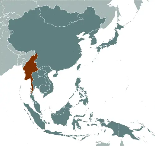
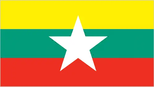
Table of contents
- Background
- Overview
- Google Maps
- Climate
- Geography
- Resources and Land Use
- Population Data
- Economic Data
- Drinking Water Source
- Population, Median Age, Migration, and Citizenship
- Average Number of Childbirths
- Is this country a Safe Destination?
- Healthcare and Infectious Diseases
- Natural Hazards
- The Flag and Other Symbols
- Constitution
- Legal System
- About the Unemployment Rate, Labor Force, and Poverty Line
- About the Budget and Central Government Debt
- Inflation Rate and Prime Lending Rate
- Export/Import Partners and Data
- Renewable Energies Used
- Telecommunication Data, Calling Code
- Transport Infrastructure
- More Interesting Facts
Background
Burma, also known as Myanmar, has a complex history of ethnic diversity and political struggle. Colonized by Britain in the 19th century, it gained independence post-World War II. The country has been marked by efforts of various ethnic and religious minority groups to resist external control. Following a military coup in 1962, General Ne Win and successive military regimes ruled until 2011, when a gradual process of political and economic reforms began. However, the situation remains unstable, especially following the military coup in February 2021.
Overview
Britain colonized Burma in the 19th century and gained independence after World War II. The country is home to various ethnic and religious minority groups, many of whom have resisted external attempts to consolidate control. Burma had experienced military rule, with General Ne Win seizing power in 1962 and ruling until 1988, when a new military regime took over. In 1990, the junta allowed an election, but when the opposition National League for Democracy (NLD) led by Aung San Suu Kyi won by a wide margin, the results were rejected. Suu Kyi was placed under house arrest for two decades. In 2007, protests known as the “Saffron Revolution” erupted against the junta, resulting in violent suppression and arrests. Political and economic reforms gradually began in Burma, with some prisoners being released, ceasefires breaking out with ethnic armed groups, expanded civil liberties, and Suu Kyi entering government in 2012. The NLD won a sweeping electoral victory in 2015, and Suu Kyi became the de facto head of state. However, the NLD government faced criticism for its handling of the military’s actions against the Rohingya population, which were deemed genocidal. In 2020, the military disputed the results of the elections that favored the NLD, leading to a coup in February 2021. Since then, Burma has returned to authoritarian rule, with the detention of Suu Kyi, pro-democracy activists, and widespread repression. In response, members of the ousted parliament formed a shadow National Unity Government (NUG), which includes representatives from the NLD, ethnic minority groups, and civil society. The NUG established the People’s Defense Force (PDF) as a notional army and announced an insurgency against the military junta. As of 2023, PDF groups are actively fighting against the military regime across Burma with varying levels of support from the NUG and ethnic armed groups. The country continues to face political instability, violence, and economic decline.
Official Name: Union of Burma
Capital: Nay Pyi Taw
Population: 57,970,293 (2023 est.)
Total Area: 676,578 sq km
Languages: Burmese (official)
Religions: Buddhist 87.9%, Christian 6.2%, Muslim 4.3%, others
Ethnic Groups: Burman 68%, Shan 9%, Karen 7%, Rakhine 4%, others
Government: Military junta since February 2021 coup
Currency: Kyat (MMK)
Myanmar (Burma) Google Maps
Burma, situated in Southeastern Asia, is a country rich in culture and natural beauty. Google Maps allows users to explore its diverse landscapes, from the bustling streets of Yangon and Mandalay to the serene Inle Lake and the ancient temples of Bagan.
The map below shows Burma’s cities, towns, highways, main roads, streets, and Street Views. To find a location, use the form below, type any city or place, view a simple map, and click the “show map” button.
The Google Maps above shows Burma with its location: Southeast Asia (geographic coordinates: 22 00 N, 98 00 E) and the international borders of Burma; total: 6,522 km. Border countries (total: 5): Bangladesh 271 km, China 2,129 km, India 1,468 km, Laos 238 km, Thailand 2,416 km; furthermore, it’s inland counties boundaries.
The map of Burma, Southeast Asia, is for informational use only. No representation is made or warrantied given any map or content by Driving Directions and Maps site. The user assumes all risks of using this Burma Google Maps and facts/wiki.
Climate
Myanmar (formerly known as Burma) is characterized by a tropical monsoon climate, significantly influencing its geography and the daily lives of its people. Here’s an extended overview of Myanmar’s climate, along with information about its neighboring countries:
- Tropical Monsoon Climate: The monsoon cycles largely dictate Myanmar’s climate. The country experiences three distinct seasons: the hot season, the rainy season, and the cool season.
- Hot Season (March to May):
- During this period, temperatures can rise significantly, often exceeding 40°C (104°F) in some areas, especially in the central and northern regions.
- This season precedes the monsoon and is characterized by high temperatures and low humidity.
- Rainy Season (June to October):
- The southwest monsoon brings heavy rains, accounting for 80-90% of the annual rainfall.
- Coastal regions and western hills receive the heaviest rainfall, with annual totals exceeding 5,000 mm (196.9 inches) in some areas.
- In contrast, the central region, located in the rain shadow of the Arakan Mountains, receives considerably less rainfall.
- Cool Season (November to February):
- This season features milder temperatures and lower humidity.
- Rainfall is significantly less during this period, making it the most comfortable time of year regarding climate.
- Geographical Variation: Myanmar’s climate varies considerably across different regions. The coastal areas, particularly the Rakhine (Arakan) and Tanintharyi (Tenasserim) regions, experience a maritime climate, while the central region, known as the “Dry Zone,” has a more semi-arid climate.
- Impact on Agriculture and Economy:
- The monsoon season is crucial for agriculture, as most farming depends on monsoon rains. Rice, a staple crop, relies heavily on this seasonal rainfall.
- Fluctuations in the monsoon, such as delayed onset or early withdrawal, can significantly impact agricultural yields and, consequently, the economy.
- Climate Change Concerns:
- Biodiversity and Natural Disasters:
- The varied climate supports a rich biodiversity, especially in the tropical forests. However, natural disasters like cyclones and floods can devastate human settlements and natural habitats.
- Environmental Issues: Deforestation and air pollution are significant environmental issues in Myanmar, exacerbated by rapid economic development and urbanization.
Myanmar’s tropical monsoon climate, with its distinct seasonal variations, is critical in shaping its geography, agriculture, and overall way of life. The climate’s impact varies across different regions, influencing everything from biodiversity to economic activities. Additionally, Myanmar faces environmental and climatic challenges that require sustainable management and adaptation strategies.
Geography
Myanmar (formerly known as Burma) boasts a diverse geographical landscape featuring central lowlands surrounded by rugged highlands and significant river systems. Here’s an extended overview of its geography, along with information on its neighboring countries:
Central Lowlands: The central part of Myanmar consists of lowlands, forming the core of the country’s agricultural region, particularly for rice cultivation. This area is dominated by the expansive Irrawaddy (Ayeyarwady) Delta, which is crucial for agriculture due to its fertile alluvial soils.
Irrawaddy River: The Irrawaddy River, Myanmar’s longest river, flows from north to south and is approximately 2,170 kilometers (1,348 miles) long. It is a vital commercial waterway, facilitating transport and trade, and is central to the country’s irrigation and agriculture.
Highland Regions:
- The highland regions encompass the Arakan (Rakhine), Chin, and Shan Hills.
- The Arakan Mountains, along the western coast, separate Myanmar from neighboring Bangladesh and India. Dense forests and rich biodiversity characterize these mountains.
- The Chin Hills in the west and the Shan Plateau in the east are other prominent highlands featuring rugged terrain and elevations that reach over 2,000 meters in some areas.
Shan Hills: The Shan Hills, forming the eastern part of the highlands, include several ranges extending to the borders of China, Laos, and Thailand. This region is known for its scenic beauty, ethnic diversity, and agricultural production, including tea, coffee, and various fruits.
Borders and Surrounding Countries: China is to the north and northeast, Laos is to the east, Thailand is to the southeast, Bangladesh is to the west, and India is to the northwest.
Climate and Geography Interplay: Myanmar’s geography and climate are interlinked, with the highland areas experiencing cooler temperatures and the lowlands being warmer and more humid, particularly in the delta region.
Natural Resources: The country is rich in natural resources, including jade, gems, oil, natural gas, and timber. The highlands, particularly in areas like Kachin State, are known for their jade and gemstone mines.
Biodiversity and Protected Areas: Myanmar’s varied landscape supports diverse ecosystems, from tropical forests in the lowlands to mountainous regions. The country has several protected areas and national parks to preserve its rich biodiversity.
Environmental Challenges: Deforestation, soil erosion, and natural disasters (cyclones and floods) are major environmental challenges. Unsustainable agricultural practices and logging exacerbate these.
Population Distribution: The population distribution in Myanmar is influenced by its geography, with the majority living in the central lowlands and delta regions due to the fertility of the land and the presence of key cities, including Yangon and Mandalay.
Myanmar’s geography, characterized by its central lowlands, rugged highlands, and significant river systems, is pivotal in shaping its agriculture, biodiversity, and population distribution. The interplay between these geographical features and the climate impacts various aspects of life in Myanmar, from economic activities to environmental conservation efforts.
Resources and Land Use
Burma is rich in natural resources like petroleum, timber, tin, antimony, zinc, copper, tungsten, and natural gas. Land use is primarily agricultural, with significant forest coverage.
Population Data
The population is concentrated along coastal areas and near the Irrawaddy River. The country faces challenges of internal displacement due to conflict and natural disasters.
Economic Data
The economy is diverse, with agriculture, industry, and services sectors. The country’s political instability and the COVID-19 pandemic have impacted economic growth.
Drinking Water Source
Improved drinking water sources are accessible to 85.3% of the population, though disparities exist between urban and rural areas.
Population, Median Age, Migration, and Citizenship
The median age is 30.4 years. The country faces a negative net migration rate, reflecting political and economic instability.
Average Number of Childbirths
The total fertility rate is around 2 children born per woman, indicating moderate childbirth.
Is this country a Safe Destination?
Due to ongoing political instability and civil unrest, particularly since the 2021 military coup, safety concerns are significant for travelers.
Healthcare and Infectious Diseases
Healthcare facilities are limited, especially in rural areas. Common diseases include malaria, dengue fever, and hepatitis A.
Natural Hazards
Burma is prone to destructive earthquakes, cyclones, and seasonal flooding.
The Flag and Other Symbols
The national flag consists of three horizontal yellow, green, and red stripes with a large white star. The chinthe (mythical lion) is a national symbol.
Constitution
The current constitution, adopted in 2008, has been controversial, particularly its provisions granting significant power to the military.
Legal System
The legal system is a mix of English common law and customary law. The 2021 military coup has further complicated the legal and judicial landscape.
About the Unemployment Rate, Labor Force, and Poverty Line
The unemployment rate is relatively low; however, poverty remains a significant issue, with a large portion of the population living below the poverty line.
About the Budget and Central Government Debt
The country faces challenges in managing its budget and public debt, exacerbated by political instability and economic sanctions.
Inflation Rate and Prime Lending Rate
Inflation has been a concern, particularly due to political upheavals and economic challenges.
Export/Import Partners and Data
Major exports include natural gas and clothing products, with China being a key export partner. Imports include refined petroleum and broadcasting equipment.
Renewable Energies Used
Burma’s energy sector relies heavily on fossil fuels, though there is potential for hydropower development.
Telecommunication Data, Calling Code
The telecommunication sector is growing, with increasing mobile cellular subscriptions. The country code is +95.
Transport Infrastructure
Transport infrastructure includes a network of roads, railways, and several airports, though development varies across regions.
More Interesting Facts
Myanmar (Burma) is known for its rich cultural heritage, traditional Burmese music and dance, and diverse ethnic communities. However, the country’s political situation remains a challenge, impacting its social and economic development.
Did You Know?
- Ancient Cities: Myanmar is home to several ancient cities, including Bagan, once the capital of a powerful ancient kingdom. The Bagan Archaeological Zone contains over 2,000 Buddhist temples and pagodas built between the 11th and 13th centuries.
- Inle Lake’s Unique Fishermen: Inle Lake is famous for its unique leg-rowing fishermen. They practice a distinctive rowing style, standing at the stern on one leg and wrapping the other leg around the oar.
- Longest Teak Bridge in the World: The U Bein Bridge in Amarapura is the longest teakwood bridge in the world, stretching 1.2 kilometers across the Taungthaman Lake. It was built in the mid-19th century using reclaimed teakwood from a royal palace.
- Largest Book in the World: The Kuthodaw Pagoda in Mandalay houses what is often referred to as the world’s largest book. It consists of 729 marble slabs, each inscribed with Buddhist teachings.
- Golden Rock Pagoda: The Kyaiktiyo Pagoda, also known as Golden Rock, is a famous Buddhist pilgrimage site. The pagoda is built on a gold-leaf-covered boulder precariously perched on the edge of a cliff.
- Diverse Ethnic Groups: Myanmar is one of the most ethnically diverse countries in the world, home to over 135 different ethnic groups, each with its own unique language, culture, and traditions.
- Jade and Gemstones: Myanmar is the world’s largest source of jadeite and produces some of the highest-quality rubies and sapphires.
- Thingyan Water Festival: The Thingyan Water Festival, marking the Burmese New Year, is one of the biggest celebrations in Myanmar. It involves several days of water throwing, symbolizing the washing away of sins and bad luck from the previous year.
- Traditional Skirts: The longyi, a traditional form of dress for both men and women in Myanmar, is a cloth sheet worn around the waist, resembling a skirt.
- Home to Rare Wildlife: Myanmar’s diverse ecosystems are home to many rare species, including the Irrawaddy dolphin and the Myanmar snub-nosed monkey, which was only discovered in 2010.
These fascinating facts about Myanmar showcase its rich cultural heritage, ancient history, and unique traditions, making it a captivating country with a deep and diverse identity.
Many thanks for visiting and sharing this map & country information site!