
 |
 |
 |
| Borderline map of Tajikistan | Location map of Tajikistan | Flag of Tajikistan |
Google Maps and Detailed Facts of Tajikistan (TJ). This page lets you explore Tajikistan and its border countries (Country Location: Central Asia, west of China, south of Kyrgyzstan) through detailed Satellite imagery – fast and easy as never before Google Maps.
Find comprehensive information about this country’s diversity below: Google Maps, geography, economy, science, people, culture, environment, government, and history – All in One Wiki page.
There is also a Street View and free Driving Directions at your service. Your Google Satellite Map Sightseeing in Tajikistan, in Asia, starts here at Driving Directions and Maps.com.
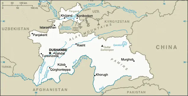
Tajikistan Google Maps & Satellite Maps
The map below shows Tajikistan with its cities, towns, highways, main roads, streets, and Street Views. To find a location, use the form below, type any city or place, view a simple map, and click the “show map” button.
The Google Maps above shows Tajikistan with its location: Asia (geographic coordinates: 39 00 N, 71 00 E) and the international borders of Tajikistan; total: 4,130 km. Border countries (total: 4): Afghanistan 1,357 km, China 477 km, Kyrgyzstan 984 km, Uzbekistan 1,312 km; furthermore, it’s inland counties boundaries.
Hint: Look at the Street view in Tajikistan, or Asia. All you have to do is drag and pull the little yellow man (named: Pegman) on the Google Maps above the desired location. After that, whenever it is available (more than 50 countries globally), blue stripes will appear to show the photos and details from Google’s regularly updated data image base. In case if you have signed in to your Google account currently, you may have a look at the satellite map of this country/area as well.
The map of Tajikistan, Asia, is for informational use only. No representation is made or warrantied given any map or its content by Driving Directions and Maps site. The user assumes all risks of using this Tajikistan Google Maps and facts/wiki.
About Tajikistan in detail
Where is Tajikistan?
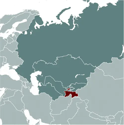
In case Tajikistan is looking on the map under the Coordinates 38 33 N 68 46 E otherwise in Asia, in Central Asia, west of China, south of Kyrgyzstan.
What is the capital city of Tajikistan?
The capital city of Tajikistan is Dushanbe.
What is the time in Dushanbe?
It is 10 hours ahead of Washington, D.C. during Standard Time; the timezone of Dushanbe is UTC+5.
What is the Internet code for Tajikistan?
The Top Level Domain (TLD) for Tajikistan is: .tj
What is the size of Tajikistan?
The territory of Tajikistan is total: 144,100 sq km; land: 141,510 sq km, water: 2,590 sq km.
If we want to describe the size of the territory of Tajikistan is somewhat smaller than Wisconsin.
If we would like to walk around and discover Tajikistan, we can cover a total distance: 4,130 km.
What is the water coverage of Tajikistan?
We have already mentioned what percentage of Tajikistan is covered by water (see below), and this includes 0 km (landlocked country) coastline.
What is the climate like in Tajikistan?
The climate of Tajikistan is mid-latitude continental, hot summers, mild winters: semiarid to polar in the Pamir Mountains.
Geographical data of Tajikistan
Tajikistan elevation; mean elevation: 3,186 m, elevation extremes; lowest point: Syr Darya (Sirdaryo) 300 m, highest point: Qullai Ismoili Somoni 7,495 m.
The specific geographical details of Tajikistan include a mountainous region dominated by the Trans-Alay Range in the north and the Pamirs in the southeast; western Fergana Valley in the north, Kofarnihon and Vakhsh Valleys in the southwest.
Suppose we would like to describe the countries location from a different perspective. In that case, it is safe to say, and easy to read from a map, Tajikistan is a landlocked country; the highest point, Qullai Ismoili Somoni (formerly Communism Peak), was the tallest mountain in the former USSR.
Resources and land use of Tajikistan
The country’s main mined products are hydropower, petroleum, uranium, mercury, brown coal, lead, zinc, antimony, tungsten, silver, and gold. The population partly uses the earlier highlighted land territory and partly left in its natural state: agricultural land: 34.7%; arable land 6.1%; permanent crops 0.9%; permanent pasture 27.7%; forest: 2.9%; other: 62.4% (2011 estimate).
Population data of Tajikistan
The number of inhabitants of Tajikistan is 8,330,946 (July 2016 estimate).
If we examine the population distribution proportion, it is safe to say that the country’s population is concentrated at lower elevations, with perhaps as much as 90% of the people living in valleys; overall density increases from east to west.
If we look at the proportion of the urbanized and barely populated areas, these are the figures: urban population: 26.8% of the total population (2015).
Most of the population in Tajikistan is concentrated in DUSHANBE (capital) 822,000 (2015).
Ethnicity in Tajikistan
According to ethnicity details, the ethnic groups are Tajik 84.3%, Uzbek 13.8% (includes Lakai, Kongrat, Katagan, Barlos, Yuz), other 2% (includes Kyrgyz, Russian, Turkmen, Tatar, Arab) (2010 estimate).
Spoken languages in Tajikistan
The spoken languages in Tajikistan are the following: Tajik (official language), Russian widely used in government and business. Note: different ethnic groups speak Uzbek, Kyrgyz, and Pashto.
What are the most important religions in Tajikistan?
According to this general census, researchers examine the churches: Sunni Muslim 85%, Shia Muslim 5%, other 10% (2003 estimate).
Further population data of Tajikistan
The proportion of gender and age tells a lot about the society as follows 0-14 years: 32.56% (male 1,380,959 / female 1,331,790) 15-24 years: 19.04% (male 804,625 / female 781,469) 25-54 years: 39.79% (male 1,640,657 / female 1,674,198) 55-64 years: 5.37% (male 205,541 / female 241,770) 65 years and over: 3.24% (male 112,279 / female 157,658) (2016 estimate). It also a significant factor in a society the population growth rate, which in the case of Tajikistan is 1.66% (2016 estimate).
The population growth rate is based on two elements, the birth, and the death rate. In Tajikistan the birth rate is 23.8 births / 1,000 population (2016 estimate), the death rate 6.1 deaths / 1,000 population (2016 estimate).
In this day and age in developed societies, the first child borns later compared to the previous centuries and decades, so childbearing is extended. In Tajikistan, the average age of mothers at the first childbirth is N/A.
Although the children’s birth is postponed in the best-case scenario, the parents can still see their kids grow as life expectancy also extended. In the case of Tajikistan, these figures are. With the introduction of modern medicine, vaccinations, and the proper hygienic conditions, the infant mortality rate is in a steep decline. The infant mortality statistics in Tajikistan are the following: N/A. Relevant data is the budget of healthcare, which is in the case of this country is 6.9% of GDP (2014).
Economic data of Tajikistan
Suppose we would like to describe a country. We also have to mention its economy; Tajikistan is a poor, mountainous country with an economy dominated by minerals extraction, metals processing, agriculture, and reliance on citizens’ remittances working abroad. The 1992-97 civil war severely damaged an already weak economic infrastruBecause of a lack of employment opportunities in Tajikistan. More than one million Tajik citizens work abroad – roughly 90% in Russia – supporting families back home through remittances that have been equivalent to nearly 50% of GDP. Since the end of the devastating, five-year civil war, the country has pursued half-hearted reforms and privatizations, but the poor business climate remains a hurdle to attracting investment. Tajikistan has sought to develop its substantial hydroelectricRecent slowdowns in the Russian and Chinese economies, low commodity prices, and currency fluctuations are hampering economic growth in Tajikistan.
GDP is a prominent figure, as all the relevant calculations and statistics are based on it. GDP in Tajikistan is $6.612 billion (2015 estimate).
Another important indicator is the rate of GDP growth, which in Tajikistan is 6% (2016 estimate) 6% (2015 estimate) 6.7% (2014 estimate).
These statistics affect the world economy; remember, in 2015, the Chinese real GDP growth rate was worse than expected; The world markets fall, and the Chinese stock exchange was temporarily suspended.
A further major factor of a country’s economy, the GDP per capita. In Tajikistan this is $3,000 (2016 estimate) $2,900 (2015 estimate) $2,800 (2014 estimate).
In the economy, the Trinity is in common places, such as agriculture, industry, and services.
What are the agricultural products Tajikistan produces?
The main agricultural products of Tajikistan are cotton, grain, fruits, grapes, vegetables; cattle, sheep, goats.
Regarding the economy, the important segments are aluminum, cement, vegetable oil. The crucial and regularly mentioned GDP is based on aluminum, cement, vegetable oil.
Drinking water source in Tajikistan
It is essential to mention that – thanks to the development of the infrastructure -, the rate of potable water improved: urban: 93.1% of the population, rural: 66.7% of the population, total: 73.8% of the population. Unimproved: urban: 6.9% of the people, rural: 33.3% of the population, total: 26.2% of the population (2015 estimate).
The average number of childbirth in Tajikistan
In Tajikistan, the average delivery number is 2.67 children born / woman (2016 estimate).
Population, median age, migration, and citizenship in Tajikistan
The population’s average age is 24.2 years; male: 23.6 years, female: 24.8 years (2016 estimate). The age of adulthood varies in every country of the world in Tajikistan; it is 18 years of age, universal.
When we are experiencing an unprecedented scale of migration and globalization, it is an important factor in the number of new immigrants. In Tajikistan is -1.1 migrant(s) / 1,000 population (2016 estimate). It is important to know how to apply for citizenship: citizenship by birth: no. Citizenship by descent only: at least one parent must be a citizen of Tajikistan. Dual citizenship recognized: no—the residency requirement for naturalization: 5 years or three years of continuous residence before application.
Is Tajikistan a safe destination? Healthcare services and infectious diseases in Tajikistan
Many of the travelers are looking into the healthcare services and infectious diseases of their destinations. In Tajikistan, the hospital beds’ density is 5.5 beds / 1,000 population (2011).
According to the WHO rating regarding contagious diseases in Tajikistan, the degree of risk: high food or waterborne diseases: bacterial diarrhea, hepatitis A, and typhoid fever vectorborne disease: malaria (2016).
However, HIV is not curable but maintainable. Let’s do not forget when the disease surfaced; it was a world threatening condition. Unfortunately, in some countries, it is still very high the number of infected patients and fatalities due to the disease.
In Tajikistan, the number of HIV/AIDS deaths: N/A.
Regarding tourism obesity, not an important issue, but we have to mention health statistics, as it is the plague of the 20th and the 21st century. The rate of obese adults in Tajikistan is 12% (2014).
What are the natural hazards in Tajikistan? Is there any?
The most known natural risk in Tajikistan are earthquakes; floods.
More interesting facts about Tajikistan
A few words about the past, as every country and society, are connected to its history; The Tajik people came under Russian rule in the 1860s and 1870s, but Russia’s hold on Central Asia weakened following the Revolution 1917. Bands of indigenous guerrillas (called “Basmachi”) fiercely contested Bolshevik control of the area, which was not fully reestablished until 1925. Tajikistan was first created as an autonomous republic within Uzbekistan in 1924, but the USSR designated Tajikistan a separate republic in 1929 and transferred to it much of present-day Sughd province. Ethnic Uzbeks form a substantial minority in Tajikistan, and ethnic Tajiks an even larger minority in Uzbekistan. Tajikistan became independent in 1991 following the breakup of the Soviet Union and experienced a civil war between regional factions from 1992 to 1997.
Tajikistan has endured several domestic security incidents since 2010, including armed conflict between government forces and local strongmen in the Rasht Valley and between government forces and criminal groups in Gorno-Badakhshan Autonomous Oblast. In September 2015, government security forces rebuffed attacks led by a former high-ranking official in the Ministry of Defense. President Emomali RAHMON, who came to power during the civil war, used the attacks to ban the main opposition political party in Tajikistan. RAHMON further strengthened his position by having himself designated “Leader of the Nation” and removing term limits on himself through constitutional amendments in a referendum in May 2016. The country remains the poorest in the former Soviet sphere. Tajikistan became a member of the World Trade Organization in March 2013. However, its economy continues to face significant challenges, including dependence on Tajikistan’s remittances in Russia, pervasive corruption, and the opiate trade in neighboring Afghanistan.
In every nation’s memory, some cornerstones placed the country on the timeline of history. The date of declaration of independence of Tajikistan: 9 September 1991 (from the Soviet Union).
The flag and other symbols of Tajikistan
The colors, symbols, and animals on the flag usually have a historical background or an important milestone or memory of the nation.
This case is not an exception either; three horizontal stripes of red (top), a wider stripe of white, and green; a gold crown surmounted by seven gold, five-pointed stars is located in the center of the white stripe; red represents the sun, victory, and the unity of the nation, white stands for purity, cotton, and mountain snows, while green is the color of Islam and the bounty of nature; the crown symbolizes the Tajik people; the seven stars signify the Tajik magic number “seven” – a symbol of perfection and the embodiment of happiness.
Apart from the flag, the symbol of national unity is the national anthem. The anthem’s primary purpose is to share the nation’s core values, endeavors, and patriotic feelings.
National symbols of Tajikistan: crown surmounted by seven, five-pointed stars; national colors: red, white, green.
Constitution of Tajikistan
The existence of the nation is based on the constitution. Some constitutions knew worldwide, like the U.S. Constitution that was accepted on the 17th of September 1787, in Philadelphia, the United States of America’s Constitution.
It is not related to the declaration of independence that was stolen by Nicolas Cage in the movie National Treasure 🙂
What is the legal system of Tajikistan?
Most of the time, the legal system of a country is the focus of lawyers. It is a common fact that there are two main approaches in the world, “the law in books” and “the law in action.”
In the Anglo-Saxon world, the practice is the “law in action,” while in the rest of the world, the law is based on Roman law, the “law in books.”
The legal system of Tajikistan is a civil law system.
It was Aristotle who founded the Theory of 3 separations of powers. In his view, these are the council of public affairs, the magistrates, and the justice system. The age of enlightenment was the time when terminologies have defined the way we still use them. In most democratic countries, the three authorities separated from each other. In dictatorships, the rules usually interweaved in one hand.
About the legislative branch of Tajikistan, we can highlight the following structures bicameral Supreme Assembly or Majlisi Oli consists of the National Assembly or Majlisi Milli (34 seats; 25 members indirectly elected by local representative assemblies or majlisi, eight appointed by the president, and one reserved for the former president; members serve 5-year terms) and the Assembly of Representatives or Majlisi Namoyandagon (63 seats; 41 members directly elected in single-seat constituencies by two-round absolute majority vote and 22 directly elected in a single nationwide constituency by proportional representation vote; members serve 5-year terms).
About the unemployment rate, labor force, and poverty line in Tajikistan
One of the major problems of the 21st-century economy is unemployment. Governments are struggling to maintain a low level of the unemployment rate. Still, as a result of automation, the cheap 3rd world labor, and the outsourcing of workflow, these attempts fail. In Tajikistan, the labor force is 2.209 million (2013 estimate). Please bear in mind that the population in Tajikistan is total: 32.8 deaths / 1,000 live births; male: 37.1 deaths / 1,000 live births, female: 28.4 deaths / 1,000 live births (2016 estimate) – as we already mentioned above.
The rate of unemployment in Tajikistan is 2.5% (2013 estimate).
Widely known that the gap between the rich and poor is widening on an enormous scale.
According to the 2017 shocking Oxfam report, the most affluent eight people’s fortune is equal to the wealth of the poorest half of the world’s population.
In Tajikistan, the households’ income and consumption compared to the entire population: lowest 10%: N/A% highest 10%: N/A% (2009 estimate).
Another widely used indicator is the so-called GINI index, which measures the inequalities of statistical dispersion, but is mainly used for measuring the sharing of income and fortune.
The GINI index was named after its founder Corrado Gini, an Italian economist. Gini index has grades between 0-1, but often it is used on a percentage basis. It is 0 if the examined criteria territorial distribution is equal. It is one of the criteria concentrated on the territory. In Tajikistan, the GINI index is .32,6 (2006).
The states usually set up a poverty line, which is more or less, is a subjective measure. It varies by country; its base is often the minimum pension, the incomes of the most deficient 20 percent, the X percent of income per capita Etc.
In Tajikistan, the poverty line people are the lowest 10%: N/A% highest 10%: N/A% (2009 estimate).
About the budget and central governments debt of Tajikistan
The available budget mainly defines the state’s economy. The budget of Tajikistan is; revenues: $1.841 billion, expenditures: $1.985 billion (2016 estimate). Taxes and other revenues are 27.8% of GDP (2016 estimate).
The budget deficit (Budget surplus (+) or deficit (-)) is N/A.
The fiscal year in Tajikistan is the calendar year.
In the country’s economy, we have to consider the public debt. Public debt is the consolidated sum of the state’s local, federal, and central government debt.
Inflation rate and prime lending rate in Tajikistan
A few further interesting and relevant economic data are the following; Inflation rate: 8% (2016 estimate), 10.8% (2015 estimate), and the rate of the Commercial bank prime lending rate: 26% (31 December 2016 estimate).
Export/import partners and data of Tajikistan
Tajikistan, with the export of products, industrial tools, and other services, generates revenue. The export value in Tajikistan is $530.8 million (2016 estimate), $572 million (2015 estimate). The total revenue of these activities: aluminum, electricity, cotton, fruits, vegetable oil, textiles.
The most important export partners of Tajikistan are Turkey 19.7%, Kazakhstan 17.6%, Switzerland 13.7%, Iran 8.7%, Afghanistan 7.5%, Russia 5.1%, China 4.9%, Italy 4.8% (2015).
The most important imported products are petroleum products, aluminum oxide, machinery and equipment, foodstuffs, and the countries where the import is coming: China 42.3%, Russia 17.9%, Kazakhstan 13.1%, Iran 4.7% (2015).
Renewable energies used in Tajikistan
To suppress the pollution of the environment, renewable energies have to replace the fossil energy. The more the proportion of renewable energies in a country means more effort against pollution. Tajikistan, the indicator of how much of the country’s produced energy is coming from the hydroelectric source, is 91% of total installed capacity (2013 estimate).
To indicate how much another renewable energy produced is 0% of total installed capacity (2013 estimate).
Telecommunication data of Tajikistan, calling code
To maintain the economy, the development of a reliable and modern telecommunications infrastructure is crucial. We can say the following about Tajikistan; foreign investment in the telephone system has resulted in major improvements; conversion of the existing fixed network from analog to digital was completed in 2012domestic: fixed-line availability has not changed significantly since 1998, while mobile-cellular subscribership, aided by competition among multiple operators, has expanded rapidly; coverage now extends to all major cities and towns. International: country code – 992; linked by cable and microwave radio relay to other CIS republics and by leased connections to the Moscow international gateway switch; Dushanbe linked by Intelsat to international gateway switch in Ankara (Turkey); satellite earth stat (2016).
Transport infrastructure in Tajikistan
In the 21st century, we often say that the world has become small and there are no distances anymore. With widespread air travel when (sometimes) there are no visa restrictions, it is easy to reach other countries, but if the distance is not too long, we can also use railway or water transportation.
The number of airports in Tajikistan: 24 (2013), and the number of heliports: N/A.
The total length of the roadways in Tajikistan: total: 27,767 km (2000).
The total length of the waterways in Tajikistan: 200 km (along the Vakhsh River) (2011).
Are you traveling to Tajikistan?
If you plan to travel by plane to Tajikistan, try our air ticket comparison site, where you can choose from hundreds of carriers and offers. Our application is scanning the market and shows you the best and the cheapest deals without any extra charge or commission.
Are you looking for a hotel, apartment another kind of accommodation in Tajikistan, Asia? We are here to help you to find your accommodation from budget to luxury. Our search engine is scanning, regularly updating data from hundreds of accommodation websites and more than a million offers. You can quickly and easily find your hotel stay anywhere in the world, without any extra charge or commission.
Facts & data about Tajikistan
Name of the country: conventional long way: the Republic of Tajikistan, traditional short form: Tajikistan, local long form: Jumhurii Tojikiston, local short state: Tojikiston, former: Tajik Soviet Socialist Republic, etymology: the Persian suffix “-stan” means “place of” or “country,” so the word Tajikistan literally means “Land of the Tajik (people).”
| Abbreviation: Tajikistan | Geographic coordinates: 39 00 N, 71 00 E |
Country Location: Asia |
| Capital of Tajikistan: Dushanbe | GPS of the Capital: 38 33 N 68 46 E |
Position: Central Asia, west of China, south of Kyrgyzstan |
| Land area: total: 144,100 sq km; land: 141,510 sq km, water: 2,590 sq km | Terrain: mountainous region dominated by the Trans-Alay Range in the north and the Pamirs in the southeast; western Fergana Valley in north, Kofarnihon and Vakhsh Valleys in southwest |
Area comparative: somewhat smaller than Wisconsin |
| Population: 8,330,946 (July 2016 estimate) | Population grow rate: 1.66% (2016 estimate) | Sex ratio: at birth: 1.05 male(s) / female, 0-14 years: 1.04 male(s) / female, 15-24 years: 1.03 male(s) / female, 25-54 years: 0.98 male(s) / female, 55-64 years: 0.85 male(s) / female, 65 years and over: 0.72 male(s) / female, total population: 0.99 male(s) / female (2016 estimate) |
| Exports: $530.8 million (2016 estimate), $572 million (2015 estimate) | Imports: $2.34 billion (2016 estimate), $2.825 billion (2015 estimate) | Import partners: China 42.3%, Russia 17.9%, Kazakhstan 13.1%, Iran 4.7% (2015) |
| Urbanization: urban population: 26.8% of the total population (2015) | Major urban area(s): DUSHANBE (capital) 822,000 (2015) | Median age: total: 24.2 years; male: 23.6 years, female: 24.8 years (2016 estimate) |
| Internet users: total: 1.555 million. Percent of the population: 19% (July 2015 estimate) | Telephones (fixed-lines): total subscriptions: 457,000. Subscriptions per 100 inhabitants: 6 (July 2015 estimate) | Telephones (mobile, cellular): total: 8.489 million. Subscriptions per 100 inhabitants: 104 (July 2015 estimate) |
| Unemployment rate: 2.5% (2013 estimate) | Nationality: Tajikistani(s) adjective: Tajikistani | National holidays: Independence Day (or National Day), 9 September (1991) |
| Life expectancy at birth: total population: 67.7 years. Male: 64.6 years, female: 71 years (2016 estimate) | Total fertility rate: 2.67 children born / woman (2016 estimate) | Birthrate: 23.8 births / 1,000 population (2016 estimate) |
| Literacy: age 15 and over can read and write. Total population: 99.8%; male: 99.8%, female: 99.7% (2015 estimate) | Legal system: civil law system | Suffrage: 18 years of age, universal |
| Industries: aluminum, cement, vegetable oil | Industrial production growth rate: 0.8% (2016 estimate) | GDP real growth rate: 6% (2016 estimate) 6% (2015 estimate) 6.7% (2014 estimate) |
Do you like this Tajikistan Google Maps & country information page?
Please do us a favor: Share or like this page using the icons at the top of the page. We also do encourage you to visit our Facebook page for more travel and country related information.
Many thanks for visiting and sharing this map & country information site!