
 |
 |
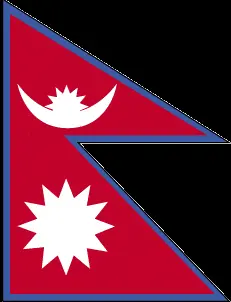 |
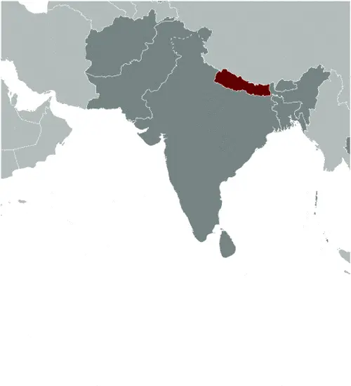
| Borderline map of Nepal | Location map of Nepal | Flag of Nepal |
Google Maps and Detailed Facts of Nepal (NP). This page lets you explore Nepal and its border countries (Country Location: Southern Asia, between China and India) through detailed Satellite imagery – fast and easy as never before Google Maps.
Find comprehensive information about this country’s diversity below: Google Maps, geography, economy, science, people, culture, environment, government, and history – All in One Wiki page.
There is also a Street View and free Driving Directions at your service. Your Google Satellite Map Sightseeing in Nepal, in Asia, starts here at Driving Directions and Maps.com.
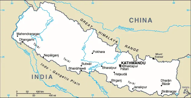
Nepal Google Maps & Satellite Maps
The map below shows Nepal with its cities, towns, highways, main roads, streets, and Street Views. To find a location, use the form below, type any city or place, view a simple map, and click the “show map” button.
The Google Maps above shows Nepal with its location: Asia (geographic coordinates: 28 00 N, 84 00 E) and the international borders of Nepal; total: 3,159 km. Border countries (total: 2): China 1,389 km, India 1,770 km; furthermore, it’s inland counties boundaries.
Hint: Look at the Street view in Nepal or Asia. All you have to do is drag and pull the little yellow man (named: Pegman) on the Google Maps above the desired location. After that, whenever it is available (more than 50 countries globally), blue stripes will appear to show the photos and details from Google’s regularly updated data image base. In case if you have signed in to your Google account currently, you may have a look at the satellite map of this country/area as well.
The map of Nepal, Asia, is for informational use only. No representation is made or warrantied given any map or its content by Driving Directions and Maps site. The user assumes all risks of using this Nepal Google Maps and facts/wiki.
About Nepal in detail
Where is Nepal?
Nepal, in case, if you are looking on the map under the Coordinates 27 43 N 85 19 E otherwise in Asia, in Southern Asia, between China and India.
What is the capital city of Nepal?
The capital city of Nepal is Kathmandu.
What is the time in Kathmandu?
It is 10.75 hours ahead of Washington, D.C. during Standard Time; Kathmandu’s timezone is UTC+5.75.
What is the Internet code for Nepal?
The Top Level Domain (TLD) for Nepal is: .np
What is the size of Nepal?
The territory of Nepal is total: 147,181 sq km; land: 143,351 sq km, water: 3,830 sq km.
If we want to describe the size of the territory of Nepal is slightly larger than Arkansas.
If we would like to walk around and discover Nepal, we can cover a total distance: 3,159 km.
What is the water coverage of Nepal?
We have already mentioned what percentage of Nepal is covered by water (see below), and this includes 0 km (landlocked country) coastline.
What is the climate like in Nepal?
Nepal’s climate varies from cool summers and severe winters in the north to subtropical summers and mild winters in the south.
Geographical data of Nepal
The elevation of Nepal; mean elevation: 2,565 m, elevation extremes; lowest point: Kanchan Kalan 70 m, highest point: Mount Everest 8,850 m.
Nepal’s specific geographical details include Tarai or flat river plain of the Ganges in the south; central hill region with the rugged Himalayas in the north.
Suppose we would like to describe the countries location from a different perspective. In that case, it is safe to say, and easy to read from a map, Nepal is a landlocked country; strategic location between China and India; contains eight of the world’s ten highest peaks, including Mount Everest and Kanchenjunga – the world’s tallest and third tallest mountains – on the borders with China and India respectively.
Resources and land use of Nepal
The country’s main mined products are quartz, water, timber, hydropower, scenic beauty, small lignite deposits, copper, cobalt, and iron ore. The population partly uses the earlier highlighted land territory and partly left in its natural state: agricultural land: 28.8%; arable land 15.1%; permanent crops 1.2%; permanent pasture 12.5%; forest: 25.4%; other: 45.8% (2011 estimate).
Population data of Nepal
The number of inhabitants of Nepal is 29,033,914 (July 2016 estimate).
If we examine the proportion of the population distribution, it is safe to say that N/A.
If we look at the proportion of the urbanized and barely populated areas, these are the figures: urban population: 18.6% of the total population (2015).
Most of the population in Nepal is concentrated in KATHMANDU (capital) 1.183 million (2015).
Ethnicity in Nepal
According to ethnicity details, the ethnic groups are Chhettri 16.6%, Brahman-Hill 12.2%, Magar 7.1%, Tharu 6.6%, Tamang 5.8%, Newar 5%, Kami 4.8%, Muslim 4.4%, Yadav 4%, Rai 2.3%, Gurung 2%, Damai/Dholii 1.8%, Thakuri 1.6%, Limbu 1.5%, Sarki 1.4%, Teli 1.4%, Chamar/Harijan/Ram 1.3%, Koiri/Kushwaha 1.2%, other 19%note: 125 caste/ethnic groups were reported in the 2011 national census (2011 estimate).
The spoken languages in Nepal are the following: Nepali (official language) 44.6%, Maithali 11.7%, Bhojpuri 6%, Tharu 5.8%, Tamang 5.1%, Newar 3.2%, Magar 3%, Bajjika 3%, Urdu 2.6%, Avadhi 1.9%, Limbu 1.3%, Gurung 1.2%, other 10.4%, unspecified 0.2%. Note: 123 languages reported as mother tongue in 2011 national census; many in government and business also speak English (2011 estimate).
What are the most important religions in Nepal?
During the general census, researchers examine the churches, according to this: Hindu 81.3%, Buddhist 9%, Muslim 4.4%, Kirant 3.1%, Christian 1.4%, other 0.5%, unspecifed 0.2% (2011 estimate).
Further population data of Nepal
The proportion of gender and age tells a lot about the society as follows 0-14 years: 30.93% (male 4,646,048 / female 4,333,105) 15-24 years: 21.86% (male 3,176,158 / female 3,169,721) 25-54 years: 35.99% (male 4,707,264 / female 5,740,985) 55-64 years: 6.22% (male 877,288 / female 927,202) 65 years and over: 5.02% (male 723,523 / female 732,620) (2016 estimate). It also a significant factor in a society the population growth rate, which in the case of Nepal is 1.24% (2016 estimate).
The population growth rate is based on two elements, the birth and the death rate. In Nepal the birth rate is 19.9 births / 1,000 population (2016 estimate), the death rate 5.7 deaths / 1,000 population (2016 estimate).
In this day and age in developed societies, the first child borns later compared to the previous centuries and decades, so childbearing is extended. In Nepal, the average age of mothers at the first childbirth is N/A.
Although the children’s birth is postponed in the best-case scenario, the parents can still see their kids grow as life expectancy also extended. In the case of Nepal, these figures are. With the introduction of modern medicine, vaccinations, and the proper hygienic conditions, the infant mortality rate is in a steep decline. The infant mortality statistics in Nepal are the following: N/A. Relevant data is the budget of healthcare, which is in this country’s case is 5.8% of GDP (2014).
Economic data of Nepal
Suppose we would like to describe a country. We also have to mention its economy; Nepal is among the poorest and least developed countries globally, with about one-quarter of its population living below the poverty line. Nepal is heavily dependent on remittances, which amount to as much as 29% of GDP. Nepal has considerable scope for exploiting its potential in hydropower, with an estimated 42,000 MW of commercially feasible capacity. Nepal and India signed trade and investment agreements in 2014 that increase Nepal’s hydropower potential. Nepal was hit by massive earthquakes in early 2015, which damaged or destroyed infrastructure and homes and set back economic development. Political gridlock in the past several years and recent public protests, predominantly in the southern Tarai region.
GDP is a prominent figure, as all the relevant calculations and statistics are based on it. GDP in Nepal is $21.15 billion (2015 estimate).
Another important indicator is the rate of GDP growth, which in Nepal is 0.6% (2016 estimate), 2.7% (2015 estimate) 6% (2014 estimate).
These statistics affect the world economy; remember, in 2015, the Chinese real GDP growth rate was worse than expected; The world markets fall, and the Chinese stock exchange was temporarily suspended.
A further major factor of a country’s economy, the GDP per capita. In Nepal this is $2,500 (2016 estimate) $2,500 (2015 estimate) $2,500 (2014 estimate).
In the economy, the Trinity is in common places, such as agriculture, industry, and services.
What are the agricultural products Nepal produces?
Nepal’s main agricultural products are pulses, rice, corn, wheat, sugarcane, jute, root crops, milk, and water buffalo meat.
The essential segments are tourism, carpets, textiles, small rice, jute, sugar, and oilseed mills, cigarettes, cement, and brick production.
Drinking water source in Nepal
It is essential to mention that – thanks to the development of the infrastructure -, the rate of potable water improved: urban: 90.9% of the population, rural: 91.8% of the people, total: 91.6% of the population. Unimproved: urban: 9.1% of the population, rural: 8.2% of the people, total: 8.4% of the population (2015 estimate).
The average number of childbirth in Nepal
In Nepal, the average delivery number is 2.18 children born / woman (2016 estimate).
Population, median age, migration, and citizenship in Nepal
The population’s average age is 23.6 years; male: 22.4 years, female: 24.8 years (2016 estimate). The age of adulthood varies in every country of the world in Nepal; it is 18 years of age, universal.
When we are experiencing an unprecedented scale of migration and globalization, it is an important factor in the number of new immigrants. In Nepal is -1.9 migrant(s) / 1,000 population (2016 estimate). It is important to know how to apply for citizenship: citizenship by birth: yes. Citizenship by descent: yes. Dual citizenship recognized: no—residency requirement for naturalization: 15 years.
Is Nepal a safe destination? Healthcare services and infectious diseases in Nepal
Many of the travelers are looking into the healthcare services and infectious diseases of their destinations. In Nepal, the hospital beds’ density is five beds / 1,000 population (2006).
According to the WHO rating regarding Nepal’s contagious diseases, the degree of risk: high food or waterborne diseases: bacterial diarrhea, hepatitis A and E, and typhoid fever vectorborne disease: Japanese encephalitis, malaria, and dengue fever (2016).
However, HIV is not curable but maintainable. Let’s do not forget when the disease surfaced; it was a world threatening condition. Unfortunately, in some countries, it is still very high the number of infected patients and fatalities due to the disease.
In Nepal, the number of HIV/AIDS deaths: N/A.
Regarding tourism obesity, not an important issue, but we have to mention health statistics, as it is the plague of the 20th and the 21st century. The rate of obese adults in Nepal is 2.9% (2014).
What are the natural hazards in Nepal? Is there any?
Nepal’s most known natural risk is severe thunderstorms, flooding, landslides, drought, and famine, depending on the summer monsoons’ timing, intensity, and duration.
More interesting facts about Nepal
A few words about the past, as every country and society, are connected to its history; During the late 18th-early 19th centuries, Gorkha’s principality united many of the other principalities and states of the sub-Himalayan region into the Nepalese Kingdom. Nepal retained its independence following the Anglo-Nepalese War of 1814-16, and the subsequent peace treaty laid the foundations for two centuries of amicable relations between Britain and Nepal. (The Brigade of Gurkas continues to serve in the British Army to the present day.) In 1951, the Nepali monarch ended the century-old system of rule by hereditary premiers and instituted a cabinet system that brought political parties into the government. That arrangement lasted until 1960, when political parties were again banned but were reinstated in 1990 to establish a multiparty democracy within a constitutional monarchy framework. An insurgency led by Maoists broke out in 1996.
The ensuing 10-year civil war between Maoist and government forces witnessed the cabinet and parliament’s dissolution and the king’s re-assumption of absolute power in 2002. A peace accord in 2006 led to the promulgation of an interim constitution in 2007. Following a nationwide Constituent Assembly (CA) election in 2008, the newly formed CA declared Nepal a federal democratic republic, abolished the monarchy, and elected its first president. After the CA failed to draft a constitution by a May 2012 deadline set by the Supreme Court, then-Prime Minister Baburam BHATTARAI dissolved the CA. Months of negotiations ensued until March 2013, when the major political parties agreed to create an interim government headed by then-Chief Justice Khil Raj REGMI with a mandate to hold elections for a new CA. In November 2013, elections were held in which the Nepali Congress won the largest share of seats in the CA and in February 2014 formed a coalition government with the second place Communist Party of Nepal-Unified Marxist-Leninist and with Nepali Congress President Sushil KOIRALA as prime minister. Nepal’s new constitution came into effect in September 2015.
In every nation’s memory, some cornerstones placed the country on the timeline of history. The date of declaration of independence of Nepal: 1768 (unified by Prithvi Narayan SHAH).
The flag and other symbols of Nepal
The colors, symbols, and animals on the flag usually have a historical background or an important milestone or memory of the nation.
This case is not an exception either; red with a blue border around the unique shape of two overlapping right triangles; the smaller, upper triangle, bears a white stylized moon and the larger, lower triangle displays a white 12-pointed sun; the color red represents the rhododendron (Nepal’s national flower) and is a sign of victory and bravery, the blue border signifies peace and harmony; the two right triangles are a combination of two single pennons (pennants) that originally symbolized the Himalaya Mountains while their charges represented the families of the king (upper) and the prime minister, but today they are understood to denote Hinduism and Buddhism, the country’s two main religions; the moon represents the serenity of the Nepalese people and the shade and cool weather in the Himalayas, while the sun depicts the heat and higher temperatures of the lower parts of Nepal; the moon and the sun are also said to express the hope that the nation will endure as long as these heavenly bodies. Note: Nepal is the only country in the world whose flag is not rectangular or square.
Apart from the flag, the symbol of national unity is the national anthem. The anthem’s primary purpose is to share the nation’s core values, endeavors, and patriotic feelings.
National symbols of Nepal: rhododendron blossom; national color: red.
Constitution of Nepal
The existence of the nation is based on the constitution. Some constitutions knew worldwide, like the U.S. Constitution that was accepted on the 17th of September 1787, in Philadelphia, the United States of America’s Constitution.
It is not related to the declaration of independence that was stolen by Nicolas Cage in the movie National Treasure 🙂
What is the legal system of Nepal?
Most of the time, the legal system of a country is the focus of lawyers. It is a common fact that there are two main approaches in the world, “the law in books” and “the law in action.”
In the Anglo-Saxon world, the practice is the “law in action,” while in the rest of the world, the law is based on Roman law, the “law in books.”
The legal system of Nepal is English common law and Hindu legal concepts.
It was Aristotle who founded the Theory of 3 separations of powers. In his view, these are the council of public affairs, the magistrates, and the justice system. The age of enlightenment was the time when terminologies have defined the way we still use them. In most democratic countries, the three authorities separated from each other. In dictatorships, the rules usually interweaved in one hand.
About the legislative branch of Nepal, we can highlight the following structures unicameral Constituent Assembly or Sambidhan Sabha (601 seats; 240 members directly elected in single-seat constituencies by simple majority vote, 335 directly elected in a single nationwide constituency by proportional representation (PR) vote and 26 appointed by the cabinet (Council of Ministers); note – political parties allocated more than 30 percent of the PR seats are obliged to follow specified quotas for ethnic groups and within them equal percentages of men and women.
About the unemployment rate, labor force, and poverty line in Nepal
One of the major problems of the 21st-century economy is unemployment. Governments are struggling to maintain a low level of the unemployment rate. Still, as a result of automation, the cheap 3rd world labor, and the outsourcing of workflow, these attempts fail. In Nepal, the labor force is 15.2 million (2013 estimate). Please bear in mind that the population in Nepal is total: 28.9 deaths / 1,000 live births; male: 30.2 deaths / 1,000 live births, female: 27.5 deaths / 1,000 live births (2016 estimate) – as we already mentioned above.
The rate of unemployment in Nepal is 46% (2008 estimate).
Widely known that the gap between the rich and poor is widening on an enormous scale.
According to the 2017 shocking Oxfam report, the most affluent eight people’s fortune is equal to the wealth of the poorest half of the world’s population.
The households’ income and consumption in Nepal compared to the entire population: lowest 10%: 3.2% highest 10%: 29.5% (2011).
Another widely used indicator is the so-called GINI index, which measures the inequalities of statistical dispersion, but is mainly used for measuring the sharing of income and fortune.
The GINI index was named after its founder Corrado Gini, an Italian economist. Gini index has grades between 0-1, but often it is used on a percentage basis. It is 0 if the examined criteria territorial distribution is equal. It is one of the criteria concentrated on the territory. In Nepal, the GINI index is .32,8 (2010).
The states usually set up a poverty line, which is more or less, is a subjective measure. It varies by country; its base is often the minimum pension, the incomes of the most deficient 20 percent, the X percent of income per capita Etc.
In Nepal, the poverty line people are the lowest 10%: 3.2% highest 10%: 29.5% (2011).
About the budget and central governments debt of Nepal
The available budget mainly defines the state’s economy. Nepal’s budget is; revenues: $4.848 billion, expenditures: $5.452 billion (2016 estimate). Taxes and other revenues are 22.9% of GDP (2016 estimate).
The budget deficit (Budget surplus (+) or deficit (-)) is N/A.
The fiscal year in Nepal is 16 July – 15 July.
In the country’s economy, we have to consider the public debt. Public debt is the consolidated sum of the state’s local, federal, and central government debt.
Inflation rate and prime lending rate in Nepal
A few further interesting and relevant economic data are the following; Inflation rate: 9.1% (2016 estimate), 7.9% (2015 estimate), and the rate of the Commercial bank prime lending rate: 9.8% (31 December 2016 estimate).
Export/import partners and data of Nepal
Nepal, with the export of products, industrial tools, and other services, generates revenue. The export value in Nepal is: $898.4 million (2016 estimate), $813.1 million (2015 estimate). The total revenue of these activities: clothing, pulses, carpets, textiles, juice, jute goods.
Nepal’s most important export partners are India 61.3%, the US 9.4% (2015).
The most important imported products are petroleum products, machinery and equipment, gold, electrical goods, medicine, and the countries from where the import is coming: India 61.5%, China 15.4% (2015).
Renewable energies used in Nepal
To suppress the pollution of the environment, renewable energies have to replace the fossil energy. The more the proportion of renewable energies in a country means more effort against pollution. Nepal, the indicator of how much of the country’s produced energy is coming from the hydroelectric source, is 92.5% of total installed capacity (2012 estimate).
To indicate how much another renewable energy produced is 0% of total installed capacity (2012 estimate).
Telecommunication data of Nepal, calling code
To maintain the economy, the development of a reliable and modern telecommunications infrastructure is crucial. We can say the following about Nepal; poor telephone and telegraph service; fair radiotelephone communication service and mobile-cellular telephone network domestic: mobile-cellular telephone subscribership base is increasing with roughly 90% of the population living in areas covered by mobile carriers. International: country code – 977; radiotelephone communications; microwave and fiber landlines to India; satellite earth station – 1 Intelsat (Indian Ocean) (2015).
Transport infrastructure in Nepal
In the 21st century, we often say that the world has become small and there are no distances anymore. With widespread air travel when (sometimes) there are no visa restrictions, it is easy to reach other countries, but if the distance is not too long, we can also use railway or water transportation.
The number of airports in Nepal: 47 (2013), and the number of heliports: N/A.
The total length of the roadways in Nepal: total: 10,844 km, paved: 4,952 km, unpaved: 5,892 km (2010).
The total length of the waterways in Nepal: N/A.
Are you traveling to Nepal?
If you plan to travel by plane to Nepal, try our air ticket comparison site, where you can choose from hundreds of carriers and offers. Our application is scanning the market and shows you the best and the cheapest deals without any extra charge or commission.
Are you looking for a hotel, apartment another kind of accommodation in Nepal, Asia? We are here to help you to find your accommodation from budget to luxury. Our search engine is scanning, regularly updating data from hundreds of accommodation websites and more than a million offers. You can quickly and easily find your hotel stay anywhere in the world, without any extra charge or commission.
Facts & data about Nepal
Name of the country: conventional long way: the Federal Democratic Republic of Nepal, traditional short form: Nepal, local long form: Sanghiya Loktantrik Ganatantra Nepal, local short state: Nepal, etymology: the Newar people of the Kathmandu Valley and surrounding areas apparently gave their name to the country; the terms “Nepal,” “Newar,” “Nepar,” and “Newal” are phonetically different forms of the same word.
| Abbreviation: Nepal | Geographic coordinates: 28 00 N, 84 00 E |
Country Location: Asia |
| Capital of Nepal: Kathmandu | GPS of the Capital: 27 43 N 85 19 E |
Position: Southern Asia, between China and India |
| Land area: total: 147,181 sq km; land: 143,351 sq km, water: 3,830 sq km | Terrain: Tarai or flat river plain of the Ganges in south; central hill region with rugged Himalayas in north |
Area comparative: slightly larger than Arkansas |
| Population: 29,033,914 (July 2016 estimate) | Population grow rate: 1.24% (2016 estimate) | Sex ratio: at birth: 1.04 male(s) / female, 0-14 years: 1.07 male(s) / female, 15-24 years: 1 male(s) / female, 25-54 years: 0.82 male(s) / female, 55-64 years: 0.95 male(s) / female, 65 years and over: 0.86 male(s) / female, total population: 0.95 male(s) / female (2016 estimate) |
| Exports: $898.4 million (2016 estimate), $813.1 million (2015 estimate) | Imports: $7.116 billion (2016 estimate), $6.511 billion (2015 estimate) | Import partners: India 61.5%, China 15.4% (2015) |
| Urbanization: urban population: 18.6% of the total population (2015) | Major urban area(s): KATHMANDU (capital) 1.183 million (2015) | Median age: total: 23.6 years; male: 22.4 years, female: 24.8 years (2016 estimate) |
| Internet users: total: 5.547 million. Percent of the population: 17.6% (July 2015 estimate) | Telephones (fixed-lines): total subscriptions: 846,940. Subscriptions per 100 inhabitants: 3 (July 2015 estimate) | Telephones (mobile, cellular): total: 27.516 million. Subscriptions per 100 inhabitants: 87 (July 2015 estimate) |
| Unemployment rate: 46% (2008 estimate) | Nationality: Nepali (singular and plural) adjective: Nepali | National holidays: Republic Day, 28 May (2008), the abdication of Gyanendra SHAH, last Nepalese monarch, and the establishment of a federal republic |
| Life expectancy at birth: total population: 70.7 years. Male: 70.1 years, female: 71.3 years (2016 estimate) | Total fertility rate: 2.18 children born / woman (2016 estimate) | Birthrate: 19.9 births / 1,000 population (2016 estimate) |
| Literacy: age 15 and over can read and write. Total population: 63.9%; male: 76.4%, female: 53.1% (2015 estimate) | Legal system: English common law and Hindu legal concepts | Suffrage: 18 years of age, universal |
| Industries: tourism, carpets, textiles; small rice, jute, sugar, and oilseed mills; cigarettes, cement and brick production | Industrial production growth rate: -6.3% (2016 estimate) | GDP real growth rate: 0.6% (2016 estimate) 2.7% (2015 estimate) 6% (2014 estimate) |
Do you like this Nepal Google Maps & country information page?
Please do us a favor: Share or like this page using the icons at the top of the page. We also do encourage you to visit our Facebook page for more travel and country related information.
Many thanks for visiting and sharing this map & country information site!