
Google Maps and Detailed Facts of Bangladesh (BG). This page lets you explore Bangladesh and its border countries (Country Location: Southern Asia, bordering the Bay of Bengal, between Burma and India) through detailed Satellite imagery – fast and easy as never before Google Maps.
Find comprehensive information about this country’s diversity below: Google Maps, geography, economy, science, people, culture, environment, government, and history – All in One Wiki page.
There is also a Street View and free Driving Directions at your service. Your Google Satellite Map Sightseeing in Bangladesh in Asia starts at Driving Directions and Maps.com.
About Bangladesh in detail
| Borderline map of Bangladesh | Location map of Bangladesh | Flag of Bangladesh |
|---|---|---|
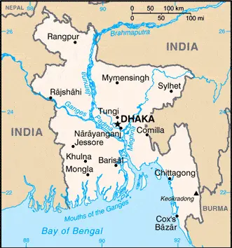 |  | 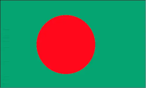 |
Table of contents
- Background
- Overview
- Google Maps
- Climate
- Geography
- Resources and Land Use
- Population Data
- Economic Data
- Drinking Water Source
- Population, Median Age, Migration, and Citizenship
- Average Number of Childbirths
- Is this country a Safe Destination?
- Healthcare and Infectious Diseases
- Natural Hazards
- The Flag and Other Symbols
- Constitution
- Legal System
- About the Unemployment Rate, Labor Force, and Poverty Line
- About the Budget and Central Government Debt
- Inflation Rate and Prime Lending Rate
- Export/Import Partners and Data
- Renewable Energies Used
- Telecommunication Data, Calling Code
- Transport Infrastructure
- More Interesting Facts
Background
Bangladesh’s history is deeply intertwined with the confluence of the Ganges and Brahmaputra River systems. Initially an outpost of various empires, the region saw significant Muslim conversions and settlements from the 10th century, mainly by Arab and Persian traders and preachers. Europeans established trading posts in the 16th century, and the area, known as Bengal, became a part of British India. The eastern Muslim-majority wing of Pakistan became East Pakistan after the 1947 partition. The independence movement led by the Awami League, supported by India, culminated in the liberation war, resulting in Bangladesh’s independence in 1971. Political upheavals, military coups, and the alternation of power between the Awami League and Bangladesh Nationalist Party have marked the post-independence era.
Overview
Today, Bangladesh stands as a testimony to remarkable resilience and growth. It has made significant strides in reducing poverty, improving maternal and child health, and achieving food security. With a strong focus on the clothing industry, the economy has been growing at an impressive rate. 2021, the United Nations recognized this progress, approving Bangladesh’s graduation from least-developed-country status by 2026.
Official Name: People’s Republic of Bangladesh
Date of Formation: 1971
Capital: Dhaka.
Population: 167,184,465 (2023 estimate)
Total Area: 148,460 sq km
Population Density: N/A
Languages: Bangla 98.8% (official, also known as Bengali), other 1.2% (2011 estimate)
Religions: Muslim 88.4%, other 11.6% (2020 estimate)
Ethnic Origin: Bengali at least 98.9%, other indigenous ethnic groups 1.1% (2011 estimate)
Government: Parliamentary republic.
Currency: Taka (BDT).
Literacy Rate: 74.9% (total population); 77.8% (male); 72% (female) (2020).
Calorie Consumption: N/A
Bangladesh Google Maps
Google Maps is an invaluable resource for exploring the diverse landscape of Bangladesh, from its bustling capital, Dhaka, to the serene countryside. It provides detailed insights into this South Asian nation, allowing an in-depth understanding of its geography and urban centers.
Bangladesh lies at the north end of the Bay of Bengal and frequently suffers devastating floods, cyclones, and famine. It seceded from Pakistan in 1971. The flat alluvial plains and deltas of the Brahmaputra and Ganges rivers are mostly flat. Southeast coasts are fringed with mangrove forests.
The map below shows Bangladesh’s cities, towns, highways, main roads, streets, and Street Views. To find a location, use the form below, type any city or place, view a simple map, and click the “show map” button.
The Google Maps above shows Bangladesh with its location: Asia (geographic coordinates: 24 00 N, 90 00 E) and the international borders of Bangladesh; total: 4,413 km. Border countries (total: 2): Burma 271 km, India 4,142 km; furthermore, it’s inland counties boundaries.
The map of Bangladesh and Asia is for informational use only. No representation is made or warrantied given any map or content by the Driving Directions and Maps site. The user assumes all risks of using this Bangladesh Google Maps and facts/wiki.
Climate
Bangladesh, situated in South Asia, is characterized by a distinct tropical monsoon climate. This climatic pattern significantly impacts the nation’s agriculture, lifestyle, and environmental challenges.
Mild Winter (October to March): The winter season in Bangladesh is mild and relatively dry, with average temperatures ranging between 11°C to 25°C (52°F to 77°F). This period experiences the lowest humidity and little to no rainfall, making it the most comfortable time of the year. The pleasant weather during these months is crucial for winter crops, such as wheat and various vegetables.
Hot and Humid Summer (March to June): As the summer sets in, temperatures rise, often reaching up to 35°C (95°F) or more, especially in April and May. The humidity levels also escalate, creating an intense and uncomfortable climate. This period sees occasional thunderstorms and heavy showers, known locally as ‘Kalboishakhi’, which provide temporary relief from the heat but can sometimes lead to destructive weather events like tornadoes.
Rainy Monsoon Season (June to October): The monsoon season, characterized by heavy and frequent rainfall, dominates the climate from June to October. During this period, Bangladesh receives about 80% of its annual rainfall, averaging around 2,000 to 3,000 millimeters (78 to 118 inches), although this can be higher in some regions. The monsoon rains are vital for rice cultivation, the country’s staple food crop. Still, they also bring challenges such as flooding and waterlogging, affecting millions of lives and the economy.
Impact on Agriculture: Agriculture in Bangladesh is heavily dependent on the seasonal monsoons. The rains are crucial for cultivating rice, jute, and other crops. However, excessive rainfall often leads to severe flooding, damaging crops, homes, and infrastructure, posing a significant challenge for farmers and the government.
Living Conditions and Environmental Challenges: The climate of Bangladesh, particularly the heavy monsoon rains, has a profound impact on the living conditions of its people. The country is prone to various natural disasters, including cyclones, storm surges, and floods. These climatic conditions necessitate robust disaster management and mitigation strategies.
Climate Change Vulnerability: Bangladesh is considered one of the most vulnerable countries to climate change due to its low-lying geography. Rising sea levels and increased frequency of extreme weather events threaten its population, agriculture, and overall development.
In summary, Bangladesh’s tropical climate with distinct seasons – mild winter, hot and humid summer, and rainy monsoon – plays a crucial role in shaping the country’s agriculture, socio-economic conditions, and environmental challenges. Managing these climatic impacts is a key focus for the country’s sustainable development and resilience-building efforts.
Geography
Bangladesh, nestled in Southern Asia, presents a unique geographical landscape, primarily characterized by its position on the deltas of mighty rivers originating in the Himalayas. This geographical setting plays a significant role in the country’s ecology, economy, and challenges.
Location and Borders: Bangladesh is strategically located, bordering the Bay of Bengal, between Burma (Myanmar) to the southeast and India to the west, north, and east. Its proximity to these nations and the Bay of Bengal significantly influences its climate, culture, and trade.
Topography: The country’s topography is predominantly marked by flat alluvial plains, which result from the deposition of sediments by major rivers such as the Ganges (Padma), Brahmaputra (Jamuna), and Meghna. These plains account for a substantial portion of the country’s land area and are highly fertile, supporting intensive agriculture. The southeastern part of Bangladesh is home to the Chittagong Hill Tracts, which are relatively hilly and forested, contrasting starkly with the flat landscapes of the other regions.
Rivers and Deltas: Bangladesh’s position on the deltas of some of the world’s largest rivers makes it one of the most riverine countries on the planet. These rivers are central to the country’s agriculture and fisheries but make it highly susceptible to flooding, especially during the monsoon season. The Sundarbans, the largest mangrove forest in the world, is located in the delta region, shared with India, and is a UNESCO World Heritage Site known for its unique biodiversity, including the Bengal tiger.
Vulnerability to Flooding: The low-lying nature of Bangladesh’s geography, with a significant portion of the land being less than 10 meters above sea level, makes it extremely vulnerable to flooding. The monsoonal downpours and cyclones in the Bay of Bengal exacerbate the situation, leading to severe and recurrent flood disasters.
Surrounding Countries: To the west, north, and east, Bangladesh shares a long border with India, encompassing states like West Bengal, Assam, Meghalaya, Tripura, and Mizoram. This proximity has led to shared cultural, economic, and ecological ties. To the southeast, it borders Myanmar, which has influenced the region’s ethnic and cultural fabric, particularly in the southeastern regions.
Land Use and Agriculture: The fertile plains of Bangladesh are extensively used for agriculture, which is the backbone of the country’s economy. The main crops include rice, jute, tea, and wheat. However, land use is challenging due to the high population density and the risks of climate change and natural disasters.
Bangladesh’s geography, characterized by its riverine and deltaic landscape, fertile plains, and hilly regions, significantly shapes its natural and human systems. Its location between India and Myanmar and its proximity to the Bay of Bengal has profound implications for its ecology, susceptibility to natural disasters, and cultural and economic interactions.
Resources and Land Use
Bangladesh’s natural resources include natural gas, arable land, timber, and coal. Agricultural land constitutes 70.1% of the total land area, with a significant portion dedicated to rice cultivation, the primary staple crop.
Population Data
As of 2023, Bangladesh has a population of approximately 167 million, making it one of the most densely populated countries in the world. Most of the population is Bengali, with a small percentage of other indigenous ethnic groups.
Economic Data
The Bangladeshi economy has grown robust, with a real GDP of $1.001 trillion as of 2021. The country has diversified beyond its traditional reliance on the clothing industry, venturing into other sectors like technology and services.
Drinking Water Source
Bangladesh has made significant progress in providing access to improved drinking water sources, with about 98.9% of the population having access to such sources as of 2020.
Population, Median Age, Migration, and Citizenship
The median age in Bangladesh is 29.2 years as of 2023. The country experiences negative net migration, with many Bangladeshis working abroad. Citizenship is typically by descent, and dual citizenship is recognized but limited to select countries.
Average Number of Childbirths
The total fertility rate in Bangladesh is 2.08 children born per woman as of 2023, reflecting a moderate birth rate.
Is this country a Safe Destination?
While Bangladesh is generally safe for travelers, certain areas may pose risks due to political unrest and natural disasters. Visitors are advised to stay informed about local conditions.
Healthcare and Infectious Diseases
Bangladesh has made notable progress in healthcare, but challenges remain, including the risk of waterborne diseases. The healthcare infrastructure continues to develop, focusing more on rural and underserved areas.
Natural Hazards
The country is prone to natural hazards like cyclones and annual flooding, particularly during the monsoon season, significantly affecting agriculture and living conditions.
The Flag and Other Symbols
The national flag features a green field with a large red disk, symbolizing the bloodshed for independence and the lush greenery of the land. The Bengal tiger and water lily are national symbols that represent Bangladesh’s wildlife and natural beauty.
Constitution
The Constitution of Bangladesh, adopted in 1972 and amended several times, establishes a parliamentary republic. It embodies the principles of democracy, nationalism, and socialism.
Legal System
Bangladesh’s legal system is a mix of English common law and Islamic law, reflecting its colonial past and cultural heritage.
About the Unemployment Rate, Labor Force, and Poverty Line
The unemployment rate in Bangladesh is around 5.23% as of 2021. Despite significant economic progress, a substantial portion of the population, about 24.3%, still lives below the poverty line.
About the Budget and Central Government Debt
The country’s public debt stands at 33.1% of its GDP as of 2017, with government revenues and expenditures reflecting the challenges of a developing economy.
Inflation Rate and Prime Lending Rate
Inflation in Bangladesh was at 5.55% in 2021, influenced by various economic factors, including consumer prices and global market trends.
Export/Import Partners and Data
Major export partners include the United States, Germany, and the United Kingdom, with clothing and knitwear being key commodities. The country’s imports are dominated by refined petroleum, cotton, and natural gas, mainly from China, India, and Singapore.
Renewable Energies Used
Bangladesh’s energy sector primarily relies on fossil fuels, but efforts are being made to incorporate renewable energy sources like solar power to diversify its energy mix.
Telecommunication Data, Calling Code
The telecommunication sector in Bangladesh has seen rapid growth, with widespread mobile phone usage and increasing internet penetration. The international calling code is +880.
Transport Infrastructure
Bangladesh has a comprehensive transport network, including air, road, railway, and waterways, crucial for its economic and social development.
More Interesting Facts
Bangladesh has a vibrant culture, diverse cuisine, and rich history. It is also home to the Sundarbans, the largest mangrove forest in the world, and a UNESCO World Heritage Site. The country’s commitment to peacekeeping missions and its significant role in regional and international affairs add to its global significance.
Did you know?
Did you know that Bangladesh, with its rich cultural heritage and diverse natural landscapes, is a country of many unique and fascinating aspects? Here are some intriguing facts about Bangladesh:
- Largest River Delta: Bangladesh is situated on the world’s largest river delta, formed by the confluence of the Ganges, Brahmaputra, and Meghna rivers. This delta is also one of the most fertile regions in the world.
- Sundarbans Mangrove Forest: The country is home to the Sundarbans, the largest mangrove forest in the world, and a UNESCO World Heritage Site. This unique ecosystem is the only remaining habitat of the Bengal tiger.
- Mother Language Day: International Mother Language Day, celebrated worldwide on February 21, originated in Bangladesh. It commemorates the Bengali Language Movement, where students protested for the recognition of the Bengali language in 1952.
- Cultural Richness: Bangladesh has a vibrant culture with deep music, dance, and art roots. The country’s traditional dance forms, such as the Kathak, Manipuri, and Gaudiya Nritya, are renowned globally.
- Cox’s Bazar: It boasts the world’s longest natural sea beach, Cox’s Bazar, stretching over 120 kilometers (75 miles) alongside the Bay of Bengal.
- Dense Population: Despite its relatively small size, Bangladesh is one of the most densely populated countries in the world, with a population exceeding 160 million.
- Jute Production: Bangladesh is known as the “Land of the Golden Fibre” and is one of the world’s largest producers of jute, a natural fiber used in making burlap, hessian, and gunny cloth.
- Ancient University: The ancient and historic Mahasthangarh, dating back to at least the 3rd century BC, is believed to be one of the earliest urban archaeological sites in the region.
- Floating Markets: The country has unique floating markets in the southwestern region, where traders sell their goods directly from boats. These markets are not only a center of commerce but also a tourist attraction.
- Tea Gardens of Sylhet: The Sylhet region in northeastern Bangladesh is famous for its picturesque tea gardens. Sylhet is one of the world’s largest tea-producing regions and contributes significantly to the country’s economy.
These facts highlight Bangladesh’s diverse and rich cultural, natural, and historical heritage, making it a fascinating country with a unique South Asian identity.
Many thanks for visiting and sharing this map & country information site!