
 |
 |
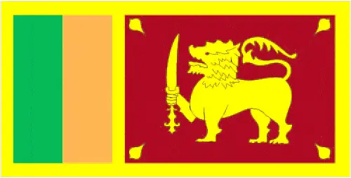 |
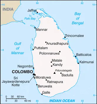
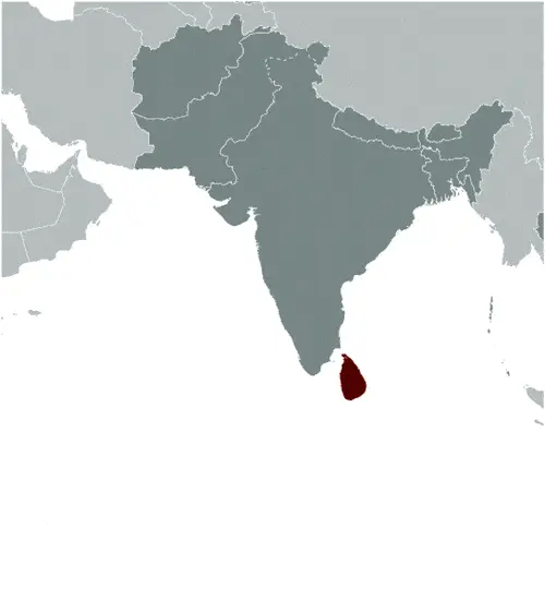
| Borderline map of Sri Lanka | Location map of Sri Lanka | Flag of Sri Lanka |
Google Maps and Detailed Facts of Sri Lanka (CE). This page lets you explore Sri Lanka and its border countries (Country Location: Southern Asia, an island in the Indian Ocean, south of India) through detailed Satellite imagery – fast and easy as never before Google Maps.
Find comprehensive information about this country’s diversity below: Google Maps, geography, economy, science, people, culture, environment, government, and history – All in One Wiki page.
There is also a Street View and free Driving Directions at your service. Your Google Satellite Map Sightseeing in Sri Lanka, in Asia, starts here at Driving Directions and Maps.com.
Sri Lanka Google Maps & Satellite Maps
The map below shows Sri Lanka with its cities, towns, highways, main roads, streets, and Street Views. To find a location, use the form below, type any city or place, view a simple map, and click the “show map” button.
The Google Maps above shows Sri Lanka with its location: Asia (geographic coordinates: 7 00 N, 81 00 E) and the international borders of Sri Lanka; 0 km; furthermore, it’s inland counties boundaries.
Hint: Look at the Street view in Sri Lanka or Asia. All you have to do is drag and pull the little yellow man (named: Pegman) on the Google Maps above the desired location. After that, whenever it is available (more than 50 countries globally), blue stripes will appear to show the photos and details from Google’s regularly updated data image base. In case if you have signed in to your Google account currently, you may have a look at the satellite map of this country/area as well.
The map of Sri Lanka, Asia, is for informational use only. No representation is made or warrantied given any map or its content by Driving Directions and Maps site. The user assumes all risks of using this Sri Lanka Google Maps and facts/wiki.
About Sri Lanka in detail
Where is Sri Lanka?
Sri Lanka is looking on the map under the Coordinates 6 55 N 79 50 E otherwise in Asia, southern Asia, an island in the Indian Ocean, south of India.
What is the capital city of Sri Lanka?
The capital city of Sri Lanka is Colombo.
What is the time in Colombo?
It is 10.5 hours ahead of Washington, D.C. during Standard Time; Colombo’s timezone is UTC+5.5.
What is the Internet code for Sri Lanka?
The Top Level Domain (TLD) for Sri Lanka is: .lk
What is the size of Sri Lanka?
The territory of Sri Lanka is total: 65,610 sq km; land: 64,630 sq km, water: 980 sq km.
If we want to describe the size of the territory of Sri Lanka is slightly larger than West Virginia.
If we would like to walk around and discover Sri Lanka, we can cover 0 km.
What is the water coverage of Sri Lanka?
We have already mentioned what percentage of Sri Lanka is covered by water (see below), including a 1,340 km coastline.
What is the climate like in Sri Lanka?
Sri Lanka’s climate is tropical monsoon: northeast monsoon (December to March): southwest monsoon (June to October).
Geographical data of Sri Lanka
The elevation of Sri Lanka; mean elevation: 228 m, elevation extremes; lowest point: Indian Ocean 0 m, highest point: Pidurutalagala 2,524 m.
The specific geographical details of Sri Lanka include mostly low, flat to rolling plain; mountains in the south-central interior.
Suppose we would like to describe the countries location from a different perspective. In that case, it is safe to say, and easy to read from a map, Sri Lanka is a strategic location near major Indian Ocean sea lanes.
Resources and land use of Sri Lanka
The country’s main mined products are limestone, graphite, mineral sands, gems, phosphates, clay, hydropower, arable land. The population partly uses the earlier highlighted land territory and partly left in its natural state: agricultural land: 43.5%; arable land 20.7%; permanent crops 15.8%; permanent pasture 7%; forest: 29.4%; other: 27.1% (2011 estimate).
Population data of Sri Lanka
The number of inhabitants of Sri Lanka is 22.235 million (July 2016 estimate).
If we examine the proportion of the population distribution, it is safe to say that N/A.
If we look at the proportion of the urbanized and barely populated areas, these are the figures: urban population: 18.4% of the total population (2015).
Most of the population in Sri Lanka is concentrated in Sri Jayewardenepura Kotte (legislative capital) 128,000 (2014); COLOMBO (capital) 707,000 (2015).
Ethnicity in Sri Lanka
According to ethnicity details, the ethnic groups are Sinhalese 74.9%, Sri Lankan Tamil 11.2%, Sri Lankan Moors 9.2%, Indian Tamil 4.2%, other 0.5% (2012 estimate).
The spoken languages in Sri Lanka are the following: Sinhala (official language and national language) 74%, Tamil (official language and national language) 18%, other 8%. Note: English, spoken competently by about 10% of the population, is commonly used in government and is referred to as the link language in the constitution.
What are the most important religions in Sri Lanka?
According to this, during the general census, researchers examine the churches: Buddhist (official) 70.2%, Hindu 12.6%, Muslim 9.7%, Roman Catholic 6.1%, other Christian 1.3%, other 0.05% (2012 estimate).
Further population data of Sri Lanka
The proportion of gender and age tells a lot about the society as follows 0-14 years: 24.35% (male 2,760,821 / female 2,652,747) 15-24 years: 14.7% (male 1,660,402 / female 1,608,022) 25-54 years: 41.71% (male 4,544,253 / female 4,729,544) 55-64 years: 9.89% (male 1,018,357 / female 1,181,060) 65 years and over: 9.35% (male 882,740 / female 1,197,054) (2016 estimate). It also a significant factor in a society the population growth rate, which in the case of Sri Lanka is 0.8% (2016 estimate).
The population growth rate is based on two elements, the birth, and the death rate. In Sri Lanka the birth rate is 15.5 births / 1,000 population (2016 estimate), the death rate 6.2 deaths / 1,000 population (2016 estimate).
In this day and age in developed societies, the first child borns later compared to the previous centuries and decades, so childbearing is extended. In Sri Lanka, the average age of mothers at the first childbirth is N/A.
Although the children’s birth is postponed in the best-case scenario, the parents can still see their kids grow as life expectancy also extended. In the case of Sri Lanka, these figures are. With the introduction of modern medicine, vaccinations, and the proper hygienic conditions, the infant mortality rate is in a steep decline. The infant mortality statistics in Sri Lanka are the following: N/A. Relevant data is the budget of healthcare, which is 3.5% of GDP (2014).
Economic data of Sri Lanka
Suppose we would like to describe a country. We also have to mention its economy; Sri Lanka continues to experience strong economic growth following the government’s 26-year conflict with the Liberation Tigers of Tamil Eelam. The government has been pursuing large-scale reconstruction and development projects in its efforts. The government’s high debt payments and bloated civil service have contributed to historically high budget deficits, and low tax revenues remain a concern. Government debt of about 77% of GDP remains among the highest in emerging markets. The new government in 2015 drastically increased wages for public sector employees, which boosted demand for consumer goods but hurt the overall balance of payments and reduced foreign exchange reserves.
GDP is a prominent figure, as all the relevant calculations and statistics are based on it. GDP in Sri Lanka is $82.24 billion (2015 estimate).
Another important indicator is the rate of GDP growth, which in Sri Lanka is 5% (2016 estimate), 4.8% (2015 estimate) 4.9% (2014 estimate).
These statistics affect the world economy; remember, in 2015, the Chinese real GDP growth rate was worse than expected; The world markets fall, and the Chinese stock exchange is temporally suspended.
A further major factor of a country’s economy, the GDP per capita. In Sri Lanka this is $11,200 (2016 estimate) $10,700 (2015 estimate) $10,300 (2014 estimate).
In the economy, the Trinity is in common places, such as agriculture, industry, and services.
What are the agricultural products Sri Lanka produces?
The main agricultural products of Sri Lanka are rice, sugarcane, grains, pulses, oilseed, spices, vegetables, fruit, tea, rubber, coconuts; milk, eggs, hides, beef; fish.
The important segments are processing rubber, tea, coconuts, tobacco, other agricultural commodities, telecommunications, insurance, banking, tourism, shipping, clothing, textiles, cement, petroleum refining, information technology services, and construction. The crucial and regularly mentioned GDP is based on rubber, tea, coconuts, tobacco, and other agricultural commodities; telecommunications, insurance, banking; tourism, shipping; clothing, textiles; cement, petroleum refining, and information technology services, construction.
Drinking water source in Sri Lanka
It is essential to mention that – thanks to the development of the infrastructure -, the rate of potable water improved: urban: 98.5% of the population, rural: 95% of the people, total: 95.6% of the community. Unimproved: urban: 1.5% of the people, rural: 5% of the people, total: 4.4% of the population (2015 estimate).
The average number of childbirth in Sri Lanka
In Sri Lanka, the average delivery number is 2.09 children born / woman (2016 estimate).
Population, median age, migration, and citizenship in Sri Lanka
The population’s average age is 32.5 years; male: 31.2 years, female: 33.7 years (2016 estimate). The age of adulthood varies in every country of the world. In Sri Lanka, it is 18 years of age, universal.
When we are experiencing an unprecedented scale of migration and globalization, it is an important factor in the number of new immigrants. In Sri Lanka is -1.3 migrant(s) / 1,000 population (2016 estimate). It is important to know how to apply for citizenship: citizenship by birth: no. Citizenship by descent only: at least one parent must be a citizen of Sri Lanka. Dual citizenship recognized: no, except in cases where the government rules it is to the benefit of Sri Lankaresidency requirement for naturalization: 7 years.
Is Sri Lanka a safe destination? Healthcare services and infectious diseases in Sri Lanka
Many of the travelers are looking into the healthcare services and infectious diseases of their destinations. In Sri Lanka, the hospital beds’ density is 3.6 beds / 1,000 population (2012).
According to the WHO rating regarding contagious diseases in Sri Lanka, the degree of risk: high food or waterborne diseases: bacterial diarrhea and hepatitis A vectorborne disease: dengue fever water contact disease: leptospirosis animal contact disease: rabies (2016).
However, HIV is not curable but maintainable. Let’s do not forget when the disease surfaced; it was a world threatening condition. Unfortunately, in some countries, it is still very high the number of infected patients and fatalities due to the disease.
In Sri Lanka, the number of HIV/AIDS deaths: N/A.
Regarding tourism obesity, not an important issue, but we have to mention health statistics, as it is the plague of the 20th and the 21st century. The rate of obese adults in Sri Lanka is 6.8% (2014).
What are the natural hazards in Sri Lanka? Is there any?
The most known natural risk in Sri Lanka is occasional cyclones and tornadoes.
More interesting facts about Sri Lanka
A few words about the past, as every country and society, is connected to its history; The first Sinhalese arrived in Sri Lanka late in the 6th century B.C., probably from northern India. Buddhism was introduced circa 250 B.C., and a great civilization developed at the cities of Anuradhapura (kingdom from circa 200 B.C. to circa A.D. 1000) and Polonnaruwa (from about 1070 to 1200). In the 14th century, a south Indian dynasty established a Tamil kingdom in northern Sri Lanka. The Portuguese controlled the island’s coastal areas in the 16th century and the Dutch in the 17th century. The island was ceded to the British in 1796, became a crown colony in 1802, and was formally united under British rule by 1815. As Ceylon, it became independent in 1948; its name was changed to Sri Lanka in 1972. Tensions between the Sinhalese majority and Tamil separatists erupted into war in 1983.
After two decades of fighting, the government and Liberation Tigers of Tamil Eelam (LTTE) formalized a cease-fire in February 2002 with Norway brokering peace negotiations. Violence between the LTTE and government forces intensified in 2006, but the government regained control of the Eastern Province in 2007, and by May 2009, the remnants of the LTTE had been defeated. Since the end of the conflict, the government has enacted an ambitious program of economic development projects, many of which are financed by loans from China’s Government. In addition to efforts at reconstructing its economy, the government has resettled more than 95% of those civilians displaced during the final phase of the conflict and released the vast majority of former LTTE combatants captured by Government Security Forces. Simultaneously, there has been little progress on more contentious and politically difficult issues, such as reaching a political settlement with Tamil elected representatives and holding accountable those alleged to have been involved in human rights violations and other abuses during the conflict.
In every nation’s memory, some cornerstones placed the country on the timeline of history. The date of declaration of independence of Sri Lanka: 4 February 1948 (from the UK).
The flag and other symbols of Sri Lanka
The colors, symbols, and animals on the flag usually have a historical background or an important milestone or memory of the nation.
This case is not an exception either; yellow with two panels; the smaller hoist-side panel has two equal vertical bands of green (hoist side) and orange; the other larger panel depicts a yellow lion holding a sword on a maroon rectangular field that also displays a yellow bo leaf in each corner; the yellow field appears as a border around the entire flag and extends between the two panels; the lion represents Sinhalese ethnicity, the strength of the nation, and bravery; the sword demonstrates the sovereignty of the nation; the four bo leaves – symbolizing Buddhism and its influence on the country – stand for the four virtues of kindness, friendliness, happiness, and stability; orange signifies Sri Lankan Tamils, green Sri Lankan Moors, and maroon the Sinhalese majority; yellow denotes other ethnic groups; also referred to as the Lion Flag.
Apart from the flag, the symbol of national unity is the national anthem. The anthem’s primary purpose is to share the nation’s core values, endeavors, and patriotic feelings.
National symbols of Sri Lanka: lion, water lily; national colors: maroon, yellow.
Constitution of Sri Lanka
The existence of the nation is based on the constitution. Some constitutions knew worldwide, like the U.S. Constitution that was accepted on the 17th of September 1787, in Philadelphia, the United States of America’s Constitution.
It is not related to the declaration of independence that was stolen by Nicolas Cage in the movie National Treasure 🙂
What is the legal system of Sri Lanka?
Most of the time, the legal system of a country is the focus of lawyers. It is a common fact that there are two main approaches in the world, “the law in books” and “the law in action.”
In the Anglo-Saxon world, the practice is the “law in action,” while in the rest of the world, the law is based on Roman law, the “law in books.”
The legal system of Sri Lanka is a mixed legal system of Roman-Dutch civil law, English common law, and Jaffna Tamil customary law.
It was Aristotle who founded the Theory of 3 separations of powers. In his view, these are the council of public affairs, the magistrates, and the justice system. The age of enlightenment was the time when terminologies have defined the way we still use them. In most democratic countries, the three authorities separated from each other. In dictatorships, the rules usually interweaved in one hand.
About the legislative branch of Sri Lanka, we can highlight the following structures unicameral Parliament (225 seats; 196 members directly elected in multi-seat constituencies by proportional representation vote using a preferential method in which voters select three candidates in order of preference; remaining 29 seats allocated to other political parties and groups in proportion to share of the national vote; members serve 6-year terms).
About the unemployment rate, labor force, and poverty line in Sri Lanka
One of the major problems of the 21st-century economy is unemployment. Governments are struggling to maintain a low level of the unemployment rate. Still, as a result of automation, the cheap 3rd world labor, and the outsourcing of workflow, these attempts fail. In Sri Lanka, the labor force is 9.062 million (2016 estimate). Please bear in mind that the population in Sri Lanka is total: 8.6 deaths / 1,000 live births; male: 9.5 deaths / 1,000 live births, female: 7.6 deaths / 1,000 live births (2016 estimate) – as we already mentioned above.
The rate of unemployment in Sri Lanka is 4.5% (2016 estimate).
Widely known that the gap between the rich and poor is widening on an enormous scale.
According to the 2017 shocking Oxfam report, the most affluent eight people’s fortune is equal to the wealth of the poorest half of the world’s population.
In Sri Lanka, the households’ income and consumption compared to the entire population: lowest 10%: 1.6% highest 10%: 39.5% (2009).
Another widely used indicator is the so-called GINI index, which measures the inequalities of statistical dispersion, but is mainly used for measuring the sharing of income and fortune.
The GINI index was named after its founder Corrado Gini, an Italian economist. Gini index has grades between 0-1, but often it is used on a percentage basis. It is 0 if the examined criteria territorial distribution is equal. It is one of the criteria concentrated on the territory. In Sri Lanka, the GINI index is .49 (2010).
The states usually set up a poverty line, which is more or less, is a subjective measure. It varies by country; its base is often the minimum pension, the incomes of the most deficient 20 percent, the X percent of income per capita Etc.
In Sri Lanka, the poverty line people are the lowest 10%: 1.6% highest 10%: 39.5% (2009).
About the budget and central governments debt of Sri Lanka
The available budget mainly defines the state’s economy. Sri Lanka’s budget is; revenues: $10.98 billion, expenditures: $15.54 billion (2016 estimate). Taxes and other revenues are 13.4% of GDP (2016 estimate).
The budget deficit (Budget surplus (+) or deficit (-)) is N/A.
The fiscal year in Sri Lanka is the calendar year.
In the country’s economy, we have to consider the public debt. Public debt is the consolidated sum of the state’s local, federal, and central government debt.
Inflation rate and prime lending rate in Sri Lanka
A few further interesting and relevant economic data are the following; Inflation rate: 4.3% (2016 estimate), 0.9% (2015 estimate), and the rate of the Commercial bank prime lending rate: 9.8% (31 December 2016 estimate).
Export/import partners and data of Sri Lanka
Sri Lanka, with the export of products, industrial tools, and other services, generates revenue. The export value in Sri Lanka is: $10.12 billion (2016 estimate), $10.5 billion (2015 estimate). These activities’ total revenue: textiles and apparel, tea and spices; rubber manufactures; precious stones; coconut products, fish.
The most critical Sri Lanka export partners are the United States 26%, the United Kingdom 9%, India 7.2%, Germany 4.3% (2015).
The most important imported products are petroleum, textiles, machinery and transportation equipment, building materials, mineral products, foodstuffs, and the countries from where the import is coming: India 24.6%, China 20.6%, United Arab Emirates 7.2%, Singapore 5.9%, Japan 5.7% (2015).
Renewable energies used in Sri Lanka
To suppress the pollution of the environment, renewable energies have to replace the fossil energy. The more the proportion of renewable energies in a country means more effort against pollution. Sri Lanka, the indicator of how much of the country’s produced energy is coming from the hydroelectric source, is 47% of total installed capacity (2012 estimate).
To indicate how much another renewable energy produced is 1.9% of total installed capacity (2012 estimate).
Telecommunication data of Sri Lanka, calling code
To maintain the economy, the development of a reliable and modern telecommunications infrastructure is crucial. We can say the following about Sri Lanka; telephone services have improved significantly and are available in most parts of the country. Domestic: national trunk network consists mostly of digital microwave radio relay; fiber-optic links now in use in Colombo area and fixed wireless local loops have been installed; competition is strong in mobile cellular systems and mobile cellular subscribership. International: country code – 94; the SEA-ME-WE-3 and SEA-ME-WE-4 submarine cables provide connectivity to Asia, Australia, Middle East, Europe, US; satellite earth stations – 2 Intelsat (Indian Ocean) (2015).
Transport infrastructure in Sri Lanka
In the 21st century, we often say that the world has become small and there are no distances anymore. With widespread air travel when (sometimes) there are no visa restrictions, it is easy to reach other countries, but if the distance is not too long, we can also use railway or water transportation.
The number of airports in Sri Lanka: 19 (2013), and the number of heliports: 1 (2013).
The total length of the roadways in Sri Lanka: total: 114,093 km, paved: 16,977 km, unpaved: 97,116 km (2010).
The waterways’ total length in Sri Lanka: 160 km (primarily on rivers in the southwest) (2012).
Are you traveling to Sri Lanka?
If you plan to travel by plane to Sri Lanka, try our air ticket comparison site, where you can choose from hundreds of carriers and offers. Our application is scanning the market and shows you the best and the cheapest deals without any extra charge or commission.
Are you looking for a hotel, apartment another kind of accommodation in Sri Lanka, Asia? We are here to help you to find your accommodation from budget to luxury. Our search engine is scanning, regularly updating data from hundreds of accommodation websites and more than a million offers. You can quickly and easily find your hotel stay anywhere in the world, without any extra charge or commission.
Facts & data about Sri Lanka
Name of the country: conventional long way: the Democratic Socialist Republic of Sri Lanka, traditional short form: Sri Lanka, local long form: Shri Lanka Prajatantrika Samajavadi Janarajaya/Ilankai Jananayaka Choshalichak Kutiyarachu, local short state: Shri Lanka/Ilankai, former: Serendib, Ceylon. Note: the name means “resplendent island” in Sanskrit.
| Abbreviation: Sri Lanka | Geographic coordinates: 7 00 N, 81 00 E |
Country Location: Asia |
| Capital of Sri Lanka: Colombo | GPS of the Capital: 6 55 N 79 50 E |
Position: Southern Asia, an island in the Indian Ocean, south of India |
| Land area: total: 65,610 sq km; land: 64,630 sq km, water: 980 sq km | Terrain: mostly low, flat to rolling plain; mountains in south-central interior |
Area comparative: slightly larger than West Virginia |
| Population: 22.235 million (July 2016 estimate) | Population grow rate: 0.8% (2016 estimate) | Sex ratio: at birth: 1.04 male(s) / female, 0-14 years: 1.04 male(s) / female, 15-24 years: 1.03 male(s) / female, 25-54 years: 0.96 male(s) / female, 55-64 years: 0.86 male(s) / female, 65 years and over: 0.74 male(s) / female, total population: 0.96 male(s) / female (2016 estimate) |
| Exports: $10.12 billion (2016 estimate), $10.5 billion (2015 estimate) | Imports: $18.64 billion (2016 estimate), $18.93 billion (2015 estimate) | Import partners: India 24.6%, China 20.6%, UAE 7.2%, Singapore 5.9%, Japan 5.7% (2015) |
| Urbanization: urban population: 18.4% of the total population (2015) | Major urban area(s): Sri Jayewardenepura Kotte (legislative capital) 128,000 (2014); COLOMBO (capital) 707,000 (2015) | Median age: total: 32.5 years; male: 31.2 years, female: 33.7 years (2016 estimate) |
| Internet users: total: 6.614 million. Percent of the population: 30% (July 2015 estimate) | Telephones (fixed-lines): total subscriptions: 2,601,196. Subscriptions per 100 inhabitants: 12 (July 2015 estimate) | Telephones (mobile, cellular): total: 24.385 million. Subscriptions per 100 inhabitants: 111 (July 2015 estimate) |
| Unemployment rate: 4.5% (2016 estimate) | Nationality: Sri Lankan(s) adjective: Sri Lankan | National holidays: Independence Day, 4 February (1948) |
| Life expectancy at birth: total population: 76.8 years. Male: 73.3 years, female: 80.4 years (2016 estimate) | Total fertility rate: 2.09 children born / woman (2016 estimate) | Birthrate: 15.5 births / 1,000 population (2016 estimate) |
| Literacy: age 15 and over can read and write. Total population: 92.6%; male: 93.6%, female: 91.7% (2015 estimate) | Legal system: mixed legal system of Roman-Dutch civil law, English common law, and Jaffna Tamil customary law | Suffrage: 18 years of age, universal |
| Industries: processing of rubber, tea, coconuts, tobacco and other agricultural commodities; telecommunications, insurance, banking; tourism, shipping; clothing, textiles; cement, petroleum refining, information technology services, construction | Industrial production growth rate: 5.6% (2016 estimate) | GDP real growth rate: 5% (2016 estimate) 4.8% (2015 estimate) 4.9% (2014 estimate) |
Do you like this Sri Lanka Google Maps & country information page?
Please do us a favor: Share or like this page using the icons at the top of the page. We also do encourage you to visit our Facebook page for more travel and country related information.
Many thanks for visiting and sharing this map & country information site!