
 |
 |
 |
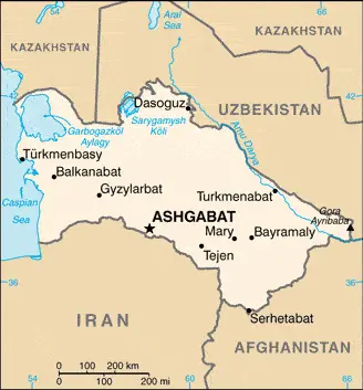
| Borderline map of Turkmenistan | Location map of Turkmenistan | Flag of Turkmenistan |
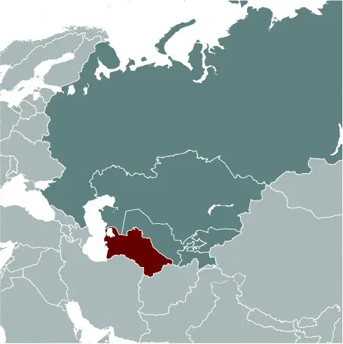
Google Maps and Detailed Facts of Turkmenistan (TM). This page lets you explore Turkmenistan and its border countries (Country Location: Central Asia, bordering the Caspian Sea, between Iran and Kazakhstan) through detailed Satellite imagery – fast and easy as never before Google Maps.
Find comprehensive information about this country’s diversity below: Google Maps, geography, economy, science, people, culture, environment, government, and history – All in One Wiki page.
There is also a Street View and free Driving Directions at your service. Your Google Satellite Map Sightseeing in Turkmenistan, in Asia, starts here at Driving Directions and Maps.com.
Turkmenistan Google Maps & Satellite Maps
The map below shows Turkmenistan with its cities, towns, highways, main roads, streets, and Street Views. To find a location, use the form below, type any city or place, view a simple map, and click the “show map” button.
The Google Maps above shows Turkmenistan with its location: Asia (geographic coordinates: 40 00 N, 60 00 E) and the international borders of Turkmenistan; total: 4,158 km. Border countries (total: 4): Afghanistan 804 km, Iran 1,148 km, Kazakhstan 413 km, Uzbekistan 1,793 km; furthermore, it’s inland counties boundaries.
Hint: Look at the Street view in Turkmenistan or Asia. All you have to do is drag and pull the little yellow man (named: Pegman) on the Google Maps above the desired location. After that, whenever it is available (more than 50 countries globally), blue stripes will appear to show the photos and details from Google’s regularly updated data image base. In case if you have signed in to your Google account currently, you may have a look at the satellite map of this country/area as well.
The map of Turkmenistan, Asia, is for informational use only. No representation is made or warrantied given any map or its content by Driving Directions and Maps site. The user assumes all risks of using this Turkmenistan Google Maps and facts/wiki.
About Turkmenistan in detail
Where is Turkmenistan?
In case Turkmenistan is looking on the map under the Coordinates 37 57 N 58 23 E otherwise in Asia, in Central Asia, bordering the Caspian Sea, between Iran and Kazakhstan.
What is the capital city of Turkmenistan?
The capital city of Turkmenistan is Ashgabat.
What is the time in Ashgabat?
It is 10 hours ahead of Washington, D.C. during Standard Time; the timezone of Ashgabat is UTC+5.
What is the Internet code for Turkmenistan?
The Top Level Domain (TLD) for Turkmenistan is: .tm
What is the size of Turkmenistan?
The territory of Turkmenistan is total: 488,100 sq km; land: 469,930 sq km, water: 18,170 sq km.
If we want to describe the size of the territory of Turkmenistan is slightly larger than California.
If we would like to walk around and discover Turkmenistan, we can cover a total distance: 4,158 km.
What is the water coverage of Turkmenistan?
We have already mentioned what percentage of Turkmenistan is covered by water (see below), and this includes 0 km; note – Turkmenistan borders the Caspian Sea (1,768 km) coastline.
What is the climate like in Turkmenistan?
The climate of Turkmenistan is a subtropical desert.
Geographical data of Turkmenistan
The elevation of Turkmenistan; mean elevation: 230 m, elevation extremes; lowest point: Vpadina Akchanaya -81 m, highest point: Gora Ayribaba 3,139 m.
The specific geographical details of Turkmenistan include flat-to-rolling sandy desert with dunes rising to mountains in the south; low mountains along the border with Iran; borders the Caspian Sea in the west.
Suppose we would like to describe the countries location from a different perspective. In that case, it is safe to say, and easy to read from a map, Turkmenistan is a landlocked country; the western and central low-lying desolate portions of the country make up the great Garagum (Kara-Kum) desert, which occupies over 80% of the country; the eastern part is a plateau.
Resources and land use of Turkmenistan
The country’s main mined products are petroleum, natural gas, sulfur, salt. The population partly uses the earlier highlighted land territory and partly left in its natural state: agricultural land: 72%; arable land 4.1%; permanent crops 0.1%; permanent pasture 67.8%; forest: 8.8%; other: 19.2% (2011 estimate).
Population data of Turkmenistan
The number of inhabitants of Turkmenistan is 5,291,317 (July 2016 estimate).
If we examine the proportion of the population distribution, it is safe to say that the most densely populated areas are the southern, eastern, and northeastern oases; approximately 50% of the population lives in and around the capital Ashgabat.
If we look at the proportion of the urbanized and barely populated areas, these are the figures: urban population: 50% of the total population (2015).
Most of the population in Turkmenistan is concentrated in ASHGABAT (capital) 746,000 (2015).
Ethnicity in Turkmenistan
According to ethnicity details, the ethnic groups are Turkmen 85%, Uzbek 5%, Russian 4%, other 6% (2003).
Spoken languages in Turkmenistan
The spoken languages in Turkmenistan are the following: Turkmen (official language) 72%, Russian 12%, Uzbek 9%, other 7%.
What are the most important religions in Turkmenistan?
According to this, during the general census, researchers examine the churches: Muslim 89%, Eastern Orthodox 9%, unknown 2%.
Further population data of Turkmenistan
The proportion of gender and age tells a lot about the society as follows 0-14 years: 25.95% (male 695,752 / female 677,166) 15-24 years: 19.04% (male 506,856 / female 500,647) 25-54 years: 42.86% (male 1,125,058 / female 1,142,870) 55-64 years: 7.59% (male 189,464 / female 212,330) 65 years and over: 4.56% (male 105,140 / female 136,034) (2016 estimate). It also a significant factor in a society the population growth rate, which in the case of Turkmenistan is 1.13% (2016 estimate).
The population growth rate is based on two elements, the birth, and the death rate. In Turkmenistan the birth rate is 19.3 births / 1,000 population (2016 estimate), the death rate 6.1 deaths / 1,000 population (2016 estimate).
In this day and age in developed societies, the first child borns later compared to the previous centuries and decades, so childbearing is extended. In Turkmenistan, the average age of mothers at the first childbirth is N/A.
Although the children’s birth is postponed in the best-case scenario, the parents can still see their kids grow as life expectancy also extended. In the case of Turkmenistan, these figures are. With the introduction of modern medicine, vaccinations, and the proper hygienic conditions, the infant mortality rate is in a steep decline. The infant mortality statistics in Turkmenistan are the following: N/A. Relevant data is the budget of healthcare, which is in this country’s case is 2.1% of GDP (2014).
Economic data of Turkmenistan
Suppose we would like to describe a country. We also have to mention its economy; Turkmenistan is mostly a desert country with intensive agriculture in irrigated oases and significant natural gas and oil resources. The two largest crops are cotton, mostly produced for export, and wheat, which is domestically consumed. AlthouTurkmenistan’s autocratic governments under presidents NIYAZOW (1991-2006) and BERDIMUHAMEDOW (since 2007) have made little progress improving the business climate, privatizing state-owned industries, and combatting corruption, limiting economic development. Low energy prices since mid-2014 are hampering Turkmenistan’s economic growth and reducing government revenues. The government has cut subsidies in several areas, and wage arrears have increased. In January 2014, the Central Bank of Turkmenistan devalued.
GDP is a prominent figure, as all the relevant calculations and statistics are based on it. GDP in Turkmenistan is $36.57 billion (2015 estimate).
Another important indicator is the rate of GDP growth, which in Turkmenistan is 5.4% (2016 estimate), 6.5% (2015 estimate) 10.3% (2014 estimate).
These statistics affect the world economy; remember, in 2015, the Chinese real GDP growth rate was worse than expected; The world markets fall, and the Chinese stock exchange was temporarily suspended.
A further major factor of a country’s economy, the GDP per capita. In Turkmenistan this is $17,300 (2016 estimate) $16,700 (2015 estimate) $15,900 (2014 estimate).
In the economy, the Trinity is in common places, such as agriculture, industry, and services.
What are the agricultural products Turkmenistan produces?
The main agricultural products of Turkmenistan are cotton, grain, melons, livestock.
The essential segments are natural gas, oil, petroleum products, textiles, and food processing. The crucial and regularly mentioned GDP is based on natural gas, oil, petroleum products, materials, food processing.
Drinking water source in Turkmenistan
It is essential to mention that – thanks to the development of the infrastructure -, the rate of potable water improved: urban: 89.1% of the population, rural: 53.7% of the population, total: 71.1% of the population. Unimproved: urban: 10.9% of the people, rural: 46.3% of the population, total: 28.9% of the population (2012 estimate).
The average number of childbirth in Turkmenistan
In Turkmenistan, the average delivery number is 2.08 children born / woman (2016 estimate).
Population, median age, migration, and citizenship in Turkmenistan
The population’s average age is 27.5 years; male: 27 years, female: 28 years (2016 estimate). The age of adulthood varies in every country of the world in Turkmenistan; it is 18 years of age, universal.
When we are experiencing an unprecedented scale of migration and globalization, it is an important factor in the number of new immigrants. In Turkmenistan is -1.8 migrant(s) / 1,000 population (2016 estimate). It is important to know how to apply for citizenship: citizenship by birth: no. Citizenship by descent only: at least one parent must be a citizen of Turkmenistan. Dual citizenship recognized: yes, the residency requirement for naturalization: 7 years.
Is Turkmenistan a safe destination? Healthcare services and infectious diseases in Turkmenistan
Many of the travelers are looking into the healthcare services and infectious diseases of their destinations. In Turkmenistan, the hospital beds’ density is four beds / 1,000 population (2012).
According to the WHO rating regarding contagious diseases in Turkmenistan: N/A.
However, HIV is not curable but maintainable. Let’s do not forget when the disease surfaced; it was a world threatening condition. Unfortunately, in some countries, it is still very high the number of infected patients and fatalities due to the disease.
In Turkmenistan, the number of HIV/AIDS deaths: N/A.
Regarding tourism obesity, not an important issue, but we have to mention health statistics, as it is the plague of the 20th and the 21st century. The rate of obese adults in Turkmenistan is 18.8% (2014).
What are the natural hazards in Turkmenistan? Is there any?
The most known natural risk in Turkmenistan is N/A.
More interesting facts about Turkmenistan
A few words about the past, as every country and society, is connected to its history; Present-day Turkmenistan covers territory that has been at the crossroads of civilizations for centuries. The area was ruled in antiquity by various Persian empires and was conquered by Alexander the Great, Muslim armies, the Mongols, Turkic warriors, and eventually the Russians. In medieval times, Merv (located in present-day Mary province) was one of the great cities of the Islamic world and an important stop on the Silk Road. Annexed by Russia in the late 1800s, Turkmenistan later figured prominently in the anti-Bolshevik movement in Central Asia. In 1924, Turkmenistan became a Soviet republic; it achieved independence upon the USSR’s dissolution in 1991. Extensive hydrocarbon/natural gas reserves, which have yet to be fully exploited, have transformed the country.
The Government of Turkmenistan is moving to expand its extraction and delivery projects and has attempted to diversify its gas export routes beyond Russia’s pipeline network. In 2010, new gas export pipelines that carry Turkmen gas to China and northern Iran began operating, effectively ending the Russian monopoly on Turkmen gas exports. Subsequently, decreased Russian purchases and limited purchases by Iran have made China the dominant buyer of Turkmen gas. President for Life Saparmurat NYYAZOW died in December 2006, and Turkmenistan held its first multi-candidate presidential election in February 2007. Gurbanguly BERDIMUHAMEDOW, a deputy cabinet chairman under NYYAZOW emerged as the country’s new president; he was re-elected in February 2012 with 97% of the vote, in an election widely regarded as undemocratic.
In every nation’s memory, some cornerstones placed the country on the timeline of history. The date of declaration of independence of Turkmenistan: 27 October 1991 (from the Soviet Union).
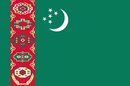
The flag and other symbols of Turkmenistan
The colors, symbols, and animals on the flag usually have a historical background or an important milestone or memory of the nation.
This case is not an exception either; green field with a vertical red stripe near the hoist side, containing five tribal guls (designs used in producing carpets) stacked above two crossed olive branches; five white stars and a white crescent moon appear in the upper corner of the field just to the fly side of the red stripe; the green color and crescent moon represent Islam; the five stars symbolize the regions or welayats of Turkmenistan; the guls reflect the national identity of Turkmenistan where carpet-making has long been a part of traditional nomadic life. Note: the flag of Turkmenistan is the most intricate of all national flags.
Apart from the flag, the symbol of national unity is the national anthem. The anthem’s primary purpose is to share the nation’s core values, endeavors, and patriotic feelings.
National symbols of Turkmenistan: Akhal-Teke horse; national colors: green, white.
Constitution of Turkmenistan
The existence of the nation is based on the constitution. Some constitutions knew worldwide, like the U.S. Constitution that was accepted on the 17th of September 1787, in Philadelphia, the United States of America’s Constitution.
It is not related to the declaration of independence that was stolen by Nicolas Cage in the movie National Treasure 🙂
What is the legal system of Turkmenistan?
Most of the time, the legal system of a country is the focus of lawyers. It is a common fact that there are two main approaches in the world, “the law in books” and “the law in action.”
In the Anglo-Saxon world, the practice is the “law in action,” while in the rest of the world, the law is based on Roman law, the “law in books.”
The legal system of Turkmenistan is a civil law system with Islamic law influences.
It was Aristotle who founded the Theory of 3 separations of powers. In his view, these are the council of public affairs, the magistrates, and the justice system. The age of enlightenment was the time when terminologies have defined the way we still use them. In most democratic countries, the three authorities separated from each other. In dictatorships, the rules usually interweaved in one hand.
About the legislative branch of Turkmenistan, we can highlight the following structures unicameral National Assembly or Mejlis (125 seats; members directly elected from districts having about the same number of voters; members serve 5-year terms); note – in September 2008, a constitutional change abolished a second, 2,507-member People’s Council and expanded the membership in the National Assembly to 125 from 65; the powers formerly held by the People’s Council were divided between the president and the National Assembly.
About the unemployment rate, labor force, and poverty line in Turkmenistan
One of the major problems of the 21st-century economy is unemployment. Governments are struggling to maintain a low level of the unemployment rate. Still, as a result of automation, the cheap 3rd world labor, and the outsourcing of workflow, these attempts fail. In Turkmenistan, the labor force is 2.305 million (2013 estimate). Please bear in mind that the population in Turkmenistan is total: 35.5 deaths / 1,000 live births; male: 42.7 deaths / 1,000 live births, female: 28.1 deaths / 1,000 live births (2016 estimate) – as we already mentioned above.
The rate of unemployment in Turkmenistan is 11% (2014 estimate).
Widely known that the gap between the rich and poor is widening on an enormous scale.
According to the 2017 shocking Oxfam report, the most affluent eight people’s fortune is equal to the wealth of the poorest half of the world’s population.
In Turkmenistan, the households’ income and consumption compared to the entire population: lowest 10%: 2.6% highest 10%: 31.7% (1998).
Another widely used indicator is the so-called GINI index, which measures the inequalities of statistical dispersion, but is mainly used for measuring the sharing of income and fortune.
The GINI index was named after its founder Corrado Gini, an Italian economist. Gini index has grades between 0-1, but often it is used on a percentage basis. It is 0 if the examined criteria territorial distribution is equal. It is one of the criteria concentrated on the territory. In Turkmenistan, the GINI index is .40,8 (1998).
The states usually set up a poverty line, which is more or less, is a subjective measure. It varies by country; its base is often the minimum pension, the incomes of the most deficient 20 percent, the X percent of income per capita Etc.
In Turkmenistan, the poverty line people are the lowest 10%: 2.6% highest 10%: 31.7% (1998).
About the budget and central governments debt of Turkmenistan
The available budget mainly defines the state’s economy. The budget of Turkmenistan is; revenues: $3.765 billion, expenditures: $4.753 billion (2016 estimate). Taxes and other revenues are 10.3% of GDP (2016 estimate).
The budget deficit (Budget surplus (+) or deficit (-)) is N/A.
The fiscal year in Turkmenistan is the calendar year.
In the country’s economy, we have to consider the public debt. Public debt is the consolidated sum of the state’s local, federal, and central government debt.
Inflation rate and prime lending rate in Turkmenistan
A few further interesting and relevant economic data are the following; Inflation rate: 11% (2016 estimate), 16% (2015 estimate), and the commercial bank prime lending rate: N/A.
Export/import partners and data of Turkmenistan
Turkmenistan, with the export of products, industrial tools, and other services, generates revenue. The export value in Turkmenistan is $8.756 billion (2016 estimate), $10.38 billion (2015 estimate). The total revenue of these activities: gas, crude oil, petrochemicals, textiles, cotton fiber.
The most important export partners of Turkmenistan are China, 68.6%, Turkey, 4.9% (2015).
The most important imported products are machinery and equipment, chemicals, foodstuffs, and the countries from where the import is coming: Turkey 24.9%, Russia 12.3%, China 10.9%, UAE 9.1%, Kazakhstan 5.1%, Germany 4.6%, Iran 4.4% (2015).
Renewable energies used in Turkmenistan
To suppress the pollution of the environment, renewable energies have to replace the fossil energy. The more the proportion of renewable energies in a country means more effort against pollution. Turkmenistan, the indicator of how much of the country’s produced energy is coming from the hydroelectric source, is 0% of total installed capacity (2014 estimate).
To indicate how much another renewable energy produced is 0% of total installed capacity (2014 estimate).
Telecommunication data of Turkmenistan, calling code
To maintain the economy, the development of a reliable and modern telecommunications infrastructure is crucial. We can say the following about Turkmenistan; the telecommunications network is gradually improving. Domestic: Turkmentelekom, in cooperation with foreign partners, has installed high-speed fiber-optic lines and has upgraded most of its telephone exchanges and switching centers with new digital technology, combined fixed-line, and mobile teledensity. International: country code – 993; linked by fiber-optic cable and microwave radio relay to other CIS republics and other countries by leased connections to the Moscow international gateway switch; an exchange in Ashgabat switches international traffic through Turkey (2015).
Transport infrastructure in Turkmenistan
In the 21st century, we often say that the world has become small and there are no distances anymore. With widespread air travel when (sometimes) there are no visa restrictions, it is easy to reach other countries, but if the distance is not too long, we can also use railway or water transportation.
The number of airports in Turkmenistan: 26 (2013), and the number of heliports: 1 (2013).
The total length of the roadways in Turkmenistan: 58,592 km, paved: 47,577 km, unpaved: 11,015 km (2002).
The total length of the waterways in Turkmenistan: 1,300 km (the Amu Darya and Kara Kum canal are important inland waterways) (2011).
Are you traveling to Turkmenistan?
If you plan to travel by plane to Turkmenistan, try our air ticket comparison site, where you can choose from hundreds of carriers and offers. Our application is scanning the market and shows you the best and the cheapest deals without any extra charge or commission.
Are you looking for a hotel, apartment another kind of accommodation in Turkmenistan, Asia? We are here to help you to find your accommodation from budget to luxury. Our search engine is scanning, regularly updating data from hundreds of accommodation websites and more than a million offers. You can quickly and easily find your hotel stay anywhere in the world, without any extra charge or commission.
Facts & data about Turkmenistan
Name of the country: conventional long way: none, traditional short form: Turkmenistan, local long form: none, local short state: Turkmenistan, former: Turkmen Soviet Socialist Republic, etymology: the suffix “-stan” means “place of” or “country,” so Turkmenistan literally means the “Land of the Turkmen [people].”
| Abbreviation: Turkmenistan | Geographic coordinates: 40 00 N, 60 00 E |
Country Location: Asia |
| Capital of Turkmenistan: Ashgabat | GPS of the Capital: 37 57 N 58 23 E |
Position: Central Asia, bordering the Caspian Sea, between Iran and Kazakhstan |
| Land area: total: 488,100 sq km; land: 469,930 sq km, water: 18,170 sq km | Terrain: flat-to-rolling sandy desert with dunes rising to mountains in the south; low mountains along border with Iran; borders Caspian Sea in west |
Area comparative: slightly larger than California |
| Population: 5,291,317 (July 2016 estimate) | Population grow rate: 1.13% (2016 estimate) | Sex ratio: at birth: 1.05 male(s) / female, 0-14 years: 1.03 male(s) / female, 15-24 years: 1.01 male(s) / female, 25-54 years: 0.98 male(s) / female, 55-64 years: 0.89 male(s) / female, 65 years and over: 0.77 male(s) / female, total population: 0.98 male(s) / female (2016 estimate) |
| Exports: $8.756 billion (2016 estimate), $10.38 billion (2015 estimate) | Imports: $7.467 billion (2016 estimate), $8.198 billion (2015 estimate) | Import partners: Turkey 24.9%, Russia 12.3%, China 10.9%, UAE 9.1%, Kazakhstan 5.1%, Germany 4.6%, Iran 4.4% (2015) |
| Urbanization: urban population: 50% of the total population (2015) | Major urban area(s): ASHGABAT (capital) 746,000 (2015) | Median age: total: 27.5 years; male: 27 years, female: 28 years (2016 estimate) |
| Internet users: total: 785,000. Percent of the population: 15% (July 2015 estimate) | Telephones (fixed-lines): total subscriptions: 648,000. Subscriptions per 100 inhabitants: 12 (July 2015 estimate) | Telephones (mobile, cellular): total: 7.842 million. Subscriptions per 100 inhabitants: 150 (July 2015 estimate) |
| Unemployment rate: 11% (2014 estimate) | Nationality: Turkmen(s) adjective: Turkmen | National holidays: Independence Day, 27 October (1991) |
| Life expectancy at birth: total population: 70.1 years. Male: 67.1 years, female: 73.3 years (2016 estimate) | Total fertility rate: 2.08 children born / woman (2016 estimate) | Birthrate: 19.3 births / 1,000 population (2016 estimate) |
| Literacy: age 15 and over can read and write. Total population: 99.7%; male: 99.8%, female: 99.6% (2015 estimate) | Legal system: civil law system with Islamic law influences | Suffrage: 18 years of age, universal |
| Industries: natural gas, oil, petroleum products, textiles, food processing | Industrial production growth rate: 1% (2016 estimate) | GDP real growth rate: 5.4% (2016 estimate) 6.5% (2015 estimate) 10.3% (2014 estimate) |
Do you like this Turkmenistan Google Maps & country information page?
Please do us a favor: Share or like this page using the icons at the top of the page. We also do encourage you to visit our Facebook page for more travel and country related information.
Many thanks for visiting and sharing this map & country information site!