
Bujumbura is one of the most populated cities in Burundi, and at the same time, this city is the capital of this country. Located in Africa, you may find the city easily with the following GPS coordinates: 03.16S latitude / 29.18E longitude. For routing in Bujumbura, please check the free driving directions Bujumbura service below.
Africa maps
Explore the countries in Africa with all their Wiki, find information on weather, population, facts, history, landmarks of major cities data, and enjoy free Google maps Satellite imagery & Street views. Each Country Profile in Africa provides information on Geography data, area maps, Google maps, flag, history, area, population, the capital city, largest cities, economy, spoken languages, ethnicity/race, religion, literacy rate, government, and many more!
In this map category, you will find these African countries and their capital cities:
Algeria, Angola, Benin, Botswana, Burkina Faso, Burundi, Cameroon, Cape Verde, Chad, Comoros, Democratic Republic of the Congo, Republic of Congo, Côte d’Ivoire, Djibouti, Egypt, Equatorial Guinea, Eritrea, Ethiopia, Gabon, Gambia, Ghana, Guinea, Guinea-Bissau, Guyana, Kenya, Lesotho, Liberia, Libya, Madagascar, Malawi, Mali, Mauritania, Mauritius, Morocco, Mozambique, Namibia, Niger, Nigeria, Rwanda, São Tomé and Príncipe, Senegal, Seychelles, Sierra Leone, Somalia, South Africa, Sudan, Swaziland, Tanzania, Togo, Tunisia, Uganda, Zambia, Zimbabwe.
Google Maps™ driving directions home » Africa maps
Burkina Faso
Driving Directions Burkina Faso
BURKINA FASO is a landlocked country in West Africa. The People’s Democratic Republic of Burkina Faso was formerly called Upper Volta and is one of the world’s poorest countries. It comprises a plateau region in the north on the Sahara fringe, which gives way southwards to an area of plains. The northern part of the country is arid and is an extension of the Sahara Desert. The south is less dry and has savannah-type vegetation and scattered trees, although desertification threatens part of this land.
Google Maps™ driving directions home » Africa maps

Burkina Faso Google Map
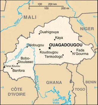
Google Maps and Detailed Facts of Burkina Faso (BF). This page lets you explore Burkina Faso and its border countries (Country Location: Western Africa, north of Ghana) through detailed Satellite imagery – fast and easy as never before Google Maps.
Find comprehensive information about this country’s diversity below: Google maps, geography, economy, science, people, culture, environment, government, and history – All in One Wiki page.
There is also a Street View and free Driving Directions at your service. Your Google Satellite Map Sightseeing in Burkina Faso, Africa, starts here at Driving Directions and Maps.com.
Google Maps™ driving directions home » Africa maps
Burundi
Driving Directions Burundi
BURUNDI is a small, densely populated republic in central east Africa bounded by Rwanda to the north, Tanzania to the east and south, and the Democratic Republic of Congo to the west. One of the world’s poorest nations, Burundi consists mainly of an upland plateau at an elevation of around 1,400-1,800 meters or 4,600-5,900 feet. In the west, the land falls away to the River Rusizi and Lake Tanganyika valley, lying within the African Rift Valley. The plateau also drops away eastwards and southeastwards towards the valleys of the Ruyuvu and Malagarasi rivers.
Google Maps™ driving directions home » Africa maps

Burundi Google Map
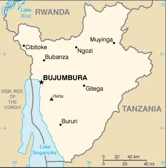
Google Maps and Detailed Facts of Burundi (BY). This page lets you explore Burundi and its border countries (Country Location: Central Africa, east of the Democratic Republic of the Congo, west of Tanzania) through detailed Satellite imagery – fast and easy as never before Google Maps.
Find comprehensive information about this country’s diversity below: Google maps, geography, economy, science, people, culture, environment, government, and history – All in One Wiki page.
There is also a Street View and free Driving Directions at your service. Your Google Satellite Map Sightseeing in Burundi, Africa, starts here at Driving Directions and Maps.com.
Google Maps™ driving directions home » Africa maps

Cabo Verde Google Map
Google Maps and Detailed Facts of Cabo Verde (CV). This page lets you explore Cabo Verde and its border countries (Country Location: Western Africa, group of islands in the North Atlantic Ocean, west of Senegal) through detailed Satellite imagery – fast and easy as never before Google Maps.
Find comprehensive information about this country’s diversity below: Google maps, geography, economy, science, people, culture, environment, government, and history – All in One Wiki page.
There is also a Street View and free Driving Directions at your service. Your Google Satellite Map Sightseeing in Cabo Verde starts at Driving Directions and Maps.com in Africa.
Google Maps™ driving directions home » Africa maps
Cairo Google maps
Cairo is one of the most populated cities in Egypt, and at the same time, this city is the capital of this country. Located in Africa, you may find the city easily with the following GPS coordinates: 30.01N latitude / 31.14E longitude. For routing in Cairo, please check the free driving directions Cairo service below.
Google Maps™ driving directions home » Africa maps
Cameroon
Driving Directions Cameroon
CAMEROON is a triangular-shaped republic of diverse landscapes in west-central Africa. It stretches from Lake Chad at its apex to the northern borders of Equatorial Guinea, Gabon, and the Congo in the south. Cameroon is a country of varied topography and natural vegetation. The far north is a region of savannah plain with marshland near the shores of Lake Chad. Eastwards, the land becomes drier, grading towards the Sahel grasslands in Chad. In the west, a belt of volcanic mountains and bamboo forests spill over the border with Nigeria. Further south, the savannah plains rise gradually to form the extensive Adamawa Plateau (Massif de I’Adoumaoua), partly covered in woodland. In the south, the coastal plain is covered with tropical rainforests. In the West, out of this rises a group of high volcanic mountains, including the sporadically active Mount Cameroon (4,100 meters or 1,250 feet).
Google Maps™ driving directions home » Africa maps
Cameroon Google Map
Google Maps and Detailed Facts of Cameroon (CM). This page lets you explore Cameroon and its border countries (Country Location: Central Africa, bordering the Bight of Biafra, between Equatorial Guinea and Nigeria) through detailed Satellite imagery – fast and easy as never before Google Maps.
Find comprehensive information about this country’s diversity below: Google maps, geography, economy, science, people, culture, environment, government, and history – All in One Wiki page.
There is also a Street View and free Driving Directions at your service. Your Google Satellite Map Sightseeing in Cameroon, in Africa, starts here at Driving Directions and Maps.com.
Google Maps™ driving directions home » Africa maps
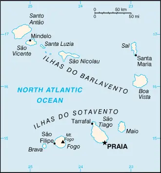
Cape Verde
Driving Directions Cape Verde
CAPE VERDE, one of the world’s smallest nations, is situated in the Atlantic Ocean, about 640 kilometers or 400 miles northwest of Senegal. It consists of ten islands and five islets, and there is an active volcano on Fogo, one of the islands. The islands are divided into the Windward group and the Leeward group.