Google Maps™ driving directions home » Africa maps

Niger

Driving Directions Niger

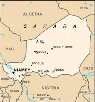
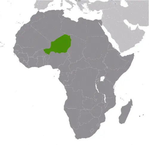
NIGER is a landlocked republic in West Africa, just south of the Tropic of Cancer. Over half of the country is covered by the encroaching Sahara Desert in the north, while the drought-stricken Sahel grasslands lie to the south. In the extreme southwest corner, the River Niger, an essential navigable waterway, flows southeastwards for 483 kilometers or 300 miles, cutting off Niger’s far western territory.

Read more

Google Maps™ driving directions home » Africa maps

Niger Google Map

This image shows the draft map of Niger, Africa. For more details of the map of Niger, please see this page below. This image shows the location of Niger, Africa. For more geographical details of Niger, please see this page below. This image shows the flag of Niger, Africa. For more details of the flag of Niger, please see this page below.
Borderline map of Niger Location map of Niger Flag of Niger

Niger Google map

Google Maps and Detailed Facts of Niger (NE). This page lets you explore Niger and its border countries (Country Location: Western Africa, southeast of Algeria) through detailed Satellite imagery – fast and easy as never before Google Maps.

Find comprehensive information about this country’s diversity below: Google maps, geography, economy, science, people, culture, environment, government, and history – All in One Wiki page.

There is also a Street View and free Driving Directions at your service. Your Google Satellite Map Sightseeing in Niger, in Africa, starts here at Driving Directions and Maps.com.

Read more

Google Maps™ driving directions home » Africa maps

Nigeria Google Map

This image shows the draft map of Nigeria, Africa. For more details of the map of Nigeria, please see this page below. This image shows the location of Nigeria, Africa. For more geographical details of Nigeria, please see this page below. This image shows the flag of Nigeria, Africa. For more details of the flag of Nigeria, please see this page below.
Borderline map of Nigeria Location map of Nigeria Flag of Nigeria

Nigeria Google map

Google Maps and Detailed Facts of Nigeria (NG). This page lets you explore Nigeria and its border countries (Country Location: Western Africa, bordering the Gulf of Guinea, between Benin and Cameroon) through detailed Satellite imagery – fast and easy as never before Google Maps.

Find comprehensive information about this country’s diversity below: Google maps, geography, economy, science, people, culture, environment, government, and history – All in One Wiki page.

There is also a Street View and free Driving Directions at your service. Your Google Satellite Map Sightseeing in Nigeria, in Africa, starts here at Driving Directions and Maps.com.

Read more

Google Maps™ driving directions home » Africa maps

Nouakchott Google maps

Nouakchott is one of the most populated cities in Mauritania, and at the same time, this city is the capital of this country. Located in Africa, you may find the city easily with the following GPS coordinates: 20.10S latitude / 57.30E longitude. For routing in Nouakchott, please check the free driving directions Nouakchott service below.

Read more

Google Maps™ driving directions home » Africa maps

Ouagadougou Google maps

Ouagadougou is one of the most populated cities in Burkina Faso, and at the same time, this city is the capital of this country. Located in Africa, you may find the city easily with the following GPS coordinates: 12.15N latitude / 01.30W longitude. For routing in Ouagadougou, please check the free driving directions Ouagadougou service below.

Read more

Google Maps™ driving directions home » Africa maps

Port Louis Google maps

Port Louis is one of the most populated cities in Mauritius, and at the same time, this city is the capital of this country. Located in Africa, you may find the city easily with the following GPS coordinates: 20.16S latitude / 57.50E longitude. For routing in Port Louis, please check the free driving directions Port Louis service below.

Read more

Google Maps™ driving directions home » Africa maps

Porto Novo Google maps

Porto Novo is one of the most populated cities in Benin, and at the same time, this city is the capital of this country. Located in Africa, you may find the city easily with the following GPS coordinates: 06.23N latitude / 02.42E longitude. For routing in Porto Novo, please check the free driving directions Porto Novo service below.

Read more

Google Maps™ driving directions home » Africa maps

Praia Google maps

Praia is one of the most populated cities in Cape Verde, and at the same time, this city is the capital of this country. Located in Africa, you may find the city easily with the following GPS coordinates: 15.02N latitude / 23.34W longitude. For routing in Praia, please check the free driving directions Praia service below.

Read more

Google Maps™ driving directions home » Africa maps

Pretoria Google maps

Pretoria is one of the most populated cities in South Africa, and at the same time, this city is the capital of this country. Located in Africa, you may easily find the city with the following GPS coordinates: 25.44S latitude / 28.12E longitude. For routing in Pretoria, please check the free driving directions Pretoria service below.

Read more