Google Maps™ driving directions home » Europe maps

Luxembourg

Driving Directions Luxembourg

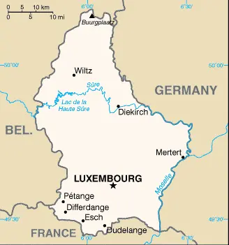
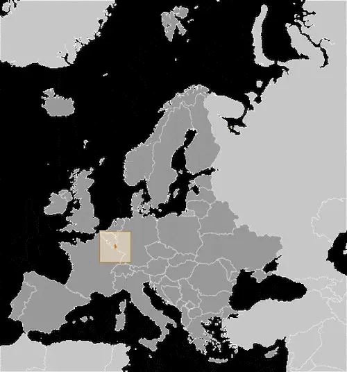
LUXEMBOURG is entirely landlocked, bounded by France in the south, Belgium in the west, and Germany. The northern part of the country is a wooded plateau, known as the Oesling, rising to 550 meters or 1,804 feet.

This region is a continuation of the Ardennes Plateau’s forested hills, where Luxembourg’s high­est peak, Buurgplatz (559 meters or 1,835 feet), is situated.

Read more

Google Maps™ driving directions home » Europe maps

Luxembourg Google Map

This image shows the draft map of Luxembourg, Europe. For more details of the map of Luxembourg, please see this page below. This image shows the location of Luxembourg, Europe. For more geographical details of Luxembourg, please see this page below. This image shows the flag of Luxembourg, Europe. For more details of the flag of Luxembourg, please see this page below.
Borderline map of Luxembourg Location map of Luxembourg Flag of Luxembourg

Luxembourg Google map

Google Maps and Detailed Facts of Luxembourg (LU). This page lets you explore Luxembourg and its border countries (Country Location: Western Europe, between France and Germany) through detailed Satellite imagery – fast and easy as never before Google Maps.

Find comprehensive information about this country’s diversity below: Google maps, geography, economy, science, people, culture, environment, government, and history – All in One Wiki page.

There is also a Street View and free Driving Directions at your service. Your Google Satellite Map Sightseeing in Luxembourg, in Europe, starts here at Driving Directions and Maps.com.

Read more

Google Maps™ driving directions home » Europe maps

Luxembourg Google maps

Luxembourg is one of the most populated cities in Luxembourg, and at the same time, this city is the capital of this country. Located in Europe, you may find the city easily with the following GPS coordinates: 49.37N latitude / 06.09E longitude. For routing in Luxembourg, please check the free driving directions Luxembourg service below.

Read more

Google Maps™ driving directions home » Europe maps

Macedonia

Driving Directions Macedonia

MACEDONIA declared its independence from Yugoslavia in November 1991. The FYROM or Vardar Macedonia is one of the three parts of Macedonia’s ancient, historical kingdom, which also included Aegean Macedonia in Greece and Pirin Macedonia in Bulgaria. Vardar Macedonia only came into being as a republic of Yugoslavia, in 1946, following the victory of the communist forces of Josip Broz Tito.

Its status disputed at the time, and this has contin­ued to be the case. This controversy has been the cause of ongoing dif­ficulties for the FYROM, mainly in gaining much needed international recognition since the collapse of the former Yugoslavia. The government of the FYROM has put into place several measures to encourage eco­nomic growth. It is hoped that having now gained further international recognition, particularly from its neigh­bours since 1996, the country’s economic situation will start to improve.

Read more

Google Maps™ driving directions home » Europe maps

Macedonia Google Map

This image shows the draft map of Macedonia, Europe. For more details of the map of Macedonia, please see this page below. This image shows the location of Macedonia, Europe. For more geographical details of Macedonia, please see this page below. This image shows the flag of Macedonia, Europe. For more details of the flag of Macedonia, please see this page below.
Borderline map of Macedonia Location map of Macedonia Flag of Macedonia

Macedonia Google map

Google Maps and Detailed Facts of Macedonia (MK). This page lets you explore Macedonia and its border countries (Country Location: Southeastern Europe, north of Greece) through detailed Satellite imagery – fast and easy as never before Google Maps.

Find comprehensive information about this country’s diversity below: Google maps, geography, economy, science, people, culture, environment, government, and history – All in One Wiki page.

There is also a Street View and free Driving Directions at your service. Your Google Satellite Map Sightseeing in Macedonia, in Europe, starts here at Driving Directions and Maps.com.

Read more

Google Maps™ driving directions home » Europe maps

Madrid Google maps

Madrid is one of the most populated cities in Spain, and at the same time, this city is the capital of this country. Located in Europe, you may find the city easily with the following GPS coordinates: 40.25N latitude / 03.45W longitude. For routing in Madrid, please check the free driving directions Madrid service below.

Read more

Google Maps™ driving directions home » Europe maps

Malta

Driving Directions Malta

MALTA, situated in the Mediterranean Sea, approximately 288 kilome­tres or 180 miles east of North Africa (Tunisia) and 93 kilometers or 58 miles south of Sicily, is an archipelago of three large inhabited islands and two small uninhabited ones, which together form an independent country of over 376,000 people.

Read more

Google Maps™ driving directions home » Europe maps

Malta Google Map

This image shows the draft map of Malta, Europe. For more details of the map of Malta, please see this page below. This image shows the location of Malta, Europe. For more geographical details of Malta, please see this page below. This image shows the flag of Malta, Europe. For more details of the flag of Malta, please see this page below.
Borderline map of Malta Location map of Malta Flag of Malta

Malta Google map

Google Maps and Detailed Facts of Malta (MT). This page lets you explore Malta and its border countries (Country Location: Southern Europe, islands in the Mediterranean Sea, south of Sicily (Italy)) through detailed Satellite imagery – fast and easy as never before Google Maps.

Find comprehensive information about this country’s diversity below: Google maps, geography, economy, science, people, culture, environment, government, and history – All in One Wiki page.

There is also a Street View and free Driving Directions at your service. Your Google Satellite Map Sightseeing in Malta, in Europe, starts here at Driving Directions and Maps.com.

Read more

Google Maps™ driving directions home » Europe maps

Minsk Google maps

Minsk is one of the most populated cities in Belarus, and at the same time, this city is the capital of this country. Located in Europe, you may find the city easily with the following GPS coordinates: 53.52N latitude / 27.30E longitude. For routing in Minsk, please check the free driving directions Minsk service below.

Read more

Google Maps™ driving directions home » Europe maps

Moldova

Driving Directions Moldova

MOLDOVA is a landlocked, somewhat triangular­shaped republic in southeast Europe that, from 1940 to 1991, was part of the USSR and was called the Moldavian Soviet Socialist Republic. It is bordered by Romania in the west and bounded on all other sides by Ukraine. The River Prut forms the western boundary with Romania, while the River Dnister (Nistru) flows close to the eastern bor­der and coincides with it in the northeast and southeast.

Read more