
Driving Directions and Google Map of Croatia — Roads, Routes & Navigation Guide
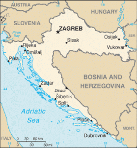
Croatia — Hrvatska in Croatian — is a crescent-shaped country in south-eastern Europe with an extraordinarily diverse geography: a continental heartland centred on Zagreb, a mountainous interior with the Dinaric Alps, and a spectacular 1,800-kilometre Adriatic coastline — one of the most indented and island-studded in the world, encompassing over 1,200 islands, islets, and reefs. The country borders Slovenia to the northwest, Hungary to the northeast, Serbia to the east, Bosnia and Herzegovina to the east and south, Montenegro at its southern tip, and the Adriatic Sea to the west. Croatia’s unusual elongated shape means that driving from the capital Zagreb to the southernmost point of the mainland near Dubrovnik covers roughly 600 km — yet the two regions feel entirely different in climate, road character, and landscape.
Croatia drives on the right-hand side of the road with left-hand drive vehicles. Speed limits are in kilometres per hour. Croatia’s motorway and expressway network uses the A prefix (autocesta) and is operated primarily by HAC (Hrvatske Autoceste d.o.o. — Croatian Motorways) and ARZ (Autocesta Rijeka-Zagreb d.d.). Unlike most of its Central European neighbours, Croatia does not use a vignette sticker or electronic vignette system — instead, tolls are levied at traditional tollbooths and electronic gantries, charged by distance on a per-journey basis. Electronic payment is facilitated by the ENC (Elektronička Naplata Cestarine — Electronic Toll Collection) tag system, interoperable with the wider European Electronic Toll Service (EETS).
The standard drink-drive limit in Croatia is 0.05% BAC, in line with most EU countries — however, drivers under the age of 24, professional drivers, and those on probationary licences are subject to a strict 0.00% BAC limit. Croatia adopted the euro (€ / EUR) as its official currency on 1 January 2023, the same date it joined the Schengen Area. This dual milestone means Croatia is now both a euro-zone and full Schengen state, with no border controls at land crossings with Slovenia and Hungary. The unified emergency number is 112; Croatian dedicated numbers are 192 (police), 194 (ambulance), and 193 (fire brigade). Use the route planner on our homepage to plan your driving routes across Croatia.
The Croatian Road Network
Croatia’s road infrastructure is managed by a combination of state and concession operators. HAC (Hrvatske Autoceste d.o.o.) manages the largest share of the motorway network, including the A1, A3, A4, A5, A11, and A12. ARZ (Autocesta Rijeka-Zagreb d.d.) operates the A6 Zagreb–Rijeka corridor. Istarske ceste manages the Istrian Y motorway network (A8 and A9). Croatia’s total road network is approximately 26,000 km, of which the state road network accounts for approximately 7,000 km. The motorway and expressway network totals approximately 1,400 km.
Croatia’s A-prefix network is notable for two engineering achievements: the routing of major motorways through the Dinaric Alps using long tunnels and viaducts, and the completion of the Pelješac Bridge in 2022, which for the first time connected the Dalmatian hinterland and the Dubrovnik-Neretva County to mainland Croatia by road without passing through Bosnian territory.
Principal motorways and expressways:
- A1 — Zagreb–Karlovac–Gospić–Split–Ploče (~476 km, with extensions, substantially complete): Croatia’s most important motorway, known as the Dalmatinska autocesta (Dalmatian Motorway). The A1 runs the full length of Croatia from Zagreb southward through the Lika region and the Dinaric highlands, descending to Split on the Dalmatian coast, and continuing southward to Ploče at the Neretva delta near the Bosnian border. The Zagreb–Split section (~477 km) is the backbone of Croatian summer tourism: during July and August, this motorway carries enormous volumes of traffic as holidaymakers from Austria, Germany, Hungary, and Slovenia converge on the Dalmatian coast. The A1 passes through or near the notable engineering features of the Sveti Rok Tunnel (~5.7 km, beneath the Velebit mountain range) and numerous viaducts through the Lika karst landscape. Journey time Zagreb–Split approximately 4–4.5 hours.
- A2 — Zagreb–Zaprešić–Krapina–Macelj (Slovenian border, ~56 km): Short motorway connecting Zagreb with the Slovenian border at Macelj/Šentilj, joining the Slovenian A1 toward Celje and Maribor. This is the main motorway route for traffic from Zagreb toward central Slovenia and Austria (via Graz).
- A3 — Bregana (Slovenian border)–Zagreb–Slavonski Brod–Županja–Lipovac (Serbian border, ~306 km): Croatia’s east–west motorway, running through the flat Slavonian plain parallel to the Sava River. The A3 is part of the Pan-European Corridor X (Ljubljana–Zagreb–Belgrade–Niš–Thessaloniki), one of Europe’s most important freight corridors. At Bregana/Obrežje it connects to the Slovenian A2 (toward Ljubljana); at Lipovac/Batrovci it connects to the Serbian A1 (toward Belgrade and southern Europe). Journey time Bregana to Lipovac approximately 3 hours; the Slavonian plain section is fast and largely traffic-free outside of holiday peak periods.
- A4 — Zagreb (Ivanja Reka)–Varaždin–Goričan (Hungarian border, ~96 km): The northern motorway linking Zagreb with Hungary via Varaždin; connects to Hungary’s M7 motorway at Goričan/Letenye toward Budapest (~230 km from Zagreb). Since Croatia joined Schengen in January 2023, the Goričan border crossing operates as a Schengen internal border for EU citizens. Journey time Zagreb–Budapest approximately 3–3.5 hours via A4/M7.
- A5 — Osijek corridor (eastern Slavonia, ~80 km): The A5 designation covers the expressway and planned motorway through eastern Slavonia connecting Beli Manastir (Hungarian border) via Osijek southward through Đakovo toward Šamac (Bosnian border). This corridor serves the agricultural Slavonian region and provides north–south connectivity in eastern Croatia.
- A6 — Zagreb–Karlovac–Rijeka (~165 km, operated by ARZ): The motorway connecting the Croatian capital with the country’s principal port of Rijeka on the Kvarner Gulf. The A6 is a demanding mountain motorway: it crosses the Gorski Kotar highlands and descends steeply to Rijeka, featuring the Tuhobić Tunnel and dramatic viaducts. The Zagreb–Rijeka journey takes approximately 1.5–2 hours. At Rijeka the road connects to the A7 coastal ring and A8/A9 Istrian network. This route is one of the most heavily engineered sections of Croatia’s motorway network.
- A7 — Rijeka ring road and coastal approach (~approx. 25 km): The Rijeka beltway connecting the A6 with the A8 Istrian motorway and the coastal route toward Split (D8). The A7 also includes the approach to the Učka Tunnel (toll), which provides the main link from the Kvarner Bay area into Istria.
- A8 / A9 — Istrian Y Motorway (Istarski ipsilon, ~approx. 106 km): The distinctive Y-shaped motorway network in the Istrian peninsula, operated by Istarske ceste d.o.o. The A8 runs from the Učka Tunnel eastward toward Kanfanar, while the A9 runs north–south along the western Istrian coast from the Slovenian border at Koper/Ferneti to Pula in the south. These motorways serve the major Istrian tourist destinations of Rovinj, Poreč, Pula, and Umag, as well as the crossing to Slovenia and Italy (via Trieste). Tunnel tolls and road tolls apply separately on this network.
- A11 — Zagreb–Sisak (~48 km): Motorway connecting Zagreb southward to Sisak, the gateway to the Sisak-Moslavina county and Kordun region. Extension toward Petrinja and the Bosnian border at Gradiška is planned.
- A12 — Goričan–Zagreb (connector, ~approx. 14 km): Short connector section linking the Goričan Hungarian border crossing to the main Zagreb ring road network, forming the northern approach into Zagreb from Hungary.
State roads (D-prefix): Croatia’s državne ceste (state roads, D-prefix) serve areas not covered by the motorway network. The most important is the D8, the Jadranska magistrala (Adriatic Highway or Magistrala), running along the entire Dalmatian coast from Rijeka to Dubrovnik and beyond. The D8 is one of Europe’s most scenic coastal roads but is extremely congested in summer, particularly between Split and Dubrovnik, and on the narrow sections through the Dalmatian towns. Road surfaces on state roads are generally good; county roads (županijske ceste, Ž-prefix) vary considerably.
Driving Rules and Legal Requirements
The general drink-drive limit in Croatia is 0.05% BAC. However, an absolute 0.00% BAC applies to: drivers aged under 24, professional drivers (bus, taxi, truck), driving instructors, and drivers who have held their licence for less than two years. Breath-testing checkpoints are widespread during summer months, particularly on approach roads to coastal resorts and on major motorways. The Prometna policija takes a strict approach; penalties escalate with BAC level and include heavy fines, licence suspension, and criminal prosecution above 0.15%.
Mandatory year-round headlights: All vehicles must have dipped headlights switched on at all times — day and night, in all weather conditions. This is a year-round requirement with no exceptions. Failure to comply is a fineable offence.
Mandatory equipment: Croatian law requires all vehicles to carry a first-aid kit, a warning triangle, and a high-visibility vest. Unlike some neighbouring countries, a fire extinguisher is not legally mandatory for passenger cars (it is required for commercial vehicles). A spare set of bulbs is strongly recommended. In winter periods (typically 15 November to 15 April), or whenever road conditions require it, vehicles must be equipped with winter tyres or snow chains — this is enforced at mountain passes including the Kapela and Velebit approaches. The requirement may be extended or varied depending on conditions; signs indicating mandatory winter equipment are posted.
Mobile phones: Handheld mobile phone use while driving is illegal. Hands-free calling is permitted. Use of any device that requires manual interaction is prohibited. Fines are significant and enforcement has increased with camera systems in major cities.
Child safety: Children under 12 years or under 150 cm must use an appropriate child restraint system. Children must not travel in the front passenger seat in a rear-facing child seat unless the airbag is deactivated. The child restraint regulations align with EU Regulation ECE R44/04 and R129 (i-Size).
Seat belts: Mandatory for all occupants in all seats. Fines apply to both driver and unbelted passengers.
Towing: Vehicles towing a trailer or caravan are subject to reduced speed limits (see Speed Limits section). The tow bar coupling must be accompanied by registration documentation for the trailer. Caravans and motorhomes are subject to standard size and weight limits; vehicles over 3.5 tonnes require a commercial licence.
Right of way: At unmarked intersections, give way to traffic from the right. Trams have priority over road traffic at all times. On mountain roads with limited width, the ascending vehicle has priority over the descending vehicle. On island and coastal roads without passing places, the vehicle nearest to a widening must reverse to allow passage.
Tunnels: Croatia’s motorway network includes several long tunnels. In all tunnels, headlights must be on (already required permanently by the year-round headlight rule), speed limits are posted, and overtaking is prohibited unless signed otherwise. The major motorway tunnels include Sveti Rok (~5.7 km on A1), Mala Kapela (~5.8 km on A1), and Učka (~5.1 km connecting A7 to Istria, toll applies).
Speed Limits on Croatian Roads
Croatia uses a four-tier speed limit system. All limits are in kilometres per hour (km/h). Radar enforcement is widespread on all road types; fixed cameras are deployed on the A1 and A3, and mobile units operate on national roads.
| Road Type | Cars | With Trailer | Notes |
|---|---|---|---|
| Built-up areas (urban) | 50 km/h | 50 km/h | 30 km/h zones near schools |
| State roads outside towns (D-prefix) | 90 km/h | 80 km/h | May be reduced in mountain sections |
| Expressways (brze ceste) | 110 km/h | 90 km/h | Dual carriageway standard |
| Motorways (autoceste) | 130 km/h | 90 km/h | 100 km/h in tunnels; 80 km/h for vehicles over 3.5 t |
Speed enforcement penalties: Exceeding the limit by up to 10 km/h results in a fine; by 10–30 km/h results in a fine and possible points; by 30–50 km/h results in a larger fine and mandatory licence suspension; by more than 50 km/h results in criminal charges and vehicle immobilisation. On-the-spot fines are issued by the Prometna policija; payment receipts should always be obtained. Foreign drivers may be required to pay fines immediately.
Novice drivers: Drivers who have held their licence for less than 2 years are subject to the 0.00% BAC rule and may face additional speed restrictions on motorways (maximum 110 km/h in some regulatory categories).
Tolls and Road Pricing in Croatia
Croatia uses a distance-based toll system — not a vignette. There is no sticker or electronic vignette to purchase before entering Croatia. Instead, tolls are paid at tollbooths (naplatne rampe) at entry and exit points on motorways, or via electronic gantries. This means you only pay for the sections you use, and the cost depends on the distance driven and the vehicle category.
ENC (Elektronička Naplata Cestarine): Croatia’s electronic toll system uses an ENC transponder (toll tag) that mounts on the windscreen and automatically registers passage through electronic gantries. ENC users save approximately 5–10% on standard toll rates and can use the dedicated ENC lanes at tollbooths, which are significantly faster — important during summer queues. ENC tags are available for purchase or rental at HAC service centres, HAC.hr online, and at some petrol stations near the border. The ENC system is interoperable with the pan-European EETS (European Electronic Tolling Service), so transponders from other EU countries should work, though this should be verified with your home provider.
Payment methods at tollbooths: Cash (euro — since 1 January 2023 the kuna is no longer accepted), credit/debit cards (Visa, Mastercard widely accepted), and ENC tag. American Express acceptance varies by booth.
Approximate toll costs (2025–2026, in EUR, Category I — passenger cars):
| Route Segment | Approx. Toll (EUR) |
|---|---|
| Zagreb – Split (A1, full) | ~€15–18 |
| Zagreb – Rijeka (A6, full) | ~€8–10 |
| Zagreb – Dubrovnik (A1 + D8 coastal) | ~€20–25 (motorway sections only) |
| Učka Tunnel (A7, Rijeka–Istria) | ~€5–7 |
| Zagreb – Hungarian border (A4, Goričan) | ~€5–7 |
| Zagreb – Serbian border (A3, Lipovac) | ~€8–10 |
Toll prices are set annually by HAC and may change; verify current rates at hac.hr or the HAC toll calculator before travel. Motorcycles (Category II) pay reduced rates; vehicles over 3.5 tonnes (Categories III–V) pay substantially higher rates based on axles and weight. The A1 toll from Zagreb to Split is among the highest per-kilometre rates in Central Europe when accounting for the significant infrastructure investment in tunnels and mountain viaducts.
Pelješac Bridge: The Pelješac Bridge, opened in July 2022, connects the Pelješac peninsula to the mainland (Komarna) across the Mali Ston Bay. The bridge is toll-free and is maintained by HAC. Its opening was a major milestone, allowing drivers to travel between mainland Dalmatia and the Dubrovnik-Neretva County entirely on Croatian territory without crossing through Bosnia and Herzegovina via the Neum coastal corridor.
Island bridges and ferries: No road bridges connect the major Dalmatian islands to the mainland — access to islands such as Brač, Hvar, Korčula, and Krk (the latter via the Krk Bridge, which is toll-free since 2021) is primarily by ferry operated by Jadrolinija. Ferry crossings carry passenger vehicles; booking in advance is essential in summer. Krk is the notable exception — the Krk Bridge connects the island directly to the mainland near Rijeka.
Fuel, Electric Vehicles, and Charging
Fuel is readily available throughout mainland Croatia and along the main coastal route. Major motorway service areas on the A1 and A6 maintain 24-hour fuel availability. On islands, fuel stations exist on the larger inhabited islands (Krk, Brač, Hvar, Korčula) but may close early in the evening and have limited opening hours off-season. Tank up on the mainland before boarding ferries.
Fuel types: Unleaded petrol (Eurosuper 95, Super Plus 98), diesel (Eurodizel), LPG (autogas — available at a significant minority of stations), and AdBlue for diesel trucks. The major operators in Croatia include INA (the national oil company), OMV, Petrol, MOL, Shell, and Lukoil. Since the euro adoption in January 2023, all fuel prices are displayed in euros. Fuel prices in Croatia are broadly in line with EU averages and subject to government monitoring under consumer price protection mechanisms.
Electric vehicle charging: Croatia’s EV charging network has grown significantly since 2020 but remains concentrated on the main motorway axes and urban centres. The A1 corridor has fast-charger stations at major service areas between Zagreb and Split. Zagreb, Split, Rijeka, and Dubrovnik have reasonable urban charger coverage. Island charging is limited — Krk has the best coverage among the islands. EV drivers planning the Adriatic coast route are advised to plan charging stops carefully and use apps such as PlugShare, ChargeMap, or the HRPSOR (Croatian Energy Market Operator) charger map for real-time availability. The A6 Rijeka–Zagreb motorway also has fast charging at service areas.
Driving the Adriatic Coast and Islands
The Adriatic coast drive is one of Europe’s most beautiful and most demanding road journeys. The Jadranska magistrala (D8) — Adriatic Highway — runs from Rijeka in the north southward through Zadar, Šibenik, Split, Makarska, and Ploče before continuing as a coastal road toward Dubrovnik. The road is a single-carriageway national road for most of its length, with frequent towns, villages, pedestrian crossings, and junctions demanding constant attention. Overtaking opportunities are limited; caravans and slow vehicles create convoys.
Summer congestion: In July and August, the D8 coastal road and the final southern section of the A1 approaching Split experience extreme congestion, with queues of several hours not uncommon on peak summer weekends (particularly at the start and end of Croatian school holidays). Friday afternoon and Saturday morning arrivals from northern Europe create the worst bottlenecks between Zadar and Split. The A1 motorway, where available, is strongly preferred over D8 for speed — drivers should use A1 as far as it extends and only join D8 for the final section to their coastal destination.
Split–Dubrovnik coastal section: Between Ploče and Dubrovnik (~150 km), there is no motorway. This section follows D8 through the spectacular Makarska Riviera, past Omiš, and through the Neretva delta. The road is largely single carriageway; summer queues are common. Since the opening of the Pelješac Bridge in July 2022, the route to Dubrovnik no longer requires crossing through Bosnia at Neum — the new A1 extension (Ploče) and the Pelješac Bridge have significantly improved journey times for this final leg. Journey time Split–Dubrovnik is approximately 2.5–3.5 hours depending on traffic and season.
Driving in Dubrovnik: Dubrovnik is Croatia’s most-visited destination and among the most congested small cities in Europe during summer. The historic Old Town (Stari Grad) is entirely pedestrianised; the approach roads from the north (D8 and D8002) funnel into the narrow Dubrovnik riviera, causing severe tailbacks in summer. A park-and-ride system at Dubrava helps reduce traffic entering the city centre. Visiting in shoulder season (May–June or September–October) enormously improves the driving experience. Cruise ship arrivals create midday crowds regardless of season.
Island driving: Islands are reached primarily by Jadrolinija ferries or fast catamaran services (foot passengers only). Car ferries operate to Brač (Supetar), Hvar (Stari Grad), Korčula (Vela Luka and Dominče), Vis, and many smaller islands. Once on an island, roads are typically narrow, winding, and unmarked — suitable for normal passenger cars but unsuitable for large vehicles. Scooter hire is popular on islands; helmets are mandatory. Parking on islands is in short supply; town centres on Hvar Town and Korčula Town have extremely limited vehicle access.
Krk Island (Kvarner): Krk is connected to the mainland by the Krk Bridge (toll-free since 2021), a graceful two-arch road bridge near Rijeka. Krk is the largest Croatian island and has the most developed road infrastructure. Rijeka/Krk Airport (RJK) is located on the island. The coastal towns of Krk Town, Baška, and Malinska are reachable by road from the bridge.
Driving in Zagreb, Split, and Dubrovnik
Zagreb: Croatia’s capital and largest city (~800,000 population, ~1.1 million metropolitan) is a compact and relatively manageable Central European capital for driving. The city is served by a ring road system and has a well-developed public transport network (trams, buses). Trams crisscross the city centre and tram routes have priority; drivers must yield to trams and must not block tram tracks. The city centre (Gornji Grad and Donji Grad) has extensive resident parking zones (zones 1–3) requiring paid parking via the ZET/ZP parking app or parking meters. The A1, A2, A3, A4, and A11 motorways all originate from or terminate at the Zagreb orbital road, making Zagreb the hub of the entire national motorway network. The Zagreb Ring Road (Zagrebačka obilaznica) partially circumvents the city but is frequently congested during peak hours.
Split: Croatia’s second-largest city and the gateway to central Dalmatia (~200,000 population) sits at the foot of the Mosor Mountains on the Adriatic coast. The A1 motorway terminates at a junction north of Split, feeding traffic into the urban approach roads. The city centre around Diocletian’s Palace is a UNESCO World Heritage Site with extremely limited vehicle access — parking is concentrated in structured car parks at the edge of the historic core. The Split Ferry Terminal (trajektna luka) handles high volumes of vehicle ferry traffic to the islands and is adjacent to the city centre, creating significant congestion. The area around the ferry terminal and the coastal Riva promenade experiences the worst bottlenecks during summer ferry departures.
Dubrovnik: With a permanent population of only about 40,000, Dubrovnik’s infrastructure is completely overwhelmed by the millions of tourists who visit annually. The approach road from the north (D8/E65) passes through the Rijeka Dubrovačka bay and reaches the city via the coastal road. The Dubrovnik bypass tunnel system (Gruška obilaznica) provides some relief; however, the routes to cable car parks, beaches, and the Old Town remain severely congested in summer. Visitors are strongly advised to use the park-and-ride at Dubrava (located above the city) with shuttle bus connections, rather than attempting to drive to the Old Town area. Parking within the city is extremely expensive and scarce.
Border Crossings with Neighbouring Countries
Croatia shares land borders with five countries — Slovenia, Hungary, Serbia, Bosnia and Herzegovina, and Montenegro — and maritime borders with Italy across the Adriatic. Since joining Schengen on 1 January 2023, borders with Slovenia and Hungary are internal Schengen borders for EU citizens (no passport checks). The Serbia, Bosnia and Herzegovina, and Montenegro borders remain full external border checks.
Slovenia (multiple crossings — internal Schengen):
- Bregana / Obrežje (A3 ↔ Slovenian A2): The busiest motorway crossing; main route for traffic between Zagreb and Ljubljana (and onward to Austria and western Europe). Corridor X designation. No border stop for EU citizens since January 2023.
- Macelj / Šentilj-Gruškovje (A2): Northern crossing toward Maribor and Graz (Austria); connects to the Slovenian A1.
- Rupa / Jelšane (A6 ↔ Slovenian A1): Main crossing for the Rijeka–Ljubljana motorway corridor; connects to the Slovenian A1 toward Ljubljana and Trieste.
- Pasjak / Starod: Alternative coastal crossing near Rijeka used for road traffic between Kvarner and Slovenian Istria.
- Kaštel / Dragonja (D8 coastal road): Border crossing on the Adriatic coast near Piran (Slovenia); main crossing for traffic to and from the Slovenian coast.
Hungary (2 main crossings — internal Schengen):
- Goričan / Letenye (A4 ↔ Hungarian M7): Main motorway crossing; highest traffic volume for Croatia–Hungary traffic. M7 connects to Budapest (~230 km). No passport checks since January 2023.
- Terezino Polje / Barcs: Secondary road crossing in the Podravina region; connects to Hungarian roads toward Pécs.
Serbia (2 crossings — full border checks):
- Lipovac / Batrovci (A3 ↔ Serbian A1): Main motorway crossing on Corridor X; heaviest freight and passenger traffic between Croatia and Serbia. Queues can be long, particularly during holiday periods and for heavy goods vehicles. Journey time Zagreb–Belgrade via this crossing approximately 4.5–5 hours.
- Ilok / Bapska: Secondary crossing on the Danube in eastern Slavonia; used for local traffic and Danube tourist routes.
Bosnia and Herzegovina (numerous crossings — full border checks): Croatia surrounds much of Bosnia and Herzegovina geographically; there are approximately 20 official crossings. The most important for tourists are:
- Slavonski Brod / Slavonski Brod (Bosnia): Largest crossing in central Slavonia; road and rail bridge over the Sava.
- Stara Gradiška / Gradiška: Western Slavonian crossing; significant freight traffic.
- Karamatić / Orašje (northern Bosnia): Cross-border commuter and freight crossing.
- Neum / Neum (coastal): The short section of D8 coastal road that previously crossed through Bosnia at Neum to reach Dubrovnik. Since the Pelješac Bridge opened in 2022, most tourist traffic bypasses Neum entirely, though the crossing remains open.
- Kamensko / Bilaj and Maljevac / Velika Kladuša (Una-Sana region): Crossings in the Lika and Kordun region for traffic to Bihać and northwestern Bosnia.
Montenegro (1 road crossing):
- Karasovići / Karasovići (D8 / E65): The only official road crossing between Croatia and Montenegro, south of Dubrovnik on the coastal road. Full border checks apply. Used primarily by tourists continuing along the Adriatic coast toward Kotor, Budva, and Tivat. Wait times in summer can be 1–3 hours.
Road Safety and Emergency Procedures
Croatia’s road safety record has improved substantially since EU accession in 2013, with fatalities per million inhabitants declining in line with EU safety directives. The primary risk factors for foreign visitors are: fatigue-related accidents on long A1 motorway journeys (particularly during summer when traffic volumes are extreme), distraction on the scenic but demanding D8 coastal road, underestimating distances and journey times between Dalmatian destinations, and alcohol-related incidents at coastal resorts. Narrow island roads present an additional hazard for inexperienced drivers.
In an emergency: Call 112 — the unified EU emergency number. Croatian specific numbers are 192 (Policija), 194 (Hitna medicinska pomoć — Ambulance), and 193 (Vatrogasna služba — Fire). HAC (motorway operator) has its own road assistance line — 0800 9909 (toll-free from Croatia) for motorway breakdowns. The Croatian Automobile Club (HAK — Hrvatski Autoklub) also operates a roadside assistance service: 1987.
Breakdown procedure: On motorways and expressways, use the hard shoulder immediately if possible. Deploy your warning triangle at least 100 metres behind the vehicle. Don a high-visibility vest before stepping out of the vehicle. Emergency phones are located at 2 km intervals on the A1 and A6. On single-carriageway roads, make the vehicle as visible as possible using hazard lights and the warning triangle.
HAK (Croatian Automobile Club): HAK publishes real-time road condition information, border crossing wait times, and ferry schedules at hak.hr and via the HAK app. During summer peak periods, HAK broadcasts road conditions on Radio HAK (100.5 FM) with updates specifically aimed at holiday traffic. Checking HAK before a summer Dalmatian journey is strongly recommended.
Weather and seasonal hazards: The bura — a cold, powerful north-easterly katabatic wind — can close coastal roads and bridges (including the Krk Bridge and the A1 Maslenica viaduct section) at short notice and without warning. The bura can reach speeds exceeding 150 km/h in gusts and is particularly common in the Velebit mountain face and the Zadar channel. Wind speed signage on the coastal motorway sections indicates restrictions for high-sided vehicles and caravans. In summer, the jugo (warm south-easterly wind) brings poor visibility and sea fog. In winter, the Lika plateau section of the A1 and the A6 Gorski Kotar section can experience heavy snowfall and ice — chains or winter tyres may be required.
FAQ: Driving in Croatia
Do I need a vignette for Croatia?
No. Croatia does not use a vignette system. Motorway tolls are charged per journey at tollbooths, based on the distance you travel. You pay at the booth when you exit the motorway — either in cash (euros), by card, or via the ENC electronic transponder tag. There is no sticker or digital vignette to purchase in advance. Simply drive to the tollbooth and pay when you exit.
What is the drink-drive limit in Croatia?
The standard limit is 0.05% BAC for most adult drivers. However, drivers under 24 years of age, professional drivers (bus, taxi, truck, instructor), and those in the first two years after obtaining their licence are subject to strict 0.00% BAC — absolute zero tolerance. Police conduct roadside breath tests routinely, particularly on Dalmatian approach roads and motorways in summer. Any detectable alcohol above your applicable limit results in fines and possible licence suspension.
Do I need to buy a vignette or pay a toll to reach Dubrovnik?
Travel from Zagreb to Dubrovnik involves motorway toll sections on the A1 (Zagreb–Ploče, approximately €18–20 total in tolls) plus the Pelješac Bridge section. The Pelješac Bridge itself is toll-free. The coastal section on D8 between the A1 terminus and Dubrovnik carries no toll — it is a regular national road. Total one-way motorway tolls Zagreb–Dubrovnik are approximately €20–25 for a Category I passenger car.
Can I drive to the islands in Croatia?
Krk is the only major Croatian island accessible by road bridge (the Krk Bridge, toll-free since 2021). All other major Dalmatian islands — Brač, Hvar, Korčula, Vis, Šolta, Lastovo — require a vehicle ferry crossing. Car ferries are operated by Jadrolinija and some private operators. Booking ferry space for your vehicle well in advance is essential during July and August; popular routes such as Split–Supetar (Brač) and Split–Stari Grad (Hvar) can sell out days ahead.
Is the Adriatic coastal road (D8) suitable for all drivers?
The D8 Adriatic Highway is suitable for standard passenger cars but requires attentive driving. The road is single carriageway for most of its length, passes through many coastal towns and villages, and features sharp bends with sea cliffs on one side and drop-offs on the other in some sections. It is not recommended for large motorhomes or caravans beyond Ploče. In summer, patience is essential — expect convoys of slow traffic. EV drivers should note that D8 has limited fast-charging infrastructure compared to the A1 motorway.
Is Croatia in the Schengen Area?
Yes. Croatia joined the Schengen Area on 1 January 2023, the same date it adopted the euro. Land border controls between Croatia and Slovenia (to the northwest) and Croatia and Hungary (to the northeast) were lifted at midnight on 1 January 2023. EU citizens no longer face passport checks at these crossings. Borders with Serbia, Bosnia and Herzegovina, and Montenegro remain full external EU border crossings with document checks.
What is the bura wind and how does it affect driving?
The bura is a powerful, cold, dry north-easterly katabatic wind that descends from the Dinaric Alps to the Adriatic coast. It can reach destructive speeds (60–150+ km/h) with little warning and is most common in winter and spring, though it can occur year-round. The bura is particularly dangerous for high-sided vehicles, caravans, and motorcycles on coastal roads and the Maslenica bridge/viaduct section of the A1. Variable message signs and wind restriction gantries indicate current restrictions. Never ignore bura wind warnings — the wind can knock a caravan off a road at high speeds.
Do I need headlights on during the day in Croatia?
Yes. Croatia requires dipped headlights to be switched on at all times — day and night, year-round, in all weather conditions. This is a firm legal requirement, not an advisory. Failure to have headlights on during daytime results in an on-the-spot fine from the Prometna policija (Traffic Police).
Sources and Update Note
This Croatia driving guide draws on information from HAC (Hrvatske Autoceste — hac.hr), ARZ (Autocesta Rijeka-Zagreb — arz.hr), Istarske ceste (istra-autocesta.hr), HAK (Hrvatski Autoklub — hak.hr), the Croatian Ministry of the Interior (mup.gov.hr) for traffic regulations, the European Commission transport and road safety statistics, Jadrolinija (jadrolinija.hr) for ferry information, and OpenStreetMap contributor data verified against satellite and official infrastructure sources. Schengen and euro adoption dates are sourced from official EU Council documentation. Pelješac Bridge opening confirmed from Croatian government sources.
Croatia’s infrastructure is actively developing — new motorway sections, ferry route adjustments, and toll price revisions occur annually. Verify current toll rates at hac.hr (toll calculator), current road and ferry conditions at hak.hr, and island ferry schedules at jadrolinija.hr before travel. This guide reflects information current as of February 2026.