
Driving Directions and Google Map of Finland — Roads, Routes & Navigation Guide
Finland — Suomi in Finnish, Finland in Swedish — is the northernmost country in the European Union, covering 338,145 km² across the forested lake plateau of the Fennoscandian shield. The country is defined by its extraordinary natural landscape: approximately 188,000 lakes (more lakes relative to country area than anywhere else on Earth), 75% forest cover, a 1,250 km Baltic Sea coastline with a 40,000-island outer archipelago, and a vast Arctic north (Lappi — Finnish Lapland) stretching some 300 km above the Arctic Circle. Finland shares borders with Sweden to the west (the Torne River border), Norway to the northwest and north, and Russia to the east and southeast — though the Finland–Russia land border has been closed to general civilian traffic since late 2023.
Finland drives on the right-hand side of the road with left-hand drive vehicles. Speed limits are in kilometres per hour. The road network is managed by Väylävirasto (Finnish Transport Infrastructure Agency) for national roads and by ELY Centres (regional government agencies) for regional roads. Finland uses E-prefix European routes (E18, E75, E8, etc.), national roads (valtatie, VT), and regional roads (kantatie, KT) for primary roads. Finland is one of the rare European countries with no motorway tolls and no national road vignette — all motorways and national roads are free to drive on.
Finland’s drink-drive limit is 0.05% BAC for general drivers — at the EU standard level, in contrast to its Scandinavian neighbours Norway and Sweden which enforce the stricter 0.02% limit. Professional drivers (bus, taxi, heavy goods) face a 0.02% BAC limit. The currency is the euro (€) — Finland adopted the euro in 2002 as one of the original eurozone countries. Finland is a full Schengen Area member (open borders with Sweden and Norway) and joined NATO in April 2023, ending its decades-long policy of military non-alignment. The single emergency number is 112 for all services. Use the route planner on our homepage to plan your journey across Finland.
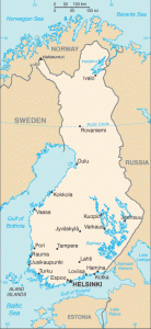
The Finnish Road Network
Finland’s road network is managed by Väylävirasto (Finnish Transport Infrastructure Agency) for national (valtatie) and regional (kantatie) roads, totalling approximately 17,700 km of state roads. County and local roads bring the total network to approximately 454,000 km. Finland’s approximately 930 km of motorways (moottoritie) are concentrated in the Helsinki metropolitan area and the southern triangle between Helsinki, Tampere, and Turku — reflecting the fact that about a third of Finland’s population of 5.6 million lives in this compact region. The sparse population of central and northern Finland means that even primary national roads north of Tampere are predominantly single-carriageway, often running through long stretches of forest with no services for 50–100 km.
Finland’s road numbering distinguishes national roads (VT 1–29, which include E-route designations), regional roads (KT 40–99), and county/municipal roads. E-routes follow the pan-European numbering convention. Many Finnish roads run perfectly straight for long distances through flat boreal forest — this characteristic can create significant monotony and driver fatigue; rest stops (levähdysalue) are provided at intervals on main roads.
Primary E-roads and national routes:
- E18 — Turku–Helsinki–Porvoo–Kotka–Vaalimaa (Russian border, ~370 km): Finland’s most important east–west arterial and the gateway from the west (Turku ferry terminal from Stockholm) to Helsinki and on to the Russian border. The E18 is motorway standard between Turku and Helsinki (VT 1, the Helsinki–Turku motorway, completed in sections) and between Helsinki and Kotka (VT 7, the King’s Road / Via Regia). East of Kotka, the E18 continues as VT 7 through Hamina to the Vaalimaa border crossing with Russia — though this crossing is presently closed to most civilian traffic (see Border Crossings section). The Helsinki–Turku section (~165 km) takes approximately 1.5–2 hours by motorway; Helsinki–Kotka (~130 km) approximately 1.5 hours.
- E75 — Helsinki–Lahti–Jyväskylä–Oulu–Rovaniemi–Nuorgam (Norwegian border, ~1,300 km): Finland’s primary north–south arterial and the longest Finnish national road. The E75 (VT 4) begins at Helsinki as a motorway through Lahti, then continues through Jyväskylä and northward through the Oulu coastal plain, Rovaniemi (Arctic Circle; capital of Lapland; the “official hometown of Santa Claus”), and on through Finnish Lapland to the Norwegian border at Nuorgam–Utsjoki on the Teno River. The E75 north of Rovaniemi is single-carriageway through the Arctic wilderness; north of Inari, it follows the Teno River valley toward the Arctic Ocean. Journey time Helsinki–Oulu approximately 6 hours (600 km); Helsinki–Rovaniemi approximately 8–9 hours (830 km); Helsinki–Nuorgam approximately 14–15 hours (1,300 km).
- E8 — Turku–Tampere–Oulu–Tornio (Swedish border, ~710 km): The western corridor from Turku northward through Tampere (Finland’s second city), continuing up the west coast through Pori, Vaasa (ferry port for Umeå, Sweden), and Oulu to Tornio — the Finnish side of the twin cities of Haparanda–Tornio on the Swedish border. The E8 is motorway standard between Turku and Tampere (VT 3); north of Tampere it becomes high-quality single or dual carriageway. Journey time Turku–Tampere approximately 2 hours (165 km); Tampere–Oulu approximately 3.5 hours (295 km).
- E63 — Turku–Tampere–Jyväskylä–Kuopio–Joensuu (connecting lake region ~500 km): The central diagonal from Turku through Tampere and into the Finnish lake district heartland, passing Jyväskylä (university city and motorsport heritage centre — Jyväskylä Rally, the Finnish round of the WRC, is the most famous rally event in Nordic motorsport) and Kuopio on the shores of Lake Kallavesi. The E63 connects the lake district cities of central Finland with the south.
- E12 — Oulu–Kajaani–Joensuu (~500 km, the Blue Highway, east–west): The Finnish section of the international Blue Highway (E12), running eastward from the Gulf of Bothnia coast at Oulu through the forest and lake landscapes of Kainuu (reindeer country) to Joensuu (gateway to Karelia and the North Karelian lakes). The E12 continues into Russia — though the border crossings (Vartius–Lyttä and Niirala–Värtsilä) are currently closed to general civilian traffic.
- VT 21 — Tornio–Muonio–Kilpisjärvi (Norwegian border, ~485 km, the Arctic Road in Finnish Lapland): The Finnish Arctic Road, running along the Swedish border up the Torne River valley from Tornio to the mountain area (tunturit) of northwestern Lapland, passing through Muonio and Enontekiö (Hetta) to Kilpisjärvi at the tripoint where the borders of Finland, Sweden, and Norway meet. The Kilpisjärvi area sits at 480 m above sea level in the Arctic fells — the road continues into Norway as E8 toward Tromsø. This is one of Finland’s most dramatic road journeys, with treeless Arctic fell landscape, reindeer herds, and the midnight sun in summer or northern lights in winter.
Ferries as part of Finland’s road network: Finland’s vast archipelago — the largest in the world by island count — includes hundreds of free state-operated ferry crossings (lossi or lautta) that form part of the national road network. These ferries are free to use (funded by the state as part of the road infrastructure) and run on schedules typically every 15–60 minutes. The most famous archipelago ferry roads are around Turku and the Archipelago Trail (Saaristotie). Finland also has extensive international car ferry connections: Helsinki and Turku are major terminals for routes to Stockholm (Tallink Silja, Viking Line — overnight sailings), Tallinn, Estonia (Tallink, Eckerö, Viking Line — 2 hours), and Germany (Finnlines).
Driving Rules and Legal Requirements
Finland’s drink-drive limit of 0.05% BAC for general drivers is at the EU standard — somewhat more permissive than the 0.02% limits in neighbouring Norway and Sweden. However, Finland enforces the limit rigorously: Finnish Police (Poliisi) conduct frequent breathalyser checkpoints throughout the country, and drink-driving offences carry severe consequences including criminal records, high fines (income-proportional day-fines), and mandatory driving licence suspension. Professional drivers (buses, taxis, lorries) face a 0.02% BAC limit equivalent to the Swedish and Norwegian standard. A first offence at 0.05–0.12% BAC constitutes a petty drink-driving offence (rattijuopumus); above 0.12% is aggravated drink-driving (törkeä rattijuopumus), which carries near-certain prosecution and often imprisonment for repeat offenders.
Mandatory headlights: All vehicles must use headlights (dipped headlights or daytime running lights) at all times while driving, regardless of time of day or weather. This requirement has been in force in Finland for decades.
Speed cameras: Finland operates an extensive network of fixed speed cameras (automaattinen nopeudenvalvonta) on national roads and motorways, plus average speed control sections (matkavalvonta / matkamittausvalvonta) on selected routes. Average speed control measures elapsed time between entry and exit camera points and calculates average speed; exceeding the average limit issues an automatic fine. Camera locations are published and available in GPS navigation apps. Mobile police radar units are also used. Finnish fines are income-proportional day-fines (päiväsakko); speeding fines can reach tens of thousands of euros for high-income drivers.
Winter tyres — mandatory in Finland: Winter tyres (talvirengas) are legally mandatory in Finland from 1 December to the last day of February, whenever winter road conditions exist (effectively mid-October to mid-April in the south; longer in Lapland). The law requires tyres suitable for winter conditions (marked with the M+S or snowflake symbol) when the road surface is slippery due to snow, slush, or ice. Studded tyres (nastarengas) are permitted from 1 November to the first Monday after Easter Sunday. Studded tyres are widely used in Finland due to the severity of ice conditions; they provide significantly better grip on compacted snow and ice compared to non-studded friction tyres. Driving on summer tyres in Finnish winter conditions is dangerous and illegal.
Mobile phones: Using a handheld mobile phone while driving is prohibited. Fines are substantial. Hands-free calling and navigation use is permitted.
Seat belts: Mandatory for all occupants in all seats. Children up to 135 cm in height must use an appropriate child restraint system; rear-facing child seats are used and recommended for younger children consistent with Scandinavian safety culture.
Wildlife hazards — elk (hirvi) and reindeer (poro): Finland has approximately 90,000–120,000 elk (hirvi — Eurasian moose), and elk–vehicle collisions are a serious road safety hazard resulting in several fatalities and over 3,000 vehicle collisions per year. Elk warning signs (hirvivaroitusmerkki) mark active collision zones, particularly in forest corridors at dusk and dawn. In Finnish Lapland, reindeer are semi-domestic animals that cross roads freely throughout Sami reindeer-herding territories; collisions with reindeer are common and drivers are legally liable for damage to reindeer. Drive slowly through reindeer warning zones and be prepared to stop for animals at any time, day or night. Over 4,000 reindeer are killed in traffic annually in Finnish Lapland.
Yielding and priority rules: Finland follows standard right-hand traffic priority rules: yield to traffic from the right at unmarked intersections. Roundabouts give priority to circulating traffic. Trams have priority over cars at intersections and tram stops — pedestrians boarding or alighting from trams must be given right of way even in the street.
Speed Limits on Finnish Roads
Finland’s speed limit system includes a distinctive and internationally notable feature: seasonal motorway speed limits. Many Finnish motorways and high-quality national roads have two speed limits — a higher summer limit and a lower winter limit — posted on variable message signs and fixed supplementary signs. The winter limit is typically in force from 1 November (or 1 December) through late March, though the exact dates are set by Traficom (Finnish Transport and Communications Agency) annually based on road conditions.
| Road Type | Summer Limit | Winter Limit | Notes |
|---|---|---|---|
| Urban / built-up areas | 50 km/h | 50 km/h | 30–40 km/h in school zones and residential streets |
| Rural national roads | 80 km/h | 80 km/h | 60–100 km/h depending on road quality; some sections 100 km/h summer |
| High-quality national roads | 100 km/h | 80–100 km/h | Reduced in winter conditions |
| Motorways (moottoritie) | 120 km/h | 100 km/h | 120 km/h on best motorway sections (summer only); reduced to 100 km/h Dec–Feb on most motorways |
Speed enforcement: Finnish fines follow the day-fine (päiväsakko) system, proportional to the offender’s net daily income. For minor speeding (1–15 km/h over limit), a fixed fine notice (rikesakko) of €170 applies without court involvement. For 16+ km/h over the limit, the income-proportional day-fine system applies — this has resulted in some of the largest speeding fines ever issued in Europe: Finnish millionaires have received fines exceeding €100,000 for motorway speeding. Exceeding the limit by 50+ km/h results in criminal charges regardless of income. Driving licence suspension follows serious or repeat offences.
Tolls and Road Costs — Free Motorways
Finland is one of a small number of European countries that operates no tolls and no national road vignette. All Finnish motorways, national roads, regional roads, and county roads are free to use. There are no toll booths, no electronic toll gantries, no congestion charging zones in Helsinki, Tampere, Turku, or any Finnish city, and no bridge or tunnel tolls on public roads. This is a deliberate policy choice — road infrastructure in Finland is financed through general taxation (vehicle tax, fuel excise duty, and the motor vehicle tax system).
For drivers arriving in Finland by international car ferry — the most common route for visitors from Sweden, Estonia, or Germany — the ferry fare is the primary transport cost. Overnight Helsinki–Stockholm ferry crossings (operated by Tallink Silja Line and Viking Line) typically cost €80–250 for a car plus cabin, depending on sailing and season. Helsinki–Tallinn crossing (2 hours) is €30–80 for a car. These ferries are comfortable cruise-style ships; the Helsinki–Stockholm overnight sailing across the Baltic is an experience in itself.
State-operated road ferries are free: The dozens of free state ferry crossings (lossi / lautta) that form part of the national road network are operated at no charge to the user — they are financed as part of the road budget. This includes the Archipelago Trail ferry crossings and numerous crossings across Finnish rivers, lakes, and coastal channels.
Future developments: Finland has debated road user charging and distance-based tolls as a means of replacing fuel excise revenue lost to EV adoption, but as of 2026, no toll system has been introduced. Visitors should verify the current situation at Traficom (traficom.fi) in case a new system is introduced.
Fuel, Electric Vehicles, and Charging
Fuel stations are widespread across southern and central Finland. In northern Finland and Finnish Lapland, stations can be 80–150 km apart on some routes, including sections of the E75 north of Rovaniemi and VT 21 in northwestern Lapland. Many rural stations operate unmanned 24-hour payment terminals — carry a chip-and-PIN card and check for any station ahead on navigation apps before entering a long remote section. Major fuel brands include Neste (Finland’s national oil company, also the world’s largest producer of renewable diesel), St1, ABC (S-Group service stations, often attached to S-market supermarkets), and Shell. Neste’s renewable HVO100 diesel is widely available and popular as a lower-emission option. E10 petrol (10% ethanol) has been standard since 2011.
Electric vehicles: Finland has a rapidly growing EV sector driven by government incentives and the high environmental awareness characteristic of Nordic countries. EV adoption is growing, particularly in the Helsinki metropolitan area. Key EV facts:
- Fast DC charging (50–150 kW): Available at regular intervals along E18 (Helsinki–Turku, Helsinki–Kotka), E75 (Helsinki–Lahti–Jyväskylä–Oulu), and E8 (Tampere corridor). Operators include Recharge, Virta, IONITY, Neste, ABC (S-Group), and Tesla Supercharger. EV charging at ABC service station sites (common at motorway service areas) is widespread.
- Northern Finland and Lapland: EV charging coverage becomes sparse north of Oulu. Charging infrastructure along E75 reaches Rovaniemi and has been extended toward Saariselkä and Ivalo; beyond Ivalo, planning an Arctic EV trip requires careful research. Cold Arctic temperatures (−30°C to −40°C) significantly reduce battery range — plan for 30–40% range reduction in extreme cold.
- Ferry charging: Several Tallink Silja and Viking Line Baltic ferries have Type 2 EV charging points in the car deck. Domestic lake and archipelago state ferries may also have charging points at some terminals.
- Neste renewable diesel: For diesel vehicle drivers seeking reduced emissions, Neste MY Renewable Diesel (HVO100) is available at many Neste stations and reduces lifecycle CO2 emissions by up to 90% compared to fossil diesel.
Scenic Drives and Notable Road Journeys
The Arctic Road — E75 Rovaniemi to Nordkapp (via Norway, ~720 km from Rovaniemi): One of Europe’s great adventure drives, the E75 north from Rovaniemi follows the E75 through Finnish Lapland to the Norwegian border at Nuorgam (on the Teno River) and then continues as the Norwegian E75 toward Nordkapp (North Cape). The Finnish section passes through the Saariselkä wilderness resort, Inari (on the vast Inari Lake — the third-largest lake in Finland), Lemmenjokilaajoksi National Park, and the remote Utsjoki municipality — one of the least populated municipalities in Finland, straddling the Teno River on the Norwegian border. The drive from Rovaniemi to the Norwegian border at Nuorgam is approximately 400 km (4.5–5 hours) of Arctic wilderness road with reindeer, fell landscapes, and in midsummer, the midnight sun. North Cape / Nordkapp is approximately 320 km further into Norway.
The Archipelago Trail (Saaristotie — Turku archipelago, ~250 km ring route): The Archipelago Trail is a circular route through the outer Turku archipelago, combining regular roads with free state-operated car ferry crossings. The trail visits hundreds of small islands, connecting fishing villages, rocky coastal farmsteads, old pilots’ cottages, and the Red Granite landscapes of the outer archipelago. The route includes several ferry crossings (free, run by the state); the full circuit from Turku takes 1–2 days depending on stops. This is one of Finland’s most distinctive and rewarding drives — the archipelago between Finland and Sweden is the largest archipelago in the world by number of islands (approximately 40,000–50,000 islands, islets, and rocks in the Turku Archipelago Sea alone). Best done in late spring–summer when all ferries run and the archipelago is in bloom.
The King’s Road (Kuninkaantie — E18 / VT 7 Helsinki to Turku / Helsinki to Viborg, ~950 km historically): The King’s Road is a historic postal and trade route dating to the medieval period, running along the southern coast of Finland. The modern E18 follows much of its eastern section; the section from Turku to Helsinki and east to Porvoo and Kotka offers a scenic coastal alternative to the fastest route. The heritage towns of Porvoo (Finland’s second-oldest city, a picturesque Old Town of ochre-painted wooden buildings) and Loviisa are on this route. Porvoo Old Town is one of Finland’s most visited cultural destinations; the red riverside warehouses of the vanha kaupunki (old town) are an iconic Finnish image.
The Lakeland road — Lake Saimaa and Lake Päijänne region (around VT 6, 9, 13): The Finnish lake district — centred on Lake Saimaa (the fourth-largest lake in Europe by surface area) and Lake Päijänne (Finland’s second-largest and deepest lake) — offers driving through a landscape of extraordinary beauty: forest roads between glittering lake surfaces, causeways across narrow lake channels, panoramic lake viewpoints, and lakeside spa hotels. The region around Savonlinna (site of the medieval Olavinlinna Castle, host to the Savonlinna Opera Festival) and Lappeenranta (on Lake Saimaa) is particularly rewarding. The Lakeland driving loop between Lahti, Jyväskylä, Mikkeli, Savonlinna, and Lappeenranta covers some of the most characteristic Finnish scenery.
Ruka and Kainuu wilderness roads: The area around Ruka (near Kuusamo, in Kainuu), combined with the nearby Oulanka National Park, offers driving through pristine boreal wilderness. The road to Ruka from Oulu (VT 20 and 5) passes through vast spruce and pine forest. Oulanka’s famous Karhunkierros (“Bear’s Trail”) hiking circuit is accessed by road from Ruka. The Kuusamo area is also a gateway for bear- and wolverine-watching safaris — Finland has the largest brown bear population in the EU.
The Pallas-Yllästunturi road — Finnish fell country: VT 79 from Rovaniemi north toward Pallas-Yllästunturi National Park (Finland’s most visited national park) and Enontekiö traverses the characteristic Arctic fell (tunturi) landscape of western Finnish Lapland — the only area of Finland where the treeline is crossed and the terrain becomes open Arctic tundra. The road passes through Kittilä (site of Levi, Finland’s largest ski resort) and Muonio.
Driving in Helsinki, Tampere, and Turku
Helsinki: Finland’s capital (~660,000 city / ~1.5 million metropolitan area) is built on a peninsula jutting into the Gulf of Finland, surrounded by sea and islands. Driving in central Helsinki is straightforward compared to many European capitals — there are no congestion charges, no LEZ (low emission zone) as of 2026, and parking — while paid and sometimes difficult to find — is not as restrictive as in Stockholm or Oslo. The main ring road system consists of Ring Road I (Kehä I / MT101) — the inner city bypass running from Espoo through Vantaa east of the city — and Ring Road III (Kehä III / E18) — the outer motorway ring linking Helsinki-Vantaa Airport to the major radial motorways. The E18 West (Helsinki–Turku direction) and E75 North (Helsinki–Lahti direction) are the main departure routes from the capital. The Helsinki–Vantaa Airport (Finland’s main international airport) is located on Ring Road III, approximately 19 km north of the city centre; driving time to the city centre from the airport is 20–30 minutes outside peak hours. Helsinki’s public transport (metro, tram, bus) is excellent; the centre is best explored on foot or by tram.
Tampere (Tammerfors): Finland’s second-largest urban area (~245,000 city / ~390,000 metropolitan), located between lakes Näsijärvi and Pyhäjärvi on a narrow isthmus. Tampere is a major industrial and logistics city at the junction of the E8 (north–south) and E12 / VT 3 (toward Helsinki) corridors. The Tampere ring road (Tampere kehätie) redirects through traffic around the city. Tampere is noted for its red-brick industrial heritage (converted textile mills along the Tammerkoski rapids), cultural venues, and the Tampere–Helsinki intercity rail corridor — one of Finland’s busiest rail links. For road travellers, Tampere is the primary junction for routes to the west (Vaasa, Pori), east (Jyväskylä), south (Helsinki), and north (Oulu, Lapland).
Turku (Åbo): Finland’s sixth-largest city (~200,000) and historic first capital. Turku is the primary port city on the west coast, at the end of the E18 from Helsinki and the departure point for international car ferries to Stockholm (Tallink Silja, Viking Line — 11 hours overnight) and Mariehamn/Åland/Stockholm. The Port of Turku in Naantali (a few kilometres west of the city centre) is the main vehicle ferry terminal. Turku Cathedral and Turku Castle are the historic landmarks; the city sits at the mouth of the Aura River. For road travellers, Turku is notable as the start of the Archipelago Trail and the gateway to the southwestern Finnish archipelago. The E18 motorway from Turku to Helsinki is the most heavily used road in Finland; journey time approximately 1.5–2 hours.
Border Crossings with Neighbouring Countries
Finland shares borders with three countries: Sweden, Norway, and Russia. Sweden and Norway are Schengen Area members, so crossings are internal Schengen. The Russia border is an external border with full controls — and since 2023, all Finnish–Russian land crossings are closed to general civilian traffic following Finland’s response to Russian aggression in Ukraine and the associated national security considerations.
Sweden (several crossings along the Torne River — internal Schengen):
- E4 — Tornio / Haparanda: The main southern crossing; one of the most unusual border towns in Europe — the twin cities essentially function as one urban area with a shared shopping centre (Rajalla — På Gränsen) that straddles the border. E4 continues into Sweden toward Stockholm; E8 continues in Finland toward Oulu and south. Journey time Helsinki–Haparanda approximately 9 hours (870 km).
- VT 21 — Kilpisjärvi / Kaaresuvanto: Northern crossing in Lapland on the E8 route toward Tromsø (Norway) and toward Swedish Norrland.
- Multiple Torne River bridge crossings at Ylitornio, Pello, Kolari, and other points allow border crossings at the river towns.
Norway (several crossings in northern Lapland — internal Schengen):
- E75 — Nuorgam / Utsjoki – Ohcejohka: Main northern crossing on the Teno River, on the E75 route toward Nordkapp. The border bridge at Nuorgam is the northernmost road crossing between Finland and Norway.
- E8 — Kilpisjärvi / Skibotn: Mountain crossing in the extreme northwest of Finland, at the tripoint of Finland, Sweden, and Norway. The E8 descends from the fell plateau to Skibotn on the Lyngen Fjord in Norway, giving access to Tromsø.
- VT 4 / E75 — Karigasniemi / Karigasniemi: Crossing on the Utsjoki river near Karigasniemi village.
- RV92 / VT 970 — Polmak / Polmak: Remote eastern crossing toward Tana in Norway.
Russia (all crossings closed to general civilian traffic since December 2023):
- Finland closed all its land border crossings with Russia progressively during 2023, citing national security concerns related to Russia’s use of the border to send migrants. The closures were formalised in legislation effective December 2023. Previously there were nine crossing points: Vaalimaa (E18, the busiest, to Vyborg and St. Petersburg), Nuijamaa, Imatra, Niirala, Vartius, Kuusamo, Salla, Savukoski, and Raja-Jooseppi. All are currently closed to general civilian and tourist traffic. Visitors should not attempt to cross into Russia from Finland by road; verify the current status with Finnish Border Guard (raja.fi) before making any plans involving these crossings.
Road Safety and Emergency Procedures
Finland has consistently low road fatality rates — typically around 4 deaths per 100,000 inhabitants per year — placing it among the safer European countries for road travel. Finland’s road safety strategy emphasises the same Vision Zero principles pioneered by neighbouring Sweden, with systematic deployment of central safety barriers on divided roads and careful speed limit calibration. The long, monotonous stretches of Finnish forest roads do, however, present driver fatigue as a specific risk; rest areas (levähdysalue) and service areas (taukopaikka) are provided on national roads and motorways.
In an emergency: Call 112 for all emergency services — Police (Poliisi), Ambulance (Ambulanssi), and Fire Brigade (Pelastuslaitos). 112 operates from any mobile phone in Finland. The Finnish Automobile and Touring Club (Autoliitto) provides roadside assistance via contract — call 0200 8080 for Autoliitto assistance. Many car rental policies and insurance contracts include roadside assistance; verify your coverage before travelling. On motorways, emergency call boxes (hätäpuhelin) are located at intervals.
Winter road conditions: Finnish winters are prolonged and severe. Even the south of Finland experiences temperatures of −15°C to −25°C regularly; Finnish Lapland can reach −40°C and below. Black ice (musta jää) is common and extremely dangerous — caused by freezing rain or rapid temperature changes, black ice is nearly invisible and creates near-zero traction. Road surfaces can change from clear to icy within metres, particularly on bridges and shaded sections. Variable message signs on motorways and national roads display real-time road condition warnings. The Finnish Traffic Situation website (liikennetilanne.tmfg.fi) and Fintraffic road condition app provide real-time information. Winter emergency kit: warm clothing, blankets, shovel, ice scraper, jump cables, warning triangle, tow rope, and a charged mobile phone.
Warning triangle and safety vest: A warning triangle is not legally required in Finland, but is strongly recommended and expected. High-visibility vests are not legally mandatory in Finland but should be worn when exiting a vehicle on a road or motorway. Carry both.
FAQ: Driving in Finland
Do I need a vignette or toll pass to drive in Finland?
No. Finland operates no motorway vignette and no road tolls of any kind on its national road network. All motorways and national roads in Finland are completely free to use. The free state-operated ferry crossings (lossi/lautta) that form part of the road network are also free. The only significant transport cost for visitors is if arriving by international car ferry (e.g., Stockholm–Helsinki, Tallinn–Helsinki), where the ferry fare applies.
What is the drink-drive limit in Finland?
Finland’s general limit is 0.05% BAC — the EU standard — which differs from the stricter 0.02% limits in neighbouring Norway and Sweden. However, enforcement is rigorous with frequent checkpoint testing, and penalties are severe: income-proportional day-fines, mandatory licence suspension, and criminal prosecution for aggravated offences (above 0.12% BAC). Professional drivers (bus, taxi, lorries) face a 0.02% BAC limit. The practical advice is: do not drink at all before driving, as even small amounts will take you toward the limit and Finnish Police checkpoint testing is routine.
Are winter tyres required in Finland?
Yes. Winter tyres are legally required in Finland from 1 December to the last day of February whenever winter conditions exist — in practice, winter tyres should be fitted from October (or even September in Lapland) and not removed until late April in the south. Studded tyres (nastatirengas) are permitted from 1 November to the first Monday after Easter Sunday. Rental cars in Finland during winter will be equipped with appropriate winter tyres by law; if you are bringing your own vehicle, ensure it has compliant winter tyres before entering Finland in the winter period.
What are Finland’s motorway speed limits?
Finland uses seasonal speed limits on motorways: 120 km/h in summer (typically May–October) and 100 km/h in winter (typically November–March) on most motorways. On some sections, the limit is 100 km/h year-round. Speed limits are clearly posted by variable message signs (VMS) and fixed signs; observe the posted limit rather than assuming a standard applies. Finland’s income-proportional day-fine system means speeding can result in very large fines — Finnish courts have issued six-figure euro fines to high-income drivers.
Can I drive to Russia from Finland?
No — all Finnish–Russian land border crossings have been closed to general civilian traffic since late 2023. Previously, nine crossings (including the main Vaalimaa–Vyborg/St. Petersburg route on E18) were open; all are now closed following Finnish government legislation. The situation may change; verify current border status with the Finnish Border Guard (raja.fi) before making any plans. Russia-bound transit through Finland is not currently possible for tourist or general civilian vehicles.
What makes Finland unique for road travellers?
Several features distinguish Finland for road travellers: it is one of the few European countries with completely toll-free motorways and roads (no vignette, no toll booths); its seasonal motorway speed limits (120 km/h summer, 100 km/h winter) are a distinctive system; the free state ferry crossings that form part of the national road network give access to one of the world’s largest archipelagos at no charge; and Finnish Lapland offers Arctic driving experiences — midnight sun, northern lights, reindeer crossing the road — that are available on public roads accessible to any visitor. Finland’s virtually unblemished boreal forest roads, vast lakeland scenery, and absence of road tolls make it an unusually relaxed and cost-effective country to drive through.
Sources and Update Note
This Finland driving guide draws on information from Väylävirasto (Finnish Transport Infrastructure Agency — vayla.fi) for road network data, Traficom (Finnish Transport and Communications Agency — traficom.fi) for vehicle regulations, speed limits, and driving law, Poliisi (Finnish Police — poliisi.fi) for enforcement and traffic law, Finnish Border Guard (raja.fi) for border crossing information, Fintraffic (fintraffic.fi) for real-time traffic and road condition data, Autoliitto (autoliitto.fi) for motoring guidance, Visit Finland (visitfinland.com) for scenic route and Lapland travel information, and OpenStreetMap contributor data. EV infrastructure data draws on Virta, Recharge, IONITY, Neste, and PlugShare community data.
Finnish speed limits (seasonal adjustments), winter tyre regulations, and Russia border crossing status are subject to change annually. Verify current motorway speed limits at traficom.fi, current border crossing status with Finland–Russia at raja.fi, and real-time road conditions at liikennetilanne.tmfg.fi. This guide reflects information current as of February 2026.