Google Maps™ driving directions home » Europe maps

Ukraine

Driving Directions Ukraine

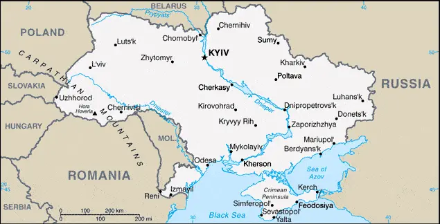
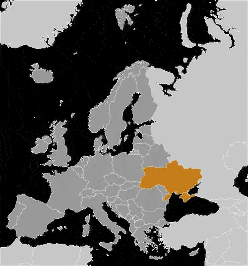
UKRAINE, formerly a Soviet socialist republic, declared itself inde­pendent of the former USSR in 1991. An eastern European country shares borders with Moldova, Hungary, Slovakia, Poland, Belarus, and Russia. Within Europe, it is surpassed in size only by Russia. The Crimean Peninsula in the south (Crimea), which borders the Black Sea and the Sea of Azov, has been an autonomous region within Ukraine between 1996-2014. Russian forces seized Crimea by force in 2014. Russia then annexed Crimea in 2014 following a referendum, administers it as two federal subjects of Russia, and claimed it to be “fully integrated” in July 2015.

Read more

Google Maps™ driving directions home » Europe maps

Ukraine Google Map

This image shows the draft map of Ukraine, Europe. For more details of the map of Ukraine, please see this page below. This image shows the location of Ukraine, Europe. For more geographical details of Ukraine, please see this page below. This image shows the flag of Ukraine, Europe. For more details of the flag of Ukraine, please see this page below.
Borderline map of Ukraine Location map of Ukraine Flag of Ukraine

Ukraine Google map

Google Maps and Detailed Facts of Ukraine (UA). This page lets you explore Ukraine and its border countries (Country Location: Eastern Europe, bordering the Black Sea, between Poland, Romania, and Moldova in the west and Russia in the east) through detailed Satellite imagery – fast and easy as never before Google Maps.

Find comprehensive information about this country’s diversity below: Google maps, geography, economy, science, people, culture, environment, government, and history – All in One Wiki page.

There is also a Street View and free Driving Directions at your service. Your Google Satellite Map Sightseeing in Ukraine, in Europe, starts here at Driving Directions and Maps.com.

Read more

Google Maps™ driving directions home » Europe maps

Vaduz Google maps

Vaduz is one of the most populated cities in Liechtenstein, and at the same time, this city is the capital of this country. Located in Europe, you may find the city easily with the following GPS coordinates: 47.08N latitude / 09.31E longitude. For routing in Vaduz, please check the free driving directions Vaduz service below.

Read more

Google Maps™ driving directions home » Europe maps

Valletta Google maps

Valletta is one of the most populated cities in Malta, and at the same time, this city is the capital of this country. Located in Europe, you may find the city easily with the following GPS coordinates: 35.54N latitude / 14.31E longitude. For routing in Valletta, please check the free driving directions Valletta service below.

Read more

Google Maps™ driving directions home » Europe maps

Vatican City Google Map

This image shows the draft map of Vatican City, Europe. For more details of the map of Vatican City, please see this page below. This image shows the location of Vatican City, Europe. For more geographical details of Vatican City, please see this page below. This image shows the flag of Vatican City, Europe. For more details of the flag of Vatican City, please see this page below.
Borderline map of Vatican City Location map of Vatican City Flag of Vatican City

Vatican City Google map

Google Maps and Detailed Facts of Vatican City (VT). This page lets you explore Vatican City and its border countries (Country Location: Southern Europe, an enclave of Rome (Italy)) through detailed Satellite imagery – fast and easy as never before Google Maps.

Find comprehensive information about this country’s diversity below: Google maps, geography, economy, science, people, culture, environment, government, and history – All in One Wiki page.

There is also a Street View and free Driving Directions at your service. Your Google Satellite Map Sightseeing in Vatican City, in Europe, starts here at Driving Directions and Maps.com.

Read more

Google Maps™ driving directions home » Europe maps

Vatican City Google maps

Vatican City is the most populated city in Vatican City, and at the same time, this city is the capital of this country, a city-state. Located in Europe, you may find the city easily with the following GPS coordinates: 41.90N latitude / 12.45E longitude. For routing in Vatican City, please check the free driving directions Vatican City service below.

Read more

Google Maps™ driving directions home » Europe maps

Vienna Google maps

Vienna is one of the most populated cities in Austria, and at the same time, this city is the capital of this country. Located in Europe, you may find the city easily with the following GPS coordinates: 48.12N latitude / 16.22E longitude. For routing in Vienna, please check the free driving directions Vienna service below.

Read more

Google Maps™ driving directions home » Europe maps

Vilnius Google maps

Vilnius is one of the most populated cities in Lithuania, and at the same time, this city is the capital of this country. Located in Europe, you may find the city easily with the following GPS coordinates: 54.38N latitude / 25.19E longitude. For routing in Vilnius, please check the free driving directions Vilnius service below.

Read more

Google Maps™ driving directions home » Europe maps

Warsaw Google maps

Warsaw is one of the most populated cities in Poland, and at the same time, this city is the capital of this country. Located in Europe, you may find the city easily with the following GPS coordinates: 52.13N latitude / 21.00E longitude. For routing in Warsaw, please check the free driving directions Warsaw service below.

Read more

Google Maps™ driving directions home » Europe maps

Zagreb Google maps

Zagreb is one of the most populated cities in Croatia, and at the same time, this city is the capital of this country. Located in Europe, you may easily find the city with the following GPS coordinates: 45.50N latitude / 15.58E longitude. For routing in Zagreb, please check the free driving directions Zagreb service below.

Read more