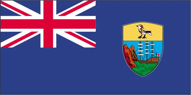
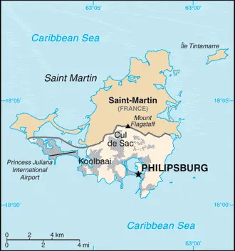
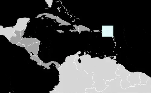
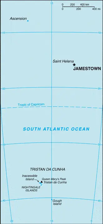
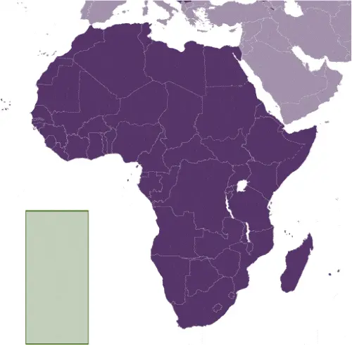
Google Maps™ Driving Directions (Home) » location » Page 4

Saint Helena Google Maps

This image shows the draft map of Saint Helena, Africa. For more details of the map of Saint Helena, please see this page below. This image shows the location of Saint Helena, Africa. For more geographical details of Saint Helena, please see this page below. This image shows the flag of Saint Helena, Africa. For more details of the flag of Saint Helena, please see this page below.
Borderline map of Saint Helena Location map of Saint Helena Flag of Saint Helena

Saint Helena Google Maps

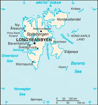
Google Maps and Detailed Facts of Saint Helena (SH). This page lets you explore Saint Helena and its border countries (Country Location: islands in the South Atlantic Ocean, about midway between South America and Africa; Ascension Island lies 1,300 km (800 mi) northwest of Saint Helena; Tristan da Cunha lies 4,300 km (2,700 mi) southwest of Saint Helena) through detailed Satellite imagery – fast and easy as never before Google Maps.

Find comprehensive information about this country’s diversity below: Google Maps, geography, economy, science, people, culture, environment, government, and history – All in One Wiki page.

There is also a Street View and free Driving Directions at your service. Your Google Satellite Map Sightseeing in Saint Helena, in Africa, starts here at Driving Directions and Maps.com.

Read more

Google Maps™ Driving Directions (Home) » location » Page 4

Sint Maarten Google Maps

This image shows the draft map of Sint Maarten, Central America, and the Caribbean. For more details of the map of Sint Maarten, please see this page below. This image shows the location of Sint Maarten, Central America, and the Caribbean. For more geographical details of Sint Maarten, please see this page below. This image shows the flag of Sint Maarten, Central America, and the Caribbean. For more details of the flag of Sint Maarten, please see this page below.
Borderline map of Sint Maarten Location map of Sint Maarten Flag of Sint Maarten

Sint Maarten Google Maps

Google Maps and Detailed Facts of Sint Maarten (SX). This page lets you explore Sint Maarten and its border countries (Country Location: the Caribbean, located in the Leeward Islands (northern) group; Dutch part of the island of Saint Martin in the Caribbean Sea; Sint Maarten lies east of the US Virgin Islands) through detailed Satellite imagery – fast and easy as never before Google Maps.

Find comprehensive information about this country’s diversity below: Google Maps, geography, economy, science, people, culture, environment, government, and history – All in One Wiki page.

There is also a Street View and free Driving Directions at your service. Your Google Satellite Map Sightseeing in Sint Maarten, in Central America, and the Caribbean, starts here at Driving Directions and Maps.com.

Read more

Google Maps™ Driving Directions (Home) » location » Page 4

Sierra Leone Google Maps

This image shows the draft map of Sierra Leone, Africa. For more details of the map of Sierra Leone, please see this page below. This image shows the location of Sierra Leone, Africa. For more geographical details of Sierra Leone, please see this page below. This image shows the flag of Sierra Leone, Africa. For more details of the flag of Sierra Leone, please see this page below.
Borderline map of Sierra Leone Location map of Sierra Leone Flag of Sierra Leone

Sierra Leone Google Maps

Google Maps and Detailed Facts of Sierra Leone (SL). This page lets you explore Sierra Leone and its border countries (Country Location: Western Africa, bordering the North Atlantic Ocean, between Guinea and Liberia) through detailed Satellite imagery – fast and easy as never before Google Maps.

Find comprehensive information about this country’s diversity below: Google Maps, geography, economy, science, people, culture, environment, government, and history – All in One Wiki page.

There is also a Street View and free Driving Directions at your service. In Africa, your Google Satellite Map Sightseeing in Sierra Leone starts here at Driving Directions and Maps.com.

Read more

Google Maps™ Driving Directions (Home) » location » Page 4

Somalia Google Maps

This image shows the draft map of Somalia, Africa. For more details of the map of Somalia, please see this page below. This image shows the location of Somalia, Africa. For more geographical details of Somalia, please see this page below. This image shows the flag of Somalia, Africa. For more details of the flag of Somalia, please see this page below.
Borderline map of Somalia Location map of Somalia Flag of Somalia

Somalia Google Maps

Google Maps and Detailed Facts of Somalia (SO). This page lets you explore Somalia and its border countries (Country Location: Eastern Africa, bordering the Gulf of Aden and the Indian Ocean, east of Ethiopia) through detailed Satellite imagery – fast and easy as never before Google Maps.

Find comprehensive information about this country’s diversity below: Google Maps, geography, economy, science, people, culture, environment, government, and history – All in One Wiki page.

There is also a Street View and free Driving Directions at your service. Your Google Satellite Map Sightseeing in Somalia, in Africa, starts here at Driving Directions and Maps.com.

Read more

Google Maps™ Driving Directions (Home) » location » Page 4

Sudan Google Maps

This image shows the draft map of Sudan, Africa. For more details of the map of Sudan, please see this page below. This image shows the location of Sudan, Africa. For more geographical details of Sudan, please see this page below. This image shows the flag of Sudan, Africa. For more details of the flag of Sudan, please see this page below.
Borderline map of Sudan Location map of Sudan Flag of Sudan

Sudan Google Maps

Google Maps and Detailed Facts of Sudan (SD). This page lets you explore Sudan and its border countries (Country Location: north-eastern Africa, bordering the Red Sea, between Egypt and Eritrea) through detailed Satellite imagery – fast and easy as never before Google Maps.

Find comprehensive information about this country’s diversity below: Google Maps, geography, economy, science, people, culture, environment, government, and history – All in One Wiki page.

There is also a Street View and free Driving Directions at your service. Your Google Satellite Map Sightseeing in Sudan, in Africa, starts here at Driving Directions and Maps.com.

Read more

Google Maps™ Driving Directions (Home) » location » Page 4

Svalbard Google Maps

This image shows the draft map of Svalbard, Arctic Region. For more details of the map of Svalbard, please see this page below. This image shows the location of Svalbard, Arctic Region. For more geographical details of Svalbard, please see this page below. This image shows the flag of Svalbard, Arctic Region. For more details of the flag of Svalbard, please see this page below.
Borderline map of Svalbard Location map of Svalbard Flag of Svalbard

Svalbard Google Maps

Google Maps and Detailed Facts of Svalbard (SV). This page lets you explore Svalbard and its border countries (Country Location: Northern Europe, islands between the Arctic Ocean, Barents Sea, Greenland Sea, and the Norwegian Sea, north of Norway) through detailed Satellite imagery – fast and easy as never before Google Maps.

Find comprehensive information about this country’s diversity below: Google Maps, geography, economy, science, people, culture, environment, government, and history – All in One Wiki page.

There is also a Street View and free Driving Directions at your service. Your Google Satellite Map Sightseeing in Svalbard, in Arctic Region, starts here at Driving Directions and Maps.com.

Read more

Google Maps™ Driving Directions (Home) » location » Page 4

Syria Google Maps

This image shows the draft map of Syria, Middle East. For more details of the map of Syria, please see this page below. This image shows the location of Syria, Middle East. For more geographical details of Syria, please see this page below. This image shows the flag of Syria, Middle East. For more details of the flag of Syria, please see this page below.
Borderline map of Syria Location map of Syria Flag of Syria

Syria Google Maps

Google Maps and Detailed Facts of Syria (SY). This page lets you explore Syria and its border countries (Country Location: the Middle East, bordering the Mediterranean Sea, between Lebanon and Turkey) through detailed Satellite imagery – fast and easy as never before Google Maps.

Find comprehensive information about this country’s diversity below: Google Maps, geography, economy, science, people, culture, environment, government, and history – All in One Wiki page.

There is also a Street View and free Driving Directions at your service. Your Google Satellite Map Sightseeing in Syria starts here at Driving Directions and Maps.com in the Middle East.

Read more

Google Maps™ Driving Directions (Home) » location » Page 4

Saint Barthelemy Google Maps

This image shows the draft map of Saint Barthelemy, Central America, and the Caribbean. For more details of the map of Saint Barthelemy, please see this page below. This image shows the location of Saint Barthelemy, Central America, and the Caribbean. For more geographical details of Saint Barthelemy, please see this page below. This image shows the flag of Saint Barthelemy, Central America, and the Caribbean. For more details of the flag of Saint Barthelemy, please see this page below.
Borderline map of Saint Barthelemy Location map of Saint Barthelemy Flag of Saint Barthelemy

Saint Barthelemy Google Maps

Google Maps and Detailed Facts of Saint Barthelemy (BL). This page lets you explore Saint Barthelemy and its border countries (Country Location: the Caribbean, island between the Caribbean Sea and the North Atlantic Ocean; located in the Leeward Islands (northern) group; Saint Barthelemy lies east of the US Virgin Islands) through detailed Satellite imagery – fast and easy as never before Google Maps.

Find comprehensive information about this country’s diversity below: Google Maps, geography, economy, science, people, culture, environment, government, and history – All in One Wiki page.

There is also a Street View and free Driving Directions at your service. Your Google Satellite Map Sightseeing in Saint Barthelemy, in Central America, and the Caribbean, starts here at Driving Directions and Maps.com.

Read more

Google Maps™ Driving Directions (Home) » location » Page 4

Trinidad and Tobago Google Maps

This image shows the draft map of Trinidad and Tobago, Central America, and the Caribbean. For more details of the map of Trinidad and Tobago, please see this page below. This image shows the location of Trinidad and Tobago, Central America, and the Caribbean. For more geographical details of Trinidad and Tobago, please see this page below. This image shows the flag of Trinidad and Tobago, Central America, and the Caribbean. For more details of the flag of Trinidad and Tobago, please see this page below.
Borderline map of Trinidad and Tobago Location map of Trinidad and Tobago Flag of Trinidad and Tobago

Trinidad and Tobago Google Maps

Google Maps and Detailed Facts of Trinidad and Tobago (TT). This page lets you explore Trinidad and Tobago and its border countries (Country Location: the Caribbean, islands between the Caribbean Sea and the North Atlantic Ocean, northeast of Venezuela) through detailed Satellite imagery – fast and easy as never before Google Maps.

Find comprehensive information about this country’s diversity below: Google Maps, geography, economy, science, people, culture, environment, government, and history – All in One Wiki page.

There is also a Street View and free Driving Directions at your service. Your Google Satellite Map Sightseeing in Trinidad and Tobago, in Central America, and the Caribbean, starts here at Driving Directions and Maps.com.

Read more

Google Maps™ Driving Directions (Home) » location » Page 4

Rwanda Google Maps

This image shows the draft map of Rwanda, Africa. For more details of the map of Rwanda, please see this page below. This image shows the location of Rwanda, Africa. For more geographical details of Rwanda, please see this page below. This image shows the flag of Rwanda, Africa. For more details of the flag of Rwanda, please see this page below.
Borderline map of Rwanda Location map of Rwanda Flag of Rwanda

Rwanda Google Maps

Google Maps and Detailed Facts of Rwanda (RW). This page lets you explore Rwanda and its border countries (Country Location: Central Africa, east of the Democratic Republic of the Congo, north of Burundi) through detailed Satellite imagery – fast and easy as never before Google Maps.

Find comprehensive information about this country’s diversity below: Google Maps, geography, economy, science, people, culture, environment, government, and history – All in One Wiki page.

There is also a Street View and free Driving Directions at your service. Your Google Satellite Map Sightseeing in Rwanda, in Africa, starts here at Driving Directions and Maps.com.

Read more