
 |
 |
 |
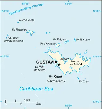
| Borderline map of Saint Barthelemy | Location map of Saint Barthelemy | Flag of Saint Barthelemy |
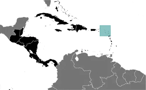
Google Maps and Detailed Facts of Saint Barthelemy (BL). This page lets you explore Saint Barthelemy and its border countries (Country Location: the Caribbean, island between the Caribbean Sea and the North Atlantic Ocean; located in the Leeward Islands (northern) group; Saint Barthelemy lies east of the US Virgin Islands) through detailed Satellite imagery – fast and easy as never before Google Maps.
Find comprehensive information about this country’s diversity below: Google Maps, geography, economy, science, people, culture, environment, government, and history – All in One Wiki page.
There is also a Street View and free Driving Directions at your service. Your Google Satellite Map Sightseeing in Saint Barthelemy, in Central America, and the Caribbean, starts here at Driving Directions and Maps.com.
Saint Barthelemy Google Maps & Satellite Maps
The map below shows Saint Barthelemy with its cities, towns, highways, main roads, streets, and Street Views. To find a location, use the form below, type any city or place, view a simple map, and click the “show map” button.
The Google Maps above shows Saint Barthelemy with its location: Central America, and the Caribbean (geographic coordinates: 17 90 N, 62 85 W) and the international borders of Saint Barthelemy; 0 km; furthermore, it’s inland counties boundaries.
Hint: Look at the Street view in Saint Barthelemy, or Central America, and the Caribbean. All you have to do is drag and pull the little yellow man (named: Pegman) on the Google Maps above the desired location. After that, whenever it is available (more than 50 countries globally), blue stripes will appear to show the photos and details from Google’s regularly updated data image base. In case if you have signed in to your Google account currently, you may have a look at the satellite map of this country/area as well.
The map of Saint Barthelemy, Central America, and the Caribbean is for informational use only. No representation is made or warrantied given any map or its content by Driving Directions and Maps site. The user assumes all risks of using this Saint Barthelemy Google Maps and facts/wiki.
About Saint Barthelemy in detail
Where is Saint Barthelemy?
Saint Barthelemy, in case, if you are looking on the map under the Coordinates 17 53 N 62 51 W otherwise in Central America, and the Caribbean, in the Caribbean, island between the Caribbean Sea and the North Atlantic Ocean; located in the Leeward Islands (northern) group; Saint Barthelemy lies east of the US Virgin Islands.
What is the capital city of Saint Barthelemy?
The capital city of Saint Barthelemy is Gustavia.
What is the time in Gustavia?
It is 1 hour ahead of Washington, D.C. during Standard Time; the timezone of Gustavia is UTC-4.
What is the Internet code for Saint Barthelemy?
The Top Level Domain (TLD) for Saint Barthelemy is: .bl
What is the size of Saint Barthelemy?
The territory of Saint Barthelemy is total: 25 sq km; land: 25 sq km, water: NEGL.
If we want to describe the size of Saint Barthelemy’s territory is less than one-eighth the size of Washington, DC.
If we would like to walk around and discover Saint Barthelemy, we can cover a distance of 0 km.
What is the water coverage of Saint Barthelemy?
We have already mentioned what percentage of Saint Barthelemy is covered by water (see below), including the N/A coastline.
What is the climate like in Saint Barthelemy?
The climate of Saint Barthelemy is tropical, with practically no temperature variation: it has two seasons (dry and humid).
Geographical data of Saint Barthelemy
The elevation of Saint Barthelemy; mean elevation: N/A, elevation extremes; lowest point: Caribbean Ocean 0 m, highest point: Morne du Vitet 286 m.
The specific geographical details of Saint Barthelemy include hilly, almost surrounded by shallow-water reefs, with plentiful beaches.
Suppose we would like to describe the countries location from a different perspective. In that case, it is safe to say, and easy to read from a map, Saint Barthelemy is a 1,200-hectare marine nature reserve, the Reserve Naturelle, is made up of five zones around the island that form a network to protect the island’s coral reefs, seagrass, and endangered marine species.
Resources and land use of Saint Barthelemy
The country’s main mined products are few natural resources; beaches foster tourism. The population partly uses the earlier highlighted land territory and partly left in its natural state: N/A.
Population data of Saint Barthelemy
The number of inhabitants of Saint Barthelemy is 7,209 (July 2016 estimate).
Let’s examine the proportion of the population distribution. It is safe to say that most of the populace concentrated in and around the capital of Gustavia, but scattered settlements exist around the island periphery.
If we look at the proportion of the urbanized and barely populated areas, these are the figures: N/A.
Most of the population in Saint Barthelemy is concentrated in N/A.
Ethnicity in Saint Barthelemy
According to ethnicity details, the ethnic groups are white, Creole (mulatto), black, Guadeloupe Mestizo (French-East Asia).
Spoken languages in Saint Barthelemy
The spoken languages in Saint Barthelemy are the following: French (primary), English.
What are the most important religions in Saint Barthelemy?
During the general census, researchers examine the churches, according to this: Roman Catholic, Protestant, Jehovah’s Witnesses.
Further population data of Saint Barthelemy
The proportion of gender and age tells a lot about the society as follows 0-14 years: 16.9% (male 626 / female 592) 15-24 years: 7.09% (male 268 / female 243) 25-54 years: 44.57% (male 1,748 / female 1,465) 55-64 years: 15.52% (male 607 / female 512) 65 years and over: 15.92% (male 575 / female 573) (2016 estimate). It also a significant factor in a society the population growth rate, which in the case of Saint Barthelemy is N/A.
The population growth rate is based on two elements, the birth, and the death rate. In Saint Barthelemy, the birth rate is N/A, the death rate N/A.
In this day and age in developed societies, the first child borns later compared to the previous centuries and decades, so childbearing is extended. In Saint Barthelemy, the average age of mothers at the first childbirth is N/A.
Although the children’s birth is postponed in the best-case scenario, the parents can still see their kids grow as life expectancy also extended. In the case of Saint Barthelemy, these figures are. With the introduction of modern medicine, vaccinations, and the proper hygienic conditions, the infant mortality rate is in a steep decline. The infant mortality statistics in Saint Barthelemy are the following: N/A. Relevant data is the budget of healthcare, which is in the case of this country is N/A.
Economic data of Saint Barthelemy
Suppose we would like to describe a country. We also have to mention its economy; Saint Barthelemy’s economy is based upon high-end tourism and duty-free luxury commerce, serving visitors primarily from North America. The luxury hotels and villas host 70,000 visitors each year, with another 130,000 arriving by boat. The relative is.
GDP is a prominent figure, as all the relevant calculations and statistics are based on it. GDP in Saint Barthelemy is N/A.
Another important indicator is the rate of GDP growth, which in Saint Barthelemy is N/A.
These statistics affect the world economy; remember, in 2015, the Chinese real GDP growth rate was worse than expected; The world markets fall, and the Chinese stock exchange was temporarily suspended.
A further major factor of a country’s economy, the GDP per capita. In Saint Barthelemy, this is N/A.
In the economy, the Trinity is in common places, such as agriculture, industry, and services.
What are the agricultural products Saint Barthelemy produces?
The main agricultural products of Saint Barthelemy are N/A.
Regarding the economy, the important segments are N/A. The crucial and regularly mentioned GDP is based on N/A.
Drinking water source in Saint Barthelemy
It is essential to mention that – thanks to the infrastructure development– the rate of potable water N/A.
The average number of childbirth in Saint Barthelemy
In Saint Barthelemy, the average delivery number is N/A.
Population, median age, migration, and citizenship in Saint Barthelemy
The population’s average age is 43.6 years; male: 43.5 years, female: 43.6 years (2016 estimate). The age of adulthood varies in every country of the world in Saint Barthelemy; it is 18 years of age, universal.
When we are experiencing an unprecedented scale of migration and globalization, it is an important factor in the number of new immigrants. In Saint Barthelemy is N/A. It is vital to know how to apply for citizenship: see France.
Is Saint Barthelemy a safe destination? Healthcare services and infectious diseases in Saint Barthelemy
Many of the travelers are looking into the healthcare services and infectious diseases of their destinations. In Saint Barthelemy, the hospital beds’ density is N/A.
According to the WHO rating regarding contagious diseases in Saint Barthelemy the note: active local transmission of Zika virus by Aedes species mosquitoes has been identified in this country (as of August 2016); it poses an important risk (a large number of cases possible) among US citizens if bitten by an infective mosquito; other less common ways to get Zika are through sex, via blood transfusion, or during pregnancy, in which the pregnant woman passes Zika virus to her fetus (2016).
However, HIV is not curable but maintainable. Let’s do not forget when the disease surfaced; it was a world threatening condition. Unfortunately, in some countries, it is still very high the number of infected patients and fatalities due to the disease.
In Saint Barthelemy, the number of HIV/AIDS deaths: N/A.
Regarding tourism obesity, not an important issue, but we have to mention health statistics, as it is the plague of the 20th and the 21st century. The rate of obese adults in Saint Barthelemy is N/A.
What are the natural hazards in Saint Barthelemy? Is there any?
The most known natural risk in Saint Barthelemy is N/A.
More interesting facts about Saint Barthelemy
A few words about the past, as every country and society, is connected to its history; Discovered in 1493 by Christopher COLUMBUS, who named it for his brother Bartolomeo, Saint Barthelemy was first settled by the French in 1648. In 1784, the French sold the island to Sweden, which was renamed the largest town, Gustavia, after the Swedish King GUSTAV III, and made it a free port; the island prospered as a trade and supply center during the colonial wars of the 18th century. France repurchased the island in 1877 and took control the following year. It was placed under the administration of Guadeloupe. Saint Barthelemy retained its free port status and various Swedish appellations such as Swedish street and town names and the three-crown symbol on the coat of arms. In 2003 the islanders voted to secede from Guadeloupe, and in 2007 the island became a French overseas collectivity. In 2012, it became an overseas territory of the EU, allowing it to exert local control over foreign workers’ permanent and temporary immigration, including non-French European citizens.
In every nation’s memory, some cornerstones placed the country on the timeline of history. The date of declaration of independence of Saint Barthelemy: N/A.
The flag and other symbols of Saint Barthelemy
The colors, symbols, and animals on the flag usually have a historical background or an important milestone or memory of the nation.
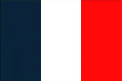
This case is not an exception either; the flag of France is used.
Apart from the flag, the symbol of national unity is the national anthem. The anthem’s primary purpose is to share the nation’s core values, endeavors, and patriotic feelings.
National symbols of Saint Barthelemy: pelican.
Constitution of Saint Barthelemy
The existence of the nation is based on the constitution. Some constitutions knew worldwide, like the U.S. Constitution that was accepted on the 17th of September 1787, in Philadelphia, the United States of America’s Constitution.
It is not related to the declaration of independence that was stolen by Nicolas Cage in the movie National Treasure 🙂
What is the legal system of Saint Barthelemy?
Most of the time, the legal system of a country is the focus of lawyers. It is a common fact that there are two main approaches in the world, “the law in books” and “the law in action.”
In the Anglo-Saxon world, the practice is the “law in action,” while in the rest of the world, the law is based on Roman law, the “law in books.”
The legal system of Saint Barthelemy is French civil law.
It was Aristotle who founded the Theory of 3 separations of powers. In his view, these are the council of public affairs, the magistrates, and the justice system. The age of enlightenment was the time when terminologies have defined the way we still use them. In most democratic countries, the three authorities separated from each other. In dictatorships, the rules usually interweaved in one hand.
About the legislative branch of Saint Barthelemy, we can highlight the following structures unicameral Territorial Council (19 seats; members elected by absolute majority vote in the first round vote and proportional representation vote in the second round; members serve 5-year terms). Note: Saint Barthelemy holds one seat in the French Senate. Saint Barthelemy elects one seat to the French National Assembly.
About the unemployment rate, labor force, and poverty line in Saint Barthelemy
One of the major problems of the 21st-century economy is unemployment. Governments are struggling to maintain a low level of the unemployment rate. Still, as a result of automation, the cheap 3rd world labor, and the outsourcing of workflow, these attempts fail. In Saint Barthelemy, the labor force is N/A. Please bear in mind that the population in Saint Barthelemy is total: N/A, male: N/A, female: N/A – as we already mentioned above.
The rate of unemployment in Saint Barthelemy is N/A.
Widely known that the gap between the rich and poor is widening on an enormous scale.
According to the 2017 shocking Oxfam report, the most affluent eight people’s fortune is equal to the wealth of the poorest half of the world’s population.
In Saint Barthelemy, the households’ income and consumption compared to the entire population: N/A.
Another widely used indicator is the so-called GINI index, which measures the inequalities of statistical dispersion, but is mainly used for measuring the sharing of income and fortune.
The GINI index was named after its founder Corrado Gini, an Italian economist. Gini index has grades between 0-1, but often it is used on a percentage basis. It is 0 if the examined criteria territorial distribution is equal. It is one of the criteria concentrated on the territory. In Saint Barthelemy, the GINI index is N/A.
The states usually set up a poverty line, which is more or less, is a subjective measure. It varies by country; its base is often the minimum pension, the incomes of the most deficient 20 percent, the X percent of income per capita Etc.
In Saint Barthelemy, the number of people living under the poverty line is N/A.
About the budget and central governments debt of Saint Barthelemy
The available budget mainly defines the state’s economy. The budget of Saint Barthelemy is; N/A. Taxes and other revenues are N/A.
The budget deficit (Budget surplus (+) or deficit (-)) is N/A.
The fiscal year in Saint Barthelemy is N/A.
In the country’s economy, we have to consider the public debt. Public debt is the consolidated sum of the state’s local, federal, and central government debt.
Inflation rate and prime lending rate in Saint Barthelemy
A few further interesting and relevant economic data are the following; Inflation rate: N/A, and the commercial bank prime lending rate: N/A.
Export/import partners and data of Saint Barthelemy
Saint Barthelemy, with the export of products, industrial tools, and other services, generates revenue. The export value in Saint Barthelemy is N/A. The total revenue of these activities: N/A.
The most important export partners of Saint Barthelemy are N/A.
The most important imported products are N/A, and the countries where the import is coming: N/A.
Renewable energies used in Saint Barthelemy
To suppress the pollution of the environment, renewable energies have to replace the fossil energy. The more the proportion of renewable energies in a country means more effort against pollution. Saint Barthelemy, the indicator of how much of the country’s produced energy is coming from the hydroelectric source, is N/A.
To indicate how much another renewable energy produced is N/A.
Telecommunication data of Saint Barthelemy, calling code
To maintain the economy, the development of a reliable and modern telecommunications infrastructure is crucial. We can say the following about Saint Barthelemy; fully integrated access. Domestic: direct-dial capability with both fixed and wireless systems international: country code – 590; undersea fiber-optic cable provides voice and data connectivity to Puerto Rico and Guadeloupe (2008).
Transport infrastructure in Saint Barthelemy
In the 21st century, we often say that the world has become small and there are no distances anymore. With widespread air travel when (sometimes) there are no visa restrictions, it is easy to reach other countries, but if the distance is not too long, we can also use railway or water transportation.
The number of airports in Saint Barthelemy: 1 (2013), and the number of heliports: N/A.
The total length of the roadways in Saint Barthelemy: N/A.
The total length of the waterways in Saint Barthelemy: N/A.
Are you traveling to Saint Barthelemy?
If you plan to travel by plane to Saint Barthelemy, try our air ticket comparison site, where you can choose from hundreds of carriers and offers. Our application is scanning the market and shows you the best and the cheapest deals without any extra charge or commission.
Are you looking for a hotel, apartment another kind of accommodation in Saint Barthelemy, Central America, and the Caribbean? We are here to help you to find your accommodation from budget to luxury. Our search engine is scanning, regularly updating data from hundreds of accommodation websites and more than a million offers. You can quickly and easily find your hotel stay anywhere in the world, without any extra charge or commission.
Facts & data about Saint Barthelemy
Name of the country: conventional long way: Overseas Collectivity of Saint Barthelemy, traditional short form: Saint Barthelemy, local long form: Collectivite d’outre merde Saint-Barthelemy, local short state: Saint-Barthelemyabbreviation: Saint-Barth (French); St. Barts or St. Barths (English), etymology: explorer Christopher COLUMBUS named the island in honor of his brother Bartolomeo’s namesake saint in 1493.
| Abbreviation: Saint Barthelemy | Geographic coordinates: 17 90 N, 62 85 W |
Country Location: Central America and the Caribbean |
| Capital of Saint Barthelemy: Gustavia | GPS of the Capital: 17 53 N 62 51 W |
Position: the Caribbean, island between the Caribbean Sea and the North Atlantic Ocean; located in the Leeward Islands (northern) group; Saint Barthelemy lies east of the US Virgin Islands |
| Land area: total: 25 sq km; land: 25 sq km, water: NEGL | Terrain: hilly, almost surrounded by shallow-water reefs, with plentiful beaches |
Area comparative: less than one-eighth the size of Washington, DC |
| Population: 7,209 (July 2016 estimate) | Population growth rate: N/A | Sex ratio: at birth: 1.06 male(s) / female, 0-14 years: 1.06 male(s) / female, 15-24 years: 1.1 male(s) / female, 25-54 years: 1.19 male(s) / female, 55-64 years: 1.19 male(s) / female, 65 years and over: 1 male(s) / female, total population: 1.13 male(s) / female (2016 estimate) |
| Exports: N/A | Imports: N/A | Import partners: N/A |
| Urbanization: N/A | Major urban area(s): N/A | Median age: total: 43.6 years; male: 43.5 years, female: 43.6 years (2016 estimate) |
| Internet users: N/A | Telephones (fixed-lines): N/A | Telephones (mobile, cellular): N/A |
| Unemployment rate: N/A | Nationality: N/A | National holidays: Fete de la Federation, 14 July (1789) |
| Life expectancy at birth: N/A | Total fertility rate: N/A | Birthrate: N/A |
| Literacy: N/A | Legal system: French civil law | Suffrage: 18 years of age, universal |
| Industries: N/A | Industrial production growth rate: N/A | GDP real growth rate: N/A |
Do you like this Saint Barthelemy Google Maps & country information page?
Please do us a favor: Share or like this page using the icons at the top of the page. We also do encourage you to visit our Facebook page for more travel and country related information.
Many thanks for visiting and sharing this map & country information site!