
 |
 |
 |
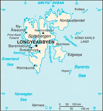
| Borderline map of Svalbard | Location map of Svalbard | Flag of Svalbard |
Google Maps and Detailed Facts of Svalbard (SV). This page lets you explore Svalbard and its border countries (Country Location: Northern Europe, islands between the Arctic Ocean, Barents Sea, Greenland Sea, and the Norwegian Sea, north of Norway) through detailed Satellite imagery – fast and easy as never before Google Maps.
Find comprehensive information about this country’s diversity below: Google Maps, geography, economy, science, people, culture, environment, government, and history – All in One Wiki page.
There is also a Street View and free Driving Directions at your service. Your Google Satellite Map Sightseeing in Svalbard, in Arctic Region, starts here at Driving Directions and Maps.com.
Svalbard Google Maps & Satellite Maps
The map below shows Svalbard with its cities, towns, highways, main roads, streets, and Street Views. To find a location, use the form below, type any city or place, view a simple map, and click the “show map” button.
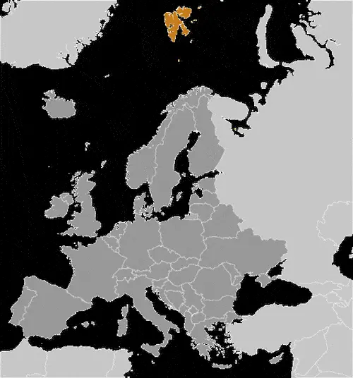
The Google Maps above shows Svalbard with its location: Arctic Region (geographic coordinates: 78 00 N, 20 00 E) and the international borders of Svalbard; 0 km; furthermore, it’s inland counties boundaries.
Hint: Look at the Street view in Svalbard, or Arctic Region. All you have to do is drag and pull the little yellow man (named: Pegman) on the Google Maps above the desired location. After that, whenever it is available (more than 50 countries globally), blue stripes will appear to show the photos and details from Google’s regularly updated data image base. In case if you have signed in to your Google account currently, you may have a look at the satellite map of this country/area as well.
The map of Svalbard, Arctic Region, is for informational use only. No representation is made or warrantied given any map or its content by Driving Directions and Maps site. The user assumes all risks of using this Svalbard Google Maps and facts/wiki.
About Svalbard in detail
Where is Svalbard?
Svalbard, in case, if you are looking on the map under the Coordinates 78 13 N 15 38 E otherwise in Arctic Region, in Northern Europe, islands between the Arctic Ocean, Barents Sea, Greenland Sea, and the Norwegian Sea, north of Norway.
What is the capital city of Svalbard?
The capital city of Svalbard is Longyearbyen.
What is the time in Longyearbyen?
It is 6 hours ahead of Washington, D.C. during Standard Time; the timezone of Longyearbyen is UTC+1.
What is the Internet code for Svalbard?
The Top Level Domain (TLD) for Svalbard is: .sj
What is the size of Svalbard?
The territory of Svalbard is total: 62,045 sq km; land: 62,045 sq km, water: 0 sq km.
If we want to describe the size of the territory of Svalbard is somewhat smaller than West Virginia.
If we would like to walk around and discover Svalbard, we can cover a distance of 0 km.
What is the water coverage of Svalbard?
We have already mentioned what percentage of Svalbard is covered by water (see below), and this includes 3,587 km coastline.
What is the climate like in Svalbard?
The climate of Svalbard is arctic, tempered by warm North Atlantic Current: cool summers, cold winters: North Atlantic Current flows along west and north coasts of Spitsbergen, keeping water open and navigable most of the year.
Geographical data of Svalbard
Svalbard elevation; mean elevation: N/A, elevation extremes; lowest point: Arctic Ocean 0 m, highest point: Newtontoppen 1,717 m.
The specific geographical details of Svalbard include rugged mountains; much of the upland areas are ice covered; west coast clear of ice about half the year; fjords along the west and north coasts.
Suppose we would like to describe the countries location from a different perspective. In that case, it is safe to say, and easy to read from a map, Svalbard is the northernmost part of the Kingdom of Norway; consists of nine main islands; glaciers and snowfields cover 60% of the total area; Spitsbergen Island is the site of the Svalbard Global Seed Vault, a seed repository established by the Global Crop Diversity Trust and the Norwegian Government.
Resources and land use of Svalbard
The country’s main mined products are coal, iron ore, copper, zinc, phosphate, wildlife, fish. The population partly uses the earlier highlighted land territory and partly left in its natural state: agricultural land: 0%; arable land 0%; permanent crops 0%; permanent pasture 0%; forest: 0%; other: 100% (2011 estimate).
Population data of Svalbard
The number of inhabitants of Svalbard is 1,872 (July 2014 estimate).
If we examine the proportion of the population distribution, it is safe to say that the small population is primarily concentrated on the island of Spitsbergen in a handful of settlements on the south side of the Isfjorden Longyearbyen being the largest.
If we look at the proportion of the urbanized and barely populated areas, these are the figures: N/A.
Most of the population in Svalbard is concentrated in N/A.
Ethnicity in Svalbard
According to ethnicity details, the ethnic groups are Norwegian 55.4%, Russian and Ukrainian 44.3%, other 0.3% (1998).
Spoken languages in Svalbard
The spoken languages in Svalbard are the following: Norwegian, Russian.
What are the most important religions in Svalbard?
During the general census, researchers examine the churches, according to this: N/A.
Further population data of Svalbard
The proportion of gender and age tells a lot about society as follows N/A. It also a significant factor in a society; the population growth rate, which in the case of Svalbard, is -0.03% (2014 estimate).
The population growth rate is based on two elements, the birth, and the death rate. In Svalbard, the birth rate is N/A, the death rate N/A.
In this day and age in developed societies, the first child borns later compared to the previous centuries and decades, so childbearing is extended. In Svalbard, the average age of mothers at the first childbirth is N/A.
Although the children’s birth is postponed in the best-case scenario, the parents can still see their kids grow as life expectancy also extended. In the case of Svalbard, these figures are. With the introduction of modern medicine, vaccinations, and the proper hygienic conditions, the infant mortality rate is in a steep decline. The infant mortality statistics in Svalbard are the following: N/A. Relevant data is the budget of healthcare, which is in the case of this country is N/A.
Economic data of Svalbard
Suppose we would like to describe a country, we also have to mention its economy; Tourism and international research are Svalbard’s major revenue sources. Coal mining has historically been the dominant economic activity, and a treaty of 9 February 1920 gave the 41 signatories equal rights to exploit mineral deposits. The settlements on Svalbard were established as company towns, and at their height in the 1950s, the Norwegian state-owned coal company supported around 1,000 jobs. Today, around 300 people work in the mining industry. Goods such as alcohol, tobacco, and vehicles, normally highly taxed on mainland Norway, are considerably cheaper in Svalbard than the Norwegian government to entice more people to live on the Arctic archipelago.
GDP is a prominent figure, as all the relevant calculations and statistics are based on it. GDP in Svalbard is N/A.
Another important indicator is the rate of GDP growth, which in Svalbard is N/A%.
In the economy, the Trinity is in common places, such as agriculture, industry, and services.
What are the agricultural products Svalbard produces?
The main agricultural products of Svalbard are N/A.
Regarding the economy, the essential segments are N/A. The crucial and regularly mentioned GDP is based on N/A.
Drinking water source in Svalbard
It is essential to mention that – thanks to the infrastructure development– the rate of potable water N/A.
The average number of childbirth in Svalbard
In Svalbard, the average delivery number is N/A.
Population, median age, migration, and citizenship in Svalbard
The average age of the population is N/A. The age of adulthood varies in every country of the world. In Svalbard, it is N/A.
When we are experiencing an unprecedented scale of migration and globalization, it is an important factor in the number of new immigrants. In Svalbard is N/A. It is important to know how to apply for citizenship: see Norway.
Is Svalbard a safe destination? Healthcare services and infectious diseases in Svalbard
Many of the travelers are looking into the healthcare services and infectious diseases of their destinations. In Svalbard, the hospital beds’ density is N/A.
According to the WHO rating regarding contagious diseases in Svalbard: N/A.
However, HIV is not curable but maintainable. Let’s do not forget when the disease surfaced; it was a world threatening condition. Unfortunately, in some countries, it is still very high the number of infected patients and fatalities due to the disease.
In Svalbard, the number of HIV/AIDS deaths: N/A.
Regarding tourism obesity, not an important issue, but we have to mention health statistics, as it is the plague of the 20th and the 21st century. The rate of obese adults in Svalbard is N/A.
What are the natural hazards in Svalbard? Is there any?
The most known natural risk in Svalbard is ice floes often block the entrance to Bellsund (a transit point for coal export) on the west coast and occasionally make parts of the northeastern coast inaccessible to maritime traffic.
More interesting facts about Svalbard
A few words about the past, as every country and society is connected to its history; Norse explorers may have first discovered the archipelago in the 12th century; the islands served as an international whaling base during the 17th and 18th centuries. The treaty internationally recognized Norway’s sovereignty in 1920, and five years later, it officially took over the territory. In the 20th-century, coal mining started, and today, a Norwegian and a Russian company are still functioning. Travel between the settlements is accomplished with snowmobiles, aircraft, and boats.
In every nation’s memory, some cornerstones placed the country on the timeline of history. The date of declaration of independence of Svalbard: none (territory of Norway).
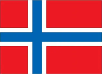
The flag and other symbols of Svalbard
The colors, symbols, and animals on the flag usually have a historical background or an important milestone or memory of the nation.
This case is not an exception either; the flag of Norway is used.
Apart from the flag, the symbol of national unity is the national anthem. The anthem’s primary purpose is to share the nation’s core values, endeavors, and patriotic feelings.
National symbols of Svalbard: N/A.
Constitution of Svalbard
The existence of the nation is based on the constitution. Some constitutions knew worldwide, like the U.S. Constitution that was accepted on the 17th of September 1787, in Philadelphia, the United States of America’s Constitution.
It is not related to the declaration of independence that was stolen by Nicolas Cage in the movie National Treasure 🙂
What is the legal system of Svalbard?
Most of the time, the legal system of a country is the focus of lawyers. It is a common fact that there are two main approaches in the world, “the law in books” and “the law in action.”
In the Anglo-Saxon world, the practice is the “law in action,” while in the rest of the world, the law is based on Roman law, the “law in books.”
The legal system of Svalbard is the laws of Norway where applicable apply; only the laws of Norway made explicitly applicable to Svalbard have an effect there; the Svalbard Act and the Svalbard Environmental Protection Act, and certain regulations, apply only to Svalbard; the Spitsbergen Treaty and the Svalbard Treaty grants certain rights to citizens and corporations of signatory nations.
It was Aristotle who founded the Theory of 3 separations of powers. In his view, these are the council of public affairs, the magistrates, and the justice system. The age of enlightenment was the time when terminologies have defined the way we still use them. In most democratic countries, the three authorities separated from each other. In dictatorships, the rules usually interweaved in one hand.
About the legislative branch of Svalbard, we can highlight the following structures unicameral Longyearbyen Community Council (15 seats; members elected by direct vote to serve four-year terms)elections: last held on 6 October 2015 (next to be held October 2019)election results: seats by party – Conservatives 5, Green Party 2, Labor Party 5, Liberals 3note: the Council’s main responsibilities are infrastructure and utilities, including power, land-use, and community planning, education, and child welfare; however, healthcare services are provided by the state.
About the unemployment rate, labor force, and poverty line in Svalbard
One of the major problems of the 21st-century economy is unemployment. Governments are struggling to maintain a low level of the unemployment rate. Still, as a result of automation, the cheap 3rd world labor, and the outsourcing of workflow, these attempts fail. In Svalbard, the labor force is 1,590 (2013). Please bear in mind that the population in Svalbard is total: N/A, male: N/A, female: N/A – as we already mentioned above.
The rate of unemployment in Svalbard is N/A.
Widely known that the gap between the rich and poor is widening on an enormous scale.
According to the 2017 shocking Oxfam report, the most affluent eight people’s fortune is equal to the wealth of the poorest half of the world’s population.
In Svalbard, the households’ income and consumption compared to the entire population: N/A.
Another widely used indicator is the so-called GINI index, which measures the inequalities of statistical dispersion, but is mainly used for measuring the sharing of income and fortune.
The GINI index was named after its founder Corrado Gini, an Italian economist. Gini index has grades between 0-1, but often it is used on a percentage basis. It is 0 if the examined criteria territorial distribution is equal. It is one of the criteria concentrated on the territory. In Svalbard, the GINI index is N/A.
The states usually set up a poverty line, which is more or less, is a subjective measure. It varies by country; its base is often the minimum pension, the incomes of the most deficient 20 percent, the X percent of income per capita Etc.
In Svalbard, the number of people living under the poverty line is N/A.
About the budget and central governments debt of Svalbard
The available budget mainly defines the state’s economy. The budget of Svalbard is; revenues: $ N/A, expenditures: $NA. Taxes and other revenues are N/A% of GDP.
The budget deficit (Budget surplus (+) or deficit (-)) is N/A.
The fiscal year in Svalbard is N/A.
In the country’s economy, we have to consider the public debt. Public debt is the consolidated sum of the state’s local, federal, and central government debt.
Inflation rate and prime lending rate in Svalbard
A few further interesting and relevant economic data are the following; Inflation rate: N/A, and the commercial bank prime lending rate: N/A.
Export/import partners and data of Svalbard
Svalbard, with the export of products, industrial tools, and other services, generates revenue. The export value in Svalbard is N/A. The total revenue of these activities: N/A.
The most important export partners of Svalbard are N/A.
The most important imported products are N/A, and the countries where the import is coming: N/A.
Renewable energies used in Svalbard
To suppress the pollution of the environment, renewable energies have to replace the fossil energy. The more the proportion of renewable energies in a country means more effort against pollution. Svalbard, the indicator of how much of the country’s produced energy is coming from the hydroelectric source, is N/A.
To indicate how much another renewable energy produced is N/A.
Telecommunication data of Svalbard, calling code
To maintain the economy, the development of a reliable and modern telecommunications infrastructure is crucial. We can say the following about Svalbard; adequate. Domestic: local telephone service. International: country code – 47-790; satellite earth station – 1 of unknown type (for communication with Norwegian mainland only) (2005).
Transport infrastructure in Svalbard
In the 21st century, we often say that the world has become small and there are no distances anymore. With widespread air travel when (sometimes) there are no visa restrictions, it is easy to reach other countries, but if the distance is not too long, we can also use railway or water transportation.
The number of airports in Svalbard: 4 (2013), and the number of heliports: 1 (2013).
The total length of the roadways in Svalbard: N/A.
The total length of the waterways in Svalbard: N/A.
Are you traveling to Svalbard?
If you plan to travel by plane to Svalbard, try our air ticket comparison site, where you can choose from hundreds of carriers and offers. Our application is scanning the market and shows you the best and the cheapest deals without any extra charge or commission.
Are you looking for a hotel, apartment another kind of accommodation in Svalbard, Arctic Region? We are here to help you to find your accommodation from budget to luxury. Our search engine is scanning, regularly updating data from hundreds of accommodation websites and more than a million offers. You can quickly and easily find your hotel stay anywhere in the world, without any extra charge or commission.
Facts & data about Svalbard
Name of the country: conventional long way: none, traditional short form: Svalbard (sometimes referred to as Spitsbergen, the largest island in the archipelago), etymology: 12th-century Norse accounts speak of the discovery of a “Svalbard” – literally “cold shores” – but they may have referred to Jan Mayen island or eastern Greenland; the archipelago was traditionally known as Spitsbergen, but Norway renamed it Svalbard in the 1920s when it assumed sovereignty of the islands.
| Abbreviation: Svalbard | Geographic coordinates: 78 00 N, 20 00 E |
Country Location: Arctic Region |
| Capital of Svalbard: Longyearbyen | GPS of the Capital: 78 13 N 15 38 E |
Position: Northern Europe, islands between the Arctic Ocean, Barents Sea, Greenland Sea, and the Norwegian Sea, north of Norway |
| Land area: total: 62,045 sq km; land: 62,045 sq km, water: 0 sq km | Terrain: rugged mountains; much of the upland areas are ice covered; west coast clear of ice about half the year; fjords along the west and north coasts |
Area comparative: somewhat smaller than West Virginia |
| Population: 1,872 (July 2014 estimate) | Population grow rate: -0.03% (2014 estimate) | Sex ratio: N/A |
| Exports: $ N/A | Imports: $NA | Import partners: N/A |
| Urbanization: N/A | Major urban area(s): N/A | Median age: N/A |
| Internet users: N/A | Telephones (fixed-lines): N/A | Telephones (mobile, cellular): N/A |
| Unemployment rate: N/A | Nationality: N/A | National holidays: N/A |
| Life expectancy at birth: total population: N/A. Male: N/A, female: N/A | Total fertility rate: N/A | Birthrate: N/A |
| Literacy: N/A | Legal system: the laws of Norway where applicable apply; only the laws of Norway made explicitly applicable to Svalbard have an effect there; the Svalbard Act and the Svalbard Environmental Protection Act, and certain regulations, apply only to Svalbard; the Spitsbergen Treaty and the Svalbard Treaty grants certain rights to citizens and corporations of signatory nations | Suffrage: N/A |
| Industries: N/A | Industrial production growth rate: N/A | GDP real growth rate: N/A% |
Do you like this Svalbard Google Maps & country information page?
Please do us a favor: Share or like this page using the icons at the top of the page. We also do encourage you to visit our Facebook page for more travel and country related information.
Many thanks for visiting and sharing this map & country information site!