Google Maps™ driving directions home » Trinidad and Tobago

Trinidad and Tobago

Driving Directions Trinidad and Tobago

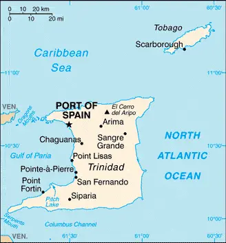
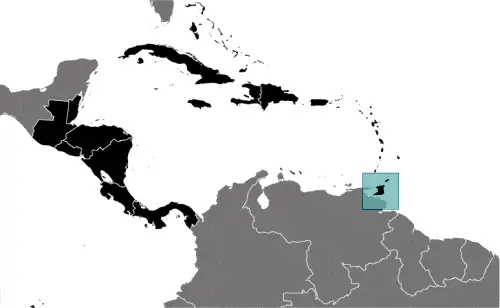
TRINIDAD AND TOBAGO form the third-largest British Commonwealth country in the West Indies. The islands, situated off the Orinoco Delta in northeastern Venezuela, are the most southerly of the Lesser Antilles group.

Trinidad consists of a mountain range in the north and undulating plains in the south. It has a vast, asphalt-producing lake, Pitch Lake, approximately 42 hectares or 104 acres in size. Tobago is a mountain that is about 550 meters or 1,800 feet above sea level at its peak.

Read more

Google Maps™ driving directions home » Trinidad and Tobago

Port of Spain Google maps

Port of Spain is one of the most populated cities in Trinidad and Tobago, and at the same time, this city is the capital of this country. Located in America, you may find the city easily with the following GPS coordinates: 10.64N latitude / 61.51W longitude. For routing in Port of Spain, please check the free driving directions Port of Spain service below.

Read more

Google Maps™ driving directions home » Trinidad and Tobago

The most Googled products in each country in North America

Just like earlier, today, in our popular culture, most countries are stereotypically associated with certain products or services. Probably you also would think of Germany regarding beer or Mercedes, carpets of Turkey, electronics of Japan, or pizza of Italy.

Read more

Google Maps™ driving directions home » Trinidad and Tobago

Trinidad and Tobago Google Map

This image shows the draft map of Trinidad and Tobago, Central America, and the Caribbean. For more details of the map of Trinidad and Tobago, please see this page below. This image shows the location of Trinidad and Tobago, Central America, and the Caribbean. For more geographical details of Trinidad and Tobago, please see this page below. This image shows the flag of Trinidad and Tobago, Central America, and the Caribbean. For more details of the flag of Trinidad and Tobago, please see this page below.
Borderline map of Trinidad and Tobago Location map of Trinidad and Tobago Flag of Trinidad and Tobago

Trinidad and Tobago Google map

Google Maps and Detailed Facts of Trinidad and Tobago (TT). This page lets you explore Trinidad and Tobago and its border countries (Country Location: the Caribbean, islands between the Caribbean Sea and the North Atlantic Ocean, northeast of Venezuela) through detailed Satellite imagery – fast and easy as never before Google Maps.

Find comprehensive information about this country’s diversity below: Google maps, geography, economy, science, people, culture, environment, government, and history – All in One Wiki page.

There is also a Street View and free Driving Directions at your service. Your Google Satellite Map Sightseeing in Trinidad and Tobago, in Central America, and the Caribbean, starts here at Driving Directions and Maps.com.

Read more