
 |
 |
 |
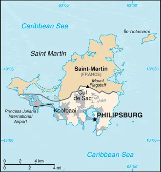
| Borderline map of Sint Maarten | Location map of Sint Maarten | Flag of Sint Maarten |
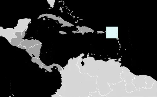
Google Maps and Detailed Facts of Sint Maarten (SX). This page lets you explore Sint Maarten and its border countries (Country Location: the Caribbean, located in the Leeward Islands (northern) group; Dutch part of the island of Saint Martin in the Caribbean Sea; Sint Maarten lies east of the US Virgin Islands) through detailed Satellite imagery – fast and easy as never before Google Maps.
Find comprehensive information about this country’s diversity below: Google Maps, geography, economy, science, people, culture, environment, government, and history – All in One Wiki page.
There is also a Street View and free Driving Directions at your service. Your Google Satellite Map Sightseeing in Sint Maarten, in Central America, and the Caribbean, starts here at Driving Directions and Maps.com.
Sint Maarten Google Maps & Satellite Maps
The map below shows Sint Maarten with its cities, towns, highways, main roads, streets, and Street Views. To find a location, use the form below, type any city or place, view a simple map, and click the “show map” button.
The Google Maps above shows Sint Maarten with its location: Central America, and the Caribbean (geographic coordinates: 18 4 N, 63 4 W) and the international borders of Sint Maarten; total: 16 km. Border countries (total: 1): Saint Martin (France) 16 km; furthermore, it’s inland counties boundaries.
Hint: Look at the Street view in Sint Maarten, or Central America, and the Caribbean. All you have to do is drag and pull the little yellow man (named: Pegman) on the Google Maps above the desired location. After that, whenever it is available (more than 50 countries globally), blue stripes will appear to show the photos and details from Google’s regularly updated data image base. In case if you have signed in to your Google account currently, you may have a look at the satellite map of this country/area as well.
The map of Sint Maarten, Central America, and the Caribbean is for informational use only. No representation is made or warrantied given any map or its content by Driving Directions and Maps site. The user assumes all risks of using this Sint Maarten Google Maps and facts/wiki.
About Sint Maarten in detail
Where is Sint Maarten?
Sint Maarten, in case, if you are looking on the map under the Coordinates 18 1 N 63 2 W otherwise in Central America, and the Caribbean, in the Caribbean, located in the Leeward Islands (northern) group; Dutch part of the island of Saint Martin in the Caribbean Sea; Sint Maarten lies east of the US Virgin Islands.
What is the capital city of Sint Maarten?
The capital city of Sint Maarten is: Philipsburg.
What is the time in Philipsburg?
It is 1 hour ahead of Washington, D.C. during Standard Time; Philipsburg’s timezone is UTC-4.
What is the Internet code for Sint Maarten?
The Top Level Domain (TLD) for Sint Maarten is: .sx
What is the size of Sint Maarten?
The territory of Sint Maarten is total: 34 sq km; land: 34 sq km, water: 0 sq km.
If we want to describe Sint’s size, Maarten’s territory is one-fifth the size of Washington, DC.
If we would like to walk around and discover Sint Maarten, we can cover a total distance: 16 km.
What is the water coverage of Sint Maarten?
We have already mentioned what percentage of Sint Maarten is covered by water (see below), and this includes 58.9 km (for the entire island) coastline.
What is the climate like in Sint Maarten?
Sint Maarten’s climate is a tropical marine climate, ameliorated by northeast trade winds, results in moderate temperatures: average rainfall of 150 cm/year: hurricane season stretches from July to November.
Geographical data of Sint Maarten
Sint Maarten’s elevation; mean elevation: N/A, elevation extremes; lowest point: the Caribbean Sea 0 m, highest point: Mount Flagstaff 386 m.
The specific geographical details of Sint Maarten include low, hilly terrain, volcanic origin.
Suppose we would like to describe the countries location from a different perspective. In that case, it is safe to say, and easy to read from a map, Sint Maarten is the northern border is shared with the French overseas collectivity of Saint-Martin; together, these two entities make up the smallest landmass in the world shared by two self-governing states.
Resources and land use of Sint Maarten
The country’s main mined products are fish, salt. The population partly uses the earlier highlighted land territory and partly left in its natural state: N/A.
Population data of Sint Maarten
The number of inhabitants of Sint Maarten is 41,486 (July 2016 estimate).
Let’s examine the proportion of the population distribution. It is safe to say that the most populous areas are Lower Prince’s Quarter (north of Philipsburg), followed closely by Cul de Sac.
If we look at the proportion of the urbanized and barely populated areas, these are the figures: urban population: 100% of the total population (2015).
Most of the population in Sint Maarten is concentrated in PHILIPSBURG (capital) 1,327 (2011).
Ethnicity in Sint Maarten
According to ethnicity details, the ethnic groups are N/A.
Spoken languages in Sint Maarten
The spoken languages in Sint Maarten are the following: English (official language) 67.5%, Spanish 12.9%, Creole 8.2%, Dutch (official language) 4.2%, Papiamento (a Spanish-Portuguese-Dutch-English dialect) 2.2%, French 1.5%, other 3.5% (2001 census).
What are the most important religions in Sint Maarten?
During the general census, researchers examine the churches, according to this: Protestant 41.9% (Pentecostal 14.7%, Methodist 10.0%, Seventh Day Adventist 6.6%, Baptist 4.7%, Anglican 3.1%, other Protestant 2.8%), Roman Catholic 33.1%, Hindu 5.2%, Christian 4.1%, Jehovah’s Witness 1.7%, Evangelical 1.4%, Muslim/Jewish 1.1%, other 1.3% (includes Buddhist, Sikh, Rastafarian), none 7.9%, no response 2.4% (2011 estimate).
Further population data of Sint Maarten
The proportion of gender and age tells a lot about the society as follows 0-14 years: 18.45% (male 4,000 / female 3,655) 15-24 years: 15.26% (male 3,127 / female 3,204) 25-54 years: 42.6% (male 8,628 / female 9,045) 55-64 years: 15.37% (male 3,057 / female 3,319) 65 years and over: 8.32% (male 1,667 / female 1,784) (2016 estimate). It also a significant factor in a society the population growth rate, which in the case of Sint Maarten is 1.44% (2016 estimate).
The population growth rate is based on two elements, the birth and the death rate. In Sint Maarten the birth rate is 13.1 births / 1,000 population (2016 estimate), the death rate 5 deaths / 1,000 population (2016 estimate).
In this day and age in developed societies, the first child borns later compared to the previous centuries and decades, so childbearing is extended. In Sint Maarten, the average age of mothers at the first childbirth is N/A.
Although the children’s birth is postponed in the best-case scenario, the parents can still see their kids grow as life expectancy also extended. In the case of Sint Maarten, these figures are. With the introduction of modern medicine, vaccinations, and the proper hygienic conditions, the infant mortality rate is in a steep decline. The infant mortality statistics in Sint Maarten are the following: N/A. Relevant data is the budget of healthcare, which is in the case of this country is N/A.
Economic data of Sint Maarten
Suppose we would like to describe a country. We also have to mention its economy; Sint Maarten’s economy centers around tourism, with nearly four-fifths of the labor force engaged in this sector. Almost 1.8 million visitors came to the island by cruise ship, and roughly 500,000 visitors arrived through Princess Juliana International.
GDP is a prominent figure, as all the relevant calculations and statistics are based on it. GDP in Sint Maarten is $304.1 billion (2014 estimate).
Another important indicator is the rate of GDP growth, which in Sint Maarten is 3.6% (2014 estimate), 4.1% (2013 estimate) 1.9% (2012 estimate).
These statistics affect the world economy; remember, in 2015, the Chinese real GDP growth rate was worse than expected; The world markets fall, and the Chinese stock exchange was temporarily suspended.
A further major factor of a country’s economy, the GDP per capita. In Sint Maarten this is $66,800 (2014 estimate) $65,500 (2013 estimate) $63,900 (2012 estimate).
In the economy, the Trinity is in common places, such as agriculture, industry, and services.
What are the agricultural products Sint Maarten produces?
The main agricultural products of Sint Maarten are sugar.
Regarding the economy, the essential segments are tourism, light industry. The crucial and regularly mentioned GDP is based on tourism, light industry.
Drinking water source in Sint Maarten
It is essential to mention that – thanks to the infrastructure development– the rate of potable water N/A.
The average number of childbirth in Sint Maarten
In Sint Maarten, the average delivery number is 2.06 children born / woman (2016 estimate).
Population, median age, migration, and citizenship in Sint Maarten
The population’s average age is 40.7 years; male: 39.8 years, female: 41.7 years (2016 estimate). The age of adulthood varies in every country of the world in Sint Maarten; it is 18 years of age, universal.
When we are experiencing an unprecedented scale of migration and globalization, it is an important factor in the number of new immigrants. In Sint Maarten is 6.3 migrant(s) / 1,000 population (2016 estimate). It is important to know how to apply for citizenship: see the Netherlands.
Is Sint Maarten a safe destination? Healthcare services and infectious diseases in Sint Maarten
Many of the travelers are looking into the healthcare services and infectious diseases of their destinations. In Sint Maarten, the hospital beds’ density is N/A.
According to the WHO rating regarding contagious diseases in Sint Maarten the note: active local transmission of Zika virus by Aedes species mosquitoes has been identified in this country (as of August 2016); it poses a significant risk (a large number of cases possible) among US citizens if bitten by an infective mosquito; other less common ways to get Zika are through sex, via blood transfusion, or during pregnancy, in which the pregnant woman passes Zika virus to her fetus (2016).
However, HIV is not curable but maintainable. Let’s do not forget when the disease surfaced; it was a world threatening condition. Unfortunately, in some countries, it is still very high the number of infected patients and fatalities due to the disease.
In Sint Maarten, the number of HIV/AIDS deaths: N/A.
Regarding tourism obesity, not an important issue, but we have to mention health statistics, as it is the plague of the 20th and the 21st century. The rate of obese adults in Sint Maarten is N/A.
What are the natural hazards in Sint Maarten? Is there any?
The most known natural risk in Sint Maarten is subject to hurricanes from July to November.
More interesting facts about Sint Maarten
Like every country and society, a few words about the past are connected to its history. However, Christopher COLUMBUS was sighted in 1493 and claimed Spain; it was the Dutch who occupied the island in 1631 and began exploiting its salt deposits. The Spanish retook the island in 1633 but continued to be harassed by the Dutch. The Spanish finally relinquished Saint Martin’s island to the French and Dutch, who divided it amongst themselves in 1648.
The establishment of cotton, tobacco, and sugar plantations dramatically expanded African slavery on the island in the 18th and 19th centuries; the practice was not abolished in the Dutch half until 1863. The island’s economy declined until 1939, when it became a free port; the tourism industry was dramatically expanded beginning in the 1950s. In 1954, Sint Maarten and several other Dutch Caribbean possessions became part of the Kingdom of the Netherlands as the Netherlands Antilles. In a 2000 referendum, Sint Maarten’s citizens voted to become a self-governing country within the Kingdom of the Netherlands. The change in status became effective in October of 2010 with the dissolution of the Netherlands Antilles.
In every nation’s memory, some cornerstones placed the country on the timeline of history. The date of declaration of independence of Sint Maarten: none (part of the Kingdom of the Netherlands).
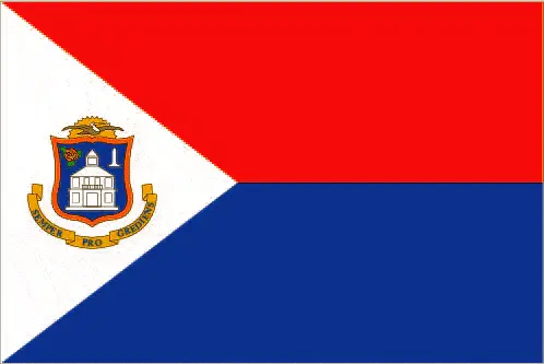
The flag and other symbols of Sint Maarten
The colors, symbols, and animals on the flag usually have a historical background or an important milestone or memory of the nation.
This case is not an exception either; two equal horizontal bands of red (top) and blue with a white isosceles triangle based on the hoist side; the center of the triangle displays the Sint Maarten coat of arms; the arms consist of an orange-bordered blue shield prominently displaying the white courthouse in Philipsburg, as well as a bouquet of yellow sage (the national flower) in the upper left, and the silhouette of a Dutch-French friendship monument in the upper right; the shield is surmounted by a yellow rising sun in front of which is a brown pelican in flight; a yellow scroll below the shield, bears the motto: SEMPER PROGREDIENS (Always Progressing); the three primary colors are identical to those on the Dutch flag. Note: the flag somewhat resembles that of the Philippines, but the main red and blue bands are reversed; the banner more closely evokes the wartime Philippine flag.
Apart from the flag, the symbol of national unity is the national anthem. The anthem’s primary purpose is to share the nation’s core values, endeavors, and patriotic feelings.
National symbols of Sint Maarten: brown pelican, yellow sage (flower); national colors: red, white, blue.
Constitution of Sint Maarten
The existence of the nation is based on the constitution. Some constitutions knew worldwide, like the U.S. Constitution that was accepted on the 17th of September 1787, in Philadelphia, the United States of America’s Constitution.
It is not related to the declaration of independence that was stolen by Nicolas Cage in the movie National Treasure 🙂
What is the legal system of Sint Maarten?
Most of the time, the legal system of a country is the focus of lawyers. It is a common fact that there are two main approaches in the world, “the law in books” and “the law in action.”
In the Anglo-Saxon world, the practice is the “law in action,” while in the rest of the world, the law is based on Roman law, the “law in books.”
The legal system of Sint Maarten is based on the Dutch civil law system with some English common law influence.
It was Aristotle who founded the Theory of 3 separations of powers. In his view, these are the council of public affairs, the magistrates, and the justice system. The age of enlightenment was the time when terminologies have defined the way we still use them. In most democratic countries, the three authorities separated from each other. In dictatorships, the rules usually interweaved in one hand.
We can highlight the following structures unicameral Estates of Sint Maarten or Staten (15 seats; members directly elected by proportional representation vote to serve 4-year terms) about the legislative branch of Sint Maarten.
About the unemployment rate, labor force, and poverty line in Sint Maarten
One of the major problems of the 21st-century economy is unemployment. Governments are struggling to maintain a low level of the unemployment rate. Still, as a result of automation, the cheap 3rd world labor, and the outsourcing of workflow, these attempts fail. In Sint Maarten, the labor force is 23,200 (2008 estimate). Please bear in mind that the population in Sint Maarten is total: 8.3 deaths / 1,000 live births; male: 9.1 deaths / 1,000 live births, female: 7.6 deaths / 1,000 live births (2016 estimate) – as we already mentioned above.
The rate of unemployment in Sint Maarten is 12% (2012 estimate).
Widely known that the gap between the rich and poor is widening on an enormous scale.
According to the 2017 shocking Oxfam report, the most affluent eight people’s fortune is equal to the wealth of the poorest half of the world’s population.
In Sint Maarten, the households’ income and consumption compared to the entire population: N/A.
Another widely used indicator is the so-called GINI index, which measures the inequalities of statistical dispersion, but is mainly used for measuring the sharing of income and fortune.
The GINI index was named after its founder Corrado Gini, an Italian economist. Gini index has grades between 0-1, but often it is used on a percentage basis. It is 0 if the examined criteria territorial distribution is equal. It is one of the criteria concentrated on the territory. In Sint Maarten, the GINI index is N/A.
The states usually set up a poverty line, which is more or less, is a subjective measure. It varies by country; its base is often the minimum pension, the incomes of the most deficient 20 percent, the X percent of income per capita Etc.
In Sint Maarten, the number of people living under the poverty line is N/A.
About the budget and central governments debt of Sint Maarten
The available budget mainly defines the state’s economy. The budget of Sint Maarten is; N/A. Taxes and other revenues are N/A.
The budget deficit (Budget surplus (+) or deficit (-)) is N/A.
The fiscal year in Sint Maarten is N/A.
In the country’s economy, we have to consider the public debt. Public debt is the consolidated sum of the state’s local, federal, and central government debt.
Inflation rate and prime lending rate in Sint Maarten
A few further interesting and relevant economic data are the following; Inflation rate: 4% (2012 estimate), 0.7% (2009 estimate), and the commercial bank prime lending rate: N/A.
Export/import partners and data of Sint Maarten
Sint Maarten, with the export of products, industrial tools, and other services, generates revenue. The export value in Sint Maarten is N/A. The total revenue of these activities: sugar.
The most important export partners of Sint Maarten are N/A.
The most important imported products are N/A, and the countries where the import is coming: N/A.
Renewable energies used in Sint Maarten
To suppress the pollution of the environment, renewable energies have to replace the fossil energy. The more the proportion of renewable energies in a country means more effort against pollution. Sint Maarten, the indicator of how much of the country’s produced energy is coming from the hydroelectric source, is N/A.
To indicate how much another renewable energy produced is N/A.
Telecommunication data of Sint Maarten, calling code
To maintain the economy, the development of a reliable and modern telecommunications infrastructure is crucial. We can say the following about Sint Maarten; generally adequate facilities. Domestic: extensive interisland microwave radio relay links. International: country code – 1-721; the Americas Region Caribbean Ring System (ARCOS-1) and the Americas-2 submarine cable systems provide connectivity to Central America, parts of South America and the Caribbean, and the US; satellite earth stations – 2 Intelsat (Atla (2010).
Transport infrastructure in Sint Maarten
In the 21st century, we often say that the world has become small and there are no distances anymore. With widespread air travel when (sometimes) there are no visa restrictions, it is easy to reach other countries, but if the distance is not too long, we can also use railway or water transportation.
The number of airports in Sint Maarten: 1 (2013), and the number of heliports: N/A.
The total length of the roadways in Sint Maarten: total: 53 km.
The total length of the waterways in Sint Maarten: N/A.
Are you traveling to Sint Maarten?
If you plan to travel by plane to Sint Maarten, try our air ticket comparison site, where you can choose from hundreds of carriers and offers. Our application is scanning the market and shows you the best and the cheapest deals without any extra charge or commission.
Are you looking for a hotel, apartment another kind of accommodation in Sint Maarten, Central America, and the Caribbean? We are here to help you to find your accommodation from budget to luxury. Our search engine is scanning, regularly updating data from hundreds of accommodation websites and more than a million offers. You can quickly and easily find your hotel stay anywhere in the world, without any extra charge or commission.
Facts & data about Sint Maarten
Name of the country: Dutch long form: Land Sint MaartenDutch short form: Sint MaartenEnglish long form: Country of Sint Maarten, English short form: Sint Maarten, former: Netherlands Antilles; Curacao and Dependencies, etymology: explorer Christopher COLUMBUS named the island after Saint MARTIN of Tours because the 11 November 1493 day of discovery was the saint’s feast day.
| Abbreviation: Sint Maarten | Geographic coordinates: 18 4 N, 63 4 W |
Country Location: Central America and the Caribbean |
| Capital of Sint Maarten: Philipsburg | GPS of the Capital: 18 1 N 63 2 W |
Position: the Caribbean, located in the Leeward Islands (northern) group; Dutch part of the island of Saint Martin in the Caribbean Sea; Sint Maarten lies east of the US Virgin Islands |
| Land area: total: 34 sq km; land: 34 sq km, water: 0 sq km | Terrain: low, hilly terrain, volcanic origin |
Area comparative: one-fifth the size of Washington, DC |
| Population: 41,486 (July 2016 estimate) | Population grow rate: 1.44% (2016 estimate) | Sex ratio: at birth: 1.05 male(s) / female, 0-14 years: 1.09 male(s) / female, 15-24 years: 0.98 male(s) / female, 25-54 years: 0.95 male(s) / female, 55-64 years: 0.92 male(s) / female, 65 years and over: 0.92 male(s) / female, total population: 0.98 male(s) / female (2016 estimate) |
| Exports: N/A | Imports: N/A | Import partners: N/A |
| Urbanization: urban population: 100% of the total population (2015) | Major urban area(s): PHILIPSBURG (capital) 1,327 (2011) | Median age: total: 40.7 years; male: 39.8 years, female: 41.7 years (2016 estimate) |
| Internet users: N/A | Telephones (fixed-lines): N/A | Telephones (mobile, cellular): N/A |
| Unemployment rate: 12% (2012 estimate) | Nationality: N/A | National holidays: King’s Day (birthday of King WILLEM-ALEXANDER), 27 April (1967) |
| Life expectancy at birth: total population: 78.1 years. Male: 75.8 years, female: 80.6 years (2016 estimate) | Total fertility rate: 2.06 children born / woman (2016 estimate) | Birthrate: 13.1 births / 1,000 population (2016 estimate) |
| Literacy: N/A | Legal system: based on Dutch civil law system with some English common law influence | Suffrage: 18 years of age, universal |
| Industries: tourism, light industry | Industrial production growth rate: N/A | GDP real growth rate: 3.6% (2014 estimate) 4.1% (2013 estimate) 1.9% (2012 estimate) |
Do you like this Sint Maarten Google Maps & country information page?
Please do us a favor: Share or like this page using the icons at the top of the page. We also do encourage you to visit our Facebook page for more travel and country related information.
Many thanks for visiting and sharing this map & country information site!