
 |
 |
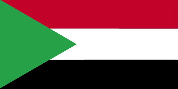 |
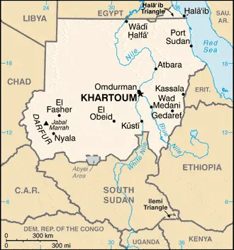
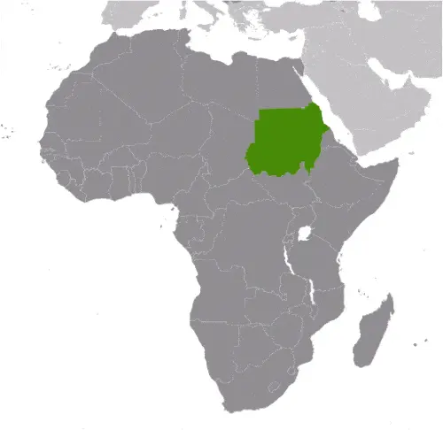
| Borderline map of Sudan | Location map of Sudan | Flag of Sudan |
Google Maps and Detailed Facts of Sudan (SD). This page lets you explore Sudan and its border countries (Country Location: north-eastern Africa, bordering the Red Sea, between Egypt and Eritrea) through detailed Satellite imagery – fast and easy as never before Google Maps.
Find comprehensive information about this country’s diversity below: Google maps, geography, economy, science, people, culture, environment, government, and history – All in One Wiki page.
There is also a Street View and free Driving Directions at your service. Your Google Satellite Map Sightseeing in Sudan, in Africa, starts here at Driving Directions and Maps.com.
Sudan Google Maps & Satellite Maps
The map below shows Sudan with its cities, towns, highways, main roads, streets, and Street Views. To find a location, use the form below, type any city or place, view a simple map, and click the “show map” button.
The Google map above shows Sudan with its location: Africa (geographic coordinates: 15 00 N, 30 00 E) and the international borders of Sudan; total: 6,819 km. Border countries (total: 7): Central African Republic 174 km, Chad 1,403 km, Egypt 1,276 km, Eritrea 682 km, Ethiopia 744 km, Libya 382 km, South Sudan 2,158 km. Note: Sudan-South Sudan boundary represents 1 January 1956 alignment; final alignment pending negotiations and demarcation; final sovereignty status of Abyei region pending negotiations between Sudan and South Sudan; furthermore, it’s inland counties boundaries.
Hint: Look at the Street view in Sudan or Africa. All you have to do is drag and pull the little yellow man (named: Pegman) on the Google map above the desired location. After that, whenever it is available (more than 50 countries globally), blue stripes will appear to show the photos and details from Google’s regularly updated data image base. In case if you have signed in to your Google account currently, you may have a look at the satellite map of this country/area as well.
The map of Sudan, Africa, is for informational use only. No representation is made or warrantied given any map or its content by Driving Directions and Maps site. The user assumes all risks of using this Sudan Google map and facts/wiki.
About Sudan in detail
Where is Sudan?
Sudan, in case, if you are looking on the map under the Coordinates 15 36 N 32 32 E otherwise in Africa, in north-eastern Africa, bordering the Red Sea, between Egypt and Eritrea.
What is the capital city of Sudan?
The capital city of Sudan is Khartoum.
What is the time in Khartoum?
It is 8 hours ahead of Washington, D.C. during Standard Time; Khartoum’s timezone is UTC+3.
What is the Internet code for Sudan?
The Top Level Domain (TLD) for Sudan is: .sd
What is the size of Sudan?
Sudan’s territory is a total: 1,861,484 sq km; land: NA, water: NA.
If we want to describe the size of Sudan’s territory is slightly less than one-fifth the size of the US.
If we would like to walk around and discover Sudan, we can cover a total distance: 6,819 km.
What is the water coverage of Sudan?
We have already mentioned what percentage of Sudan is covered by water (see below), including an 853 km coastline.
What is the climate like in Sudan?
Sudan’s climate is hot and dry: arid desert: rainy season varies by region (April to November).
Geographical data of Sudan
Sudan’s elevation; mean elevation: 568 m, elevation extremes; lowest point: the Red Sea 0 m, highest point: Jabal Marrah 3,071 m.
The specific geographical details of Sudan include generally flat, featureless plain; desert dominates the north.
Suppose we would like to describe the countries location from a different perspective. In that case, it is safe to say, and easy to read from a map, Sudan is dominated by the Nile and its tributaries.
Resources and land use of Sudan
The country’s main mined products are petroleum; small reserves of iron ore, copper, chromium ore, zinc, tungsten, mica, silver, gold; hydropower. The population partly uses the earlier highlighted land territory and partly left in its natural state: agricultural land: 100%; arable land 15.7%; permanent crops 0.2%; permanent pasture 84.2%; forest: 0%; other: 0% (2011 estimate).
Population data of Sudan
The number of inhabitants of Sudan is 36,729,501 (July 2016 estimate).
If we examine the proportion of the population distribution, it is safe to say that except a ribbon of settlement that corresponds to the banks of the Nile, northern Sudan, which extends into the dry Sahara, is sparsely populated; more abundant vegetation and broader access to water increase population distribution in the south extending habitable range along nearly the entire border with South Sudan; sizeable areas of the population are found around Khartoum, southeast between the Blue and White Nile Rivers, and throughout South Darfur.
If we look at the proportion of the urbanized and barely populated areas, these are the figures: urban population: 33.8% of the total population (2015).
Most of Sudan’s population is concentrated in KHARTOUM (capital), 5.129 million (2015).
Ethnicity in Sudan
According to ethnicity details, the ethnic groups are Sudanese Arab (approximately 70%), Fur, Beja, Nuba, Fallata.
Spoken languages in Sudan
The spoken languages in Sudan are the following: Arabic (official language), English (official language), Nubian, Ta Bedawie, Fur.
What are the most important religions in Sudan?
According to this: Sunni Muslim, small Christian minority during the general census, researchers examine the churches.
Further population data of Sudan
The proportion of gender and age tells a lot about the society as follows 0-14 years: 39.43% (male 7,351,759 / female 7,130,224) 15-24 years: 20.77% (male 3,926,374 / female 3,703,826) 25-54 years: 32.42% (male 5,779,482 / female 6,129,213) 55-64 years: 4.12% (male 793,848 / female 721,075) 65 years and over: 3.25% (male 645,876 / female 547,824) (2016 estimate). It also a significant factor in a society the population growth rate, which in the case of Sudan is 1.69% (2016 estimate).
The population growth rate is based on two elements, the birth, and the death rate. In Sudan the birth rate is 28.5 births / 1,000 population (2016 estimate), the death rate 7.5 deaths / 1,000 population (2016 estimate).
In this day and age in developed societies, the first child borns later compared to the previous centuries and decades, so childbearing is extended. In Sudan, the average age of mothers at the first childbirth is N/A.
Although the children’s birth is postponed in the best-case scenario, the parents can still see their kids grow as life expectancy also extended. In the case of Sudan, these figures are. With the introduction of modern medicine, vaccinations, and the proper hygienic conditions, the infant mortality rate is in a steep decline. The infant mortality statistics in Sudan are the following: N/A. Relevant data is the budget of healthcare, which is in the case of this country is 8.4% of GDP (2014).
Economic data of Sudan
Suppose we would like to describe a country, we also have to mention its economy; Sudan has experienced protracted social conflict, civil war, and, in July 2011, the loss of three-quarters of its oil production secession of South Sudan. The oil sector had driven much of Sudan’s GDP growth since 1999. Sudan is also subject to comprehensive US sanctions. Sudan is attempting to develop non-oil sources of revenues, such as gold mining while carrying out an austerity program to reduce expenditures. The world’s largest exporter of gum Arabic. Sudan introduced a new currency, still called the Sudanese pound, following South Sudan’s secession, but the value of the currency has fallen since its introduction. Khartoum devalued the currency in June 2012 and November 2016, in both cases to accompany.
GDP is a prominent figure, as all the relevant calculations and statistics are based on it. GDP in Sudan is $94.3 billion (2015 estimate).
Another important indicator is the rate of GDP growth, which in Sudan is 3.1% (2016 estimate), 4.9% (2015 estimate) 1.6% (2014 estimate).
These statistics affect the world economy; remember, in 2015, the Chinese real GDP growth rate was worse than expected; The world markets fall, and the Chinese stock exchange was temporarily suspended.
A further major factor of a country’s economy, the GDP per capita. In Sudan this is $4,500 (2016 estimate) $4,500 (2015 estimate) $4,400 (2014 estimate).
In the economy, the Trinity is in common places, such as agriculture, industry, and services.
What are the agricultural products Sudan produces?
Sudan’s main agricultural products are cotton, groundnuts (peanuts), sorghum, millet, wheat, gum Arabic, sugarcane, cassava (manioc, tapioca), mangoes, papaya, bananas, sweet potatoes, sesame seeds; animal feed, sheep, and other livestock.
The essential segments are oil, cotton ginning, textiles, cement, edible oils, sugar, soap distilling, shoes, petroleum refining, pharmaceuticals, armaments, automobile/light truck assembly, milling. The crucial and regularly mentioned GDP is based on oil, cotton ginning, textiles, cement, edible oils, sugar, soap distilling, shoes, petroleum refining, pharmaceuticals, armaments, automobile/light truck assembly, milling.
Drinking water source in Sudan
It is essential to mention that – thanks to the development of the infrastructure -, the rate of potable water improved: urban: 66% of the population, rural: 50.2% of the people, total: 55.5% of the population. Unimproved: urban: 34% of the population, rural: 49.8% of the population, total: 44.5% of the population (2012 estimate).
The average number of childbirth in Sudan
In Sudan, the average delivery number is 3.68 children born / woman (2016 estimate).
Population, median age, migration, and citizenship in Sudan
The population’s average age is 19.6 years; male: 19.4 years, female: 19.9 years (2016 estimate). The age of adulthood varies in every country of the world. In Sudan, it is 17 years of age, universal.
When we are experiencing an unprecedented scale of migration and globalization, it is an important factor in the number of new immigrants. In Sudan is -4.2 migrant(s) / 1,000 population (2016 estimate). It is important to know how to apply for citizenship: citizenship by birth: no. Citizenship by descent only: the father must be a citizen of Sudan. Dual citizenship recognized: no—the residency requirement for naturalization: 10 years.
Is Sudan a safe destination? Healthcare services and infectious diseases in Sudan
Many of the travelers are looking into the healthcare services and infectious diseases of their destinations. In Sudan, the hospital beds’ density is 0.8 beds / 1,000 population (2012).
According to the WHO rating regarding contagious diseases in Sudan, the degree of risk: very high food or waterborne diseases: bacterial and protozoal diarrhea, hepatitis A and E, and typhoid fever vectorborne diseases: malaria, dengue fever, and Rift Valley fever water contact disease: schistosomiasis. Respiratory disease: meningococcal meningitis animal contact disease: rabies (2016).
However, HIV is not curable but maintainable. Let’s do not forget when the disease surfaced; it was a world threatening condition. Unfortunately, in some countries, it is still very high the number of infected patients and fatalities due to the disease.
In Sudan, the number of HIV/AIDS deaths: N/A.
Regarding tourism obesity, not an important issue, but we have to mention health statistics, as it is the plague of the 20th and the 21st century. The rate of obese adults in Sudan is 6.6% (2014).
What are the natural hazards in Sudan? Is there any?
The most known natural risk in Sudan is dust storms and periodic persistent droughts.
More interesting facts about Sudan
Like every country and society, a few words about the past are connected to its history; Military regimes favoring Islamic-oriented governments have dominated national politics since independence from Anglo-Egyptian co-rule in 1956. Sudan was embroiled in two prolonged civil wars during most of the remainder of the 20th century. These conflicts were rooted in northern economic, political, and social domination of predominantly non-Muslim, non-Arab southern Sudanese. The first civil war ended in 1972, but another broke out in 1983. Peace talks gained momentum in 2002-04 with the signing of several accords. The final North/South Comprehensive Peace Agreement (CPA), signed in January 2005, granted the southern rebels autonomy for six years, followed by a referendum on independence for Southern Sudan. The referendum was held in January 2011 and indicated overwhelming support for independence. South Sudan became independent on 9 July 2011. Sudan and South Sudan have yet to fully implement security and economic agreements signed in September 2012 relating to the normalization of relations between them. The final disposition of the contested Abyei region also has to be decided.
Since South Sudan’s independence, the conflict has broken out between the government and the Sudan People’s Liberation Movement-North in Southern Kordofan and the Blue Nile states, resulting in 1.2 million internally displaced persons severely affected persons needing humanitarian assistance. A separate conflict, which broke out in the western region of Darfur in 2003, displaced nearly two million people and caused an estimated 200,000 to 400,000 deaths. Violence in Darfur in 2013 resulted in an additional estimated 6,000 civilians killed and 500,000 displaced. The UN and the African Union have jointly commanded a Darfur peacekeeping operation known as the African Union-United Nations Hybrid Mission in Darfur (UNAMID) since 2007. Peacekeeping troops have struggled to stabilize the situation and have increasingly become targets for attacks by armed groups. Sudan also has faced refugee influxes from neighboring countries, primarily Ethiopia, Eritrea, Chad, Central African Republic, and South Sudan. Armed conflict, poor transport infrastructure, and government denial of access have impeded humanitarian assistance to affected populations.
In every nation’s memory, some cornerstones placed the country on the timeline of history. The date of declaration of independence of Sudan: 1 January 1956 (from Egypt and the UK).
The flag and other symbols of Sudan
The colors, symbols, and animals on the flag usually have a historical background or an important milestone or memory of the nation.
This case is not an exception either; three equal horizontal bands of red (top), white, and black with a green isosceles triangle based on the hoist side; colors and design based on the Arab Revolt flag of World War I, but the meanings of the colors are expressed as follows: red signifies the struggle for freedom, white is the color of peace, light, and love, black represents the people of Sudan (in Arabic ‘Sudan’ means black), green is the color of Islam, agriculture, and prosperity.
Apart from the flag, the symbol of national unity is the national anthem. The anthem’s primary purpose is to share the nation’s core values, endeavors, and patriotic feelings.
National symbols of Sudan: secretary bird; national colors: red, white, black, green.
Constitution of Sudan
The existence of the nation is based on the constitution. Some constitutions knew worldwide, like the U.S. Constitution that was accepted on the 17th of September 1787, in Philadelphia, the United States of America’s Constitution.
It is not related to the declaration of independence that was stolen by Nicolas Cage in the movie National Treasure 🙂
What is the legal system of Sudan?
Most of the time, the legal system of a country is the focus of lawyers. It is a common fact that there are two main approaches in the world, “the law in books” and “the law in action.”
In the Anglo-Saxon world, the practice is the “law in action,” while in the rest of the world, the law is based on Roman law, the “law in books.”
The legal system of Sudan is a mixed legal system of Islamic law and English common law.
It was Aristotle who founded the Theory of 3 separations of powers. In his view, these are the council of public affairs, the magistrates, and the justice system. The age of enlightenment was the time when terminologies have defined the way we still use them. In most democratic countries, the three authorities separated from each other. In dictatorships, the rules usually interweaved in one hand.
About the legislative branch of Sudan, we can highlight the following structures bicameral National Legislature consists of the Council of States or Majlis al-Wilayat (50 seats; members indirectly elected – 2 each by the 25 state legislatures to serve 6-year terms) and the National Assembly or Majlis Watani (426 seats; 213 members directly elected in single-seat constituencies by simple majority vote, 128 for women only directly elected by proportional representation vote, and 85 directly elected by proportional representation vote; members serve 6-year terms).
About the unemployment rate, labor force, and poverty line in Sudan
One of the major problems of the 21st-century economy is unemployment. Governments are struggling to maintain a low level of the unemployment rate. Still, as a result of automation, the cheap 3rd world labor, and the outsourcing of workflow, these attempts fail. In Sudan, the labor force is 11.92 million (2007 estimate). Please bear in mind that the population in Sudan is total: 50.2 deaths / 1,000 live births; male: 55.4 deaths / 1,000 live births, female: 44.6 deaths / 1,000 live births (2016 estimate) – as we already mentioned above.
The rate of unemployment in Sudan is 13.6% (2014 estimate).
Widely known that the gap between the rich and poor is widening on an enormous scale.
According to the 2017 shocking Oxfam report, the most affluent eight people’s fortune is equal to the wealth of the poorest half of the world’s population.
In Sudan, the households’ income and consumption compared to the entire population: lowest 10%: 2.7% highest 10%: 26.7% (2009 estimate).
Another widely used indicator is the so-called GINI index, which measures the inequalities of statistical dispersion, but is mainly used for measuring the sharing of income and fortune.
The GINI index was named after its founder Corrado Gini, an Italian economist. Gini index has grades between 0-1, but often it is used on a percentage basis. It is 0 if the examined criteria territorial distribution is equal. It is one of the criteria concentrated on the territory. In Sudan, the GINI index is N/A.
The states usually set up a poverty line, which is more or less, is a subjective measure. It varies by country; its base is often the minimum pension, the incomes of the most deficient 20 percent, the X percent of income per capita Etc.
In Sudan, the poverty line people are the lowest 10%: 2.7% highest 10%: 26.7% (2009 estimate).
About the budget and central governments debt of Sudan
The available budget mainly defines the state’s economy. Sudan’s budget is; revenues: $7.301 billion, expenditures: $11.28 billion (2016 estimate). Taxes and other revenues are 7.7% of GDP (2016 estimate).
The budget deficit (Budget surplus (+) or deficit (-)) is N/A.
The fiscal year in Sudan is the calendar year.
In the country’s economy, we have to consider the public debt. Public debt is the consolidated sum of the state’s local, federal, and central government debt.
Inflation rate and prime lending rate in Sudan
A few further interesting and relevant economic data are the following; Inflation rate: 17.6% (2016 estimate), 17.3% (2015 estimate), and the commercial bank prime lending rate: N/A.
Export/import partners and data of Sudan
Sudan, with the export of products, industrial tools, and other services, generates revenue. Sudan’s export value is $3.703 billion (2016 estimate), $3.169 billion (2015 estimate). The total revenue of these activities: gold; oil and petroleum products; cotton, sesame, livestock, peanuts, gum Arabic, sugar.
Sudan’s most important export partners are the UAE 32%, China 16.2%, Saudi Arabia 15.5%, Australia 4.7%, India 4.2% (2015).
The most important imported products are foodstuffs, manufactured goods, refinery, and transport equipment, medicines, chemicals, textiles, wheat, and the countries from where the import is coming: China 26.4%, UAE 10.1%, India 9.1%, Egypt 5.6%, Turkey 4.7%, Saudi Arabia 4.4% (2015).
Renewable energies used in Sudan
To suppress the pollution of the environment, renewable energies have to replace the fossil energy. The more the proportion of renewable energies in a country means more effort against pollution. Sudan, the indicator of how much of the country’s produced energy is coming from the hydroelectric source, is 66.3% of total installed capacity (2012 estimate).
To indicate how much another renewable energy produced is 3% of total installed capacity (2012 estimate).
Telecommunication data of Sudan, calling code
To maintain the economy, the development of a reliable and modern telecommunications infrastructure is crucial. We can say the following about Sudan; well-equipped system by regional standards and upgraded; cellular communications started in 1996 and have expanded substantially with a comprehensive coverage of most major cities. Domestic: consists of a microwave radio relay, cable, fiber optic, radiotelephone communications, tropospheric scatter, and a domestic satellite system with 14 earth stations. International: country code – 249; linked to the EASSy and FLAG fiber-optic submarine cable systems; satellite earth stations – 1 Intelsat (Atlantic Ocean), 1 Arabsat (2010).
Transport infrastructure in Sudan
In the 21st century, we often say that the world has become small and there are no distances anymore. With widespread air travel when (sometimes) there are no visa restrictions, it is easy to reach other countries, but if the distance is not too long, we can also use railway or water transportation.
The number of airports in Sudan: 74 (2013), and the number of heliports: 6 (2013).
The total length of the roadways in Sudan: 11,900 km, paved: 4,320 km, unpaved: 7,580 km (2000).
The total length of the waterways in Sudan: 4,068 km (1,723 km open year-round on White and Blue Nile Rivers) (2011).
Are you traveling to Sudan?
If you plan to travel by plane to Sudan, try our air ticket comparison site, where you can choose from hundreds of carriers and offers. Our application is scanning the market and shows you the best and the cheapest deals without any extra charge or commission.
Are you looking for a hotel, apartment another kind of accommodation in Sudan, Africa? We are here to help you to find your accommodation from budget to luxury. Our search engine is scanning, regularly updating data from hundreds of accommodation websites and more than a million offers. You can quickly and easily find your hotel stay anywhere in the world, without any extra charge or commission.
Facts & data about Sudan
Name of the country: conventional long way: the Republic of Sudan, traditional short form: Sudan, local long form: Jumhuriyat as-Sudan, local short state: As-Sudan, former: Anglo-Egyptian Sudan, etymology: the name “Sudan” derives from the Arabic “bilad-as-sudan” meaning “Land of the black [peoples].”
| Abbreviation: Sudan | Geographic coordinates: 15 00 N, 30 00 E |
Country Location: Africa |
| Capital of Sudan: Khartoum | GPS of the Capital: 15 36 N 32 32 E |
Position: north-eastern Africa, bordering the Red Sea, between Egypt and Eritrea |
| Land area: total: 1,861,484 sq km; land: NAwater: NA | Terrain: generally flat, featureless plain; desert dominates the north |
Area comparative: slightly less than one-fifth the size of the US |
| Population: 36,729,501 (July 2016 estimate) | Population grow rate: 1.69% (2016 estimate) | Sex ratio: at birth: 1.05 male(s) / female, 0-14 years: 1.03 male(s) / female, 15-24 years: 1.06 male(s) / female, 25-54 years: 0.94 male(s) / female, 55-64 years: 1.1 male(s) / female, 65 years and over: 1.19 male(s) / female, total population: 1.02 male(s) / female (2016 estimate) |
| Exports: $3.703 billion (2016 estimate), $3.169 billion (2015 estimate) | Imports: $9.345 billion (2016 estimate), $8.368 billion (2015 estimate) | Import partners: China 26.4%, UAE 10.1%, India 9.1%, Egypt 5.6%, Turkey 4.7%, Saudi Arabia 4.4% (2015) |
| Urbanization: urban population: 33.8% of the total population (2015) | Major urban area(s): KHARTOUM (capital) 5.129 million (2015) | Median age: total: 19.6 years; male: 19.4 years, female: 19.9 years (2016 estimate) |
| Internet users: total: 9.61 million. Percent of the population: 26.6% (July 2015 estimate) | Telephones (fixed-lines): total subscriptions: 118,954. Subscriptions per 100 inhabitants: less than 1 (July 2015 estimate) | Telephones (mobile, cellular): total: 27.939 million. Subscriptions per 100 inhabitants: 77 (July 2015 estimate) |
| Unemployment rate: 13.6% (2014 estimate) | Nationality: Sudanese (singular and plural) adjective: Sudanese | National holidays: Independence Day, 1 January (1956) |
| Life expectancy at birth: total population: 64.1 years. Male: 62 years, female: 66.3 years (2016 estimate) | Total fertility rate: 3.68 children born / woman (2016 estimate) | Birthrate: 28.5 births / 1,000 population (2016 estimate) |
| Literacy: age 15 and over can read and write. Total population: 75.9%; male: 83.3%, female: 68.6% (2015 estimate) | Legal system: mixed legal system of Islamic law and English common law | Suffrage: 17 years of age, universal |
| Industries: oil, cotton ginning, textiles, cement, edible oils, sugar, soap distilling, shoes, petroleum refining, pharmaceuticals, armaments, automobile/light truck assembly, milling | Industrial production growth rate: 2.5% (2016 estimate) | GDP real growth rate: 3.1% (2016 estimate) 4.9% (2015 estimate) 1.6% (2014 estimate) |
Do you like this Sudan Google maps™ & country information page?
Please do us a favor: Share or like this page using the icons at the top of the page. We also do encourage you to visit our Facebook page for more travel and country related information.
Many thanks for visiting and sharing this map & country information site!