
 |
 |
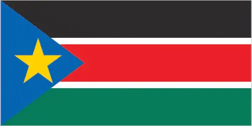 |
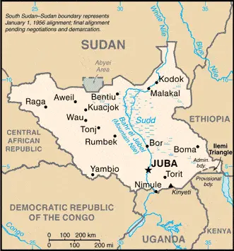
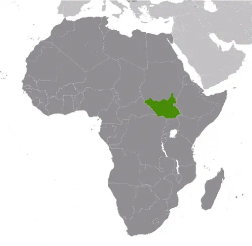
| Borderline map of South Sudan | Location map of South Sudan | Flag of South Sudan |
Google Maps and Detailed Facts of South Sudan (SS). This page lets you explore South Sudan and its border countries (Country Location: East-Central Africa; south of Sudan, north of Uganda and Kenya, west of Ethiopia) through detailed Satellite imagery – fast and easy as never before Google Maps.
Find comprehensive information about this country’s diversity below: Google Maps, geography, economy, science, people, culture, environment, government, and history – All in One Wiki page.
There is also a Street View and free Driving Directions at your service. Your Google Satellite Map Sightseeing in South Sudan, in Africa, starts here at Driving Directions and Maps.com.
South Sudan Google Maps & Satellite Maps
The map below shows South Sudan with its cities, towns, highways, main roads, streets, and Street Views. To find a location, use the form below, type any city or place, view a simple map, and click the “show map” button.
The Google Maps above shows South Sudan with its location: Africa (geographic coordinates: 8 00 N, 30 00 E) and the international borders of South Sudan; total: 6,018 km. Border countries (total: 6): Central African Republic 1,055 km, the Democratic Republic of the Congo 714 km, Ethiopia 1,299 km, Kenya 317 km, Sudan 2,158 km, Uganda 475 km. Note: South Sudan-Sudan boundary represents 1 January 1956 alignment; final alignment pending negotiations and demarcation; final sovereignty status of Abyei Area pending negotiations between South Sudan and Sudan; furthermore, it’s inland counties boundaries.
Hint: Look at the Street view in South Sudan or Africa. All you have to do is drag and pull the little yellow man (named: Pegman) on the Google Maps above the desired location. After that, whenever it is available (more than 50 countries globally), blue stripes will appear to show the photos and details from Google’s regularly updated data image base. In case if you have signed in to your Google account currently, you may have a look at the satellite map of this country/area as well.
The map of South Sudan, Africa, is for informational use only. No representation is made or warrantied given any map or its content by Driving Directions and Maps site. The user assumes all risks of using this South Sudan Google Maps and facts/wiki.
About South Sudan in detail
Where is South Sudan?
South Sudan, in case, if you are looking on the map under the Coordinates 04 51 N 31 37 E otherwise in Africa, in East-Central Africa; south of Sudan, north of Uganda and Kenya, west of Ethiopia.
What is the capital city of South Sudan?
The capital city of South Sudan is Juba.
What is the time in Juba?
It is 8 hours ahead of Washington, D.C. during Standard Time; Juba’s timezone is UTC+3.
What is the Internet code for South Sudan?
The Top Level Domain (TLD) for South Sudan is: .ss
What is the size of South Sudan?
The territory of South Sudan is a total: 644,329 sq km; land: NA, water: NA.
If we want to describe the size of the territory of South Sudan is more than four times the size of Georgia, somewhat smaller than Texas.
If we would like to walk around and discover South Sudan, we can cover a total distance: 6,018 km.
What is the water coverage of South Sudan?
We have already mentioned what percentage of South Sudan is covered by water (see below), and this includes 0 km (landlocked country) coastline.
What is the climate like in South Sudan?
The climate of South Sudan is hot with seasonal rainfall influenced by the annual shift of the Inter-Tropical Convergence Zone: rain heaviest in upland areas of the south and diminishes to the north.
Geographical data of South Sudan
The elevation of South Sudan; mean elevation: N/A, elevation extremes; lowest point: NA. Highest point: Kinyeti 3,187 m.
The specific geographical details of South Sudan include plains in the north and center rise to southern highlands along the border with Uganda and Kenya; the White Nile, flowing north out of the uplands of Central Africa, is the prominent geographic feature of the country; The Sudd (a name derived from floating vegetation that hinders navigation) is a large swampy area of more than 100,000 sq km fed by the waters of the White Nile that dominates the center of the country.
Suppose we would like to describe the countries location from a different perspective. In that case, it is safe to say, and easy to read from a map, South Sudan is The Sudd is a vast swamp in South Sudan, formed by the White Nile, comprising more than 15% of the country’s total area; it is one of the world’s most extensive wetlands.
Resources and land use of South Sudan
The country’s main mined products are hydropower, fertile agricultural land, gold, diamonds, petroleum, hardwoods, limestone, iron ore, copper, chromium ore, zinc, tungsten, mica, silver. The population partly uses the earlier highlighted land territory and somewhat left in its natural state: N/A.
Population data of South Sudan
The number of inhabitants of South Sudan is 12,530,717 (July 2016 estimate).
If we examine the proportion of the population distribution, it is safe to say that N/A.
If we look at the proportion of the urbanized and barely populated areas, these are the figures: urban population: 18.8% of the total population (2015).
Most of the population in South Sudan is concentrated in JUBA (capital) 321,000 (2015).
Ethnicity in South Sudan
According to ethnicity details, the ethnic groups are Dinka 35.8%, Nuer 15.6%, Shilluk, Azande, Bari, Kakwa, Kuku, Murle, Mandari, Didinga, Ndogo, Bviri, Lndi, Anuak, Bongo, Lango, Dungotona, Acholi (2011 estimate).
Spoken languages in South Sudan
The spoken languages in South Sudan are the following: English (official language), Arabic (includes Juba and Sudanese variants), regional languages include Dinka, Nuer, Bari, Zande, Shilluk.
What are the most important religions in South Sudan?
During the general census, researchers examine the churches, according to this: animist, Christian.
Further population data of South Sudan
The proportion of gender and age tells a lot about the society as follows 0-14 years: 44.86% (male 2,866,374 / female 2,755,451) 15-24 years: 20.32% (male 1,338,548 / female 1,208,109) 25-54 years: 29.4% (male 1,783,091 / female 1,901,553) 55-64 years: 3.31% (male 222,760 / female 192,274) 65 years and over: 2.1% (male 145,687 / female 116,870) (2016 estimate). It also a significant factor in a society the population growth rate, which in the case of South Sudan is 3.92% (2016 estimate).
The population growth rate is based on two elements, the birth and the death rate. In South Sudan the birth rate is 36.2 births / 1,000 population (2016 estimate), the death rate 8 deaths / 1,000 population (2016 estimate).
In this day and age in developed societies, the first child borns later compared to the previous centuries and decades, so childbearing is extended. In South Sudan, the average age of mothers at the first childbirth is N/A.
Although the children’s birth is postponed in the best-case scenario, the parents can still see their kids grow as life expectancy also extended. In the case of South Sudan, these figures are. With the introduction of modern medicine, vaccinations, and the proper hygienic conditions, the infant mortality rate is in a steep decline. The infant mortality statistics in South Sudan are the following: N/A. Relevant data is the budget of healthcare, which is in this country’s case is 2.7% of GDP (2014).
Economic data of South Sudan
Suppose we would like to describe a country. We also have to mention its economy; Following several decades of civil war with Sudan, industry, and infrastructure in landlocked South Sudan are severely underdeveloped, and poverty is widespread. Subsistence agriculture provides a living for the vast majority of the population. Property rigSouth Sudan has little infrastructure – approximately 200 kilometers of paved roads. Electricity is produced mostly by costly diesel generators, and indoor plumbing and potable water are scarce. South Sudan depends largely on imports of goods, services.
Nevertheless, South Sudan does have abundant natural resources. At independence in 2011, South Sudan produced nearly three-fourths of former Sudan’s total oil output of about a half-million barrels per day. South Sudan is currently burdened by considerable debt because of increased military spending and revenue shortfalls due to low oil prices and decreased production. South Sudan has received more than $4 billion in foreign aid since 2005.
GDP is a prominent figure, as all the relevant calculations and statistics are based on it. GDP in South Sudan is $2.628 billion (2015 estimate).
Another important indicator is the rate of GDP growth, which in South Sudan is -13.1% (2016 estimate), -0.2% (2015 estimate) 2.9% (2014 estimate).
These statistics affect the world economy; remember, in 2015, the Chinese real GDP growth rate was worse than expected; The world markets fall, and the Chinese stock exchange was temporarily suspended.
A further major factor of a country’s economy, the GDP per capita. In South Sudan this is $1,700 (2016 estimate) $2,000 (2015 estimate) $2,100 (2014 estimate).
In the economy, the Trinity is in common places, such as agriculture, industry, and services.
What are the agricultural products South Sudan produces?
The main agricultural products of South Sudan are sorghum, maize, rice, millet, wheat, gum arabic, sugarcane, mangoes, papayas, bananas, sweet potatoes, sunflower seeds, cotton, sesame seeds, cassava (manioc, tapioca), beans, peanuts; cattle, sheep.
Regarding the economy, the important segments are N/A. The crucial and regularly mentioned GDP is based on N/A.
Drinking water source in South Sudan
It is essential to mention that – thanks to the development of the infrastructure -, the rate of potable water improved: urban: 66.7% of the population, rural: 56.9% of the population, total: 58.7% of the population. Unimproved: urban: 33.3% of the people, rural: 43.1% of the population, total: 41.3% of the population (2015 estimate).
The average number of childbirth in South Sudan
In South Sudan, the average delivery number is 5.19 children born / woman (2016 estimate).
Population, median age, migration, and citizenship in South Sudan
The population’s average age is 17.1 years; male: 17 years, female: 17.3 years (2016 estimate). The age of adulthood varies in every country of the world in South Sudan; it is 18 years of age, universal.
When we are experiencing an unprecedented scale of migration and globalization, it is an important factor in the number of new immigrants. In South Sudan is 11 migrant(s) / 1,000 population (2016 estimate). It is important to know how to apply for citizenship: citizenship by birth: no. Citizenship by descent only: at least one parent must be a citizen of South Sudan. Dual citizenship recognized: yes, the residency requirement for naturalization: 10 years.
Is South Sudan a safe destination? Healthcare services and infectious diseases in South Sudan
Many of the travelers are looking into the healthcare services and infectious diseases of their destinations. In South Sudan, the hospital beds’ density is N/A.
According to the WHO rating regarding contagious diseases in South Sudan, the degree of risk: very high food or waterborne illness: bacterial and protozoal diarrhea, hepatitis A and E, and typhoid fever vectorborne disease: malaria, dengue fever, trypanosomiasis-Gambiense (African sleeping sickness)water contact disease: schistosomiasis. Respiratory disease: meningococcal meningitis animal contact disease: rabies (2016).
However, HIV is not curable but maintainable. Let’s do not forget when the disease surfaced; it was a world threatening condition. Unfortunately, in some countries, it is still very high the number of infected patients and fatalities due to the disease.
In South Sudan, the number of HIV/AIDS deaths: N/A.
Regarding tourism obesity, not an important issue, but we have to mention health statistics, as it is the plague of the 20th and the 21st century. The rate of obese adults in South Sudan is 6.6% (2014).
What are the natural hazards in South Sudan? Is there any?
The most known natural risk in South Sudan is N/A.
More interesting facts about South Sudan
A few words about the past, as every country and society is connected to its history, Egypt attempted to colonize the region of southern Sudan by establishing the province of Equatoria in the 1870s. Islamic Mahdist revolutionaries overran the region in 1885, but in 1898 a British force overthrew the Mahdist regime. An Anglo-Egyptian Sudan was established the following year, with Equatoria being the southernmost of its eight provinces. The isolated region was largely left to itself over the next decades, but Christian missionaries converted much of the population and facilitated English. When Sudan gained its independence in 1956, it was with the understanding that the southerners would participate fully in the political system. When the Arab Khartoum government reneged on its promises, a mutiny began, leading to two prolonged periods of conflict (1955-1972 and 1983-2005). Perhaps 2.5 million people died – mostly civilians – due to starvation and drought. Ongoing peace talks finally resulted in a Comprehensive Peace Agreement, signed in January 2005. As part of this agreement, the south was granted a six-year autonomy period to be followed by a referendum on final status. The result of this referendum, held in January 2011, was 98% in favor of secession. Since independence on 9 July 2011, South Sudan has struggled with good governance and nation-building and has attempted to control rebel militia groups operating in its territory. Economic conditions had deteriorated since January 2012 when the government decided to shut down oil production following bilateral disagreements with Sudan. In December 2013, the conflict between government and opposition forces led to a humanitarian crisis with millions of South Sudanese displaced and food insecure. The warring parties signed a peace agreement in August 2015, which calls for a transitional government of national unity, but its formation has been delayed as of late 2016.
In every nation’s memory, some cornerstones placed the country on the timeline of history. The date of declaration of independence of South Sudan: 9 July 2011 (from Sudan).
The flag and other symbols of South Sudan
The colors, symbols, and animals on the flag usually have a historical background or an important milestone or memory of the nation.
This case is not an exception either; three equal horizontal bands of black (top), red, and green; the red band is edged in white; a blue isosceles triangle based on the hoist side contains a gold, five-pointed star; black represents the people of South Sudan, red the bloodshed in the struggle for freedom, green the verdant land, and blue the waters of the Nile; the gold star represents the unity of the states making up South Sudan. Note: resembles the flag of Kenya; one of only two national flags to display six colors as part of its preliminary design; the other is South Africa‘s.
Apart from the flag, the symbol of national unity is the national anthem. The anthem’s primary purpose is to share the nation’s core values, endeavors, and patriotic feelings.
National symbols of South Sudan: African fish eagle; national colors: red, green, blue, yellow, black, white.
Constitution of South Sudan
The existence of the nation is based on the constitution. Some constitutions knew worldwide, like the U.S. Constitution that was accepted on the 17th of September 1787, in Philadelphia, the United States of America’s Constitution.
It is not related to the declaration of independence that was stolen by Nicolas Cage in the movie National Treasure 🙂
What is the legal system of South Sudan?
Most of the time, the legal system of a country is the focus of lawyers. It is a common fact that there are two main approaches in the world, “the law in books” and “the law in action.”
In the Anglo-Saxon world, the practice is the “law in action,” while in the rest of the world, the law is based on Roman law, the “law in books.”
The legal system of South Sudan is N/A.
It was Aristotle who founded the Theory of 3 separations of powers. In his view, these are the council of public affairs, the magistrates, and the justice system. The age of enlightenment was the time when terminologies have defined the way we still use them. In most democratic countries, the three authorities separated from each other. In dictatorships, the rules usually interweaved in one hand.
About the legislative branch of South Sudan, we can highlight the following structures bicameral National Legislature consists of the Council of States (50 seats; the Council of States, established by presidential decree in August 2011, includes 50 members – 20 former members of the Council of States and 30 appointed representatives ) and the National Legislative Assembly (400 seats; the National Assembly, also established by presidential decree in August 2011, includes 170 members elected in April 2010, 96 members of the former National Assembly, 66 members appointed after independence, and 68 members added as a result of the Agreement on the Resolution of the Conflict in the Republic of South Sudan).
About the unemployment rate, labor force, and poverty line in South Sudan
One of the major problems of the 21st-century economy is unemployment. Governments are struggling to maintain a low level of the unemployment rate. Still, as a result of automation, the cheap 3rd world labor, and the outsourcing of workflow, these attempts fail. In South Sudan, the labor force is N/A. Please bear in mind that the population in South Sudan is total: 64.6 deaths / 1,000 live births; male: 69.1 deaths / 1,000 live births, female: 59.8 deaths / 1,000 live births (2016 estimate) – as we already mentioned above.
The rate of unemployment in South Sudan is N/A.
Widely known that the gap between the rich and poor is widening on an enormous scale.
According to the 2017 shocking Oxfam report, the most affluent eight people’s fortune is equal to the wealth of the poorest half of the world’s population.
In South Sudan, the households’ income and consumption are compared to the entire population: N/A.
Another widely used indicator is the so-called GINI index, which measures the inequalities of statistical dispersion, but is mainly used for measuring the sharing of income and fortune.
The GINI index was named after its founder Corrado Gini, an Italian economist. Gini index has grades between 0-1, but often it is used on a percentage basis. It is 0 if the examined criteria territorial distribution is equal. It is one of the criteria concentrated on the territory. In South Sudan, the GINI index is .46 (2010 estimate).
The states usually set up a poverty line, which is more or less, is a subjective measure. It varies by country; its base is often the minimum pension, the incomes of the most deficient 20 percent, the X percent of income per capita Etc.
In South Sudan, the number of people living under the poverty line is N/A.
About the budget and central governments debt of South Sudan
The available budget mainly defines the state’s economy. The budget of South Sudan is; revenues: $437 million, expenditures: $2.259 billion (FY 2013 estimate). Taxes and other revenues are 16.6% of GDP (FY 2013 estimate).
The budget deficit (Budget surplus (+) or deficit (-)) is N/A.
The fiscal year in South Sudan is N/A.
In the country’s economy, we have to consider the public debt. Public debt is the consolidated sum of the state’s local, federal, and central government debt.
Inflation rate and prime lending rate in South Sudan
A few further interesting and relevant economic data are the following; Inflation rate: 476% (2016 estimate), 52.8% (2015 estimate), and the commercial bank prime lending rate: N/A.
Export/import partners and data of South Sudan
South Sudan, with the export of products, industrial tools, and other services, generates revenue. The export value in South Sudan is N/A. The total revenue of these activities: N/A.
The most important export partners of South Sudan are N/A.
The most important imported products are N/A, and the countries where the import is coming: N/A.
Renewable energies used in South Sudan
To suppress the pollution of the environment, renewable energies have to replace the fossil energy. The more the proportion of renewable energies in a country means more effort against pollution. South Sudan, the indicator of how much of the country’s produced energy is coming from the hydroelectric source, is 66.3% of total installed capacity (2010 estimate).
To indicate how much another renewable energy produced is 3% of total installed capacity (2010 estimate).
Telecommunication data of South Sudan, calling code
To maintain the economy, the development of a reliable and modern telecommunications infrastructure is crucial. We can say the following about South Sudan; international: country code – 211.
Transport infrastructure in South Sudan
In the 21st century, we often say that the world has become small and there are no distances anymore. With widespread air travel when (sometimes) there are no visa restrictions, it is easy to reach other countries, but if the distance is not too long, we can also use railway or water transportation.
The number of airports in South Sudan: 85 (2013), and the number of heliports: 1 (2013).
The total length of the roadways in South Sudan: total: 7,000 km, note: most of the road network is unpaved, and much of it is in disrepair; a 192-km paved road between the capital, Juba, and Nimule on the Ugandan border was constructed with USAID funds in 2012 (2012).
The total length of the waterways in South Sudan: see entry for Sudan.
Are you traveling to South Sudan?
If you plan to travel by plane to South Sudan, try our air ticket comparison site, where you can choose from hundreds of carriers and offers. Our application is scanning the market and shows you the best and the cheapest deals without any extra charge or commission.
Are you looking for a hotel, apartment another kind of accommodation in South Sudan, Africa? We are here to help you to find your accommodation from budget to luxury. Our search engine is scanning, regularly updating data from hundreds of accommodation websites and more than a million offers. You can quickly and easily find your hotel stay anywhere in the world, without any extra charge or commission.
Facts & data about South Sudan
Name of the country: conventional long way: the Republic of South Sudan, traditional short form: South Sudan, etymology: self-descriptive name from the country’s former position within Sudan before independence; the name “Sudan” derives from the Arabic “bilad-as-sudan” meaning “Land of the black [peoples].”
| Abbreviation: South Sudan | Geographic coordinates: 8 00 N, 30 00 E |
Country Location: Africa |
| Capital of South Sudan: Juba | GPS of the Capital: 04 51 N 31 37 E |
Position: East-Central Africa; south of Sudan, north of Uganda and Kenya, west of Ethiopia |
| Land area: total: 644,329 sq km; land: N/A, water: NA | Terrain: plains in the north and center rise to southern highlands along the border with Uganda and Kenya; the White Nile, flowing north out of the uplands of Central Africa, is the major geographic feature of the country; The Sudd (a name derived from floating vegetation that hinders navigation) is a large swampy area of more than 100,000 sq km fed by the waters of the White Nile that dominates the center of the country |
Area comparative: more than four times the size of Georgia; somewhat smaller than Texas |
| Population: 12,530,717 (July 2016 estimate) | Population grow rate: 3.92% (2016 estimate) | Sex ratio: N/A |
| Exports: N/A | Imports: N/A | Import partners: N/A |
| Urbanization: urban population: 18.8% of the total population (2015) | Major urban area(s): JUBA (capital) 321,000 (2015) | Median age: total: 17.1 years; male: 17 years, female: 17.3 years (2016 estimate) |
| Internet users: N/A | Telephones (fixed-lines): total subscriptions: 150. Subscriptions per 100 inhabitants: less than 1 (July 2012 estimate) | Telephones (mobile, cellular): total: 2.899 million. Subscriptions per 100 inhabitants: 24 (July 2015 estimate) |
| Unemployment rate: N/A | Nationality: South Sudanese (singular and plural) adjective: South Sudanese | National holidays: Independence Day, 9 July (2011) |
| Life expectancy at birth: N/A | Total fertility rate: 5.19 children born / woman (2016 estimate) | Birthrate: 36.2 births / 1,000 population (2016 estimate) |
| Literacy: age 15 and over can read and write. Total population: 27%; male: 40%, female: 16% (2009 estimate) | Legal system: N/A | Suffrage: 18 years of age, universal |
| Industries: N/A | Industrial production growth rate: N/A | GDP real growth rate: -13.1% (2016 estimate) -0.2% (2015 estimate) 2.9% (2014 estimate) |
Do you like this South Sudan Google Maps & country information page?
Please do us a favor: Share or like this page using the icons at the top of the page. We also do encourage you to visit our Facebook page for more travel and country related information.
Many thanks for visiting and sharing this map & country information site!