Google Maps™ driving directions home » Africa

Uganda Google Map

This image shows the draft map of Uganda, Africa. For more details of the map of Uganda, please see this page below. This image shows the location of Uganda, Africa. For more geographical details of Uganda, please see this page below. This image shows the flag of Uganda, Africa. For more details of the flag of Uganda, please see this page below.
Borderline map of Uganda Location map of Uganda Flag of Uganda

Uganda Google map

Google Maps and Detailed Facts of Uganda (UG). This page lets you explore Uganda and its border countries (Country Location: East-Central Africa, west of Kenya, east of the Democratic Republic of the Congo) through detailed Satellite imagery – fast and easy as never before Google Maps.

Find comprehensive information about this country’s diversity below: Google maps, geography, economy, science, people, culture, environment, government, and history – All in One Wiki page.

There is also a Street View and free Driving Directions at your service. Your Google Satellite Map Sightseeing in Uganda, in Africa, starts here at Driving Directions and Maps.com.

Read more

Google Maps™ driving directions home » Africa

Burkina Faso Google Map

Google Maps and Detailed Facts of Burkina Faso (BF). This page lets you explore Burkina Faso and its border countries (Country Location: Western Africa, north of Ghana) through detailed Satellite imagery – fast and easy as never before Google Maps.

Find comprehensive information about this country’s diversity below: Google maps, geography, economy, science, people, culture, environment, government, and history – All in One Wiki page.

There is also a Street View and free Driving Directions at your service. Your Google Satellite Map Sightseeing in Burkina Faso, Africa, starts here at Driving Directions and Maps.com.

Read more

Google Maps™ driving directions home » Africa

Togo Google Map

This image shows the draft map of Togo, Africa. For more details of the map of Togo, please see this page below. This image shows the location of Togo, Africa. For more geographical details of Togo, please see this page below. This image shows the flag of Togo, Africa. For more details of the flag of Togo, please see this page below.
Borderline map of Togo Location map of Togo Flag of Togo

Togo Google map

Google Maps and Detailed Facts of Togo (TG). This page lets you explore Togo and its border countries (Country Location: Western Africa, bordering the Bight of Benin, between Benin and Ghana) through detailed Satellite imagery – fast and easy as never before Google Maps.

Find comprehensive information about this country’s diversity below: Google maps, geography, economy, science, people, culture, environment, government, and history – All in One Wiki page.

There is also a Street View and free Driving Directions at your service. Your Google Satellite Map Sightseeing in Togo, in Africa, starts here at Driving Directions and Maps.com.

Read more

Google Maps™ driving directions home » Africa

São Tomé and Principe Google Map

This image shows the draft map of Sao Tome and Principe, Africa. For more details of the map of Sao Tome and Principe, please see this page below. This image shows the location of Sao Tome and Principe, Africa. For more geographical details of Sao Tome and Principe, please see this page below. This image shows the flag of Sao Tome and Principe, Africa. For more details of the flag of Sao Tome and Principe, please see this page below.
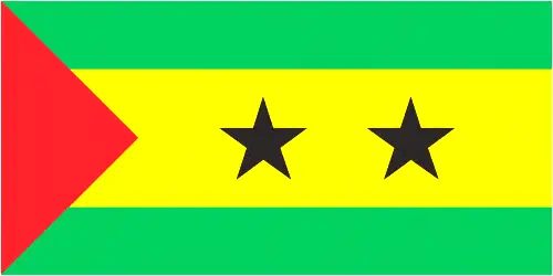
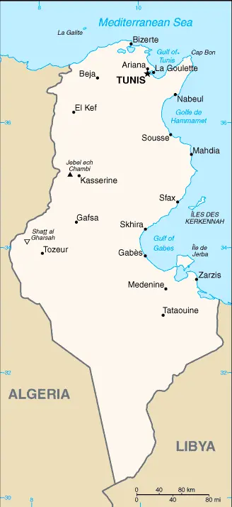
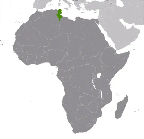
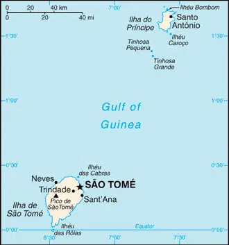
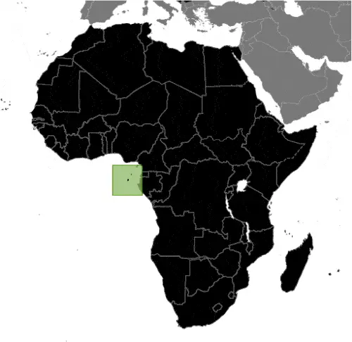
Borderline map of Sao Tome and Principe Location map of Sao Tome and Principe Flag of São Tomé and Principe

São Tomé and Principe Google map

Google Maps and Detailed Facts of Sao Tome and Principe (ST). This page lets you explore Sao Tome and Principe and its border countries (Country Location: Central Africa, islands in the Gulf of Guinea, just north of the Equator, west of Gabon) through detailed Satellite imagery – fast and easy as never before Google Maps.

Find comprehensive information about this country’s diversity below: Google maps, geography, economy, science, people, culture, environment, government, and history – All in One Wiki page.

There is also a Street View and free Driving Directions at your service. Your Google Satellite Map Sightseeing in Sao Tome and Principe starts here at Driving Directions and Maps.com in Africa.

Read more

Google Maps™ driving directions home » Africa

Tunisia Google Map

This image shows the draft map of Tunisia, Africa. For more details of the map of Tunisia, please see this page below. This image shows the location of Tunisia, Africa. For more geographical details of Tunisia, please see this page below. This image shows the flag of Tunisia, Africa. For more details of the flag of Tunisia, please see this page below.
Borderline map of Tunisia Location map of Tunisia Flag of Tunisia

Tunisia Google map

Google Maps and Detailed Facts of Tunisia (TN). This page lets you explore Tunisia and its border countries (Country Location: Northern Africa, bordering the Mediterranean Sea, between Algeria and Libya) through detailed Satellite imagery – fast and easy as never before Google Maps.

Find comprehensive information about this country’s diversity below: Google maps, geography, economy, science, people, culture, environment, government, and history – All in One Wiki page.

There is also a Street View and free Driving Directions at your service. Your Google Satellite Map Sightseeing in Tunisia, in Africa, starts here at Driving Directions and Maps.com.

Read more

Google Maps™ driving directions home » Africa

Seychelles Google Map

This image shows the draft map of Seychelles, Africa. For more details of the map of Seychelles, please see this page below. This image shows the location of Seychelles, Africa. For more geographical details of Seychelles, please see this page below. This image shows the flag of Seychelles, Africa. For more details of the flag of Seychelles, please see this page below.
Borderline map of Seychelles Location map of Seychelles Flag of Seychelles

Seychelles Google map

Google Maps and Detailed Facts of Seychelles (SC). This page lets you explore Seychelles and its border countries (Country Location: archipelago in the Indian Ocean, northeast of Madagascar) through detailed Satellite imagery – fast and easy as never before Google Maps.

Find comprehensive information about this country’s diversity below: Google maps, geography, economy, science, people, culture, environment, government, and history – All in One Wiki page.

There is also a Street View and free Driving Directions at your service. Your Google Satellite Map Sightseeing in Seychelles, in Africa, starts here at Driving Directions and Maps.com.

Read more

Google Maps™ driving directions home » Africa

South Africa Google Map

This image shows the draft map of South Africa, Africa. For more details of the map of South Africa, please see this page below. This image shows the location of South Africa, Africa. For more geographical details of South Africa, please see this page below. This image shows the flag of South Africa, Africa. For more details of the flag of South Africa, please see this page below.
Borderline map of South Africa Location map of South Africa Flag of South Africa

South Africa Google map

Google Maps and Detailed Facts of South Africa (ZA). This page lets you explore South Africa and its border countries (Country Location: Southern Africa, at the southern tip of the continent of Africa) through detailed Satellite imagery – fast and easy as never before Google Maps.

Find comprehensive information about this country’s diversity below: Google maps, geography, economy, science, people, culture, environment, government, and history – All in One Wiki page.

There is also a Street View and free Driving Directions at your service. Your Google Satellite Map Sightseeing in South Africa, Africa, starts here at Driving Directions and Maps.com.

Read more

Google Maps™ driving directions home » Africa

Senegal Google Map

This image shows the draft map of Senegal, Africa. For more details of the map of Senegal, please see this page below. This image shows the location of Senegal, Africa. For more geographical details of Senegal, please see this page below. This image shows the flag of Senegal, Africa. For more details of the flag of Senegal, please see this page below.
Borderline map of Senegal Location map of Senegal Flag of Senegal

Senegal Google map

Google Maps and Detailed Facts of Senegal (SN). This page lets you explore Senegal and its border countries (Country Location: Western Africa, bordering the North Atlantic Ocean, between Guinea-Bissau and Mauritania) through detailed Satellite imagery – fast and easy as never before Google Maps.

Find comprehensive information about this country’s diversity below: Google maps, geography, economy, science, people, culture, environment, government, and history – All in One Wiki page.

There is also a Street View and free Driving Directions at your service. Your Google Satellite Map Sightseeing in Senegal, in Africa, starts here at Driving Directions and Maps.com.

Read more

Google Maps™ driving directions home » Africa

Saint Helena Google Map

This image shows the draft map of Saint Helena, Africa. For more details of the map of Saint Helena, please see this page below. This image shows the location of Saint Helena, Africa. For more geographical details of Saint Helena, please see this page below. This image shows the flag of Saint Helena, Africa. For more details of the flag of Saint Helena, please see this page below.
Borderline map of Saint Helena Location map of Saint Helena Flag of Saint Helena

Saint Helena Google map

Google Maps and Detailed Facts of Saint Helena (SH). This page lets you explore Saint Helena and its border countries (Country Location: islands in the South Atlantic Ocean, about midway between South America and Africa; Ascension Island lies 1,300 km (800 mi) northwest of Saint Helena; Tristan da Cunha lies 4,300 km (2,700 mi) southwest of Saint Helena) through detailed Satellite imagery – fast and easy as never before Google Maps.

Find comprehensive information about this country’s diversity below: Google maps, geography, economy, science, people, culture, environment, government, and history – All in One Wiki page.

There is also a Street View and free Driving Directions at your service. Your Google Satellite Map Sightseeing in Saint Helena, in Africa, starts here at Driving Directions and Maps.com.

Read more

Google Maps™ driving directions home » Africa

Sierra Leone Google Map

This image shows the draft map of Sierra Leone, Africa. For more details of the map of Sierra Leone, please see this page below. This image shows the location of Sierra Leone, Africa. For more geographical details of Sierra Leone, please see this page below. This image shows the flag of Sierra Leone, Africa. For more details of the flag of Sierra Leone, please see this page below.
Borderline map of Sierra Leone Location map of Sierra Leone Flag of Sierra Leone

Sierra Leone Google map

Google Maps and Detailed Facts of Sierra Leone (SL). This page lets you explore Sierra Leone and its border countries (Country Location: Western Africa, bordering the North Atlantic Ocean, between Guinea and Liberia) through detailed Satellite imagery – fast and easy as never before Google Maps.

Find comprehensive information about this country’s diversity below: Google maps, geography, economy, science, people, culture, environment, government, and history – All in One Wiki page.

There is also a Street View and free Driving Directions at your service. In Africa, your Google Satellite Map Sightseeing in Sierra Leone starts here at Driving Directions and Maps.com.

Read more