
 |
 |
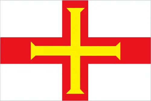 |
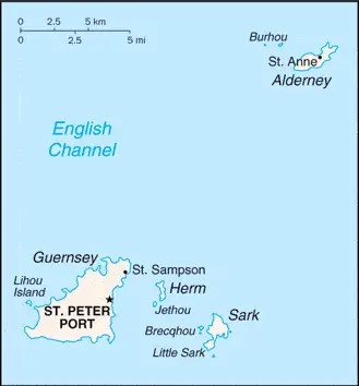
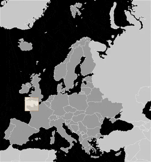
| Borderline map of Guernsey | Location map of Guernsey | Flag of Guernsey |
Google Maps and Detailed Facts of Guernsey (GG). This page lets you explore Guernsey and its border countries (Country Location: Western Europe, islands in the English Channel, northwest of France) through detailed Satellite imagery – fast and easy as never before Google Maps.
Find comprehensive information about this country’s diversity below: Google Maps, geography, economy, science, people, culture, environment, government, and history – All in One Wiki page.
There is also a Street View and free Driving Directions at your service. Your Google Satellite Map Sightseeing in Guernsey, in Europe, starts here at Driving Directions and Maps.com.
Guernsey Google Maps & Satellite Maps
The map below shows Guernsey with its cities, towns, highways, main roads, streets, and Street Views. To find a location, use the form below, type any city or place, view a simple map, and click the “show map” button.
The Google Maps above shows Guernsey with its location: Europe (geographic coordinates: 49 28 N, 2 35 W) and the international borders of Guernsey; 0 km; furthermore, it’s inland counties boundaries.
Hint: Look at the Street view in Guernsey, or Europe. All you have to do is drag and pull the little yellow man (named: Pegman) on the Google Maps above the desired location. After that, whenever it is available (more than 50 countries globally), blue stripes will appear to show the photos and details from Google’s regularly updated data image base. In case if you have signed in to your Google account currently, you may have a look at the satellite map of this country/area as well.
The map of Guernsey, Europe, is for informational use only. No representation is made or warrantied given any map or its content by Driving Directions and Maps site. The user assumes all risks of using this Guernsey Google Maps and facts/wiki.
About Guernsey in detail
Where is Guernsey?
Guernsey, in case, if you are looking on the map under the Coordinates 49 27 N 2 32 W otherwise in Europe, in Western Europe, islands in the English Channel, northwest of France.
What is the capital city of Guernsey?
The capital city of Guernsey is Saint Peter Port.
What is the time in Saint Peter Port?
It is 5 hours ahead of Washington, D.C. during Standard Time; Saint Peter Port’s timezone is UTC 0.
What is the Internet code for Guernsey?
The Top Level Domain (TLD) for Guernsey is: .gg
What is the size of Guernsey?
Guernsey’s territory is 78 sq km; land: 78 sq km, water: 0 sq km.
If we want to describe the size of Guernsey’s territory is about one-half the size of Washington, DC.
If we would like to walk around and discover Guernsey, we can cover a distance of 0 km.
What is the water coverage of Guernsey?
We have already mentioned what percentage of Guernsey is covered by water (see below), including a 50 km coastline.
What is the climate like in Guernsey?
Guernsey’s climate is temperate with mild winters and cool summers: about 50% of days are overcast.
Geographical data of Guernsey
Guernsey’s elevation; mean elevation: N/A, elevation extremes; lowest point: Atlantic Ocean 0 m, highest point: the unnamed elevation on Sark 114 m.
The specific geographical details of Guernsey include mostly flat with low hills in the southwest.
Suppose we would like to describe the countries location from a different perspective. In that case, it is safe to say, and easy to read from a map, Guernsey is a large, deepwater harbor at Saint Peter Port.
Resources and land use of Guernsey
The country’s main mined products are cropland. The population partly uses the earlier highlighted land territory and partly left in its natural state: N/A.
Population data of Guernsey
The number of inhabitants of Guernsey is 66,297 (July 2016 estimate).
If we examine the proportion of the population distribution, it is safe to say that N/A.
If we look at the proportion of the urbanized and barely populated areas, these are the figures: urban population: 31.4% of the total population (2014).
Most of the population in Guernsey is concentrated in N/A.
Ethnicity in Guernsey
According to ethnicity details, the ethnic groups are of British and Norman-French descent with small percentages from other European countries.
Spoken languages in Guernsey
Guernsey’s spoken languages are the following: English, French, Norman-French dialect spoken in country districts.
What are the most important religions in Guernsey?
According to this, during the general census, researchers examine the churches: Protestant (Anglican, Presbyterian, Baptist, Congregational, Methodist), Roman Catholic.
Further population data of Guernsey
The proportion of gender and age tells a lot about the society as follows 0-14 years: 14.46% (male 4,956 / female 4,630) 15-24 years: 11.45% (male 3,877 / female 3,715) 25-54 years: 41.89% (male 14,009 / female 13,760) 55-64 years: 12.93% (male 4,267 / female 4,304) 65 years and over: 19.28% (male 5,797 / female 6,982) (2016 estimate). It also a significant factor in a society the population growth rate, which in the case of Guernsey is 0.32% (2016 estimate).
The population growth rate is based on two elements, the birth, and the death rate. In Guernsey the birth rate is 9.8 births / 1,000 population (2016 estimate), the death rate 8.9 deaths / 1,000 population (2016 estimate).
In this day and age in developed societies, the first child borns later compared to the previous centuries and decades, so childbearing is extended. In Guernsey, the average age of mothers at the first childbirth is N/A.
Although the children’s birth is postponed in the best-case scenario, the parents can still see their kids grow as life expectancy also extended. In the case of Guernsey, these figures are. With the introduction of modern medicine, vaccinations, and the proper hygienic conditions, the infant mortality rate is in a steep decline. The infant mortality statistics in Guernsey are the following: N/A. Relevant data is the budget of healthcare, which is in the case of this country is N/A.
Economic data of Guernsey
Suppose we would like to describe a country. We also have to mention its economy; Financial services account for about 40% of employment and about 55% of total income in this tiny, prosperous Channel Island economy. Tourism, manufacturing, and horticulture, mainly tomatoes and cut flowers, have been declining. Financial services, const.
GDP is a prominent figure, as all the relevant calculations and statistics are based on it. GDP in Guernsey is $2.742 billion (2005 estimate).
Another important indicator is the rate of GDP growth, which in Guernsey is 0.9% (2014 estimate), 1.2% (2013 estimate) 4.2% (2012 estimate).
These statistics affect the world economy; remember, in 2015, the Chinese real GDP growth rate was worse than expected; The world markets fall, and the Chinese stock exchange was temporally suspended.
A further major factor of a country’s economy, the GDP per capita. In Guernsey this is $52,300 (2014 estimate).
In the economy, the Trinity is in common places, such as agriculture, industry, and services.
What are the agricultural products Guernsey produces?
Guernsey’s main agricultural products are tomatoes, greenhouse flowers, sweet peppers, eggplant, fruit, Guernsey cattle.
Regarding the economy, the essential segments are tourism, banking. The crucial and regularly mentioned GDP is based on tourism, banking.
Drinking water source in Guernsey
It is essential to mention that – thanks to the infrastructure development– the rate of potable water N/A.
The average number of childbirth in Guernsey
In Guernsey, the average delivery number is 1.56 children born / woman (2016 estimate).
Population, median age, migration, and citizenship in Guernsey
The population’s average age is 43.6 years; male: 42.3 years, female: 44.8 years (2016 estimate). The age of adulthood varies in every country of the world. In Guernsey, it is 16 years of age, universal.
When we are experiencing an unprecedented scale of migration and globalization, it is an important factor in the number of new immigrants. In Guernsey is 2.2 migrant(s) / 1,000 population (2016 estimate). It is important to know how to apply for citizenship: see the United Kingdom.
Is Guernsey a safe destination? Healthcare services and infectious diseases in Guernsey
Many of the travelers are looking into the healthcare services and infectious diseases of their destinations. In Guernsey, the hospital beds’ density is N/A.
According to the WHO rating regarding contagious diseases in Guernsey: N/A.
However, HIV is not curable but maintainable. Let’s do not forget when the disease surfaced; it was a world threatening condition. Unfortunately, in some countries, it is still very high the number of infected patients and fatalities due to the disease.
In Guernsey, the number of HIV/AIDS deaths: N/A.
Regarding tourism obesity, not an important issue, but we have to mention health statistics, as it is the plague of the 20th and the 21st century. The rate of obese adults in Guernsey is N/A.
What are the natural hazards in Guernsey? Is there any?
The most known natural risk in Guernsey is N/A.
More interesting facts about Guernsey
A few words about the past, as every country and society, are connected to its history; Guernsey and the other Channel Islands represent the last remnants of Normandy’s medieval Dukedom, which held sway in both France and England. The islands were the only British soil occupied by German troops in World War II. Guernsey is a British crown dependency but is not part of the UK or the EU. However, the UK Government is constitutionally responsible for its defense and international representation.
In every nation’s memory, some cornerstones placed the country on the timeline of history. The date of declaration of independence of Guernsey: none (British crown dependency).
The flag and other symbols of Guernsey
The colors, symbols, and animals on the flag usually have a historical background or an important milestone or memory of the nation.
This case is not an exception either; white with the red cross of Saint George (patron saint of England) extending to the edges of the flag and a yellow equal-armed cross of William the Conqueror superimposed on Saint George cross; the red cross represents the old ties with England and the fact that Guernsey is a British Crown dependency; the gold cross is a replica of the one used by Duke William of Normandy at the Battle of Hastings.
Apart from the flag, the symbol of national unity is the national anthem. The anthem’s primary purpose is to share the nation’s core values, endeavors, and patriotic feelings.
National symbols of Guernsey: Guernsey cow, donkey; national colors: red, white, yellow.
Constitution of Guernsey
The existence of the nation is based on the constitution. Some constitutions knew worldwide, like the U.S. Constitution that was accepted on the 17th of September 1787, in Philadelphia, the United States of America’s Constitution.
It is not related to the declaration of independence that was stolen by Nicolas Cage in the movie National Treasure 🙂
What is the legal system of Guernsey?
Most of the time, the legal system of a country is the focus of lawyers. It is a common fact that there are two main approaches in the world, “the law in books” and “the law in action.”
In the Anglo-Saxon world, the practice is the “law in action,” while in the rest of the world, the law is based on Roman law, the “law in books.”
Guernsey’s legal system is a customary legal system based on Norman customary law and includes elements of the French civil code and English common law.
It was Aristotle who founded the Theory of 3 separations of powers. In his view, these are the council of public affairs, the magistrates, and the justice system. The age of enlightenment was the time when terminologies have defined the way we still use them. In most democratic countries, the three authorities separated from each other. In dictatorships, the rules usually interweaved in one hand.
About the legislative branch of Guernsey, we can highlight the following structures unicameral States of Deliberation (40 seats; 38 People’s Deputies and two representatives of the States of Alderney; members directly elected by majority vote to serve 4-year terms); note – non-voting members include the bailiff (presiding officer), attorney-general, and solicitor-general.
About the unemployment rate, labor force, and poverty line in Guernsey
One of the major problems of the 21st-century economy is unemployment. Governments are struggling to maintain a low level of the unemployment rate. Still, as a result of automation, the cheap 3rd world labor, and the outsourcing of workflow, these attempts fail. In Guernsey, the labor force is 31,470 (March 2006). Please bear in mind that the population in Guernsey is total: 3.4 deaths / 1,000 live births; male: 3.7 deaths / 1,000 live births, female: 3.1 deaths / 1,000 live births (2016 estimate) – as we already mentioned above.
The rate of unemployment in Guernsey is 0.9% (March 2006 estimate).
Widely known that the gap between the rich and poor is widening on an enormous scale.
According to the 2017 shocking Oxfam report, the most affluent eight people’s fortune is equal to the wealth of the poorest half of the world’s population.
In Guernsey, the households’ income and consumption compared to the entire population: lowest 10%: N/A% highest 10%: N/A%.
Another widely used indicator is the so-called GINI index, which measures the inequalities of statistical dispersion, but is mainly used for measuring the sharing of income and fortune.
The GINI index was named after its founder Corrado Gini, an Italian economist. Gini index has grades between 0-1, but often it is used on a percentage basis. It is 0 if the examined criteria territorial distribution is equal. It is one of the criteria concentrated on the territory. In Guernsey, the GINI index is N/A.
The states usually set up a poverty line, which is more or less, is a subjective measure. It varies by country; its base is often the minimum pension, the incomes of the most deficient 20 percent, the X percent of income per capita Etc.
In Guernsey, the poverty line people are the lowest 10%: N/A% highest 10%: N/A%.
About the budget and central governments debt of Guernsey
The available budget mainly defines the state’s economy. Guernsey’s budget is; revenues: $563.6 million, expenditures: $530.9 million (2005). Taxes and other revenues are 20.6% of GDP (2005).
The budget deficit (Budget surplus (+) or deficit (-)) is N/A.
The fiscal year in Guernsey is the calendar year.
In the country’s economy, we have to consider the public debt. Public debt is the consolidated sum of the state’s local, federal, and central government debt.
Inflation rate and prime lending rate in Guernsey
A few further interesting and relevant economic data are the following; Inflation rate: 3.4% (June 2006 estimate) and the commercial bank prime lending rate: N/A.
Export/import partners and data of Guernsey
Guernsey, with the export of products, industrial tools, and other services, generates revenue. The export value in Guernsey is $ N/A. The total revenue of these activities: tomatoes, flowers, and ferns, sweet peppers, eggplant, other vegetables.
The most important export partners of Guernsey are N/A.
The most important imported products are coal, gasoline, oil, machinery, equipment, and the countries where the import is coming: N/A.
Renewable energies used in Guernsey
To suppress the pollution of the environment, renewable energies have to replace the fossil energy. The more the proportion of renewable energies in a country means more effort against pollution. Guernsey indicates how much of the country’s produced energy is coming from the hydroelectric source, N/A.
To indicate how much another renewable energy produced is N/A.
Telecommunication data of Guernsey, calling code
To maintain the economy, the development of a reliable and modern telecommunications infrastructure is crucial. We can say the following about Guernsey; Domestic: fixed-line and mobile-cellular services widely available. International: country code – 44; 1 submarine cable (2015).
Transport infrastructure in Guernsey
In the 21st century, we often say that the world has become small and there are no distances anymore. With widespread air travel when (sometimes) there are no visa restrictions, it is easy to reach other countries, but if the distance is not too long, we can also use railway or water transportation.
The number of airports in Guernsey: 2 (2013), and the number of heliports: N/A.
The total length of the roadways in Guernsey: N/A.
The total length of the waterways in Guernsey: N/A.
Are you traveling to Guernsey?
If you plan to travel by plane to Guernsey, try our air ticket comparison site, where you can choose from hundreds of carriers and offers. Our application is scanning the market and shows you the best and the cheapest deals without any extra charge or commission.
Are you looking for a hotel, apartment another kind of accommodation in Guernsey, Europe? We are here to help you to find your accommodation from budget to luxury. Our search engine is scanning, regularly updating data from hundreds of accommodation websites and more than a million offers. You can quickly and easily find your hotel stay anywhere in the world, without any extra charge or commission.
Facts & data about Guernsey
Name of the country: conventional long way: Bailiwick of Guernsey, traditional short form: Guernsey, etymology: the name is of Old Norse origin, but the meaning of the root “Guern(s)” is uncertain; the “-ey” ending means “island.”
| Abbreviation: Guernsey | Geographic coordinates: 49 28 N, 2 35 W |
Country Location: Europe |
| Capital of Guernsey: Saint Peter Port | GPS of the Capital: 49 27 N 2 32 W |
Position: Western Europe, islands in the English Channel, northwest of France |
| Land area: total: 78 sq km; land: 78 sq km, water: 0 sq km | Terrain: mostly flat with low hills in southwest |
Area comparative: about one-half the size of Washington, DC |
| Population: 66,297 (July 2016 estimate) | Population grow rate: 0.32% (2016 estimate) | Sex ratio: at birth: 1.05 male(s) / female, 0-14 years: 1.07 male(s) / female, 15-24 years: 1.04 male(s) / female, 25-54 years: 1.02 male(s) / female, 55-64 years: 0.99 male(s) / female, 65 years and over: 0.83 male(s) / female, total population: 0.99 male(s) / female (2016 estimate) |
| Exports: $ N/A | Imports: $NA | Import partners: N/A |
| Urbanization: urban population: 31.4% of the total population (2014). | Major urban area(s): N/A | Median age: total: 43.6 years; male: 42.3 years, female: 44.8 years (2016 estimate) |
| Internet users: total: 55,050. Percent of the population: 83.3% (July 2015 estimate) | Telephones (fixed-lines): total subscriptions: 45,100. Subscriptions per 100 inhabitants: 69 (July 2010 estimate) | Telephones (mobile, cellular): total: 67,500. Subscriptions per 100 inhabitants: 103 (July 2013 estimate) |
| Unemployment rate: 0.9% (March 2006 estimate) | Nationality: Channel Islander(s) adjective: Channel Islander | National holidays: Liberation Day, 9 May (1945) |
| Life expectancy at birth: total population: 82.5 years. Male: 79.9 years, female: 85.4 years (2016 estimate) | Total fertility rate: 1.56 children born / woman (2016 estimate) | Birthrate: 9.8 births / 1,000 population (2016 estimate) |
| Literacy: N/A | Legal system: a customary legal system based on Norman customary law, and includes elements of the French civil code and English common law | Suffrage: 16 years of age, universal |
| Industries: tourism, banking | Industrial production growth rate: N/A % | GDP real growth rate: 0.9% (2014 estimate) 1.2% (2013 estimate) 4.2% (2012 estimate) |
Do you like this Guernsey Google Maps & country information page?
Please do us a favor: Share or like this page using the icons at the top of the page. We also do encourage you to visit our Facebook page for more travel and country related information.
Many thanks for visiting and sharing this map & country information site!