
 |
 |
 |
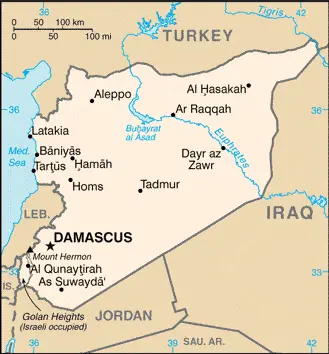
| Borderline map of Syria | Location map of Syria | Flag of Syria |
Google Maps and Detailed Facts of Syria (SY). This page lets you explore Syria and its border countries (Country Location: the Middle East, bordering the Mediterranean Sea, between Lebanon and Turkey) through detailed Satellite imagery – fast and easy as never before Google Maps.
Find comprehensive information about this country’s diversity below: Google maps, geography, economy, science, people, culture, environment, government, and history – All in One Wiki page.
There is also a Street View and free Driving Directions at your service. Your Google Satellite Map Sightseeing in Syria starts here at Driving Directions and Maps.com in the Middle East.
Syria Google Maps & Satellite Maps
The map below shows Syria’s cities, towns, highways, main roads, streets, and Street Views. To find a location, use the form below, type any city or place, view a simple map, and click the “show map” button.
The Google map above shows Syria with its location: Middle East (geographic coordinates: 35 00 N, 38 00 E) and the international borders of Syria; total: 2,363 km. Border countries (total: 5): Iraq 599 km, Israel 83 km, Jordan 379 km, Lebanon 403 km, Turkey 899 km; furthermore, it’s inland counties boundaries.
Hint: Look at the Street view in Syria or the Middle East. All you have to do is drag and pull the little yellow man (named: Pegman) on the Google map above the desired location. After that, whenever it is available (more than 50 countries globally), blue stripes will appear to show the photos and details from Google’s regularly updated data image base. In case if you have signed in to your Google account currently, you may have a look at the satellite map of this country/area as well.
The map of Syria, the Middle East is for informational use only. No representation is made or warrantied given any map or its content by Driving Directions and Maps site. The user assumes all risks of using this Syria Google map and facts/wiki.
About Syria in detail
Where is Syria?
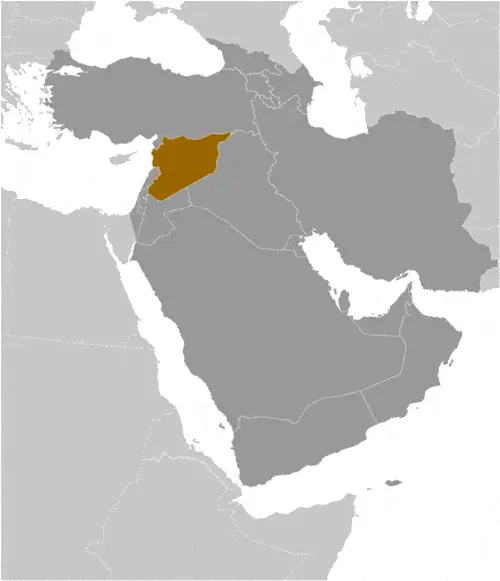
Syria is looking on the map under the Coordinates 33 30 N 36 18 E otherwise in the Middle East, bordering the Mediterranean Sea, between Lebanon and Turkey.
What is the capital city of Syria?
The capital city of Syria is Damascus.
What is the time in Damascus?
It is 7 hours ahead of Washington, D.C. during Standard Time; Damascus’s timezone is UTC+2.
What is the Internet code for Syria?
The Top Level Domain (TLD) for Syria is: .sy
What is the size of Syria?
The territory of Syria is total: 185,180 sq km; land: 183,630 sq km, water: 1,550 sq km.
If we want to describe the size of Syria’s territory is slightly more than 1.5 times the size of Pennsylvania.
If we would like to walk around and discover Syria, we can cover a total distance: 2,363 km.
What is the water coverage of Syria?
We have already mentioned what percentage of Syria is covered by water (see below), including a 193 km coastline.
What is the climate like in Syria?
Syria’s climate is mostly desert: hot, dry, sunny summers (June to August) and mild, rainy winters (December to February) along the coast: cold weather with snow or sleet periodically in Damascus.
Geographical data of Syria
The elevation of Syria; mean elevation: 514 m, elevation extremes; lowest point: unnamed location near Lake Tiberias -200 m, highest point: Mount Hermon 2,814 m.
Syria’s specific geographical details include primarily semiarid and desert plateau; narrow coastal plain; mountains in the west.
Suppose we would like to describe the countries location from a different perspective. In that case, it is safe to say, and easy to read from a map, Syria is the capital of Damascus – located at an oasis fed by the Barada River – is thought to be one of the world’s oldest continuously inhabited cities; there are 42 Israeli settlements and civilian land use sites in the Israeli-occupied Golan Heights (2014 estimate).
Resources and land use of Syria
The country’s main mined products are petroleum, phosphates, chrome and manganese ores, asphalt, iron ore, rock salt, marble, gypsum, hydropower. The population partly uses the earlier highlighted land territory and partly left in its natural state: agricultural land: 75.8%; arable land 25.4%; permanent crops 5.8%; permanent pasture 44.6%; forest: 2.7%; other: 21.5% (2011 estimate).
Population data of Syria
The number of inhabitants of Syria is 17,185,170 (July 2016 estimate).
If we examine the proportion of the population distribution, it is safe to say that significant population density along the Mediterranean coast; larger concentrations found in the major cities of Damascus, Aleppo (the country’s largest city), and Hims (Homs); more than half of the population lives in the coastal plain, the province of Aleppo, and the Euphrates River valley.
If we look at the proportion of the urbanized and barely populated areas, these are the figures: urban population: 57.7% of the total population (2015).
Most of the population in Syria is concentrated in Aleppo 3.562 million; DAMASCUS (capital) 2.566 million; Hims (Homs) 1.641 million; Hamah 1.237 million; Lattakia 781,000 (2015).
Ethnicity in Syria
According to ethnicity details, the ethnic groups are Arab 90.3%, Kurdish, Armenian, and 9.7%.
Spoken languages in Syria
The spoken languages in Syria are the following: Arabic (official language), Kurdish, Armenian, Aramaic, Circassian, French, English.
What are the most important religions in Syria?
During the general census, researchers examine the churches, according to this: Muslim 87% (official; includes Sunni 74% and Alawi, Ismaili, and Shia 13%), Christian 10% (includes Orthodox, Uniate, and Nestorian), Druze 3%, Jewish (few remaining in Damascus and Aleppo).
Further population data of Syria
The proportion of gender and age tells a lot about the society as follows 0-14 years: 31.95% (male 2,815,140 / female 2,675,166) 15-24 years: 19.65% (male 1,711,847 / female 1,664,814) 25-54 years: 39.03% (male 3,342,264 / female 3,364,406) 55-64 years: 5.26% (male 447,205 / female 457,525) 65 years and over: 4.11% (male 318,691 / female 388,112) (2016 estimate). It also a significant factor in a society the population growth rate, which in the case of Syria is 1.56% (2016 estimate).
The population growth rate is based on two elements, the birth, and the death rate. In Syria the birth rate is 21.7 births / 1,000 population (2016 estimate), the death rate 4 deaths / 1,000 population (2016 estimate).
In this day and age in developed societies, the first child borns later compared to the previous centuries and decades, so childbearing is extended. In Syria, the average age of mothers at the first childbirth is N/A.
Although the children’s birth is postponed in the best-case scenario, the parents can still see their kids grow as life expectancy also extended. In the case of Syria, these figures are. With the introduction of modern medicine, vaccinations, and the proper hygienic conditions, the infant mortality rate is in a steep decline. The infant mortality statistics in Syria are the following: N/A. Relevant data is the budget of healthcare, which is in this country’s case is 3.3% of GDP (2014).
Economic data of Syria
Suppose we would like to describe a country. We also have to mention its economy; Syria’s economy continues to deteriorate amid the ongoing conflict that began in 2011, declining by more than 70% from 2010 to 2016. The government has struggled to address the effects of international sanctions. During 2014, the ongoing conflict and continued unrest and economic decline worsened the humanitarian crisis. They elicited a greater need for international assistance, as the number of people in need inside Syria increased from 9.3 million to 12.2 million. Before the turmoil, Damascus had begun liberalizing economic policies, including cutting lending interest rates, opening private banks, consolidating multiple exchange rates, raising prices on some subsidized items, and establishing the Damascus Stock Exchange.
GDP is a prominent figure, as all the relevant calculations and statistics are based on it. GDP in Syria is $24.6 billion (2014 estimate).
Another important indicator is the rate of GDP growth, which in Syria is -9.9% (2015 estimate) -36.5% (2014 estimate) -30.9% (2013 estimate).
These statistics affect the world economy; remember, in 2015, the Chinese real GDP growth rate was worse than expected; The world markets fall, and the Chinese stock exchange was temporarily suspended.
A further major factor of a country’s economy, the GDP per capita. In Syria this is $2,900 (2015 estimate)NA (2013 estimate)NA (2010 estimate).
In the economy, the Trinity is in common places, such as agriculture, industry, and services.
What are the agricultural products Syria produces?
Syria’s main agricultural products are wheat, barley, cotton, lentils, chickpeas, olives, sugar beets, beef, mutton, eggs, poultry, milk.
The essential segments are petroleum, textiles, food processing, beverages, tobacco, phosphate rock mining, cement, oil seeds crushing, and automobile assembly. The crucial and regularly mentioned GDP is based on petroleum, textiles, food processing, beverages, tobacco, phosphate rock mining, cement, oil seeds crushing, automobile assembly.
Drinking water source in Syria
It is essential to mention that – thanks to the development of the infrastructure -, the rate of potable water improved: urban: 92.3% of the population, rural: 87.2% of the population, total: 90.1% of the population. Unimproved: urban: 7.7% of the people, rural: 12.8% of the population, total: 9.9% of the population (2015 estimate).
The average number of childbirth in Syria
In Syria, the average delivery number is 2.55 children born / woman (2016 estimate).
Population, median age, migration, and citizenship in Syria
The population’s average age is 24.1 years; male: 23.7 years, female: 24.6 years (2016 estimate). The age of adulthood varies in every country of the world in Syria; it is 18 years of age, universal.
When we are experiencing an unprecedented scale of migration and globalization, it is an important factor in the number of new immigrants. In Syria is -2.1 migrant(s) / 1,000 population (2016 estimate). It is important to know how to apply for citizenship: citizenship by birth: no. Citizenship by descent only: the father must be a citizen of Syria; if the father is unknown or stateless, the mother must be a citizen of Syria. Dual citizenship recognized: yes, the residency requirement for naturalization: 10 years.
Is Syria a safe destination? Healthcare services and infectious diseases in Syria
Many of the travelers are looking into the healthcare services and infectious diseases of their destinations. In Syria, the hospital beds’ density is 1.5 beds / 1,000 population (2012).
According to the WHO rating regarding contagious diseases in Syria: N/A.
However, HIV is not curable but maintainable. Let’s do not forget when the disease surfaced; it was a world threatening condition. Unfortunately, in some countries, it is still very high the number of infected patients and fatalities due to the disease.
In Syria, the number of HIV/AIDS deaths: N/A.
Regarding tourism obesity, not an important issue, but we have to mention health statistics, as it is the plague of the 20th and the 21st century. The rate of obese adults in Syria is 21.6% (2014).
What are the natural hazards in Syria? Is there any?
The most known natural risk in Syria is dust storms, sandstorms. Volcanism: Syria’s two historically active volcanoes, Es Safa and an unnamed volcano near the Turkish border, have not erupted in centuries.
More interesting facts about Syria
A few words about the past, as every country and society is connected to its history; Following World War I, France acquired a mandate over the northern portion of the former Ottoman Empire province of Syria. The French administered the area as Syria until granting it independence in 1946. The new country lacked political stability and experienced a series of military coups. Syria united with Egypt in February 1958 to form the United Arab Republic. In September 1961, the two entities separated, and the Syrian Arab Republic was reestablished. In the 1967 Arab-Israeli War, Syria lost the Golan Heights region to Israel. During the 1990s, Syria and Israel held occasional, albeit unsuccessful, peace talks over its return. In November 1970, Hafiz al-ASAD, a member of the socialist Ba’th Party and the minority Alawi sect, seized power in a bloodless coup and brought political stability to the country. Following President Hafiz al-Assad’s death, his son, Bashar al-ASAD, was approved as president by a popular referendum in July 2000. Syrian troops – stationed in Lebanon since 1976 in an ostensible peacekeeping role – were withdrawn in April 2005. During the July-August 2006 conflict between Israel and Hizballah, Syria placed its military forces on alert but did not intervene directly on behalf of its ally Hizballah. In May 2007, Bashar al-ASAD’s second term as president was approved by a popular referendum. Influenced by major uprisings that began elsewhere in the region, and compounded by additional social and economic factors, anti-government protests broke out first in the southern province of Dar’a in March 2011 with protesters calling for the repeal of the restrictive Emergency Law allowing arrests without charge, the legalization of political parties, and the removal of corrupt local officials. Demonstrations and violent unrest spread across Syria, with the size and intensity of protests fluctuating.
The government responded to unrest with a mix of concessions, including the Emergency Law’s repeal, new laws permitting new political parties, and liberalizing local and national elections – and military force. However, the government’s response has failed to meet opposition demands for ASAD’s resignation. The government’s ongoing violence to quell unrest and widespread armed opposition activity has led to extended clashes between government forces and oppositionists. International pressure on the ASAD regime has intensified since late 2011, as the Arab League, EU, Turkey, and the US expanded economic sanctions against the regime. In December 2012, the Syrian National Coalition was recognized by more than 130 countries as the sole legitimate representative of the Syrian people. Peace talks between the Coalition and Syrian regime at the UN-sponsored Geneva II conference in 2014 and the UN-sponsored Geneva III talks in 2016 failed to produce a resolution of the conflict. Unrest continues in Syria, and according to an April 2016 UN estimate, the death toll among Syrian Government forces, opposition forces, and civilians had reached 400,000. As of December 2016, approximately 13.5 million people needed humanitarian assistance in Syria, with 6.3 million people displaced internally and an additional 4.8 million Syrian refugees, making the Syrian situation the largest humanitarian crisis worldwide.
In every nation’s memory, some cornerstones placed the country on the timeline of history. The date of declaration of independence of Syria: 17 April 1946 (from League of Nations mandate under French administration).
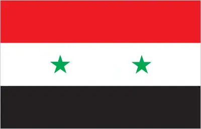
The flag and other symbols of Syria
The colors, symbols, and animals on the flag usually have a historical background or an important milestone or memory of the nation.
This case is not an exception either; three equal horizontal bands of red (top), white, and black; two small, green, five-pointed stars in a horizontal line centered in the white band; the band colors derive from the Arab Liberation flag and represent oppression (black), overcome through bloody struggle (red), to be replaced by a bright future (white); identical to the former flag of the United Arab Republic (1958-1961) where the two stars represented the constituent states of Syria and Egypt; the current design dates to 1980note: similar to the flag of Yemen, which has a plain white band, Iraq, which has an Arabic inscription centered in the white band, and that of Egypt, which has a gold Eagle of Saladin centered in the white band.
Apart from the flag, the symbol of national unity is the national anthem. The anthem’s primary purpose is to share the nation’s core values, endeavors, and patriotic feelings.
National symbols of Syria: hawk; national colors: red, white, black, green.
Constitution of Syria
The existence of the nation is based on the constitution. Some constitutions knew worldwide, like the U.S. Constitution that was accepted on the 17th of September 1787, in Philadelphia, the United States of America’s Constitution.
It is not related to the declaration of independence that was stolen by Nicolas Cage in the movie National Treasure 🙂
What is the legal system of Syria?
Most of the time, the legal system of a country is the focus of lawyers. It is a common fact that there are two main approaches in the world, “the law in books” and “the law in action.”
In the Anglo-Saxon world, the practice is the “law in action,” while in the rest of the world, the law is based on Roman law, the “law in books.”
Syria’s legal system is a mixed legal system of civil and Islamic law (for family courts).
It was Aristotle who founded the Theory of 3 separations of powers. In his view, these are the council of public affairs, the magistrates, and the justice system. The age of enlightenment was the time when terminologies have defined the way we still use them. In most democratic countries, the three authorities separated from each other. In dictatorships, the rules usually interweaved in one hand.
We can highlight the following structures about Syria’s legislative branch: unicameral People’s Assembly or Majlis al-Shaab (250 seats; members directly elected in multi-seat constituencies by proportional representation vote to serve 4-year terms).
About the unemployment rate, labor force, and poverty line in Syria
One of the major problems of the 21st-century economy is unemployment. Governments are struggling to maintain a low level of the unemployment rate. Still, as a result of automation, the cheap 3rd world labor, and the outsourcing of workflow, these attempts fail. In Syria, the labor force is 3.37 million (2016 estimate). Please bear in mind that the population in Syria is total: 15.2 deaths / 1,000 live births; male: 17.5 deaths / 1,000 live births, female: 12.8 deaths / 1,000 live births (2016 estimate) – as we already mentioned above.
The rate of unemployment in Syria is 50% (2016 estimate).
Widely known that the gap between the rich and poor is widening on an enormous scale.
According to the 2017 shocking Oxfam report, the most affluent eight people’s fortune is equal to the wealth of the poorest half of the world’s population.
In Syria, the households’ income and consumption compared to the entire population: lowest 10%: N/A% highest 10%: N/A%.
Another widely used indicator is the so-called GINI index, which measures the inequalities of statistical dispersion, but is mainly used for measuring the sharing of income and fortune.
The GINI index was named after its founder Corrado Gini, an Italian economist. Gini index has grades between 0-1, but often it is used on a percentage basis. It is 0 if the examined criteria territorial distribution is equal. It is one of the criteria concentrated on the territory. In Syria, the GINI index is N/A.
The states usually set up a poverty line, which is more or less, is a subjective measure. It varies by country; its base is often the minimum pension, the incomes of the most deficient 20 percent, the X percent of income per capita Etc.
In Syria, the poverty line people are the lowest 10%: N/A% highest 10%: N/A%.
About the budget and central governments debt of Syria
The available budget mainly defines the state’s economy. The budget of Syria is; revenues: $494.5 million, expenditures: $2.665 billion. Note government projections for FY2016. Taxes and other revenues are 2% of GDP (2016 estimate).
The budget deficit (Budget surplus (+) or deficit (-)) is N/A.
The fiscal year in Syria is the calendar year.
In the country’s economy, we have to consider the public debt. Public debt is the consolidated sum of the state’s local, federal, and central government debt.
Inflation rate and prime lending rate in Syria
A few further interesting and relevant economic data are the following; Inflation rate: 47.7% (2016 estimate), 38.1% (2015 estimate), and the rate of the Commercial bank prime lending rate: 32% (31 December 2016 estimate).
Export/import partners and data of Syria
Syria, with the export of products, industrial tools, and other services, generates revenue. The export value in Syria is: $2.304 billion (2016 estimate), $2.14 billion (2015 estimate). The total revenue of these activities: crude oil, minerals, petroleum products, fruits and vegetables, cotton fiber, textiles, clothing, meat and live animals, wheat.
Syria’s most important export partners are Iraq 64.7%, Saudi Arabia 11.2%, Kuwait 7.1%, UAE 6.1%, Libya 4.6% (2015).
The most important imported products are machinery and transport equipment, electric power machinery, food and livestock, metal and metal products, chemicals and chemical products, plastics, yarn, paper, and the countries from where the import is coming: Saudi Arabia 28%, UAE 13.7%, Iran 10.1%, Turkey 9%, Iraq 8.3%, China 6.1% (2015).
Renewable energies used in Syria
To suppress the pollution of the environment, renewable energies have to replace the fossil energy. The more the proportion of renewable energies in a country means more effort against pollution. Syria, the indicator of how much of the country’s produced energy is coming from the hydroelectric source, is 16.8% of total installed capacity (2012 estimate).
To indicate how much another renewable energy produced is 0.3% of total installed capacity (2012 estimate).
Telecommunication data of Syria, calling code
To maintain the economy, the development of a reliable and modern telecommunications infrastructure is crucial. We can say the following about Syria; the armed insurgency that began in 2011 has led to significant disruptions to the network and has caused telephone and Internet outages throughout the country domestic: the number of fixed-line connections increased markedly before the civil war in 2011; mobile-cellular service stands at about 80 per 100 persons. International: country code – 963; submarine cable connection to Egypt, Lebanon, and Cyprus; satellite earth stations – 1 Intelsat (Indian Ocean) and 1 Intersputnik (Atlantic Ocean region); coaxial cable and microwave radio relay to Iraq, Jordan, Lebanon, and Turkey; pa (2015).
Transport infrastructure in Syria
In the 21st century, we often say that the world has become small and there are no distances anymore. With widespread air travel when (sometimes) there are no visa restrictions, it is easy to reach other countries, but if the distance is not too long, we can also use railway or water transportation.
The number of airports in Syria: 90 (2013), and the number of heliports: 6 (2013).
The total length of the roadways in Syria: 69,873 km, paved: 63,060 km, unpaved: 6,813 km (2010).
The total length of the waterways in Syria: 900 km (navigable but not economically significant) (2011).
Are you traveling to Syria?
If you plan to travel by plane to Syria, try our air ticket comparison site, where you can choose from hundreds of carriers and offers. Our application is scanning the market and shows you the best and the cheapest deals without any extra charge or commission.
Are you looking for a hotel, apartment another kind of accommodation in Syria, the Middle East? We are here to help you to find your accommodation from budget to luxury. Our search engine is scanning, regularly updating data from hundreds of accommodation websites and more than a million offers. You can quickly and easily find your hotel stay anywhere in the world, without any extra charge or commission.
Facts & data about Syria
Name of the country: conventional long way: the Syrian Arab Republic, traditional short form: Syria, local long form: Al Jumhuriyah al Arabiyah as Suriyah, local short state: Suriyah, former: United Arab Republic (with Egypt), etymology: name ultimately derived from the ancient Assyrians who dominated northern Mesopotamia, but whose reach also extended westward to the Levant; over time, the name came to be associated more with the western area.
| Abbreviation: Syria | Geographic coordinates: 35 00 N, 38 00 E |
Country Location: Middle East |
| Capital of Syria: Damascus | GPS of the Capital: 33 30 N 36 18 E |
Position: Middle East, bordering the Mediterranean Sea, between Lebanon and Turkey |
| Land area: total: 185,180 sq km; land: 183,630 sq km, water: 1,550 sq km | Terrain: primarily semiarid and desert plateau; narrow coastal plain; mountains in west |
Area comparative: slightly more than 1.5 times the size of Pennsylvania |
| Population: 17,185,170 (July 2016 estimate) | Population grow rate: 1.56% (2016 estimate) | Sex ratio: at birth: 1.06 male(s) / female, 0-14 years: 1.05 male(s) / female, 15-24 years: 1.03 male(s) / female, 25-54 years: 0.99 male(s) / female, 55-64 years: 0.98 male(s) / female, 65 years and over: 0.82 male(s) / female, total population: 1.01 male(s) / female (2016 estimate) |
| Exports: $2.304 billion (2016 estimate), $2.14 billion (2015 estimate) | Imports: $5.965 billion (2016 estimate), $6.663 billion (2015 estimate) | Import partners: Saudi Arabia 28%, UAE 13.7%, Iran 10.1%, Turkey 9%, Iraq 8.3%, China 6.1% (2015) |
| Urbanization: urban population: 57.7% of the total population (2015) | Major urban area(s): Aleppo 3.562 million; DAMASCUS (capital) 2.566 million; Hims (Homs) 1.641 million; Hamah 1.237 million; Lattakia 781,000 (2015) | Median age: total: 24.1 years; male: 23.7 years, female: 24.6 years (2016 estimate) |
| Internet users: total: 5.116 million. Percent of the population: 30% (July 2015 estimate) | Telephones (fixed-lines): total subscriptions: 4.082 million. Subscriptions per 100 inhabitants: 24 (July 2015 estimate) | Telephones (mobile, cellular): total: 13.904 million. Subscriptions per 100 inhabitants: 81 (July 2015 estimate) |
| Unemployment rate: 50% (2016 estimate) | Nationality: Syrian(s) adjective: Syrian | National holidays: Independence Day, 17 April (1946) |
| Life expectancy at birth: total population: 74.9 years. Male: 72.5 years, female: 77.4 years (2016 estimate) | Total fertility rate: 2.55 children born / woman (2016 estimate) | Birthrate: 21.7 births / 1,000 population (2016 estimate) |
| Literacy: age 15 and over can read and write. Total population: 86.4%; male: 91.7%, female: 81% (2015 estimate) | Legal system: mixed legal system of civil and Islamic law (for family courts) | Suffrage: 18 years of age, universal |
| Industries: petroleum, textiles, food processing, beverages, tobacco, phosphate rock mining, cement, oil seeds crushing, automobile assembly | Industrial production growth rate: -2.4% (2016 estimate) | GDP real growth rate: -9.9% (2015 estimate) -36.5% (2014 estimate) -30.9% (2013 estimate) |
Do you like this Syria Google maps™ & country information page?
Please do us a favor: Share or like this page using the icons at the top of the page. We also do encourage you to visit our Facebook page for more travel and country related information.
Many thanks for visiting and sharing this map & country information site!