
 |
 |
 |
| Borderline map of Tonga | Location map of Tonga | Flag of Tonga |
Google Maps and Detailed Facts of Tonga (TO). This page lets you explore Tonga and its border countries (Country Location: Oceania, an archipelago in the South Pacific Ocean, about two-thirds of the way from Hawaii to New Zealand) through detailed Satellite imagery – fast and easy as never before Google Maps.
Find comprehensive information about this country’s diversity below: Google Maps, geography, economy, science, people, culture, environment, government, and history – All in One Wiki page.
There is also a Street View and free Driving Directions at your service. Your Google Satellite Map Sightseeing in Tonga, in Oceania, starts here at Driving Directions and Maps.com.
Tonga Google Maps & Satellite Maps
The map below shows Tonga with its cities, towns, highways, main roads, streets, and Street Views. To find a location, use the form below, type any city or place, view a simple map, and click the “show map” button.
The Google Maps above shows Tonga with its location: Oceania (geographic coordinates: 20 00 S, 175 00 W) and the international borders of Tonga; 0 km; furthermore, it’s inland counties boundaries.
Hint: Look at the Street view in Tonga or Oceania. All you have to do is drag and pull the little yellow man (named: Pegman) on the Google Maps above the desired location. After that, whenever it is available (more than 50 countries globally), blue stripes will appear to show the photos and details from Google’s regularly updated data image base. In case if you have signed in to your Google account currently, you may have a look at the satellite map of this country/area as well.
The map of Tonga, Oceania, is for informational use only. No representation is made or warrantied given any map or its content by Driving Directions and Maps site. The user assumes all risks of using this Tonga Google Maps and facts/wiki.
About Tonga in detail
Where is Tonga?
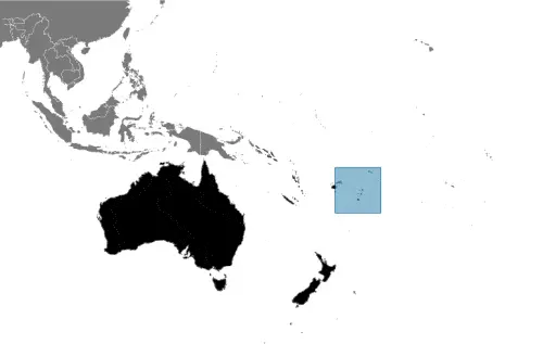
In case Tonga is looking on the map under the Coordinates 21 08 S 175 12 W otherwise in Oceania, an archipelago in the South Pacific Ocean, about two-thirds of the way from Hawaii to New Zealand.
What is the capital city of Tonga?
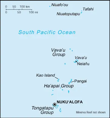
The capital city of Tonga is Nuku’alofa.
What is the time in Nuku’alofa?
It is 18 hours ahead of Washington, D.C. during Standard Time; the timezone of Nuku’alofa is UTC+13.
What is the Internet code for Tonga?
The Top Level Domain (TLD) for Tonga is: .to
What is the size of Tonga?
The territory of Tonga is total: 747 sq km; land: 717 sq km, water: 30 sq km.
If we want to describe the size of the territory of Tonga is four times the size of Washington, DC.
If we would like to walk around and discover Tonga, we can cover 0 km.
What is the water coverage of Tonga?
We have already mentioned what percentage of Tonga is covered by water (see below), and this includes 419 km coastline.
What is the climate like in Tonga?
The climate of Tonga is tropical: modified by trade winds: warm season (December to May), cool season (May to December).
Geographical data of Tonga
The elevation of Tonga; mean elevation: N/A, elevation extremes; lowest point: Pacific Ocean 0 m, highest point: the unnamed elevation on Kao Island 1,033 m.
The specific geographical details of Tonga include mostly flat islands with limestone bedrock formed from the uplifted coral formation; others have limestone overlying volcanic rock.
Suppose we would like to describe the countries location from a different perspective. In that case, it is safe to say, and easy to read from a map, Tonga is an archipelago of 169 islands (36 inhabited).
Resources and land use of Tonga
The country’s main mined products are fish, arable land. The population partly uses the earlier highlighted land territory and partly left in its natural state: agricultural land: 43.1%; arable land 22.2%; permanent crops 15.3%; permanent pasture 5.6%; forest: 12.5%; other: 44.4% (2011 estimate).
Population data of Tonga
The number of inhabitants of Tonga is 106,513 (July 2016 estimate).
If we examine the proportion of the population distribution, it is safe to say that N/A.
If we look at the proportion of the urbanized and barely populated areas, these are the figures: urban population: 23.7% of the total population (2015).
Most of the population in Tonga is concentrated in Nuku’alofa 25,000 (2014).
Ethnicity in Tonga
According to ethnicity details, the ethnic groups are Tongan 96.6%, part-Tongan 1.7%, other 1.7%, unspecified 0.03% (2006 estimate).
The spoken languages in Tonga are the following: English and Tongan 87%, Tongan (official language) 10.7%, English (official language) 1.2%, other 1.1%, unspecified 0.03% (2006 estimate).
What are the most important religions in Tonga?
During the general census, researchers examine the churches, according to this: Protestant 64.9% (includes Free Wesleyan Church 37.3%, Free Church of Tonga 11.4%, Church of Tonga 7.2%, Tokaikolo Christian Church 2.6%, Assembly of God 2.3%, Seventh Day Adventist 2.2%, Constitutional Church of Tonga 0.9%, Anglican 0.8%, and Full Gospel Church 0.2%), Mormon 16.8%, Roman Catholic 15.6%, other 1.1%, none 0.03%, unspecified 1.7% (2006 estimate).
Further population data of Tonga
The proportion of gender and age tells a lot about the society as follows 0-14 years: 34.47% (male 18,656 / female 18,061) 15-24 years: 19.57% (male 10,671 / female 10,169) 25-54 years: 33.92% (male 18,045 / female 18,080) 55-64 years: 5.7% (male 3,000 / female 3,072) 65 years and over: 6.35% (male 3,064 / female 3,695) (2016 estimate). It also a significant factor in a society the population growth rate, which in the case of Tonga is -0.01% (2016 estimate).
The population growth rate is based on two elements, the birth, and the death rate. In Tonga the birth rate is 22.6 births / 1,000 population (2016 estimate), the death rate 4.9 deaths / 1,000 population (2016 estimate).
In this day and age in developed societies, the first child borns later compared to the previous centuries and decades, so childbearing is extended. In Tonga, the average age of mothers at the first childbirth is N/A.
Although the children’s birth is postponed in the best-case scenario, the parents can still see their kids grow as life expectancy also extended. In the case of Tonga, these figures are. With the introduction of modern medicine, vaccinations, and the proper hygienic conditions, the infant mortality rate is in a steep decline. The infant mortality statistics in Tonga are the following: N/A. Relevant data is the budget of healthcare, which is in the case of this country is 5.2% of GDP (2014).
Economic data of Tonga
Suppose we would like to describe a country. We also have to mention its economy; Tonga has a small, open, island economy and is the last constitutional monarchy among the Pacific Island countries. It has a narrow export base in agricultural goods. Squash, vanilla beans, and yams are the main crops. The country remains dependent on external aid and remittances from overseas Tongans to offset its trade deficit. The government emphasizes the development of the private sector, encouraging investment, and is committing increased funds for healthcareTonga has a reasonably sound basic infrastructure and well developed social services. The government faces high unemployment among the young, moderate inflation, pressures for democratic reform, and rising civil service expenditures.
GDP is a prominent figure, as all the relevant calculations and statistics are based on it. GDP in Tonga is $430 million (2015 estimate).
Another important indicator is the rate of GDP growth, which in Tonga is 2.7% (2016 estimate), 3.4% (2015 estimate) 2.9% (2014 estimate).
These statistics affect the world economy; remember, in 2015, the Chinese real GDP growth rate was worse than expected; The world markets fall, and the Chinese stock exchange was temporarily suspended.
A further major factor of a country’s economy, the GDP per capita. In Tonga this is $5,300 (2016 estimate) $5,200 (2015 estimate) $5,000 (2014 estimate).
In the economy, the Trinity is in common places, such as agriculture, industry, and services.
What are the agricultural products Tonga produces?
The main agricultural products of Tonga are squash, coconuts, copra, bananas, vanilla beans, cocoa, coffee, sweet potatoes, cassava, taro, and kava.
Regarding the economy, the essential segments are tourism, construction, fishing. The crucial and regularly mentioned GDP is based on tourism, construction, fishing.
Drinking water source in Tonga
It is essential to mention that – thanks to the development of the infrastructure -, the rate of potable water improved: urban: 99.7% of the population, rural: 99.6% of the population, total: 99.6% of the population. Unimproved: urban: 0.3% of the population, rural: 0.4% of the population, total: 0.4% of the population (2015 estimate).
The average number of childbirth in Tonga
In Tonga, the average delivery number is 3.18 children born / woman (2016 estimate).
Population, median age, migration, and citizenship in Tonga
The population’s average age is 22.6 years; male: 22.2 years, female: 23.1 years (2016 estimate). The age of adulthood varies in every country of the world. In Tonga, it is 21 years of age, universal.
When we are experiencing an unprecedented scale of migration and globalization, it is an important factor in the number of new immigrants. In Tonga is -17.8 migrant(s) / 1,000 population (2016 estimate). It is important to know how to apply for citizenship: citizenship by birth: no. Citizenship by descent only: the father must be a citizen of Tonga; if a child is born out of wedlock, the mother must be a Tonga citizen. Dual citizenship recognized: yes, the residency requirement for naturalization: 5 years.
Is Tonga a safe destination? Healthcare services and infectious diseases in Tonga
Many of the travelers are looking into the healthcare services and infectious diseases of their destinations. In Tonga, the hospital beds’ density is 2.6 beds / 1,000 population (2010).
According to the WHO rating regarding contagious diseases in Tonga the note: active local transmission of Zika virus by Aedes species mosquitoes has been identified in this country (as of August 2016); it poses a critical risk (a large number of cases possible) among US citizens if bitten by an infective mosquito; other less common ways to get Zika are through sex, via blood transfusion, or during pregnancy, in which the pregnant woman passes Zika virus to her fetus (2016).
However, HIV is not curable but maintainable. Let’s do not forget when the disease surfaced; it was a world threatening condition. Unfortunately, in some countries, it is still very high the number of infected patients and fatalities due to the disease.
In Tonga, the number of HIV/AIDS deaths: N/A.
Regarding tourism obesity, not an important issue, but we have to mention health statistics, as it is the plague of the 20th and the 21st century. The rate of obese adults in Tonga is 41.1% (2014).
What are the natural hazards in Tonga? Is there any?
The most known natural risk in Tonga are cyclones (October to April); earthquakes and volcanic activity on Fonuafo’ouvolcanism: moderate volcanic activity; Fonualei (elevation 180 m) has shown frequent activity in recent years, while Niuafo’ou (height 260 m), which last erupted in 1985, has forced evacuations; other historically active volcanoes include Late and Tofua.
More interesting facts about Tonga
Like every country and society, a few words about the past are connected to its history; Tonga – unique among Pacific nations – never completely lost its indigenous governance. The archipelagos of “The Friendly Islands” were united into a Polynesian kingdom in 1845. Tonga became a constitutional monarchy in 1875 and a British protectorate in 1900; it withdrew from the protectorate and joined the Commonwealth of Nations in 1970. Tonga remains the only monarchy in the Pacific.
In every nation’s memory, some cornerstones placed the country on the timeline of history. The date of declaration of independence of Tonga: 4 June 1970 (from UK protectorate).
The flag and other symbols of Tonga
The colors, symbols, and animals on the flag usually have a historical background or an important milestone or memory of the nation.
This case is not an exception either; red with a bold red cross on a white rectangle in the upper hoist-side corner; the cross reflects the deep-rooted Christianity in Tonga; red represents the blood of Christ and his sacrifice; white signifies purity.
Apart from the flag, the symbol of national unity is the national anthem. The anthem’s primary purpose is to share the nation’s core values, endeavors, and patriotic feelings.
Tonga’s national symbols: red cross on a white field, arms equal length; national colors: red, white.
Constitution of Tonga
The existence of the nation is based on the constitution. Some constitutions knew worldwide, like the U.S. Constitution that was accepted on the 17th of September 1787, in Philadelphia, the United States of America’s Constitution.
It is not related to the declaration of independence that was stolen by Nicolas Cage in the movie National Treasure 🙂
What is the legal system of Tonga?
Most of the time, the legal system of a country is the focus of lawyers. It is a common fact that there are two main approaches in the world, “the law in books” and “the law in action.”
In the Anglo-Saxon world, the practice is the “law in action,” while in the rest of the world, the law is based on Roman law, the “law in books.”
The legal system of Tonga is English common law.
It was Aristotle who founded the Theory of 3 separations of powers. In his view, these are the council of public affairs, the magistrates, and the justice system. The age of enlightenment was the time when terminologies have defined the way we still use them. In most democratic countries, the three authorities separated from each other. In dictatorships, the rules usually interweaved in one hand.
About the legislative branch of Tonga, we can highlight the following structures unicameral Legislative Assembly or Fale Alea (26 seats; 17 people’s representatives directly elected in single-seat constituencies by simple majority vote and nine indirectly elected by hereditary leaders; members serve 3-year terms).
About the unemployment rate, labor force, and poverty line in Tonga
One of the major problems of the 21st-century economy is unemployment. Governments are struggling to maintain a low level of the unemployment rate. Still, as a result of automation, the cheap 3rd world labor, and the outsourcing of workflow, these attempts fail. In Tonga, the labor force is 33,800 (2011 estimate). Please bear in mind that the population in Tonga is total: 11.6 deaths / 1,000 live births; male: 12 deaths / 1,000 live births, female: 11.2 deaths / 1,000 live births (2016 estimate) – as we already mentioned above.
The rate of unemployment in Tonga is 1.1% (2011 estimate).
Widely known that the gap between the rich and poor is widening on an enormous scale.
According to the 2017 shocking Oxfam report, the most affluent eight people’s fortune is equal to the wealth of the poorest half of the world’s population.
In Tonga, the households’ income and consumption compared to the entire population: lowest 10%: N/A% highest 10%: N/A%.
Another widely used indicator is the so-called GINI index, which measures the inequalities of statistical dispersion, but is mainly used for measuring the sharing of income and fortune.
The GINI index was named after its founder Corrado Gini, an Italian economist. Gini index has grades between 0-1, but often it is used on a percentage basis. It is 0 if the examined criteria territorial distribution is equal. It is one of the criteria concentrated on the territory. In Tonga, the GINI index is N/A.
The states usually set up a poverty line, which is more or less, is a subjective measure. It varies by country; its base is often the minimum pension, the incomes of the most deficient 20 percent, the X percent of income per capita Etc.
In Tonga, the poverty line people are the lowest 10%: N/A% highest 10%: N/A%.
About the budget and central governments debt of Tonga
The available budget mainly defines the state’s economy. The budget of Tonga is; revenues: $132.7 million, expenditures: $132.7 million (2016 estimate). Taxes and other revenues are 30.9% of GDP (2016 estimate).
The budget deficit (Budget surplus (+) or deficit (-)) is N/A.
The fiscal year in Tonga is 1 July – 30 June.
In the country’s economy, we have to consider the public debt. Public debt is the consolidated sum of the state’s local, federal, and central government debt.
Inflation rate and prime lending rate in Tonga
A few further interesting and relevant economic data are the following; Inflation rate: 1.2% (2016 estimate), -1% (2015 estimate), and the rate of the Commercial bank prime lending rate: 8% (31 December 2016 estimate).
Export/import partners and data of Tonga
Tonga, with the export of products, industrial tools, and other services, generates revenue. The export value in Tonga is $35 million (2016 estimate), $30.6 million (2015 estimate). The total revenue of these activities: squash, fish, vanilla beans, root crops.
The most important export partners of Tonga are Japan 16%, US 15.4%, Fiji 12.8%, New Zealand 12.5%, South Korea 11%, Samoa 10.7%, Australia 7.5%, American Samoa 6.8% (2015).
The most important imported products are foodstuffs, machinery and transport equipment, fuels, chemicals, and the countries from where the import is coming: Fiji 37.7%, New Zealand 21.2%, China 14.2%, United States 6.4%, Australia 4.5% (2015).
Renewable energies used in Tonga
To suppress the pollution of the environment, renewable energies have to replace the fossil energy. The more the proportion of renewable energies in a country means more effort against pollution. Tonga, the indicator of how much of the country’s produced energy is coming from the hydroelectric source, is 0% of total installed capacity (2012 estimate).
To indicate how much another renewable energy produced is 0% of total installed capacity (2012 estimate).
Telecommunication data of Tonga, calling code
To maintain the economy, the development of a reliable and modern telecommunications infrastructure is crucial. We can say the following about Tonga; competition between Tonga Telecommunications Corporation (TCC) and Digicel Tonga Limited accelerates the expansion of telecommunications; both parties provide high-speed Internet, mobile telephone networks, and international telecom services; Digicel also. Domestic: combined fixed-line and mobile-cellular teledensity about 80 telephones per 100 persons; fully automatic switched network. International: country code – 676; satellite earth station – 1 Intelsat (Pacific Ocean) (2015).
Transport infrastructure in Tonga
In the 21st century, we often say that the world has become small and there are no distances anymore. With widespread air travel when (sometimes) there are no visa restrictions, it is easy to reach other countries, but if the distance is not too long, we can also use railway or water transportation.
The number of airports in Tonga: 6 (2013), and the number of heliports: N/A.
The total length of the roadways in Tonga: total: 680 km, paved: 184 km, unpaved: 496 km (2011).
The total length of the waterways in Tonga: N/A.
Are you traveling to Tonga?
If you plan to travel by plane to Tonga, try our air ticket comparison site, where you can choose from hundreds of carriers and offers. Our application is scanning the market and shows you the best and the cheapest deals without any extra charge or commission.
Are you looking for a hotel, apartment another kind of accommodation in Tonga, Oceania? We are here to help you to find your accommodation from budget to luxury. Our search engine is scanning, regularly updating data from hundreds of accommodation websites and more than a million offers. You can quickly and easily find your hotel stay anywhere in the world, without any extra charge or commission.
Facts & data about Tonga
Name of the country: conventional long way: the Kingdom of Tonga, traditional short form: Tonga, local long form: Pule’anga Tonga, local short state: Tonga, former: Friendly Islands, etymology: “tonga” means “south” in the Tongan language and refers to the country’s geographic position to central Polynesia.
| Abbreviation: Tonga | Geographic coordinates: 20 00 S, 175 00 W |
Country Location: Oceania |
| Capital of Tonga: Nuku’alofa | GPS of the Capital: 21 08 S 175 12 W |
Position: Oceania, archipelago in the South Pacific Ocean, about two-thirds of the way from Hawaii to New Zealand |
| Land area: total: 747 sq km; land: 717 sq km, water: 30 sq km | Terrain: mostly flat islands with limestone bedrock formed from uplifted coral formation; others have limestone overlying volcanic rock |
Area comparative: four times the size of Washington, DC |
| Population: 106,513 (July 2016 estimate) | Population grow rate: -0.01% (2016 estimate) | Sex ratio: at birth: 1.03 male(s) / female, 0-14 years: 1.03 male(s) / female, 15-24 years: 1.05 male(s) / female, 25-54 years: 1 male(s) / female, 55-64 years: 0.98 male(s) / female, 65 years and over: 0.84 male(s) / female, total population: 1.01 male(s) / female (2016 estimate) |
| Exports: $35 million (2016 estimate), $30.6 million (2015 estimate) | Imports: $288.2 million (2016 estimate), $263 million (2015 estimate) | Import partners: Fiji 37.7%, NZ 21.2%, China 14.2%, US 6.4%, Australia 4.5% (2015) |
| Urbanization: urban population: 23.7% of the total population (2015) | Major urban area(s): Nuku’alofa 25,000 (2014) | Median age: total: 22.6 years; male: 22.2 years, female: 23.1 years (2016 estimate) |
| Internet users: total: 48,000. Percent of the population: 45% (July 2015 estimate) | Telephones (fixed-lines): total subscriptions: 13,220. Subscriptions per 100 inhabitants: 12 (July 2015 estimate) | Telephones (mobile, cellular): total: 70,000. Subscriptions per 100 inhabitants: 66 (July 2015 estimate) |
| Unemployment rate: 1.1% (2011 estimate) | Nationality: Tongan(s) adjective: Tongan | National holidays: King’s Official Birthday, 4 July (1959); Constitution Day (National Day), 4 November (1875) |
| Life expectancy at birth: total population: 76.2 years. Male: 74.7 years, female: 77.8 years (2016 estimate) | Total fertility rate: 3.18 children born / woman (2016 estimate) | Birthrate: 22.6 births / 1,000 population (2016 estimate) |
| Literacy: can read and write Tongan and/or English. Total population: 99.4%; male: 99.3%, female: 99.4% (2015 estimate) | Legal system: English common law | Suffrage: 21 years of age, universal |
| Industries: tourism, construction, fishing | Industrial production growth rate: 6% (2016 estimate) | GDP real growth rate: 2.7% (2016 estimate) 3.4% (2015 estimate) 2.9% (2014 estimate) |
Do you like this Tonga Google Maps & information page?
Please do us a favor: Share or like this page using the icons at the top of the page. We also do encourage you to visit our Facebook page for more travel and country related information.
Thank you for visiting and sharing this map & country information page.