
 |
 |
 |
| Borderline map of Nauru | Location map of Nauru | Flag of Nauru |
Google Maps and Detailed Facts of Nauru (NR). This page lets you explore Nauru and its border countries (Country Location: Oceania, an island in the South Pacific Ocean, south of the Marshall Islands) through detailed Satellite imagery – fast and easy as never before Google Maps.
Find comprehensive information about this country’s diversity below: Google Maps, geography, economy, science, people, culture, environment, government, and history – All in One Wiki page.
There is also a Street View and free Driving Directions at your service. Your Google Satellite Map Sightseeing in Nauru, in Oceania, starts here at Driving Directions and Maps.com.
Nauru Google Maps & Satellite Maps
The map below shows Nauru with its cities, towns, highways, main roads, streets, and Street Views. To find a location, use the form below, type any city or place, view a simple map, and click the “show map” button.
The Google Maps above shows Nauru with its location: Oceania (geographic coordinates: 0 32 S, 166 55 E) and the international borders of Nauru; 0 km; furthermore, it’s inland counties boundaries.
Hint: Look at the Street view in Nauru or Oceania. All you have to do is drag and pull the little yellow man (named: Pegman) on the Google Maps above the desired location. After that, whenever it is available (more than 50 countries globally), blue stripes will appear to show the photos and details from Google’s regularly updated data image base. In case if you have signed in to your Google account currently, you may have a look at the satellite map of this country/area as well.
The map of Nauru, Oceania, is for informational use only. No representation is made or warrantied given any map or its content by Driving Directions and Maps site. The user assumes all risks of using this Nauru Google Maps and facts/wiki.
About Nauru in detail
Where is Nauru?
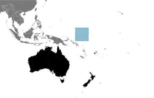
In case Nauru is looking on the map under the Coordinates N/A otherwise in Oceania, in Oceania, an island in the South Pacific Ocean, south of the Marshall Islands.
What is the capital city of Nauru?
The capital city of Nauru: no official capital, Yaren is the de facto capital of Nauru.
What is the time in no official capital?
It is 17 hours ahead of Washington, D.C. during Standard Time; the timezone of no official capital is UTC+12.
What is the Internet code for Nauru?
The Top Level Domain (TLD) for Nauru is: .nr
What is the size of Nauru?
Nauru’s territory is total: 21 sq km; land: 21 sq km, water: 0 sq km.
If we want to describe the size of Nauru’s territory is about 0.1 times the size of Washington, DC.
If we would like to walk around and discover Nauru, we can cover a distance of 0 km.
What is the water coverage of Nauru?
We have already mentioned what percentage of Nauru is covered by water (see below), including a 30 km coastline.
What is the climate like in Nauru?
The climate of Nauru is tropical with a monsoonal pattern: rainy season (November to February).
Geographical data of Nauru
Nauru’s elevation; mean elevation: N/A, elevation extremes; lowest point: Pacific Ocean 0 m, highest point: unnamed elevation along plateau rim 61 m.
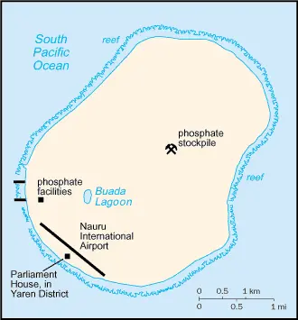
Nauru’s specific geographical details include sandy beach rises to fertile ring around raised coral reefs with phosphate plateau in the center.
Suppose we would like to describe the countries location from a different perspective. In that case, it is safe to say, and easy to read from a map, Nauru is the world’s smallest island country; situated just 53 km south of the Equator; Nauru is one of the three great phosphate rock islands in the Pacific Ocean – the others are Banaba (Ocean Island) in Kiribati and Makatea in French Polynesia.
Resources and land use of Nauru
The country’s main mined products are phosphates, fish. The population partly uses the earlier highlighted land territory and partly left in its natural state: agricultural land: 20%; arable land 0%; permanent crops 20%; permanent pasture 0%; forest: 0%; other: 80% (2011 estimate).
Population data of Nauru
The number of inhabitants of Nauru is 9,591 (July 2016 estimate).
If we examine the proportion of the population distribution, it is safe to say that N/A.
If we look at the proportion of the urbanized and barely populated areas, these are the figures: urban population: 100% of the total population (2015).
Most of the population in Nauru is concentrated in N/A.
Ethnicity in Nauru
According to ethnicity details, the ethnic groups are Nauruan 58%, other Pacific Islander 26%, Chinese 8%, European 8%.
The spoken languages in Nauru are the following: Nauruan 93% (official language, a distinct Pacific Island language), English 2% (widely understood, spoken, and used for most government and commercial purposes), other 5% (includes I-Kiribati 2% and Chinese 2%). Note: percentages represent the main language spoken at home; Nauruan is spoken by 95% of the population, English by 66%, and other languages by 12% (2011 estimate).
What are the most important religions in Nauru?
During the general census, researchers examine the churches, according to this: Protestant 60.4% (includes Nauru Congregational 35.7%, Assembly of God 13%, Nauru Independent Church 9.5%, Baptist 1.5%, and Seventh Day Adventist 0.7%), Roman Catholic 33%, other 3.7%, none 1.8%, unspecified 1.1% (2011 estimate).
Further population data of Nauru
The proportion of gender and age tells a lot about the society as follows 0-14 years: 31.93% (male 1,336 / female 1,726) 15-24 years: 16.09% (male 779 / female 764) 25-54 years: 43.33% (male 2,085 / female 2,071) 55-64 years: 6.29% (male 236 / female 367) 65 years and over: 2.37% (male 89 / female 138) (2016 estimate). It also a significant factor in a society the population growth rate, which in the case of Nauru is 0.52% (2016 estimate).
The population growth rate is based on two elements, the birth and the death rate. In Nauru the birth rate is 24.4 births / 1,000 population (2016 estimate), the death rate 5.9 deaths / 1,000 population (2016 estimate).
In this day and age in developed societies, the first child borns later compared to the previous centuries and decades, so childbearing is extended. In Nauru, the average age of mothers at the first childbirth is N/A.
Although the children’s birth is postponed in the best-case scenario, the parents can still see their kids grow as life expectancy also extended. In the case of Nauru, these figures are. With the introduction of modern medicine, vaccinations, and the proper hygienic conditions, the infant mortality rate is in a steep decline. The infant mortality statistics in Nauru are the following: N/A. Relevant data is the budget of healthcare, which is in this country’s case is 3.3% of GDP (2014).
Economic data of Nauru
Suppose we would like to describe a country. We also have to mention its economy; Revenues of this tiny island – a coral atoll with a land area of 21 square kilometers – traditionally have come from exports of phosphates. Few other resources exist, with most necessities being imported, mainly from Australia. Although revenue sources for the government are limited, the Australian Regional Processing Center’s opening for asylum seekers since 2012 has sparked growth in the economy. Revenue derived from fishing licenses under the “vessel day scheme” has also boo.
GDP is a prominent figure, as all the relevant calculations and statistics are based on it. GDP in Nauru is $150.8 million (2015 estimate).
Another important indicator is the rate of GDP growth, which in Nauru is 8% (2015 estimate), 10% (2014 estimate) 4.5% (2013 estimate).
These statistics affect the world economy; remember, in 2015, the Chinese real GDP growth rate was worse than expected; The world markets fall, and the Chinese stock exchange was temporarily suspended.
A further major factor of a country’s economy, the GDP per capita. In Nauru this is $14,800 (2015 estimate) $13,700 (2014 estimate) $12,500 (2013 estimate).
In the economy, the Trinity is in common places, such as agriculture, industry, and services.
What are the agricultural products Nauru produces?
The main agricultural products of Nauru are coconuts.
Regarding the economy, the essential segments are phosphate mining, offshore banking, coconut products. The crucial and regularly mentioned GDP is based on phosphate mining, offshore banking, coconut products.
Drinking water source in Nauru
It is essential to mention that – thanks to the development of the infrastructure -, the rate of potable water improved: urban: 96.5% of the population, total: 96.5% of the population. Unimproved: urban: 3.5% of the population, total: 3.5% of the population (2015 estimate).
The average number of childbirth in Nauru
In Nauru, the average delivery number is 2.84 children born / woman (2016 estimate).
Population, median age, migration, and citizenship in Nauru
The population’s average age is 26.1 years; male: 26.5 years, female: 25.5 years (2016 estimate). The age of adulthood varies in every country of the world. In Nauru, it is 20 years of age, universal and compulsory.
When we are experiencing an unprecedented scale of migration and globalization, it is an important factor in the number of new immigrants. In Nauru is -13.2 migrant(s) / 1,000 population (2016 estimate). It is important to know how to apply for citizenship: N/A.
Is Nauru a safe destination? Healthcare services and infectious diseases in Nauru
Many of the travelers are looking into the healthcare services and infectious diseases of their destinations. In Nauru, the hospital beds’ density is five beds / 1,000 population (2010).
According to the WHO rating regarding contagious diseases in Nauru: N/A.
However, HIV is not curable but maintainable. Let’s do not forget when the disease surfaced; it was a world threatening condition. Unfortunately, in some countries, it is still very high the number of infected patients and fatalities due to the disease.
In Nauru, the number of HIV/AIDS deaths: N/A.
Regarding tourism obesity, not an important issue, but we have to mention health statistics, as it is the plague of the 20th and the 21st century. The rate of obese adults in Nauru is 45.1% (2014).
What are the natural hazards in Nauru? Is there any?
The most known natural risk in Nauru is periodic droughts.
More interesting facts about Nauru
A few words about the past, as every country and society, is connected to its history; The exact origins of the Nauruans are unclear since their language does not resemble any other in the Pacific region. Germany annexed the island in 1888. A German-British consortium began mining the island’s phosphate deposits early in the 20th century. Australian forces occupied Nauru in World War I; it subsequently became a League of Nations mandate. After the Second World War – and a brutal occupation by Japan – Nauru became a UN trust territory. It achieved independence in 1968 and joined the UN in 1999 as the world’s smallest independent republic.
In every nation’s memory, some cornerstones placed the country on the timeline of history. The date of declaration of independence of Nauru: 31 January 1968 (from Australia-, NZ-, and the UK-administered UN trusteeship).
The flag and other symbols of Nauru
The colors, symbols, and animals on the flag usually have a historical background or an important milestone or memory of the nation.
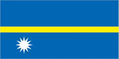
This case is not an exception either; blue with a narrow, horizontal, yellow stripe across the center and a large white 12-pointed star below the stripe on the hoist side; blue stands for the Pacific Ocean, the star indicates the country’s location about the Equator (the yellow stripe) and the 12 points symbolize the 12 original tribes of Nauru.
Apart from the flag, the symbol of national unity is the national anthem. The anthem’s primary purpose is to share the nation’s core values, endeavors, and patriotic feelings.
National symbols of Nauru: frigatebird, Calophyllum flower; national colors: blue, yellow, white.
Constitution of Nauru
The existence of the nation is based on the constitution. Some constitutions knew worldwide, like the U.S. Constitution that was accepted on the 17th of September 1787, in Philadelphia, the United States of America’s Constitution.
It is not related to the declaration of independence that was stolen by Nicolas Cage in the movie National Treasure 🙂
What is the legal system of Nauru?
Most of the time, the legal system of a country is the focus of lawyers. It is a common fact that there are two main approaches in the world, “the law in books” and “the law in action.”
In the Anglo-Saxon world, the practice is the “law in action,” while in the rest of the world, the law is based on Roman law, the “law in books.”
Nauru’s legal system is a mixed legal system of common law based on the English model and customary law.
It was Aristotle who founded the Theory of 3 separations of powers. In his view, these are the council of public affairs, the magistrates, and the justice system. The age of enlightenment was the time when terminologies have defined the way we still use them. In most democratic countries, the three authorities separated from each other. In dictatorships, the rules usually interweaved in one hand.
We can highlight the following structures unicameral parliament (19 seats; members directly elected in multi-seat constituencies by majority vote; members serve 3-year terms) about the legislative branch of Nauru.
About the unemployment rate, labor force, and poverty line in Nauru
One of the major problems of the 21st-century economy is unemployment. Governments are struggling to maintain a low level of the unemployment rate. Still, as a result of automation, the cheap 3rd world labor, and the outsourcing of workflow, these attempts fail. In Nauru, the labor force is N/A. Please bear in mind that the population in Nauru is total: 7.9 deaths / 1,000 live births; male: 10.2 deaths / 1,000 live births, female: 6.1 deaths / 1,000 live births (2016 estimate) – as we already mentioned above.
The rate of unemployment in Nauru is 23% (2011 estimate).
Widely known that the gap between the rich and poor is widening on an enormous scale.
According to the 2017 shocking Oxfam report, the most affluent eight people’s fortune is equal to the wealth of the poorest half of the world’s population.
In Nauru, the households’ income and consumption compared to the entire population: lowest 10%: N/A% highest 10%: N/A%.
Another widely used indicator is the so-called GINI index, which measures the inequalities of statistical dispersion, but is mainly used for measuring the sharing of income and fortune.
The GINI index was named after its founder Corrado Gini, an Italian economist. Gini index has grades between 0-1, but often it is used on a percentage basis. It is 0 if the examined criteria territorial distribution is equal. It is one of the criteria concentrated on the territory. In Nauru, the GINI index is N/A.
The states usually set up a poverty line, which is more or less, is a subjective measure. It varies by country; its base is often the minimum pension, the incomes of the most deficient 20 percent, the X percent of income per capita Etc.
In Nauru, the poverty line people are the lowest 10%: N/A% highest 10%: N/A%.
About the budget and central governments debt of Nauru
The available budget mainly defines the state’s economy. Nauru’s budget is; revenues: $57.8 million, expenditures: $51.8 million (2010 estimate). Taxes and other revenues are N/A.
The budget deficit (Budget surplus (+) or deficit (-)) is N/A.
The fiscal year in Nauru is 1 July – 30 June.
In the country’s economy, we have to consider the public debt. Public debt is the consolidated sum of the state’s local, federal, and central government debt.
Inflation rate and prime lending rate in Nauru
A few further interesting and relevant economic data are the following; Inflation rate: 8% (2015 estimate), 5% (2015 estimate), and the commercial bank prime lending rate: N/A.
Export/import partners and data of Nauru
Nauru, with the export of products, industrial tools, and other services, generates revenue. The export value in Nauru is: $125 million (2013 estimate), $110.3 million (2012 estimate). The total revenue of these activities: phosphates.
The most important export partners of Nauru are N/A.
The most important imported products are food, fuel, manufacturers, building materials, machinery, and the countries from where the import is coming: N/A.
Renewable energies used in Nauru
To suppress the pollution of the environment, renewable energies have to replace the fossil energy. The more the proportion of renewable energies in a country means more effort against pollution. Nauru, the indicator of how much of the country’s produced energy is coming from the hydroelectric source, is 0% of total installed capacity (2012 estimate).
To indicate how much another renewable energy produced is 0% of total installed capacity (2012 estimate).
Telecommunication data of Nauru, calling code
To maintain the economy, the development of a reliable and modern telecommunications infrastructure is crucial. We can say the following about Nauru; adequate local and international radiotelephone communication provided via Australian facilities. International: country code – 674; satellite earth station – 1 Intelsat (Pacific Ocean).
Transport infrastructure in Nauru
In the 21st century, we often say that the world has become small and there are no distances anymore. With widespread air travel when (sometimes) there are no visa restrictions, it is easy to reach other countries, but if the distance is not too long, we can also use railway or water transportation.
The number of airports in Nauru: 1 (2013), and the number of heliports: N/A.
The total length of the roadways in Nauru: total: 30 km, paved: 24 km, unpaved: 6 km (2002).
The total length of the waterways in Nauru: N/A.
Are you traveling to Nauru?
If you plan to travel by plane to Nauru, try our air ticket comparison site, where you can choose from hundreds of carriers and offers. Our application is scanning the market and shows you the best and the cheapest deals without any extra charge or commission.
Are you looking for a hotel, apartment another kind of accommodation in Nauru, Oceania? We are here to help you to find your accommodation from budget to luxury. Our search engine is scanning, regularly updating data from hundreds of accommodation websites and more than a million offers. You can quickly and easily find your hotel stay anywhere in the world, without any extra charge or commission.
Facts & data about Nauru
Name of the country: conventional long way: the Republic of Nauru, traditional short form: Nauru, local long form: the Republic of Nauru, local short state: Nauru, former: Pleasant Island, etymology: the island name may derive from the Nauruan word “anaoero” meaning “I go to the beach.”
| Abbreviation: Nauru | Geographic coordinates: 0 32 S, 166 55 E |
Country Location: Oceania |
| Capital of Nauru: no official capital | GPS of the Capital: N/A |
Position: Oceania, island in the South Pacific Ocean, south of the Marshall Islands |
| Land area: total: 21 sq km; land: 21 sq km, water: 0 sq km | Terrain: sandy beach rises to fertile ring around raised coral reefs with phosphate plateau in center |
Area comparative: about 0.1 times the size of Washington, DC |
| Population: 9,591 (July 2016 estimate) | Population grow rate: 0.52% (2016 estimate) | Sex ratio: at birth: 0.83 male(s) / female, 0-14 years: 0.77 male(s) / female, 15-24 years: 1.02 male(s) / female, 25-54 years: 1.01 male(s) / female, 55-64 years: 0.64 male(s) / female, 65 years and over: 0.63 male(s) / female, total population: 0.89 male(s) / female (2016 estimate) |
| Exports: $125 million (2013 estimate), $110.3 million (2012 estimate) | Imports: $143.1 million (2013 estimate), $41.2 million (2012 estimate) | Import partners: N/A |
| Urbanization: urban population: 100% of the total population (2015) | Major urban area(s): N/A | Median age: total: 26.1 years; male: 26.5 years, female: 25.5 years (2016 estimate) |
| Internet users: total: 5,100. Percent of the population: 53.5% (July 2015 estimate) | Telephones (fixed-lines): total subscriptions: 1,900. Subscriptions per 100 inhabitants: 14 (July 2009 estimate) | Telephones (mobile, cellular): total: 6,800. Subscriptions per 100 inhabitants: 73 (July 2012 estimate) |
| Unemployment rate: 23% (2011 estimate) | Nationality: Nauruan(s) adjective: Nauruan | National holidays: Independence Day, 31 January (1968) |
| Life expectancy at birth: total population: 67.1 years. Male: 63 years, female: 70.5 years (2016 estimate) | Total fertility rate: 2.84 children born / woman (2016 estimate) | Birthrate: 24.4 births / 1,000 population (2016 estimate) |
| Literacy: N/A | Legal system: mixed legal system of common law based on the English model and customary law | Suffrage: 20 years of age, universal and compulsory |
| Industries: phosphate mining, offshore banking, coconut products | Industrial production growth rate: N/A % | GDP real growth rate: 8% (2015 estimate) 10% (2014 estimate) 4.5% (2013 estimate) |
Do you like this Nauru Google Maps & information page?
Please do us a favor: Share or like this page using the icons at the top of the page. We also do encourage you to visit our Facebook page for more travel and country related information.
Thank you for visiting and sharing this map & country information page.