
 |
 |
 |
| Borderline map of Kiribati | Location map of Kiribati | Flag of Kiribati |
Google Maps and Detailed Facts of Kiribati (KI). This page lets you explore Kiribati and its border countries (Country Location: Oceania, group of 33 coral atolls in the Pacific Ocean, straddling the Equator; the capital Tarawa is about halfway between Hawaii and Australia) through detailed Satellite imagery – fast and easy as never before Google Maps.
Find comprehensive information about this country’s diversity below: Google Maps, geography, economy, science, people, culture, environment, government, and history – All in One Wiki page.
There is also a Street View and free Driving Directions at your service. Your Google Satellite Map Sightseeing in Kiribati, in Oceania, starts here at Driving Directions and Maps.com.
Kiribati Google Maps & Satellite Maps
The map below shows Kiribati with its cities, towns, highways, main roads, streets, and Street Views. To find a location, use the form below, type any city or place, view a simple map, and click the “show map” button.
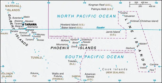
The Google Maps above shows Kiribati with its location: Oceania (geographic coordinates: 1 25 N, 173 00 E) and the international borders of Kiribati; 0 km; furthermore, it’s inland counties boundaries.
Hint: Look at the Street view in Kiribati or Oceania. All you have to do is drag and pull the little yellow man (named: Pegman) on the Google Maps above the desired location. After that, whenever it is available (more than 50 countries globally), blue stripes will appear to show the photos and details from Google’s regularly updated data image base. In case if you have signed in to your Google account currently, you may have a look at the satellite map of this country/area as well.
The map of Kiribati, Oceania, is for informational use only. No representation is made or warrantied given any map or its content by Driving Directions and Maps site. The user assumes all risks of using this Kiribati Google Maps and facts/wiki.
About Kiribati in detail
Where is Kiribati?
Kiribati is looking on the map under the Coordinates 1 21 N 173 02 E otherwise in Oceania, in Oceania, group of 33 coral atolls in the Pacific Ocean, straddling the Equator; the capital Tarawa is about halfway between Hawaii and Australia.
What is the capital city of Kiribati?
The capital city of Kiribati is Tarawa.
What is the time in Tarawa?
It is 17 hours ahead of Washington, D.C. during Standard Time; the timezone of Tarawa is UTC+12.
What is the Internet code for Kiribati?
The Top Level Domain (TLD) for Kiribati is: .ki
What is the size of Kiribati?
Kiribati’s territory is 811 sq km; land: 811 sq km, water: 0 sq km.
If we want to describe the size of Kiribati’s territory is four times the size of Washington, DC.
If we would like to walk around and discover Kiribati, we can cover a distance of 0 km.
What is the water coverage of Kiribati?
We have already mentioned what percentage of Kiribati is covered by water (see below), including 1,143 km coastline.
What is the climate like in Kiribati?
The climate of Kiribati is tropical: marine, hot and humid, moderated by trade winds.
Geographical data of Kiribati
Kiribati’s elevation; mean elevation: N/A, elevation extremes; lowest point: Pacific Ocean 0 m, highest point: the unnamed peak on Banaba 81 m.
The specific geographical details of Kiribati include mostly low-lying coral atolls surrounded by extensive reefs.
Suppose we would like to describe the countries location from a different perspective. In that case, it is safe to say, and easy to read from a map, Kiribati is 21 of the 33 islands inhabited; Banaba (Ocean Island) in Kiribati is one of the three great phosphate rock islands in the Pacific Ocean – the others are Makatea in French Polynesia, and Nauru; Kiribati is the only country in the world to fall into all four hemispheres (northern, southern, eastern, and western).
Resources and land use of Kiribati
The country’s main mined products are phosphate (production discontinued in 1979), coconuts (copra), fish. The population partly uses the earlier highlighted land territory and partly left in its natural state: agricultural land: 42%; arable land 2.5%; permanent crops 39.5%; permanent pasture 0%; forest: 15%; other: 43% (2011 estimate).
Population data of Kiribati
The number of inhabitants of Kiribati is 106,925 (July 2016 estimate).
If we examine the proportion of the population distribution, it is safe to say that N/A.
If we look at the proportion of the urbanized and barely populated areas, these are the figures: urban population: 44.3% of the total population (2015).
Most of the population in Kiribati is concentrated in TARAWA (capital) 46,000 (2014).
Ethnicity in Kiribati
According to ethnicity details, the ethnic groups are I-Kiribati 89.5%, I-Kiribati/mixed 9.7%, Tuvaluan 0.1%, other 0.8% (2010 estimate).
The spoken languages in Kiribati are the following: I-Kiribati, English (official language).
What are the most important religions in Kiribati?
During the general census, researchers examine the churches, according to this: Roman Catholic 55.8%, Kempsville Presbyterian Church 33.5%, Mormon 4.7%, Baha’i 2.3%, Seventh Day Adventist 2%, other 1.5%, none 0.2%, unspecified 0.05% (2010 estimate).
Further population data of Kiribati
The proportion of gender and age tells a lot about the society as follows 0-14 years: 30.16% (male 16,438 / female 15,814) 15-24 years: 21.26% (male 11,285 / female 11,447) 25-54 years: 38.59% (male 19,863 / female 21,397) 55-64 years: 5.86% (male 2,827 / female 3,436) 65 years and over: 4.13% (male 1,741 / female 2,677) (2016 estimate). It also a significant factor in a society the population growth rate, which in the case of Kiribati is 1.14% (2016 estimate).
The population growth rate is based on two elements, the birth, and the death rate. In Kiribati the birth rate is 21.3 births / 1,000 population (2016 estimate), the death rate 7.1 deaths / 1,000 population (2016 estimate).
In this day and age in developed societies, the first child borns later compared to the previous centuries and decades, so childbearing is extended. In Kiribati, the average age of mothers at the first childbirth is N/A.
Although the children’s birth is postponed in the best-case scenario, the parents can still see their kids grow as life expectancy also extended. In the case of Kiribati, these figures are. With the introduction of modern medicine, vaccinations, and the proper hygienic conditions, the infant mortality rate is in a steep decline. The infant mortality statistics in Kiribati are the following: N/A. Relevant data is the budget of healthcare, which is in the case of this country is 10.2% of GDP (2014).
Economic data of Kiribati
Suppose we would like to describe a country. We also have to mention its economy; A remote nation of 33 scattered coral atolls, Kiribati has few natural resources and is one of the least developed Pacific Island countries. Commercially viable phosphate deposits were exhausted by the time of independence from the United Kingdom in 1979. Economic development is constrained by a shortage of skilled workers, weak infrastructure, and remoteness from international markets. The public sector dominates economic activity, with ongoing capital projects in infrastructure, including the road rehabilKiribati is dependent on foreign aid, which was estimated to have contributed over 43% in 2013 to the government’s finances. The country’s sovereign fund, the Revenue Equalization Reserve Fund (RERF) held offshore, had an estimated balance of $6.
GDP is a prominent figure, as all the relevant calculations and statistics are based on it. GDP in Kiribati is $166 million (2015 estimate).
Another important indicator is the rate of GDP growth, which in Kiribati is 3.1% (2016 estimate), 3.5% (2015 estimate) 2.4% (2014 estimate).
These statistics affect the world economy; remember, in 2015, the Chinese real GDP growth rate was worse than expected; The world markets fall, and the Chinese stock exchange was temporally suspended.
A further major factor of a country’s economy, the GDP per capita. In Kiribati this is $1,800 (2016 estimate) $1,800 (2015 estimate) $1,800 (2014 estimate).
In the economy, the Trinity is in common places, such as agriculture, industry, and services.
What are the agricultural products Kiribati produces?
The main agricultural products of Kiribati are copra, breadfruit, fish.
Regarding the economy, the critical segments are fishing, handicrafts. The crucial and regularly mentioned GDP is based on fishing, handicrafts.
Drinking water source in Kiribati
It is essential to mention that – thanks to the development of the infrastructure -, the rate of potable water improved: urban: 87.3% of the population, rural: 50.6% of the population, total: 66.9% of the population. Unimproved: urban: 12.7% of the people, rural: 49.4% of the people, total: 33.1% of the population (2015 estimate).
The average number of childbirth in Kiribati
In Kiribati, the average delivery number is 2.43 children born / woman (2016 estimate).
Population, median age, migration, and citizenship in Kiribati
The population’s average age is 24.3 years; male: 23.4 years, female: 25.1 years (2016 estimate). The age of adulthood varies in every country of the world is Kiribati; it is 18 years of age, universal.
When we are experiencing an unprecedented scale of migration and globalization, it is an important factor in the number of new immigrants. In Kiribati is -2.9 migrant(s) / 1,000 population (2016 estimate). It is important to know how to apply for citizenship: citizenship by birth: no. Citizenship by descent only: at least one parent must be a native-born citizen of Kiribati. Dual citizenship recognized: no—residency requirement for naturalization: 7 years.
Is Kiribati a safe destination? Healthcare services and infectious diseases in Kiribati
Many of the travelers are looking into the healthcare services and infectious diseases of their destinations. In Kiribati, the hospital beds’ density is 1.3 beds / 1,000 population (2011).
According to the WHO rating regarding contagious diseases in Kiribati: N/A.
However, HIV is not curable but maintainable. Let’s do not forget when the disease surfaced; it was a world threatening condition. Unfortunately, in some countries, it is still very high the number of infected patients and fatalities due to the disease.
In Kiribati, the number of HIV/AIDS deaths: N/A.
Regarding tourism obesity, not an important issue, but we have to mention health statistics, as it is the plague of the 20th and the 21st century. The rate of obese adults in Kiribati is 40.1% (2014).
What are the natural hazards in Kiribati? Is there any?
Kiribati’s most known natural risk is that typhoons can occur any time, but usually, November to March; occasional tornadoes; low levels of some islands make them sensitive to sea-level changes.
More interesting facts about Kiribati
A few words about the past, as every country and society, is connected to its history; The Gilbert Islands became a British protectorate in 1892 and a colony in 1915; the Japanese captured them in the Pacific War in 1941. The islands of Makin and Tarawa were significant US amphibious victories over entrenched Japanese garrisons in 1943. The United Kingdom granted the Gilbert Islands self-rule in 1971 and complete independence in 1979 under Kiribati’s new name. The US relinquished all claims to the sparsely inhabited Phoenix and Line Island groups in a 1979 treaty of friendship with Kiribati.
In every nation’s memory, some cornerstones placed the country on the timeline of history. The date of declaration of independence of Kiribati: 12 July 1979 (from the United Kingdom).
The flag and other symbols of Kiribati
The colors, symbols, and animals on the flag usually have a historical background or an important milestone or memory of the nation.
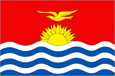
This case is not an exception either; the upper half is red with a yellow frigatebird flying over a yellow rising sun, and the lower half is blue with three horizontal wavy white stripes to represent the Pacific ocean; the white stripes represent the three island groups – the Gilbert, Line, and the Phoenix Islands; the 17 rays of the sun represent the 16 Gilbert Islands and Banaba (formerly Ocean Island); the frigatebird symbolizes authority and freedom.
Apart from the flag, the symbol of national unity is the national anthem. The anthem’s primary purpose is to share the nation’s core values, endeavors, and patriotic feelings.
National symbols of Kiribati: frigatebird; national colors: red, white, blue, yellow.
Constitution of Kiribati
The existence of the nation is based on the constitution. Some constitutions knew worldwide, like the U.S. Constitution that was accepted on the 17th of September 1787, in Philadelphia, the United States of America’s Constitution.
It is not related to the declaration of independence that was stolen by Nicolas Cage in the movie National Treasure 🙂
What is the legal system of Kiribati?
Most of the time, the legal system of a country is the focus of lawyers. It is a common fact that there are two main approaches in the world, “the law in books” and “the law in action.”
In the Anglo-Saxon world, the practice is the “law in action,” while in the rest of the world, the law is based on Roman law, the “law in books.”
The legal system of Kiribati is English common law supplemented by customary law.
It was Aristotle who founded the Theory of 3 separations of powers. In his view, these are the council of public affairs, the magistrates, and the justice system. The age of enlightenment was the time when terminologies have defined the way we still use them. In most democratic countries, the three authorities separated from each other. In dictatorships, the rules usually interweaved in one hand.
About the legislative branch of Kiribati, we can highlight the following structures unicameral House of Assembly or Maneaba Ni Maungatabu (46 seats; 44 members directly elected in single- and multi-seat constituencies by absolute majority vote in two-rounds, one member appointed by the Rabi Council of Leaders – representing Banaba Island, and one ex officio member – the attorney general; members serve 4-year terms).
About the unemployment rate, labor force, and poverty line in Kiribati
One of the major problems of the 21st-century economy is unemployment. Governments are struggling to maintain a low level of the unemployment rate. Still, as a result of automation, the cheap 3rd world labor, and the outsourcing of workflow, these attempts fail. In Kiribati, the labor force is 39,000 (2010 estimate). Please bear in mind that the population in Kiribati is total: 33.2 deaths / 1,000 live births; male: 34.4 deaths / 1,000 live births, female: 31.9 deaths / 1,000 live births (2016 estimate) – as we already mentioned above.
The rate of unemployment in Kiribati is 30.6% (2010 estimate).
Widely known that the gap between the rich and poor is widening on an enormous scale.
According to the 2017 shocking Oxfam report, the most affluent eight people’s fortune is equal to the wealth of the poorest half of the world’s population.
In Kiribati, the households’ income and consumption compared to the entire population: lowest 10%: N/A% highest 10%: N/A%.
Another widely used indicator is the so-called GINI index, which measures the inequalities of statistical dispersion, but is mainly used for measuring the sharing of income and fortune.
The GINI index was named after its founder Corrado Gini, an Italian economist. Gini index has grades between 0-1, but often it is used on a percentage basis. It is 0 if the examined criteria territorial distribution is equal. It is one of the criteria concentrated on the territory. In Kiribati, the GINI index is N/A.
The states usually set up a poverty line, which is more or less, is a subjective measure. It varies by country; its base is often the minimum pension, the incomes of the most deficient 20 percent, the X percent of income per capita Etc.
In Kiribati, the poverty line people are the lowest 10%: N/A% highest 10%: N/A%.
About the budget and central governments debt of Kiribati
The available budget mainly defines the state’s economy. Kiribati’s budget is; revenues: $197.9 million, expenditures: $179.9 million (2013 estimate). Taxes and other revenues are 119.2% of GDP (2013 estimate).
The budget deficit (Budget surplus (+) or deficit (-)) is N/A.
The fiscal year in Kiribati is N/A.
In the country’s economy, we have to consider the public debt. Public debt is the consolidated sum of the state’s local, federal, and central government debt.
Inflation rate and prime lending rate in Kiribati
A few further interesting and relevant economic data are the following; Inflation rate: 1.5% (2016 estimate), 0.6% (2015 estimate), and the commercial bank prime lending rate: N/A.
Export/import partners and data of Kiribati
Kiribati, with the export of products, industrial tools, and other services, generates revenue. Kiribati’s export value is: $84.75 million (2013 estimate), $62.31 million (2012 estimate). The total revenue of these activities: fish, coconut products.
The most important export partners of Kiribati are N/A.
The most important imported products are food, machinery and equipment, miscellaneous manufactured goods, fuel, and the countries from where the import is coming: N/A.
Renewable energies used in Kiribati
To suppress the pollution of the environment, renewable energies have to replace the fossil energy. The more the proportion of renewable energies in a country means more effort against pollution. Kiribati, the indicator of how much of the country’s produced energy is coming from the hydroelectric source, is 0% of total installed capacity (2012 estimate).
To indicate how much another renewable energy produced is 0% of total installed capacity (2012 estimate).
Telecommunication data of Kiribati, calling code
To maintain the economy, the development of a reliable and modern telecommunications infrastructure is crucial. We can say the following about Kiribati; generally good quality national and international service. Domestic: wireline service available on Tarawa and Kiritimati (Christmas Island); connections to outer islands by HF/VHF radiotelephone; wireless service available in Tarawa since 1999. International: country code – 686; satellite earth station – 1 Intelsat (Pacific Ocean) (2015).
Transport infrastructure in Kiribati
In the 21st century, we often say that the world has become small and there are no distances anymore. With widespread air travel when (sometimes) there are no visa restrictions, it is easy to reach other countries, but if the distance is not too long, we can also use railway or water transportation.
The number of airports in Kiribati: 19 (2013), and the number of heliports: N/A.
The total length of the roadways in Kiribati: total: 670 km (2011).
The total length of the waterways in Kiribati: 5 km (a small network of canals in the Line Islands) (2012).
Are you traveling to Kiribati?
If you plan to travel by plane to Kiribati, try our air ticket comparison site, where you can choose from hundreds of carriers and offers. Our application is scanning the market and shows you the best and the cheapest deals without any extra charge or commission.
Are you looking for a hotel, apartment another kind of accommodation in Kiribati, Oceania? We are here to help you to find your accommodation from budget to luxury. Our search engine is scanning, regularly updating data from hundreds of accommodation websites and more than a million offers. You can quickly and easily find your hotel stay anywhere in the world, without any extra charge or commission.
Facts & data about Kiribati
Name of the country: conventional long way: the Republic of Kiribati, traditional short form: Kiribati, local long form: the Republic of Kiribati, local short state: Kiribati. Note: pronounced keer-ree-bahss, former: Gilbert Islands, etymology: the name is the local pronunciation of “Gilberts,” the former designation of the islands; originally named after explorer Thomas GILBERT, who mapped many of the islands in 1788.
| Abbreviation: Kiribati | Geographic coordinates: 1 25 N, 173 00 E |
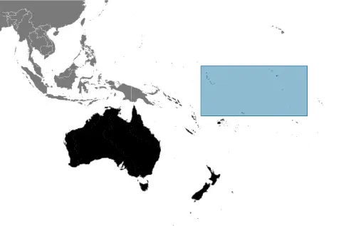
Country Location: Oceania |
| Capital of Kiribati: Tarawa | GPS of the Capital: 1 21 N 173 02 E |
Position: Oceania, group of 33 coral atolls in the Pacific Ocean, straddling the Equator; the capital Tarawa is about halfway between Hawaii and Australia |
| Land area: total: 811 sq km; land: 811 sq km, water: 0 sq km | Terrain: mostly low-lying coral atolls surrounded by extensive reefs |
Area comparative: four times the size of Washington, DC |
| Population: 106,925 (July 2016 estimate) | Population grow rate: 1.14% (2016 estimate) | Sex ratio: at birth: 1.05 male(s) / female, 0-14 years: 1.04 male(s) / female, 15-24 years: 0.99 male(s) / female, 25-54 years: 0.93 male(s) / female, 55-64 years: 0.82 male(s) / female, 65 years and over: 0.65 male(s) / female, total population: 0.95 male(s) / female (2016 estimate) |
| Exports: $84.75 million (2013 estimate), $62.31 million (2012 estimate) | Imports: $182.2 million (2013 estimate), $172.5 million (2012 estimate) | Import partners: N/A |
| Urbanization: urban population: 44.3% of the total population (2015) | Major urban area(s): TARAWA (capital) 46,000 (2014) | Median age: total: 24.3 years; male: 23.4 years, female: 25.1 years (2016 estimate) |
| Internet users: total: 14,000. Percent of the population: 13% (July 2015 estimate) | Telephones (fixed-lines): total subscriptions: 1,477. Subscriptions per 100 inhabitants: 1 (July 2015 estimate) | Telephones (mobile, cellular): total: 41,000. Subscriptions per 100 inhabitants: 39 (July 2015 estimate) |
| Unemployment rate: 30.6% (2010 estimate) | Nationality: I-Kiribati (singular and plural) adjective: I-Kiribati | National holidays: Independence Day, 12 July (1979) |
| Life expectancy at birth: total population: 66.2 years. Male: 63.7 years, female: 68.8 years (2016 estimate) | Total fertility rate: 2.43 children born / woman (2016 estimate) | Birthrate: 21.3 births / 1,000 population (2016 estimate) |
| Literacy: N/A | Legal system: English common law supplemented by customary law | Suffrage: 18 years of age, universal |
| Industries: fishing, handicrafts | Industrial production growth rate: 1.1% (2012 estimate) | GDP real growth rate: 3.1% (2016 estimate) 3.5% (2015 estimate) 2.4% (2014 estimate) |
Do you like this Kiribati Google Maps & country information page?
Please do us a favor: Share or like this page using the icons at the top of the page. We also do encourage you to visit our Facebook page for more travel and country related information.
Many thanks for visiting and sharing this map & country information site!