
 |
 |
 |
| Borderline map of Marshall Islands | Location map of Marshall Islands | Flag of Marshall Islands |
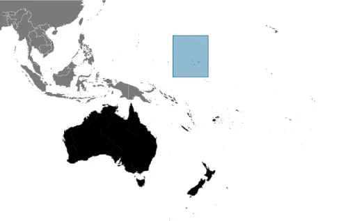
Google Maps and Detailed Facts of the Marshall Islands (HM). This page lets you explore the Marshall Islands and its border countries (Country Location: Oceania, two archipelagic island chains of 29 atolls, each made up of many small islets, and five single islands in the North Pacific Ocean, about halfway between Hawaii and Australia) through detailed Satellite imagery – fast and easy as never before Google Maps.
Find comprehensive information about this country’s diversity below: Google Maps, geography, economy, science, people, culture, environment, government, and history – All in One Wiki page.
There is also a Street View and free Driving Directions at your service. In Oceania, your Google Satellite Map Sightseeing in the Marshall Islands starts here at Driving Directions and Maps.com.
Marshall Islands Google Maps & Satellite Maps
The map below shows the Marshall Islands with its cities, towns, highways, main roads, streets, and Street Views. To find a location, use the form below, type any city or place, view a simple map, and click the “show map” button.
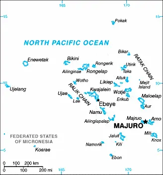
The Google Maps above shows the Marshall Islands with its location: Oceania (geographic coordinates: 9 00 N, 168 00 E) and the international borders of Marshall Islands; 0 km; furthermore, it’s inland counties boundaries.
Hint: Look at the Street view in the Marshall Islands or Oceania. All you have to do is drag and pull the little yellow man (named: Pegman) on the Google Maps above the desired location. After that, whenever it is available (more than 50 countries globally), blue stripes will appear to show the photos and details from Google’s regularly updated data image base. In case if you have signed in to your Google account currently, you may have a look at the satellite map of this country/area as well.
The map of the Marshall Islands, Oceania, is for informational use only. No representation is made or warrantied given any map or its content by Driving Directions and Maps site. The user assumes all risks of using this Marshall Islands Google Maps and facts/wiki.
About the Marshall Islands in detail
Where is the Marshall Islands?
The Marshall Islands, in case, if you are looking on the map under the Coordinates 7 06 N 171 23 E otherwise in Oceania, in Oceania, two archipelagic island chains of 29 atolls, each made up of many small islets, and five single islands in the North Pacific Ocean, about halfway between Hawaii and Australia.
What is the capital city of the Marshall Islands?
The capital city of the Marshall Islands is Majuro.
What is the time in Majuro?
It is 17 hours ahead of Washington, D.C. during Standard Time; Majuro’s timezone is UTC+12.
What is the Internet code for the Marshall Islands?
The Top Level Domain (TLD) for the Marshall Islands is: .mh
What is the size of the Marshall Islands?
The territory of Marshall Islands is total: 181 sq km; land: 181 sq km, water: 0 sq km.
If we want to describe the size of the Marshall Islands’ territory is about the size of Washington, DC.
If we would like to walk around and discover the Marshall Islands, we can cover 0 km.
What is the water coverage of the Marshall Islands?
We have already mentioned what percentage of Marshall Islands is covered by water (see below), and this includes 370.4 km coastline.
What is the climate like in the Marshall Islands?
The Marshall Islands climate is tropical: hot and humid: wet season May to November: islands border typhoon belt.
Geographical data of Marshall Islands
The elevation of Marshall Islands; mean height: N/A, elevation extremes; lowest point: Pacific Ocean 0 m, highest point: unnamed location on Likiep 10 m.
The specific geographical details of the Marshall Islands include low coral limestone and sand islands.
Suppose we would like to describe the countries location from a different perspective. In that case, it is safe to say, and easy to read from a map, Marshall Islands is the islands of Bikini and Enewetak are former US nuclear test sites; Kwajalein atoll, famous as a World War II battleground, surrounds the world’s largest lagoon and is used as a US missile test range; the island city of Ebeye is the second-largest settlement in the Marshall Islands, after the capital of Majuro, and one of the most densely populated locations in the Pacific.
Resources and land use of the Marshall Islands
The country’s main mined products are coconut products, marine products, deep seabed minerals. The population partly uses the earlier highlighted land territory and partly left in its natural state: agricultural land: 50.7%; arable land 7.8%; permanent crops 31.2%; permanent pasture 11.7%; forest: 49.3%; other: 0% (2011 estimate).
Population data of Marshall Islands
The number of inhabitants of the Marshall Islands is 73,376 (July 2016 estimate).
If we examine the proportion of the population distribution, it is safe to say that N/A.
If we look at the proportion of the urbanized and barely populated areas, these are the figures: urban population: 72.7% of the total population (2015).
Most of the Marshall Islands population is concentrated in MAJURO (capital) 31,000 (2014).
Ethnicity in the Marshall Islands
According to ethnicity details, the ethnic groups are Marshallese 92.1%, mixed Marshallese 5.9%, other 2% (2006).
Spoken languages in the Marshall Islands
The spoken languages in the Marshall Islands are the following: Marshallese (official language) 98.2%, other languages 1.8% (1999 census). Note English (official language), widely spoken as a second language.
What are the most important religions in the Marshall Islands?
During the general census, researchers examine the churches, according to this: Protestant 54.8%, Assembly of God 25.8%, Roman Catholic 8.4%, Bukot nan Jesus 2.8%, Mormon 2.1%, other Christian 3.6%, additional 1%, none 1.5% (1999 census).
Further population data of Marshall Islands
The proportion of gender and age tells a lot about the society as follows 0-14 years: 35.48% (male 13,273 / female 12,758) 15-24 years: 17.54% (male 6,545 / female 6,326) 25-54 years: 37.4% (male 13,966 / female 13,475) 55-64 years: 5.79% (male 2,160 / female 2,086) 65 years and over: 3.8% (male 1,370 / female 1,417) (2016 estimate). It also a significant factor in a society the population growth rate, which in the case of Marshall Islands is 1.6% (2016 estimate).
The population growth rate is based on two elements, the birth and the death rate. In Marshall Islands the birth rate is 25 births / 1,000 population (2016 estimate), the death rate 4.2 deaths / 1,000 population (2016 estimate).
In this day and age in developed societies, the first child borns later compared to the previous centuries and decades, so childbearing is extended. In the Marshall Islands, the average age of mothers at the first childbirth is N/A.
Although the children’s birth is postponed in the best-case scenario, the parents can still see their kids grow as life expectancy also extended. In the case of the Marshall Islands, these figures are. With the introduction of modern medicine, vaccinations, and the proper hygienic conditions, the infant mortality rate is in a steep decline. The infant mortality statistics in the Marshall Islands are the following: N/A. Relevant data is the budget of healthcare, which is in the case of this country is 17.1% of GDP (2014).
Economic data of Marshall Islands
Suppose we would like to describe a country, we also have to mention its economy; US assistance and lease payments for the use of Kwajalein Atoll as a US military base are the mainstays of this small island country. Agricultural production, primarily subsistence, is concentrated on small farms; the most important commercial crops are coThe Marshall Islands received roughly $1 billion in aid from the US during 1986-2001 under the original Compact of Free Association (Compact). In 2002 and 2003, the US and the Marshall Islands renegotiated the Compact’s financial package for a 20-year per.
GDP is a prominent figure, as all the relevant calculations and statistics are based on it. GDP in the Marshall Islands is $188 million (2015 estimate).
Another important indicator is the rate of GDP growth, which in the Marshall Islands is 1.7% (2016 estimate), 1.4% (2015 estimate) 0.4% (2014 estimate).
These statistics affect the world economy; remember, in 2015, the Chinese real GDP growth rate was worse than expected; The world markets fall, and the Chinese stock exchange was temporarily suspended.
A further major factor of a country’s economy, the GDP per capita. In Marshall Islands this is $3,300 (2016 estimate) $3,200 (2015 estimate) $3,200 (2014 estimate).
In the economy, the Trinity is in common places, such as agriculture, industry, and services.
What are the agricultural products the Marshall Islands produces?
The main agricultural products of the Marshall Islands are coconuts, tomatoes, melons, taro, breadfruit, fruits, pigs, chickens.
The important segments are copra, tuna processing, tourism, and craft items (from seashells, wood, and pearls). The crucial and regularly mentioned GDP is based on copra, tuna processing, tourism, craft items (from seashells, wood, and pearls).
Drinking water source in the Marshall Islands
It is essential to mention that – thanks to the development of the infrastructure -, the rate of potable water improved: urban: 93.5% of the population, rural: 97.6% of the population, total: 94.6% of the population. Unimproved: urban: 6.5% of the people, rural: 2.4% of the population, total: 5.4% of the population (2015 estimate).
The average number of childbirth in the Marshall Islands
The average delivery number is 3.09 children born / woman (2016 estimate).
Population, median age, migration, and citizenship in the Marshall Islands
The population’s average age is 22.7 years; male: 22.6 years, female: 22.8 years (2016 estimate). The age of adulthood varies in every country of the world in the Marshall Islands; it is 18 years of age, universal.
When we are experiencing an unprecedented scale of migration and globalization, it is an important factor in the number of new immigrants. In Marshall Islands is -4.8 migrant(s) / 1,000 population (2016 estimate). It is important to know how to apply for citizenship: citizenship by birth: no. Citizenship by descent only: at least one parent must be a citizen of the Marshall Islands. Dual citizenship recognized: no—the residency requirement for naturalization: 5 years.
Is the Marshall Islands a safe destination? Healthcare services and infectious diseases in the Marshall Islands
Many of the travelers are looking into the healthcare services and infectious diseases of their destinations. In the Marshall Islands, the hospital beds’ density is 2.7 beds / 1,000 population (2010).
According to the WHO rating regarding contagious diseases in the Marshall Islands the note: active local transmission of Zika virus by Aedes species mosquitoes has been identified in this country (as of August 2016); it poses an important risk (a large number of cases possible) among US citizens if bitten by an infective mosquito; other less common ways to get Zika are through sex, via blood transfusion, or during pregnancy, in which the pregnant woman passes Zika virus to her fetus (2016).
However, HIV is not curable but maintainable. Let’s do not forget when the disease surfaced; it was a world threatening condition. Unfortunately, in some countries, it is still very high the number of infected patients and fatalities due to the disease.
In the Marshall Islands, the number of HIV/AIDS deaths: N/A.
Regarding tourism obesity, not an important issue, but we have to mention health statistics, as it is the plague of the 20th and the 21st century. The rate of obese adults in the Marshall Islands is 42.3% (2014).
What are the natural hazards in the Marshall Islands? Is there any?
The most known natural risk in the Marshall Islands is infrequent typhoons.
More interesting facts about the Marshall Islands
A few words about the past, as every country and society, is connected to its history; After almost four decades under US administration as the easternmost part of the UN Trust Territory of the Pacific Islands, the Marshall Islands attained independence in 1986 a Compact of Free Association. Compensation claims continue due to US nuclear testing on some of the atolls between 1947 and 1962. The Marshall Islands hosts the US Army Kwajalein Atoll Reagan Missile Test Site, a critical installation in the US missile defense network. Kwajalein also hosts one of four dedicated ground antennas (the others are on Ascension (Saint Helena, Ascension, and Tristan da Cunha), Diego Garcia (British Indian Ocean Territory), and at Cape Canaveral, Florida (US)) that assist in the operation of the Global Positioning System (GPS) navigation system.
In every nation’s memory, some cornerstones placed the country on the timeline of history. The date of declaration of independence of Marshall Islands: 21 October 1986 (from the US-administered UN trusteeship).
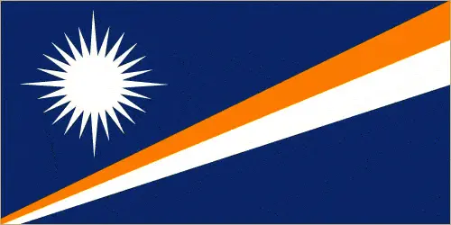
The flag and other symbols of the Marshall Islands
The colors, symbols, and animals on the flag usually have a historical background or an important milestone or memory of the nation.
This case is not an exception either; blue with two stripes radiating from the lower hoist-side corner – orange (top) and white; a white star with four large rays and 20 small rays appears on the hoist side above the two stripes; blue represents the Pacific Ocean, the orange stripe signifies the Ralik Chain or sunset and courage, while the white stripe signifies the Ratak Chain or sunrise and peace; the star symbolizes the cross of Christianity, each of the 24 rays designates one of the electoral districts in the country, and the four more enormous rays highlight the principal cultural centers of Majuro, Jaluit, Wotje, and Ebeye; the rising diagonal band can also be interpreted as representing the equator, with the star showing the archipelago’s position just to the north.
Apart from the flag, the symbol of national unity is the national anthem. The anthem’s primary purpose is to share the nation’s core values, endeavors, and patriotic feelings.
National symbols of Marshall Islands: a 24-rayed star; national colors: blue, white, orange.
Constitution of Marshall Islands
The existence of the nation is based on the constitution. Some constitutions knew worldwide, like the U.S. Constitution that was accepted on the 17th of September 1787, in Philadelphia, the United States of America’s Constitution.
It is not related to the declaration of independence that was stolen by Nicolas Cage in the movie National Treasure 🙂
What is the legal system of the Marshall Islands?
Most of the time, the legal system of a country is the focus of lawyers. It is a common fact that there are two main approaches in the world, “the law in books” and “the law in action.”
In the Anglo-Saxon world, the practice is the “law in action,” while in the rest of the world, the law is based on Roman law, the “law in books.”
The legal system of the Marshall Islands is a mixed legal system of US and English common law, customary law, and local statutes.
It was Aristotle who founded the Theory of 3 separations of powers. In his view, these are the council of public affairs, the magistrates, and the justice system. The age of enlightenment was the time when terminologies have defined the way we still use them. In most democratic countries, the three authorities separated from each other. In dictatorships, the rules usually interweaved in one hand.
About the legislative branch of Marshall Islands, we can highlight the following structures bicameral legislature consists of the Council of Iroij (12 seats; consists of tribal chiefs chosen by holders of the chieftainship among the constituent islands) and the National Parliament or Nitijela (33 seats; members directly elected by a simple majority vote to serve 4-year terms).
About the unemployment rate, labor force, and poverty line in the Marshall Islands
One of the major problems of the 21st-century economy is unemployment. Governments are struggling to maintain a low level of the unemployment rate. Still, as a result of automation, the cheap 3rd world labor, and the outsourcing of workflow, these attempts fail. In the Marshall Islands, the labor force is 10,670 (2013 estimate). Please bear in mind that the population in Marshall Islands is total: 20 deaths / 1,000 live births; male: 22.5 deaths / 1,000 live births, female: 17.3 deaths / 1,000 live births (2016 estimate) – as we already mentioned above.
The rate of unemployment in the Marshall Islands is 36% (2006 estimate).
Widely known that the gap between the rich and poor is widening on an enormous scale.
According to the 2017 shocking Oxfam report, the most affluent eight people’s fortune is equal to the wealth of the poorest half of the world’s population.
In the Marshall Islands, the households’ income and consumption compared to the entire population: lowest 10%: N/A% highest 10%: N/A%.
Another widely used indicator is the so-called GINI index, which measures the inequalities of statistical dispersion, but is mainly used for measuring the sharing of income and fortune.
The GINI index was named after its founder Corrado Gini, an Italian economist. Gini index has grades between 0-1, but often it is used on a percentage basis. It is 0 if the examined criteria territorial distribution is equal. It is one of the criteria concentrated on the territory. In the Marshall Islands, the GINI index is N/A.
The states usually set up a poverty line, which is more or less, is a subjective measure. It varies by country; its base is often the minimum pension, the incomes of the most deficient 20 percent, the X percent of income per capita Etc.
In the Marshall Islands, the poverty line people are the lowest 10%: N/A% highest 10%: N/A%.
About the budget and central governments debt of the Marshall Islands
The available budget mainly defines the state’s economy. The Marshall Islands budget is; revenues: $116.7 million, expenditures: $113.9 million (2013 estimate). Taxes and other revenues are 62.1% of GDP (2013 estimate).
The budget deficit (Budget surplus (+) or deficit (-)) is N/A.
The fiscal year in the Marshall Islands is 1 October – 30 September.
In the country’s economy, we have to consider the public debt. Public debt is the consolidated sum of the state’s local, federal, and central government debt.
Inflation rate and prime lending rate in the Marshall Islands
A few further interesting and relevant economic data are the following; Inflation rate: 0.7% (2016 estimate), -2.2% (2015 estimate), and the commercial bank prime lending rate: N/A.
Export/import partners and data of the Marshall Islands
The Marshall Islands, with the export of products, industrial tools, and other services, generates revenue. The export value in the Marshall Islands is $53.7 million (2013 estimate), $58.1 million (2012). The total revenue of these activities: copra cake, coconut oil, handicrafts, fish.
The most important export partners of the Marshall Islands are N/A.
The most important imported products are foodstuffs, machinery and equipment, fuels, beverages, tobacco, and the countries from where the import is coming: N/A.
Renewable energies used in the Marshall Islands
To suppress the pollution of the environment, renewable energies have to replace the fossil energy. The more the proportion of renewable energies in a country means more effort against pollution. The Marshall Islands, the indicator of how much of the country’s produced energy is coming from the hydroelectric source, is N/A.
To indicate how much another renewable energy produced is N/A.
Telecommunication data of Marshall Islands, calling code
To maintain the economy, the development of a reliable and modern telecommunications infrastructure is crucial. We can say the following about the Marshall Islands; digital switching equipment; current services include telex, cellular, Internet, international calling, caller ID, and leased data circuits. Domestic: Majuro Atoll and Ebeye and Kwajalein islands have regular, seven-digit, direct-dial telephones; other islands interconnected by high-frequency radiotelephone (used mostly for government purposes) and mini-satellite telephones. International: country code – 692; satellite earth stations – 2 Intelsat (Pacific Ocean); US Government satellite communications system on Kwajalein (2005).
Transport infrastructure in the Marshall Islands
In the 21st century, we often say that the world has become small and there are no distances anymore. With widespread air travel when (sometimes) there are no visa restrictions, it is easy to reach other countries, but if the distance is not too long, we can also use railway or water transportation.
The number of airports in the Marshall Islands: 15 (2013), and the number of heliports: N/A.
The total length of the roadways in the Marshall Islands: total: 2,028 km, paved: 75 km, note: roads are mostly unimproved (2007).
The total length of the waterways in the Marshall Islands: N/A.
Are you traveling to the Marshall Islands?
If you plan to travel by plane to the Marshall Islands, try our air ticket comparison site, where you can choose from hundreds of carriers and offers. Our application is scanning the market and shows you the best and the cheapest deals without any extra charge or commission.
Are you looking for a hotel, apartment another kind of accommodation in the Marshall Islands, Oceania? We are here to help you to find your accommodation from budget to luxury. Our search engine is scanning, regularly updating data from hundreds of accommodation websites and more than a million offers. You can quickly and easily find your hotel stay anywhere in the world, without any extra charge or commission.
Facts & data about the Marshall Islands
Name of the country: conventional long way: the Republic of the Marshall Islands, traditional short form: Marshall Islands, local long form: the Republic of the Marshall Islands, local short state: Marshall Islandsabbreviation: RMI, former: Trust Territory of the Pacific Islands, Marshall Islands District, etymology: named after British Captain John MARSHALL, who charted many of the islands in 1788.
| Abbreviation: Marshall Islands | Geographic coordinates: 9 00 N, 168 00 E |
Country Location: Oceania |
| Capital of Marshall Islands: Majuro | GPS of the Capital: 7 06 N 171 23 E |
Position: Oceania, two archipelagic island chains of 29 atolls, each made up of many small islets, and five single islands in the North Pacific Ocean, about halfway between Hawaii and Australia |
| Land area: total: 181 sq km; land: 181 sq km, water: 0 sq km | Terrain: low coral limestone and sand islands |
Area comparative: about the size of Washington, DC |
| Population: 73,376 (July 2016 estimate) | Population grow rate: 1.6% (2016 estimate) | Sex ratio: at birth: 1.05 male(s) / female, 0-14 years: 1.04 male(s) / female, 15-24 years: 1.03 male(s) / female, 25-54 years: 1.04 male(s) / female, 55-64 years: 1.04 male(s) / female, 65 years and over: 0.97 male(s) / female, total population: 1.04 male(s) / female (2016 estimate) |
| Exports: $53.7 million (2013 estimate), $58.1 million (2012) | Imports: $133.7 million (2013 estimate), $120.9 million (2012) | Import partners: N/A |
| Urbanization: urban population: 72.7% of the total population (2015) | Major urban area(s): MAJURO (capital) 31,000 (2014) | Median age: total: 22.7 years; male: 22.6 years, female: 22.8 years (2016 estimate) |
| Internet users: total: 14,000. Percent of the population: 19.3% (July 2015 estimate) | Telephones (fixed-lines): total subscriptions: 2,361. Subscriptions per 100 inhabitants: 3 (July 2014 estimate) | Telephones (mobile, cellular): total: 16,000. Subscriptions per 100 inhabitants: 21 (July 2015 estimate) |
| Unemployment rate: 36% (2006 estimate) | Nationality: Marshallese (singular and plural) adjective: Marshallese | National holidays: Constitution Day, 1 May (1979) |
| Life expectancy at birth: total population: 73.1 years. Male: 70.9 years, female: 75.4 years (2016 estimate) | Total fertility rate: 3.09 children born / woman (2016 estimate) | Birthrate: 25 births / 1,000 population (2016 estimate) |
| Literacy: N/A | Legal system: mixed legal system of US and English common law, customary law, and local statutes | Suffrage: 18 years of age, universal |
| Industries: copra, tuna processing, tourism, craft items (from seashells, wood, and pearls) | Industrial production growth rate: N/A % | GDP real growth rate: 1.7% (2016 estimate) 1.4% (2015 estimate) 0.4% (2014 estimate) |
Do you like this Marshall Islands Google Maps & country information page?
Please do us a favor: Share or like this page using the icons at the top of the page. We also do encourage you to visit our Facebook page for more travel and country related information.
Many thanks for visiting and sharing this map & country information site!