
 |
 |
 |
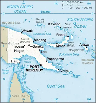
| Borderline map of Papua New Guinea | Location map of Papua New Guinea | Flag of Papua New Guinea |
Google Maps and Detailed Facts of Papua New Guinea (PG). This page lets you explore Papua New Guinea and its border countries (Country Location: Oceania, group of islands including the eastern half of the island of New Guinea between the Coral Sea and the South Pacific Ocean, east of Indonesia) through detailed Satellite imagery – fast and easy as never before Google Maps.
Find comprehensive information about this country’s diversity below: Google Maps, geography, economy, science, people, culture, environment, government, and history – All in One Wiki page.
There is also a Street View and free Driving Directions at your service. In Oceania, your Google Satellite Map Sightseeing in Papua New Guinea starts here at Driving Directions and Maps.com.
Papua New Guinea Google Maps & Satellite Maps
The map below shows Papua New Guinea with its cities, towns, highways, main roads, streets, and Street Views. To find a location, use the form below, type any city or place, view a simple map, and click the “show map” button.
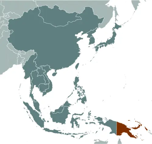
The Google Maps above shows Papua New Guinea with its location: Oceania (geographic coordinates: 6 00 S, 147 00 E) and the international borders of Papua New Guinea; total: 824 km. Border countries (total: 1): Indonesia 824 km; furthermore, it’s inland counties boundaries.
Hint: Look at the Street view in Papua New Guinea or Oceania. All you have to do is drag and pull the little yellow man (named: Pegman) on the Google Maps above the desired location. After that, whenever it is available (more than 50 countries globally), blue stripes will appear to show the photos and details from Google’s regularly updated data image base. In case if you have signed in to your Google account currently, you may have a look at the satellite map of this country/area as well.
The map of Papua New Guinea, Oceania, is for informational use only. No representation is made or warrantied given any map or its content by Driving Directions and Maps site. The user assumes all risks of using this Papua New Guinea Google Maps and facts/wiki.
About Papua New Guinea in detail
Where is Papua New Guinea?
Papua New Guinea, in case, if you are looking on the map under the Coordinates 9 27 S 147 11 E otherwise in Oceania, in Oceania, group of islands including the eastern half of the island of New Guinea between the Coral Sea and the South Pacific Ocean, east of Indonesia.
What is the capital city of Papua New Guinea?
The capital city of Papua New Guinea is Port Moresby.
What is the time in Port Moresby?
It is 15 hours ahead of Washington, D.C. during Standard Time; the timezone of Port Moresby is UTC+10.
What is the Internet code for Papua New Guinea?
The Top Level Domain (TLD) for Papua New Guinea is: .pg
What is the size of Papua New Guinea?
Papua New Guinea territory is total: 462,840 sq km; land: 452,860 sq km, water: 9,980 sq km.
If we want to describe the size of the territory of Papua New Guinea is slightly larger than California.
If we would like to walk around and discover Papua New Guinea, we can cover a total distance: 824 km.
What is the water coverage of Papua New Guinea?
We have already mentioned what percentage of Papua New Guinea is covered by water (see below), and this includes a 5,152 km coastline.
What is the climate like in Papua New Guinea?
The climate of Papua New Guinea is tropical: northwest monsoon (December to March), southeast monsoon (May to October): slight seasonal temperature variation.
Geographical data of Papua New Guinea
Papua New Guinea; mean elevation: 667 m, elevation extremes; lowest point: Pacific Ocean 0 m, highest point: Mount Wilhelm 4,509 m.
The specific geographical details of Papua New Guinea include mostly mountains with coastal lowlands and rolling foothills.
Suppose we would like to describe the countries location from a different perspective. In that case, it is safe to say, and easy to read from a map, Papua New Guinea shares the island of New Guinea with Indonesia; generally, east-west trending highlands break up New Guinea into diverse ecoregions; one of the world’s most extensive swamps along the southwest coast.
Resources and land use of Papua New Guinea
The country’s main mined products are gold, copper, silver, natural gas, timber, oil, fisheries. The population partly uses the earlier highlighted land territory and partly left in its natural state: agricultural land: 2.6%; arable land 0.7%; permanent crops 1.5%; permanent pasture 0.4%; forest: 63.1%; other: 34.3% (2011 estimate).
Population data of Papua New Guinea
The number of inhabitants of Papua New Guinea is 6,791,317 (July 2016 estimate).
If we look at the proportion of the urbanized and barely populated areas, these are the figures: urban population: 13% of the total population (2015).
Most of the population in Papua New Guinea is concentrated in PORT MORESBY (capital) 345,000 (2015).
Ethnicity in Papua New Guinea
According to ethnicity details, the ethnic groups are Melanesian, Papuan, Negrito, Micronesian, Polynesian.
Spoken languages in Papua New Guinea
The spoken languages in Papua New Guinea are the following: Tok Pisin (official language), English (official language), Hiri Motu (official language), some 836 indigenous languages spoken (about 12% of the world’s total); most languages have fewer than 1,000 speakers. Note: Tok Pisin, a creole language, is widely used and understood; English is spoken by 1%-2%; Hiri Motu is spoken by less than 2%.
What are the most important religions in Papua New Guinea?
During the general census, researchers examine the churches, according to this: Roman Catholic 27%, Protestant 69.4% (Evangelical Lutheran 19.5%, United Church 11.5%, Seventh-Day Adventist 10%, Pentecostal 8.6%, Evangelical Alliance 5.2%, Anglican 3.2%, Baptist 2.5%, other Protestant 8.9%), Baha’i 0.3%, indigenous beliefs and other 3.3% (2000 census).
Further population data of Papua New Guinea
The proportion of gender and age tells a lot about the society as follows 0-14 years: 33.93% (male 1,173,034 / female 1,131,387) 15-24 years: 19.86% (male 683,474 / female 665,245) 25-54 years: 36.65% (male 1,281,641 / female 1,207,658) 55-64 years: 5.39% (male 185,846 / female 180,255) 65 years and over: 4.16% (male 143,851 / female 138,926) (2016 estimate). It also a significant factor in a society the population growth rate, which in the case of Papua New Guinea is 1.75% (2016 estimate).
The population growth rate is based on two elements, the birth and the death rate. In Papua New Guinea the birth rate is 24 births / 1,000 population (2016 estimate), the death rate 6.5 deaths / 1,000 population (2016 estimate).
In this day and age in developed societies, the first child borns later compared to the previous centuries and decades, so childbearing is extended. In Papua New Guinea, the average age of mothers at the first childbirth is N/A.
Although the children’s birth is postponed in the best-case scenario, the parents can still see their kids grow as life expectancy also extended. In the case of Papua New Guinea, these figures are. With the introduction of modern medicine, vaccinations, and the proper hygienic conditions, the infant mortality rate is in a steep decline. The infant mortality statistics in Papua New Guinea are the following: N/A. Relevant data is the budget of healthcare, which is in the case of this country is 4.3% of GDP (2014).
Economic data of Papua New Guinea
Suppose we would like to describe a country. We also have to mention its economy; Papua New Guinea (PNG) is richly endowed with natural resources, but exploitation has been hampered by rugged terrain tenure issues and the high cost of developing infrastructure. The economy has a small formal sector, focused mainly on the export. Mineral deposits, including copper, gold, and oil, account for nearly two-thirds of export earnings. Natural gas reserves amount to an estimated 155 billion cubic meters. Numerous challenges still face the government of Peter O’NEILL, including providing physical security for foreign investors, regaining investor confidence, restoring integrity to state institutions, promoting economic efficiency by privatizing moribund st.
GDP is a prominent figure, as all the relevant calculations and statistics are based on it. GDP in Papua New Guinea is $19.92 billion (2015 estimate).
Another important indicator is the rate of GDP growth, which in Papua New Guinea is 2.5% (2016 estimate), 6.6% (2015 estimate) 7.4% (2014 estimate).
These statistics affect the world economy; remember, in 2015, the Chinese real GDP growth rate was worse than expected; The world markets fall, and the Chinese stock exchange was temporarily suspended.
A further major factor of a country’s economy, the GDP per capita. In Papua New Guinea this is $3,500 (2016 estimate) $3,500 (2015 estimate) $3,400 (2014 estimate).
In the economy, the Trinity is in common places, such as agriculture, industry, and services.
What are the agricultural products Papua New Guinea produces?
The main agricultural products of Papua New Guinea are coffee, cocoa, copra, palm kernels, tea, sugar, rubber, sweet potatoes, fruit, vegetables, vanilla, poultry, pork, shellfish.
The essential segments are copra crushing, palm oil processing, plywood production, wood chip production; mining (gold, silver, copper); crude oil and petroleum products, construction, and tourism. The crucial and regularly mentioned GDP is based on copra crushing, palm oil processing, plywood production, wood chip production; mining (gold, silver, copper); crude oil and petroleum products, construction, tourism.
Drinking water source in Papua New Guinea
It is essential to mention that – thanks to the development of the infrastructure -, the rate of potable water improved: urban: 88% of the population, rural: 32.8% of the population, total: 40% of the population. Unimproved: urban: 12% of the population, rural: 67.2% of the people, total: 60% of the population (2015 estimate).
The average number of childbirth in Papua New Guinea
In Papua New Guinea, the average delivery number is 3.1 children born / woman (2016 estimate).
Population, median age, migration, and citizenship in Papua New Guinea
The population’s average age is 22.9 years; male: 23 years, female: 22.8 years (2016 estimate). The age of adulthood varies in every country of the world in Papua New Guinea; it is 18 years of age, universal.
When we are experiencing an unprecedented scale of migration and globalization, it is an important factor in the number of new immigrants. In Papua New Guinea is 0 migrant(s) / 1,000 population (2016 estimate). It is important to know how to apply for citizenship: citizenship by birth: no. Citizenship by descent only: at least one parent must be a citizen of Papua New Guinea. Dual citizenship recognized: no—the residency requirement for naturalization: 8 years.
Is Papua New Guinea a safe destination? Healthcare services and infectious diseases in Papua New Guinea
Many of the travelers are looking into the healthcare services and infectious diseases of their destinations. In Papua New Guinea, the hospital beds’ density is N/A.
According to the WHO rating regarding contagious diseases in Papua New Guinea, the degree of risk: very high food or waterborne diseases: bacterial diarrhea, hepatitis A, and typhoid fever vectorborne infections: dengue fever and malaria. Note: active local transmission of Zika virus by Aedes species mosquitoes has been identified in this country (as of August 2016); it poses a critical risk (a large number of cases possible) among US citizens if bitten by an infective mosquito; other less common ways to get Zika are through sex, via blood transfusion, or during pregnancy, in which the pregnant woman passes Zika virus to her fetus (2016).
However, HIV is not curable but maintainable. Let’s do not forget when the disease surfaced; it was a world threatening condition. Unfortunately, in some countries, it is still very high the number of infected patients and fatalities due to the disease.
In Papua New Guinea, the number of HIV/AIDS deaths: N/A.
Regarding tourism obesity, not an important issue, but we have to mention health statistics, as it is the plague of the 20th and the 21st century. The rate of obese adults in Papua New Guinea is 25.5% (2014).
What are the natural hazards in Papua New Guinea? Is there any?
The most known natural risk in Papua New Guinea is active volcanism, situated along the Pacific “Ring of Fire”; the country is subject to frequent and sometimes severe earthquakes, mudslides, tsunamis. Volcanism: intense volcanic activity; Ulawun (elevation 2,334 m), one of Papua New Guinea’s potentially most dangerous volcanoes, has been deemed a Decade Volcano by the International Association of Volcanology and Chemistry of the Earth’s Interior, worthy of study due to its tumultuous history and proximity to human populations; Rabaul (elevation 688 m) destroyed the city of Rabaul in 1937 and 1994; Lamington erupted in 1951 killing 3,000 people; Manam’s 2004 eruption forced the island’s abandonment; other historically active volcanoes include Bam, Bagana, Garbuna, Karkar, Langila, Lolobau, Long Island, Pago, St. Andrew Strait, Victory, and Waiowa.
More interesting facts about Papua New Guinea
A few words about the past, as every country and society is connected to its history; The eastern half of the island of New Guinea – second largest in the world – was divided between Germany (north) and the UK (south) in 1885. The latter was transferred to Australia in 1902, which occupied the northern portion during World War I and continued to administer the combined areas until independence in 1975. A nine-year secessionist revolt on the island of Bougainville ended in 1997 after claiming some 20,000 lives. Since 2001, Bougainville has experienced autonomy. Under the terms of a peace accord, 2015 is when a five-year window opens for an independence referendum.
In every nation’s memory, some cornerstones placed the country on the timeline of history. The date of declaration of Papua New Guinea independence is 16 September 1975 (from the Australian-administered UN trusteeship).
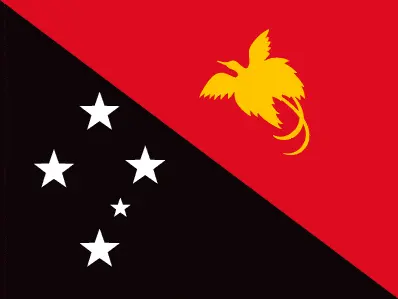
The flag and other symbols of Papua New Guinea
The colors, symbols, and animals on the flag usually have a historical background or an important milestone or memory of the nation.
This case is not an exception either; divided diagonally from the upper hoist-side corner; the upper triangle is red with a soaring yellow bird of paradise centered; the lower triangle is black with five, white, five-pointed stars of the Southern Cross constellation centered; red, black, and yellow are traditional colors of Papua New Guinea; the bird of paradise – endemic to the island of New Guinea – is an emblem of regional tribal culture and represents the emergence of Papua New Guinea as a nation; the Southern Cross, visible in the night sky, symbolizes Papua New Guinea’s connection with Australia and several other countries in the South Pacific.
Apart from the flag, the symbol of national unity is the national anthem. The anthem’s primary purpose is to share the nation’s core values, endeavors, and patriotic feelings.
National symbols of Papua New Guinea: bird of paradise; national colors: red, black.
Constitution of Papua New Guinea
The existence of the nation is based on the constitution. Some constitutions knew worldwide, like the U.S. Constitution that was accepted on the 17th of September 1787, in Philadelphia, the United States of America’s Constitution.
It is not related to the declaration of independence that was stolen by Nicolas Cage in the movie National Treasure 🙂
What is the legal system of Papua New Guinea?
Most of the time, the legal system of a country is the focus of lawyers. It is a common fact that there are two main approaches in the world, “the law in books” and “the law in action.”
In the Anglo-Saxon world, the practice is the “law in action,” while in the rest of the world, the law is based on Roman law, the “law in books.”
The legal system of Papua New Guinea is a mixed legal system of English common law and customary law.
It was Aristotle who founded the Theory of 3 separations of powers. In his view, these are the council of public affairs, the magistrates, and the justice system. The age of enlightenment was the time when terminologies have defined the way we still use them. In most democratic countries, the three authorities separated from each other. In dictatorships, the rules usually interweaved in one hand.
About the legislative branch of Papua New Guinea, we can highlight the following structures unicameral National Parliament (111 seats; members directly elected in single-seat constituencies – 91 local and 20 provincial – by majority preferential vote; members serve 5-year terms); note – the constitution allows up to 126 seats.
About the unemployment rate, labor force, and poverty line in Papua New Guinea
One of the major problems of the 21st-century economy is unemployment. Governments are struggling to maintain a low level of the unemployment rate. Still, as a result of automation, the cheap 3rd world labor, and the outsourcing of workflow, these attempts fail. In Papua New Guinea, the labor force is 4.365 million (2016 estimate). Please bear in mind that the population in Papua New Guinea is total: 37.4 deaths / 1,000 live births; male: 40.9 deaths / 1,000 live births, female: 33.8 deaths / 1,000 live births (2016 estimate) – as we already mentioned above.
The rate of unemployment in Papua New Guinea is 1.9% (2008 estimate).
Widely known that the gap between the rich and poor is widening on an enormous scale.
According to the 2017 shocking Oxfam report, the most affluent eight people’s fortune is equal to the wealth of the poorest half of the world’s population.
In Papua New Guinea, the households’ income and consumption compared to the entire population: lowest 10%: 1.7% highest 10%: 40.5% (1996).
Another widely used indicator is the so-called GINI index, which measures the inequalities of statistical dispersion, but is mainly used for measuring the sharing of income and fortune.
The GINI index was named after its founder Corrado Gini, an Italian economist. Gini index has grades between 0-1, but often it is used on a percentage basis. It is 0 if the examined criteria territorial distribution is equal. It is one of the criteria concentrated on the territory. In Papua New Guinea, the GINI index is .50,9 (1996).
The states usually set up a poverty line, which is more or less, is a subjective measure. It varies by country; its base is often the minimum pension, the incomes of the most deficient 20 percent, the X percent of income per capita Etc.
In Papua New Guinea, the poverty line people are the lowest 10%: 1.7% highest 10%: 40.5% (1996).
About the budget and central governments debt of Papua New Guinea
The available budget mainly defines the state’s economy. The budget of Papua New Guinea is; revenues: $3.169 billion, expenditures: $4.295 billion (2016 estimate). Taxes and other revenues are 15.9% of GDP (2016 estimate).
The budget deficit (Budget surplus (+) or deficit (-)) is N/A.
The fiscal year in Papua New Guinea is the calendar year.
In the country’s economy, we have to consider the public debt. Public debt is the consolidated sum of the state’s local, federal, and central government debt.
Inflation rate and prime lending rate in Papua New Guinea
A few further interesting and relevant economic data are the following; Inflation rate: 6.3% (2016 estimate), 6% (2015 estimate), and the rate of the Commercial bank prime lending rate: 8.3% (31 December 2016 estimate).
Export/import partners and data of Papua New Guinea
With the export of products, industrial tools, and other services, Papua New Guinea generates revenue. The export value in Papua New Guinea is $7.886 billion (2016 estimate), $8.377 billion (2015 estimate). The total revenue of these activities: oil, gold, copper ore, logs, palm oil, coffee, cocoa, crayfish, prawns.
The most important export partners of Papua New Guinea are Japan 17.4%, Australia 15.9%, China 12.1% (2015).
The most important imported products are machinery and transport equipment, manufactured goods, food, fuels, chemicals, and the countries from where the import is coming: Australia 25.9%, China 20%, Singapore 12.6%, Malaysia 7.2%, US 4.2%, Indonesia 4.1%, South Korea 4% (2015).
Renewable energies used in Papua New Guinea
To suppress the pollution of the environment, renewable energies have to replace the fossil energy. The more the proportion of renewable energies in a country means more effort against pollution. Papua New Guinea, the indicator of how much of the country’s produced energy is coming from the hydroelectric source, is 30.9% of total installed capacity (2012 estimate).
To indicate how much another renewable energy produced is 8% of total installed capacity (2012 estimate).
Telecommunication data of Papua New Guinea, calling code
To maintain the economy, the development of a reliable and modern telecommunications infrastructure is crucial. We can say the following about Papua New Guinea; services are minimal; facilities provide radiotelephone and telegraph, coastal radio, aeronautical radio, and international radio communication services domestic: access to telephone services is not widely available although combined fixed-line and mobile-cellular teledensity have increased to roughly 55 per 100 persons. International: country code – 675; submarine cables to Australia and Guam; satellite earth station – 1 Intelsat (Pacific Ocean); international radio communication service (2015).
Transport infrastructure in Papua New Guinea
In the 21st century, we often say that the world has become small and there are no distances anymore. With widespread air travel when (sometimes) there are no visa restrictions, it is easy to reach other countries, but if the distance is not too long, we can also use railway or water transportation.
The number of airports in Papua New Guinea: 561 (2013), and the number of heliports: 2 (2013).
The total length of the roadways in Papua New Guinea: 9,349 km, paved: 3,000 km, unpaved: 6,349 km (2011).
The total length of the waterways in Papua New Guinea: 11,000 km (2011).
Are you traveling to Papua New Guinea?
If you plan to travel by plane to Papua New Guinea, try our air ticket comparison site, where you can choose from hundreds of carriers and offers. Our application is scanning the market and shows you the best and the cheapest deals without any extra charge or commission.
Are you looking for a hotel, apartment another kind of accommodation in Papua New Guinea, Oceania? We are here to help you to find your accommodation from budget to luxury. Our search engine is scanning, regularly updating data from hundreds of accommodation websites and more than a million offers. You can quickly and easily find your hotel stay anywhere in the world, without any extra charge or commission.
Facts & data about Papua New Guinea
Name of the country: conventional long way: Independent State of Papua New Guinea, traditional short form: Papua New Guinea, local short state: Papuaniugini, former: Territory of Papua and New Guineaabbreviation: PNG, etymology: the word “papua” derives from the Malay “papuah” describing the frizzy hair of the Melanesians; Spanish explorer Ynigo ORTIZ de RETEZ applied the term “Nueva Guinea” to the island of New Guinea in 1545 after noting the resemblance of the locals to the peoples of the Guinea coast of Africa.
| Abbreviation: Papua New Guinea | Geographic coordinates: 6 00 S, 147 00 E |
Country Location: Oceania |
| Capital of Papua New Guinea: Port Moresby | GPS of the Capital: 9 27 S 147 11 E |
Position: Oceania, group of islands including the eastern half of the island of New Guinea between the Coral Sea and the South Pacific Ocean, east of Indonesia |
| Land area: total: 462,840 sq km; land: 452,860 sq km, water: 9,980 sq km | Terrain: mostly mountains with coastal lowlands and rolling foothills |
Area comparative: slightly larger than California |
| Population: 6,791,317 (July 2016 estimate) | Population grow rate: 1.75% (2016 estimate) | Sex ratio: at birth: 1.05 male(s) / female, 0-14 years: 1.04 male(s) / female, 15-24 years: 1.03 male(s) / female, 25-54 years: 1.06 male(s) / female, 55-64 years: 1.03 male(s) / female, 65 years and over: 1.06 male(s) / female, total population: 1.04 male(s) / female (2016 estimate) |
| Exports: $7.886 billion (2016 estimate), $8.377 billion (2015 estimate) | Imports: $1.83 billion (2016 estimate), $2.267 billion (2015 estimate) | Import partners: Australia 25.9%, China 20%, Singapore 12.6%, Malaysia 7.2%, US 4.2%, Indonesia 4.1%, South Korea 4% (2015) |
| Urbanization: urban population: 13% of the total population (2015) | Major urban area(s): PORT MORESBY (capital) 345,000 (2015) | Median age: total: 22.9 years; male: 23 years, female: 22.8 years (2016 estimate) |
| Internet users: total: 527,000. Percent of the population: 7.9% (July 2015 estimate) | Telephones (fixed-lines): total subscriptions: 150,000. Subscriptions per 100 inhabitants: 2 (July 2015 estimate) | Telephones (mobile, cellular): total: 3.56 million. Subscriptions per 100 inhabitants: 53 (July 2015 estimate) |
| Unemployment rate: 1.9% (2008 estimate) | Nationality: Papua New Guinean(s) adjective: Papua New Guinean | National holidays: Independence Day, 16 September (1975) |
| Life expectancy at birth: total population: 67.2 years. Male: 65 years, female: 69.5 years (2016 estimate) | Total fertility rate: 3.1 children born / woman (2016 estimate) | Birthrate: 24 births / 1,000 population (2016 estimate) |
| Literacy: age 15 and over can read and write. Total population: 64.2%; male: 65.6%, female: 62.8% (2015 estimate) | Legal system: mixed legal system of English common law and customary law | Suffrage: 18 years of age, universal |
| Industries: copra crushing, palm oil processing, plywood production, wood chip production; mining (gold, silver, copper); crude oil and petroleum products; construction, tourism | Industrial production growth rate: 4.8% (2016 estimate) | GDP real growth rate: 2.5% (2016 estimate) 6.6% (2015 estimate) 7.4% (2014 estimate) |
Do you like this Papua New Guinea Google Maps & country information page?
Please do us a favor: Share or like this page using the icons at the top of the page. We also do encourage you to visit our Facebook page for more travel and country related information.
Many thanks for visiting and sharing this map & country information site!