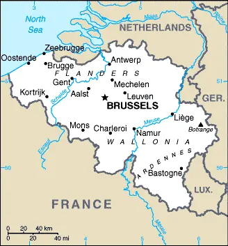
Brussels is one of the most populated cities in Belgium, and at the same time, this city is the capital of this country. Located in Europe, you may find the city easily with the following GPS coordinates: 50.51N latitude / 04.21E longitude. For routing in Brussels, please check the free driving directions Brussels service below.
Belgium
Belgium
Driving Directions Belgium
BELGIUM is a highly industrialized, relatively small country in northwest Europe with a short coastline on the North Sea. It has three topographical regions: the elevated and forested Ardennes plateau, situated in the southeast near the border with France, Luxembourg, and Germany; the rolling, central fertile plains; and the North Sea coastal plain. The Ardennes plateau is an area of moorland, woodlands, and forests, valued for recreational purposes and forestry. The central plains are a fertile agricultural region crossed by Belgium’s principal rivers, the Schelde and Meuse. The coastal plain is low-lying, reaching only about 20 meters or 65 feet above sea level at its highest point.
Belgium Google Map
Google Maps and Detailed Facts of Belgium (BE). This page lets you explore Belgium and its border countries (Country Location: Western Europe, bordering the North Sea, between France and the Netherlands) through detailed Satellite imagery – fast and easy as never before Google Maps.
Find comprehensive information about this country’s diversity below: Google maps, geography, economy, science, people, culture, environment, government, and history – All in One Wiki page.
There is also a Street View and free Driving Directions at your service. Your Google Satellite Map Sightseeing in Belgium, Europe, starts here at Driving Directions and Maps.com.

