
 |
 |
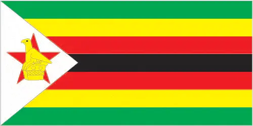 |
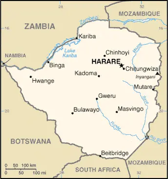
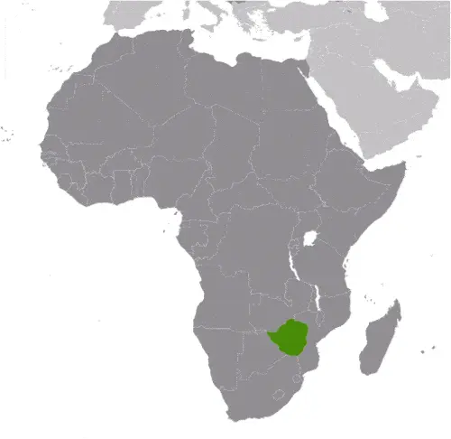
| Borderline map of Zimbabwe | Location map of Zimbabwe | Flag of Zimbabwe |
Google Maps and Detailed Facts of Zimbabwe (ZW). This page lets you explore Zimbabwe and its border countries (Country Location: Southern Africa, between South Africa and Zambia) through detailed Satellite imagery – fast and easy as never before Google Maps.
Find comprehensive information about this country’s diversity below: Google maps, geography, economy, science, people, culture, environment, government, and history – All in One Wiki page.
There is also a Street View and free Driving Directions at your service. Your Google Satellite Map Sightseeing in Zimbabwe, in Africa, starts here at Driving Directions and Maps.com.
Zimbabwe Google Maps & Satellite Maps
The map below shows Zimbabwe with its cities, towns, highways, main roads, streets, and Street Views. To find a location, use the form below, type any city or place, view a simple map, and click the “show map” button.
The Google map above shows Zimbabwe with its location: Africa (geographic coordinates: 20 00 S, 30 00 E) and the international borders of Zimbabwe; total: 3,229 km. Border countries (total: 4): Botswana 834 km, Mozambique 1,402 km, South Africa 230 km, Zambia 763 km; furthermore, it’s inland counties boundaries.
Hint: Look at the Street view in Zimbabwe or Africa. All you have to do is drag and pull the little yellow man (named: Pegman) on the Google map above the desired location. After that, whenever it is available (more than 50 countries globally), blue stripes will appear to show the photos and details from Google’s regularly updated data image base. In case if you have signed in to your Google account currently, you may have a look at the satellite map of this country/area as well.
The map of Zimbabwe, Africa, is for informational use only. No representation is made or warrantied given any map or its content by Driving Directions and Maps site. The user assumes all risks of using this Zimbabwe Google map and facts/wiki.
About Zimbabwe in detail
Where is Zimbabwe?
In case Zimbabwe is looking on the map under the Coordinates 17 49 S 31 02 E otherwise in Africa, in Southern Africa, between South Africa and Zambia.
What is the capital city of Zimbabwe?
The capital city of Zimbabwe is Harare.
What is the time in Harare?
It is 7 hours ahead of Washington, D.C. during Standard Time; Harare’s timezone is UTC+2.
What is the Internet code for Zimbabwe?
The Top Level Domain (TLD) for Zimbabwe is: .zw
What is the size of Zimbabwe?
The territory of Zimbabwe is total: 390,757 sq km; land: 386,847 sq km, water: 3,910 sq km.
If we want to describe the size of the territory of Zimbabwe is slightly larger than Montana.
If we would like to walk around and discover Zimbabwe, we can cover a total distance: 3,229 km.
What is the water coverage of Zimbabwe?
We have already mentioned what percentage of Zimbabwe is covered by water (see below), and this includes 0 km (landlocked country) coastline.
What is the climate like in Zimbabwe?
The climate of Zimbabwe is tropical: moderated by altitude: rainy season (November to March).
Geographical data of Zimbabwe
The elevation of Zimbabwe; mean elevation: 961 m, elevation extremes; lowest point: junction of the Runde and Save Rivers 162 m, highest point: Inyangani 2,592 m.
Zimbabwe’s specific geographical details include mostly high plateau with higher central plateau (high veld); mountains in the east.
Suppose we would like to describe the countries location from a different perspective. In that case, it is safe to say, and easy to read from a map, Zimbabwe is a landlocked country; the Zambezi forms a natural riverine boundary with Zambia; in full flood (February-April), the massive Victoria Falls on the river forms the world’s largest curtain of falling water; Lake Kariba on the Zambia-Zimbabwe border forms the world’s largest reservoir by volume (180 cu km; 43 cu mi).
Resources and land use of Zimbabwe
The country’s main mined products are coal, chromium ore, asbestos, gold, nickel, copper, iron ore, vanadium, lithium, tin, platinum group metals. The population partly uses the earlier highlighted land territory and partly left in its natural state: agricultural land: 42.5%; arable land 10.9%; permanent crops 0.3%; permanent pasture 31.3%; forest: 39.5%; other: 18% (2011 estimate).
Population data of Zimbabwe
The number of inhabitants of Zimbabwe is 14,546,961 (July 2016 estimate).
If we examine the proportion of the population distribution, it is safe to say that N/A.
If we look at the proportion of the urbanized and barely populated areas, these are the figures: urban population: 32.4% of the total population (2015).
Most of the population in Zimbabwe is concentrated in HARARE (capital) 1.501 million (2015).
Ethnicity in Zimbabwe
According to ethnicity details, the ethnic groups are African 99.4% (predominantly Shona; Ndebele is the second largest ethnic group), other 0.4%, unspecified 0.2% (2012 estimate).
Spoken languages in Zimbabwe
The spoken languages in Zimbabwe are the following: Shona (official language; most widely spoken), Ndebele (official language, second most commonly spoken), English (official language; traditionally used for official language business), 13 minority languages (official language; includes Chewa, Chibarwe, Kalanga, Koisan, Nambya, Ndau, Shangani, sign language, Sotho, Tonga, Tswana, Venda, and Xhosa).
What are the most important religions in Zimbabwe?
During the general census, researchers examine the churches, according to this: Protestant 75.9% (includes Apostolic 38%, Pentecostal 21.1%, other 16.8%), Roman Catholic 8.4%, additional Christian 8.4%, other 1.2% (includes traditional, Muslim), none 6.1% (2011 estimate).
Further population data of Zimbabwe
The proportion of gender and age tells a lot about the society as follows 0-14 years: 37.8% (male 2,778,806 / female 2,720,033) 15-24 years: 21.29% (male 1,560,833 / female 1,536,110) 25-54 years: 33.86% (male 2,578,142 / female 2,346,993) 55-64 years: 3.55% (male 188,851 / female 327,483) 65 years and over: 3.5% (male 194,933 / female 314,777) (2016 estimate). It also a significant factor in a society the population growth rate, which in the case of Zimbabwe is 2.2% (2016 estimate).
The population growth rate is based on two elements, the birth, and the death rate. In Zimbabwe the birth rate is 31.9 births / 1,000 population (2016 estimate), the death rate 9.9 deaths / 1,000 population (2016 estimate).
In this day and age in developed societies, the first child borns later compared to the previous centuries and decades, so childbearing is extended. In Zimbabwe, the average age of mothers at the first childbirth is N/A.
Although the children’s birth is postponed in the best-case scenario, the parents can still see their kids grow as life expectancy also extended. In the case of Zimbabwe, these figures are. With the introduction of modern medicine, vaccinations, and the proper hygienic conditions, the infant mortality rate is in a steep decline. The infant mortality statistics in Zimbabwe are the following: N/A. Relevant data is the budget of healthcare, which is in the case of this country is 6.4% of GDP (2014).
Economic data of Zimbabwe
Suppose we would like to describe a country, we also have to mention its economy; Zimbabwe’s economy depends heavily on its mining and agriculture sectors. Following a decade of contraction from 1998 to 2008, the economy recorded real growth of more than 10% per year in 2010-13, before slowing to roughly 4% in 2014. Until early 2009, the Reserve Bank of Zimbabwe (RBZ) routinely printed money to fund the budget deficit, causing hyperinflation. Dollarization in early 2009 – which allowed currencies such as the Botswana pula, the South Africa rand, and the US dollar toZimbabwe’s government entered a second Staff Monitored Program with the IMF in 2014 and undertook other measures to reengage with international financial institutions.
GDP is a prominent figure, as all the relevant calculations and statistics are based on it. GDP in Zimbabwe is $14.19 billion (2015 estimate).
Another important indicator is the rate of GDP growth, which in Zimbabwe is -0.3% (2016 estimate), 1.1% (2015 estimate) 3.9% (2014 estimate).
These statistics affect the world economy; remember, in 2015, the Chinese real GDP growth rate was worse than expected; The world markets fall, and the Chinese stock exchange was temporarily suspended.
A further major factor of a country’s economy, the GDP per capita. In Zimbabwe this is $2,000 (2016 estimate) $2,000 (2015 estimate) $2,000 (2014 estimate).
In the economy, the Trinity is in common places, such as agriculture, industry, and services.
What are the agricultural products Zimbabwe produces?
Zimbabwe’s main agricultural products are tobacco, corn, cotton, wheat, coffee, sugarcane, peanuts; sheep, goats, and pigs.
The essential segments are mining (coal, gold, platinum, copper, nickel, tin, diamonds, clay, numerous metallic and nonmetallic ores), steel; wood products, cement, chemicals, fertilizer, clothing and footwear, foodstuffs, beverages. The crucial and regularly mentioned GDP is based on mining (coal, gold, platinum, copper, nickel, tin, diamonds, clay, numerous metallic and nonmetallic ores), steel; wood products, cement, chemicals, fertilizer, clothing and footwear, foodstuffs, beverages.
Drinking water source in Zimbabwe
It is essential to mention that – thanks to the development of the infrastructure -, the rate of potable water improved: urban: 97% of the population, rural: 67.3% of the people, total: 76.9% of the population. Unimproved: urban: 3% of the population, rural: 32.7% of the population, total: 23.1% of the population (2015 estimate).
The average number of childbirth in Zimbabwe
In Zimbabwe, the average delivery number is 3.5 children born / woman (2016 estimate).
Population, median age, migration, and citizenship in Zimbabwe
The population’s average age is 20.6 years; male: 20.5 years, female: 20.8 years (2016 estimate). The age of adulthood varies in every country of the world in Zimbabwe; it is 18 years of age, universal.
When we are experiencing an unprecedented scale of migration and globalization, it is an important factor in the number of new immigrants. In Zimbabwe is 0 migrant(s) / 1,000 population (2016 estimate). It is important to know how to apply for citizenship: citizenship by birth: no. Citizenship by descent only: the father must be a citizen of Zimbabwe; in the case of a child born out of wedlock, the mother must be a citizen. Dual citizenship recognized: no—the residency requirement for naturalization: 5 years.
Is Zimbabwe a safe destination? Healthcare services and infectious diseases in Zimbabwe
Many of the travelers are looking into the healthcare services and infectious diseases of their destinations. In Zimbabwe, the hospital beds’ density is 1.7 beds / 1,000 population (2011).
According to the WHO rating regarding Zimbabwe’s contagious diseases, the degree of risk: high food or waterborne diseases: bacterial and protozoal diarrhea, hepatitis A, and typhoid fever vectorborne diseases: malaria and dengue fever water contact disease: schistosomiasis. Animal contact disease: rabies, (2016).
However, HIV is not curable but maintainable. Let’s do not forget when the disease surfaced; it was a world threatening condition. Unfortunately, in some countries, it is still very high the number of infected patients and fatalities due to the disease.
In Zimbabwe, the number of HIV/AIDS deaths: N/A.
Regarding tourism obesity, not an important issue, but we have to mention health statistics, as it is the plague of the 20th and the 21st century. The rate of obese adults in Zimbabwe is 8.4% (2014).
What are the natural hazards in Zimbabwe? Is there any?
The most known natural risk in Zimbabwe are recurring droughts; floods and severe storms are rare.
More interesting facts about Zimbabwe
Like every country and society, a few words about the past are connected to its history; The UK annexed Southern Rhodesia from the former British South Africa Company in 1923. A 1961 constitution was formulated that favored whites in power. In 1965 the government unilaterally declared its independence, but the UK did not recognize the act and demanded more complete voting rights for the black African majority (then called Rhodesia). UN sanctions and a guerrilla uprising finally led to free elections in 1979 and independence (as Zimbabwe) in 1980. Robert MUGABE, the nation’s first prime minister, has been the country’s only ruler (as president since 1987) and has dominated the country’s political system since independence. His chaotic land redistribution campaign began in 1997 and intensified after 2000, caused an exodus of white farmers, crippled the economy, and ushered in widespread shortages of basic commodities.
Ignoring international condemnation, MUGABE rigged the 2002 presidential election to ensure his reelection. In April 2005, the capital city of Harare embarked on Operation Restore Order, ostensibly an urban rationalization program, which destroyed the homes or businesses of 700,000 mostly poor supporters of the opposition. MUGABE in June 2007 instituted price controls on all basic commodities, causing panic buying and leaving store shelves empty for months. General elections held in March 2008 contained irregularities but still amounted to a censure of the ZANU-PF-led government, with the opposition winning a majority of seats in parliament. Movement for Democratic Change – Tsvangirai opposition leader Morgan TSVANGIRAI won the most votes in the presidential poll, but not enough to win outright. In the lead up to a run-off election in June 2008, considerable violence against opposition party members led to the withdrawal of TSVANGIRAI from the ballot. Extensive evidence of violence and intimidation resulted in international condemnation of the process. Difficult negotiations over a power-sharing “government of national unity,” in which MUGABE remained president and TSVANGIRAI became prime minister, were finally settled in February 2009. However, the leaders disagreed on many key outstanding governmental issues.
MUGABE was reelected president in June 2013 in balloting that was severely flawed and internationally condemned. As a prerequisite to holding the election, Zimbabwe enacted a new constitution by referendum, although many new constitution provisions have yet to be codified in law.
In every nation’s memory, some cornerstones placed the country on the timeline of history. The date of declaration of independence of Zimbabwe: 18 April 1980 (from the UK).
The flag and other symbols of Zimbabwe
The colors, symbols, and animals on the flag usually have a historical background or an important milestone or memory of the nation.
This case is not an exception either; seven equal horizontal bands of green, yellow, red, black, red, yellow, and green with a white isosceles triangle edged in black with its base on the hoist side; a yellow Zimbabwe bird representing the long history of the country is superimposed on a red five-pointed star in the center of the triangle, which symbolizes peace; green represents agriculture, yellow mineral wealth, red the bloodshed to achieve independence, and black stands for the native people.
Apart from the flag, the symbol of national unity is the national anthem. The anthem’s primary purpose is to share the nation’s core values, endeavors, and patriotic feelings.
National symbols of Zimbabwe: Zimbabwe bird symbol, African fish eagle, flame lily; national colors: green, yellow, red, black, white.
Constitution of Zimbabwe
The existence of the nation is based on the constitution. Some constitutions knew worldwide, like the U.S. Constitution that was accepted on the 17th of September 1787, in Philadelphia, the United States of America’s Constitution.
It is not related to the declaration of independence that was stolen by Nicolas Cage in the movie National Treasure 🙂
What is the legal system of Zimbabwe?
Most of the time, the legal system of a country is the focus of lawyers. It is a common fact that there are two main approaches in the world, “the law in books” and “the law in action.”
In the Anglo-Saxon world, the practice is the “law in action,” while in the rest of the world, the law is based on Roman law, the “law in books.”
Zimbabwe’s legal system is a mixed legal system of English common law, Roman-Dutch civil law, and customary law.
It was Aristotle who founded the Theory of 3 separations of powers. In his view, these are the council of public affairs, the magistrates, and the justice system. The age of enlightenment was the time when terminologies have defined the way we still use them. In most democratic countries, the three authorities separated from each other. In dictatorships, the rules usually interweaved in one hand.
About the legislative branch of Zimbabwe, we can highlight the following structures bicameral Parliament consists of the Senate (80 seats; 60 members directly elected in multi-seat constituencies – 6 seats in each of the ten provinces – by proportional representation vote, 16 indirectly elected by the regional governing councils, 2 reserved for the National Council Chiefs, and 2 reserved for members with disabilities; members serve 5-year terms) and the House of Assembly (270 seats; 210 members directly elected in single-seat constituencies by simple majority vote and 60 seats reserved for women directly elected by proportional representation vote; members serve 5-year terms).
About the unemployment rate, labor force, and poverty line in Zimbabwe
One of the major problems of the 21st-century economy is unemployment. Governments are struggling to maintain a low level of the unemployment rate. Still, as a result of automation, the cheap 3rd world labor, and the outsourcing of workflow, these attempts fail. In Zimbabwe, the labor force is 8.098 million (2016 estimate). Please bear in mind that the population in Zimbabwe is total: 25.9 deaths / 1,000 live births; male: 28.1 deaths / 1,000 live births, female: 23.6 deaths / 1,000 live births (2016 estimate) – as we already mentioned above.
The rate of unemployment in Zimbabwe is 95% (2009 estimate).
Widely known that the gap between the rich and poor is widening on an enormous scale.
According to the 2017 shocking Oxfam report, the most affluent eight people’s fortune is equal to the wealth of the poorest half of the world’s population.
In Zimbabwe, the households’ income and consumption compared to the entire population: lowest 10%: 2% highest 10%: 40.4% (1995).
Another widely used indicator is the so-called GINI index, which measures the inequalities of statistical dispersion, but is mainly used for measuring the sharing of income and fortune.
The GINI index was named after its founder Corrado Gini, an Italian economist. Gini index has grades between 0-1, but often it is used on a percentage basis. It is 0 if the examined criteria territorial distribution is equal. It is one of the criteria concentrated on the territory. In Zimbabwe, the GINI index is .50,1 (2006).
The states usually set up a poverty line, which is more or less, is a subjective measure. It varies by country; its base is often the minimum pension, the incomes of the most deficient 20 percent, the X percent of income per capita Etc.
In Zimbabwe, the poverty line people are the lowest 10%: 2% highest 10%: 40.4% (1995).
About the budget and central governments debt of Zimbabwe
The available budget mainly defines the state’s economy. Zimbabwe’s budget is; revenues: $3.4 billion, expenditures: $3.9 billion (2016 estimate). Taxes and other revenues are 24% of GDP (2016 estimate).
The budget deficit (Budget surplus (+) or deficit (-)) is N/A.
The fiscal year in Zimbabwe is the calendar year.
In the country’s economy, we have to consider the public debt. Public debt is the consolidated sum of the state’s local, federal, and central government debt.
Inflation rate and prime lending rate in Zimbabwe
A few further interesting and relevant economic data are the following; Inflation rate: 1.6% (2016 estimate), -2.4% (2015 estimate), and the rate of the Commercial bank prime lending rate: 20% (31 December 2016 estimate).
Export/import partners and data of Zimbabwe
Zimbabwe, with the export of products, industrial tools, and other services, generates revenue. Zimbabwe’s export value is: $3.257 billion (2016 estimate), $3.551 billion (2015 estimate). The total revenue of these activities: platinum, cotton, tobacco, gold, ferroalloys, textiles/clothing.
The most important export partners of Zimbabwe are China 27.8%, the Democratic Republic of the Congo 14%, Botswana 12.5%, South Africa 7.6% (2015).
The most important imported products are machinery and transport equipment, other manufactures, chemicals, fuels, food products, and the countries from where the import is coming: South Africa 48.1%, China 12.1%, India 5.2%, Zambia 4.6% (2015).
Renewable energies used in Zimbabwe
To suppress the pollution of the environment, renewable energies have to replace the fossil energy. The more the proportion of renewable energies in a country means more effort against pollution. Zimbabwe, the indicator of how much of the country’s produced energy is coming from the hydroelectric source, is 36.8% of total installed capacity (2012 estimate).
To indicate how much another renewable energy produced is 0% of total installed capacity (2012 estimate).
Telecommunication data of Zimbabwe, calling code
To maintain the economy, the development of a reliable and modern telecommunications infrastructure is crucial. We can say the following about Zimbabwe; privatization and competition have driven the rapid expansion of telecommunications, particularly cellular voice, and mobile broadband, in recent years; continued economic instability and infrastructure limitations, such as reliable power, hinder progress. Domestic: consists of microwave radio relay links, open-wire lines, radiotelephone communication stations, fixed wireless local loop installations, fiber-optic cable, VSAT terminals, and a substantial mobile-cellular network; Internet connection is most readily ava international: country code – 263; satellite earth stations – 2 Intelsat; 5 international digital gateway exchanges; fiber-optic connections to neighboring states provide access to international networks via undersea cable (2015).
Transport infrastructure in Zimbabwe
In the 21st century, we often say that the world has become small and there are no distances anymore. With widespread air travel when (sometimes) there are no visa restrictions, it is easy to reach other countries, but if the distance is not too long, we can also use railway or water transportation.
The number of airports in Zimbabwe: 196 (2013), and the number of heliports: N/A.
The total length of the roadways in Zimbabwe: total: 97,267 km, paved: 18,481 km, unpaved: 78,786 km (2002).
The total length of the waterways in Zimbabwe: (some navigation possible on Lake Kariba) (2011).
Are you traveling to Zimbabwe?
If you plan to travel by plane to Zimbabwe, try our air ticket comparison site, where you can choose from hundreds of carriers and offers. Our application is scanning the market and shows you the best and the cheapest deals without any extra charge or commission.
Are you looking for a hotel, apartment another kind of accommodation in Zimbabwe, Africa? We are here to help you to find your accommodation from budget to luxury. Our search engine is scanning, regularly updating data from hundreds of accommodation websites and more than a million offers. You can quickly and easily find your hotel stay anywhere in the world, without any extra charge or commission.
Facts & data about Zimbabwe
Name of the country: conventional long way: the Republic of Zimbabwe, traditional short form: Zimbabwe, former: Southern Rhodesia, Rhodesia, etymology: takes its name from the Kingdom of Zimbabwe (13th-15th century), and it’s capital of Great Zimbabwe, the largest stone structure in pre-colonial southern Africa.
| Abbreviation: Zimbabwe | Geographic coordinates: 20 00 S, 30 00 E |
Country Location: Africa |
| Capital of Zimbabwe: Harare | GPS of the Capital: 17 49 S 31 02 E |
Position: Southern Africa, between South Africa and Zambia |
| Land area: total: 390,757 sq km; land: 386,847 sq km, water: 3,910 sq km | Terrain: mostly high plateau with higher central plateau (high veld); mountains in east |
Area comparative: slightly larger than Montana |
| Population: 14,546,961 (July 2016 estimate) | Population grow rate: 2.2% (2016 estimate) | Sex ratio: at birth: 1.03 male(s) / female, 0-14 years: 1.02 male(s) / female, 15-24 years: 1.02 male(s) / female, 25-54 years: 1.1 male(s) / female, 55-64 years: 0.58 male(s) / female, 65 years and over: 0.64 male(s) / female, total population: 1.01 male(s) / female (2016 estimate) |
| Exports: $3.257 billion (2016 estimate), $3.551 billion (2015 estimate) | Imports: $5.738 billion (2016 estimate), $6.016 billion (2015 estimate) | Import partners: South Africa 48.1%, China 12.1%, India 5.2%, Zambia 4.6% (2015) |
| Urbanization: urban population: 32.4% of the total population (2015) | Major urban area(s): HARARE (capital) 1.501 million (2015) | Median age: total: 20.6 years; male: 20.5 years, female: 20.8 years (2016 estimate) |
| Internet users: total: 2.328 million. Percent of the population: 16.4% (July 2015 estimate) | Telephones (fixed-lines): total subscriptions: 333,702. Subscriptions per 100 inhabitants: 2 (July 2015 estimate) | Telephones (mobile, cellular): total: 12.757 million. Subscriptions per 100 inhabitants: 90 (July 2015 estimate) |
| Unemployment rate: 95% (2009 estimate) | Nationality: Zimbabwean(s) adjective: Zimbabwean | National holidays: Independence Day, 18 April (1980) |
| Life expectancy at birth: total population: 58 years. Male: 57.3 years, female: 58.7 years (2016 estimate) | Total fertility rate: 3.5 children born / woman (2016 estimate) | Birthrate: 31.9 births / 1,000 population (2016 estimate) |
| Literacy: age 15 and over can read and write English. Total population: 86.5%; male: 88.5%, female: 84.6% (2015 estimate) | Legal system: mixed legal system of English common law, Roman-Dutch civil law, and customary law | Suffrage: 18 years of age, universal |
| Industries: mining (coal, gold, platinum, copper, nickel, tin, diamonds, clay, numerous metallic and nonmetallic ores), steel; wood products, cement, chemicals, fertilizer, clothing and footwear, foodstuffs, beverages | Industrial production growth rate: -3% (2016 estimate) | GDP real growth rate: -0.3% (2016 estimate) 1.1% (2015 estimate) 3.9% (2014 estimate) |
Do you like this Zimbabwe Google maps™ & country information page?
Please do us a favor: Share or like this page using the icons at the top of the page. We also do encourage you to visit our Facebook page for more travel and country related information.
Many thanks for visiting and sharing this map & country information site!