
 |
 |
 |
| Borderline map of Uruguay | Location map of Uruguay | Flag of Uruguay |
Google Maps and Detailed Facts of Uruguay (UY). This page lets you explore Uruguay and its border countries (Country Location: Southern South America, bordering the South Atlantic Ocean, between Argentina and Brazil) through detailed Satellite imagery – fast and easy as never before Google Maps.
Find comprehensive information about this country’s diversity below: Google Maps, geography, economy, science, people, culture, environment, government, and history – All in One Wiki page.
There is also a Street View and free Driving Directions at your service. Your Google Satellite Map Sightseeing in Uruguay, in South America, starts here at Driving Directions and Maps.com.
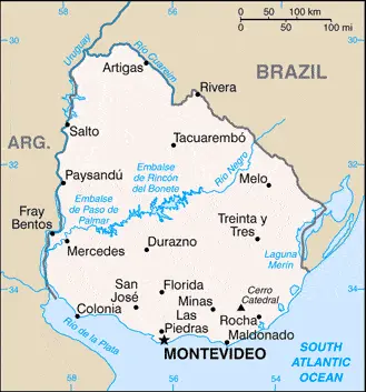
Uruguay Google Maps & Satellite Maps
The map below shows Uruguay with its cities, towns, highways, main roads, streets, and Street Views. To find a location, use the form below, type any city or place, view a simple map, and click the “show map” button.
The Google Maps above shows Uruguay with its location: South America (geographic coordinates: 33 00 S, 56 00 W) and the international borders of Uruguay; total: 1,591 km. Border countries (total: 2): Argentina 541 km, Brazil 1,050 km; furthermore, it’s inland counties boundaries.
Hint: Look at the Street view in Uruguay or South America. All you have to do is drag and pull the little yellow man (named: Pegman) on the Google Maps above the desired location. After that, whenever it is available (more than 50 countries globally), blue stripes will appear to show the photos and details from Google’s regularly updated data image base. In case if you have signed in to your Google account currently, you may have a look at the satellite map of this country/area as well.
The map of Uruguay, South America, is for informational use only. No representation is made or warrantied given any map or its content by Driving Directions and Maps site. The user assumes all risks of using this Uruguay Google Maps and facts/wiki.
About Uruguay in detail
Where is Uruguay?
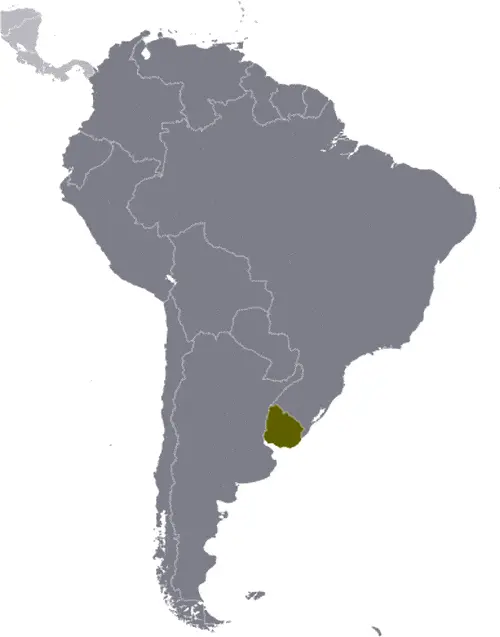
In case, Uruguay is looking on the map under the Coordinates 34 51 S 56 10 W otherwise in South America, in Southern South America, bordering the South Atlantic Ocean, between Argentina and Brazil.
What is the capital city of Uruguay?
The capital city of Uruguay is Montevideo.
What is the time in Montevideo?
It is 2 hours ahead of Washington, D.C. during Standard Time; Montevideo’s timezone is UTC-3.
What is the Internet code for Uruguay?
The Top Level Domain (TLD) for Uruguay is: .uy
What is the size of Uruguay?
The territory of Uruguay is total: 176,215 sq km; land: 175,015 sq km, water: 1,200 sq km.
If we want to describe the size of Uruguay’s territory is somewhat smaller than the state of Washington.
If we would like to walk around and discover Uruguay, we can cover a total distance: 1,591 km.
What is the water coverage of Uruguay?
We have already mentioned what Uruguay percentage is covered by water (see below), and this includes 660 km coastline.
What is the climate like in Uruguay?
The climate of Uruguay is warm temperate: freezing temperatures almost unknown.
Geographical data of Uruguay
Uruguay elevation; mean elevation: 109 m, elevation extremes; lowest point: Atlantic Ocean 0 m, highest point: Cerro Catedral 514 m.
The specific geographical details of Uruguay include mostly rolling plains and low hills; fertile coastal lowland.
Suppose we would like to describe the countries location from a different perspective. In that case, it is safe to say, and easy to read from a map, Uruguay is the second-smallest South American country (after Suriname); most of the low-lying landscape (three-quarters of the country) is grassland, ideal for cattle and sheep raising.
Resources and land use of Uruguay
The country’s main mined products are arable land, hydropower, minor minerals, fish. The population partly uses the earlier highlighted land territory and partly left in its natural state: agricultural land: 87.2%; arable land 10.1%; permanent crops 0.2%; permanent pasture 76.9%; forest: 10.2%; other: 2.6% (2011 estimate).
Population data of Uruguay
The number of inhabitants of Uruguay is 3,351,016 (July 2016 estimate).
If we examine the proportion of the population distribution, it is safe to say that most of the country’s population resides in the southern half of the country; approximately 80% of the populace is urban, living in towns or cities; nearly half of the population lives in and around the capital of Montevideo.
If we look at the proportion of the urbanized and barely populated areas, these are the figures: urban population: 95.3% of the total population (2015).
Most of the population in Uruguay is concentrated in MONTEVIDEO (capital) 1.707 million (2015).
Ethnicity in Uruguay
According to ethnicity details, the ethnic groups are white 88%, mestizo 8%, black 4%, Amerindian (practically nonexistent).
Uruguay’s spoken languages are the following: Spanish (official language), Portunol, Brazilero (Portuguese-Spanish mix on the Brazilian frontier).
What are the most important religions in Uruguay?
According to this, during the general census, researchers examine the churches: Roman Catholic 47.1%, non-Catholic Christians 11.1%, nondenominational 23.2%, Jewish 0.3%, atheist or agnostic 17.2%, other 1.1% (2006).
Further population data of Uruguay
The proportion of gender and age tells a lot about the society as follows 0-14 years: 20.44% (male 348,547 / female 336,435) 15-24 years: 15.78% (male 267,848 / female 260,990) 25-54 years: 39.23% (male 649,702 / female 664,933) 55-64 years: 10.41% (male 164,201 / female 184,784) 65 years and over: 14.13% (male 189,197 / female 284,379) (2016 estimate). It also a significant factor in a society the population growth rate, which in the case of Uruguay is 0.27% (2016 estimate).
The population growth rate is based on two elements, the birth, and the death rate. In Uruguay the birth rate is 13 births / 1,000 population (2016 estimate), the death rate 9.4 deaths / 1,000 population (2016 estimate).
In this day and age in developed societies, the first child borns later compared to the previous centuries and decades, so childbearing is extended. In Uruguay, the average age of mothers at the first childbirth is N/A.
Although the children’s birth is postponed in the best-case scenario, the parents can still see their kids grow as life expectancy also extended. In the case of Uruguay, these figures are. With the introduction of modern medicine, vaccinations, and the proper hygienic conditions, the infant mortality rate is in a steep decline. The infant mortality statistics in Uruguay are the following: N/A. Relevant data is the budget of healthcare, which is in the case of this country is 8.6% of GDP (2014).
Economic data of Uruguay
Suppose we would like to describe a country. We also have to mention its economy; Uruguay has a free-market economy characterized by an export-oriented agricultural sector, a well-educated workforce, and high social spending levels. Uruguay has sought to expand trade within the Common Market of the South (Mercosur). With non-MercFollowing financial difficulties in the late 1990s and early 2000s, Uruguay’s economic growth averaged 8% annually during 2004-08. The 2008-09 global financial crisis put a brake on Uruguay’s vigorous growth, which decelerated to 2.6% in 2009.
GDP is a prominent figure, as all the relevant calculations and statistics are based on it. GDP in Uruguay is $54.37 billion (2015 estimate).
Another important indicator is the rate of GDP growth, which in Uruguay is 0.1% (2016 estimate), 1% (2015 estimate) 3.2% (2014 estimate).
These statistics affect the world economy; remember, in 2015, the Chinese real GDP growth rate was worse than expected; The world markets fall, and the Chinese stock exchange was temporarily suspended.
A further major factor of a country’s economy, the GDP per capita. In Uruguay this is $21,600 (2016 estimate) $21,600 (2015 estimate) $21,500 (2014 estimate).
In the economy, the Trinity is in common places, such as agriculture, industry, and services.
What are the agricultural products Uruguay produces?
Uruguay’s main agricultural products are soybeans, rice, wheat; beef, dairy products; fish; lumber, cellulose.
The essential segments are food processing, electrical machinery, transportation equipment, petroleum products, textiles, chemicals, and beverages. The crucial and regularly mentioned GDP is based on food processing, electrical machinery, transportation equipment, petroleum products, materials, chemicals, beverages.
Drinking water source in Uruguay
It is essential to mention that – thanks to the development of the infrastructure -, the rate of potable water improved: urban: 100% of the population, rural: 93.9% of the population, total: 99.7% of the population. Unimproved: urban: 0% of the population, rural: 6.1% of the population, total: 0.3% of the population (2015 estimate).
The average number of childbirth in Uruguay
In Uruguay, the average delivery number is 1.81 children born / woman (2016 estimate).
Population, median age, migration, and citizenship in Uruguay
The population’s average age is 34.7 years; male: 33 years, female: 36.4 years (2016 estimate). The age of adulthood varies in every country of the world in Uruguay; it is 18 years of age, universal and compulsory.
When we are experiencing an unprecedented scale of migration and globalization, it is an important factor in the number of new immigrants. In Uruguay is -0.9 migrant(s) / 1,000 population (2016 estimate). It is important to know how to apply for citizenship: citizenship by birth: yes. Citizenship by descent: yes. Dual citizenship recognized: yes, the residency requirement for naturalization: 3-5 years.
Is Uruguay a safe destination? Healthcare services and infectious diseases in Uruguay
Many of the travelers are looking into the healthcare services and infectious diseases of their destinations. In Uruguay, the hospital beds’ density is 2.5 beds / 1,000 population (2012).
According to the WHO rating regarding contagious diseases in Uruguay: N/A.
However, HIV is not curable but maintainable. Let’s do not forget when the disease surfaced; it was a world threatening condition. Unfortunately, in some countries, it is still very high the number of infected patients and fatalities due to the disease.
In Uruguay, the number of HIV/AIDS deaths: N/A.
Regarding tourism obesity, not an important issue, but we have to mention health statistics, as it is the plague of the 20th and the 21st century. The rate of obese adults in Uruguay is 27.6% (2014).
What are the natural hazards in Uruguay? Is there any?
The most known natural risk in Uruguay are seasonally high winds (the pampero is a chilly and occasional violent wind that blows north from the Argentine pampas), droughts, floods; because of the absence of mountains, which act as weather barriers, all locations are particularly vulnerable to rapid changes from weather fronts.
More interesting facts about Uruguay
A few words about the past, as every country and society, is connected to its history; Montevideo, founded by the Spanish in 1726 as a military stronghold, soon took advantage of its natural harbor to become an important commercial center. Claimed by Argentina but annexed by Brazil in 1821, Uruguay declared its independence four years later and secured its freedom in 1828 after a three-year struggle. The administrations of President Jose BATLLE in the early 20th century launched widespread political, social, and economic reforms that established a statist tradition.
A violent Marxist urban guerrilla movement named the Tupamaros, launched in the late 1960s, led Uruguay’s president to cede control of the government to the military in 1973. By yearend, the rebels had been crushed, but the military continued to expand its hold over the government. Civilian rule was not restored until 1985. In 2004, the left-of-center Frente Amplio Coalition won national elections that effectively ended 170 years of political control previously held by the Colorado and Blanco parties. Uruguay’s political and labor conditions are among the freest on the continent.
In every nation’s memory, some cornerstones placed the country on the timeline of history. The date of declaration of independence of Uruguay: 25 August 1825 (from Brazil).
The flag and other symbols of Uruguay
The colors, symbols, and animals on the flag usually have a historical background or an important milestone or memory of the nation.
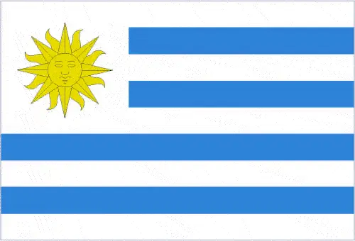
This case is not an exception either; nine equal horizontal stripes of white (top and bottom) alternating with blue; a white square in the upper hoist-side corner with a yellow sun bearing a human face known as the Sun of May with 16 rays that alternate between triangular and wavy; the stripes represent the nine original departments of Uruguay; the sun symbol evokes the legend of the sun breaking through the clouds on 25 May 1810 as independence was first declared from Spain (Uruguay subsequently won its independence from Brazil); the sun features are said to represent those of Inti, the Inca god of the sun. Note: the banner was inspired by Argentina’s national colors and by the design of the US flag.
Apart from the flag, the symbol of national unity is the national anthem. The anthem’s primary purpose is to share the nation’s core values, endeavors, and patriotic feelings.
Uruguay’s national symbols: Sun of May (a sun-with-face symbol); national colors: blue, white, yellow.
Constitution of Uruguay
The existence of the nation is based on the constitution. Some constitutions knew worldwide, like the U.S. Constitution that was accepted on the 17th of September 1787, in Philadelphia, the United States of America’s Constitution.
It is not related to the declaration of independence that was stolen by Nicolas Cage in the movie National Treasure 🙂
What is the legal system of Uruguay?
Most of the time, the legal system of a country is the focus of lawyers. It is a common fact that there are two main approaches in the world, “the law in books” and “the law in action.”
In the Anglo-Saxon world, the practice is the “law in action,” while in the rest of the world, the law is based on Roman law, the “law in books.”
The legal system of Uruguay is a civil law system based on the Spanish civil code.
It was Aristotle who founded the Theory of 3 separations of powers. In his view, these are the council of public affairs, the magistrates, and the justice system. The age of enlightenment was the time when terminologies have defined the way we still use them. In most democratic countries, the three authorities separated from each other. In dictatorships, the rules usually interweaved in one hand.
About the legislative branch of Uruguay, we can highlight the following structures bicameral General Assembly or Asamblea General consists of the Chamber of Senators or Camara de Senadores (31 seats; members directly elected in a single nationwide constituency by proportional representation vote; the vice-president serves as the presiding ex-officio member; elected members serve 5-year terms) and the Chamber of Representatives or Camara de Representantes (99 seats; members directly elected in multi-seat constituencies by proportional representation vote to serve 5-year terms).
About the unemployment rate, labor force, and poverty line in Uruguay
One of the major problems of the 21st-century economy is unemployment. Governments are struggling to maintain a low level of the unemployment rate. Still, as a result of automation, the cheap 3rd world labor, and the outsourcing of workflow, these attempts fail. In Uruguay, the labor force is 1.736 million (2016 estimate). Please bear in mind that the population in Uruguay is total: 8.5 deaths / 1,000 live births; male: 9.5 deaths / 1,000 live births, female: 7.6 deaths / 1,000 live births (2016 estimate) – as we already mentioned above.
The rate of unemployment in Uruguay is 7.6% (2016 estimate).
Widely known that the gap between the rich and poor is widening on an enormous scale.
According to the 2017 shocking Oxfam report, the most affluent eight people’s fortune is equal to the wealth of the poorest half of the world’s population.
In Uruguay, the households’ income and consumption compared to the entire population: lowest 10%: 1.9% highest 10%: 34.4% (2010 estimate).
Another widely used indicator is the so-called GINI index, which measures the inequalities of statistical dispersion, but is mainly used for measuring the sharing of income and fortune.
The GINI index was named after its founder Corrado Gini, an Italian economist. Gini index has grades between 0-1, but often it is used on a percentage basis. It is 0 if the examined criteria territorial distribution is equal. It is one of the criteria concentrated on the territory. In Uruguay, the GINI index is .45,3 (2010).
The states usually set up a poverty line, which is more or less, is a subjective measure. It varies by country; its base is often the minimum pension, the incomes of the most deficient 20 percent, the X percent of income per capita Etc.
In Uruguay, the poverty line people are the lowest 10%: 1.9% highest 10%: 34.4% (2010 estimate).
About the budget and central governments debt of Uruguay
The available budget mainly defines the state’s economy. Uruguay’s budget is; revenues: $14.29 billion, expenditures: $15.9 billion (2016 estimate). Taxes and other revenues are 26.3% of GDP (2016 estimate).
The budget deficit (Budget surplus (+) or deficit (-)) is N/A.
The fiscal year in Uruguay is the calendar year.
In the country’s economy, we have to consider the public debt. Public debt is the consolidated sum of the state’s local, federal, and central government debt.
Inflation rate and prime lending rate in Uruguay
A few further interesting and relevant economic data are the following; Inflation rate: 10.2% (2016 estimate), 8.7% (2015 estimate), and the rate of the Commercial bank prime lending rate: 15.5% (31 December 2016 estimate).
Export/import partners and data of Uruguay
Uruguay, with the export of products, industrial tools, and other services, generates revenue. Uruguay’s export value is $9.042 billion (2016 estimate), $9.067 billion (2015 estimate). The total revenue of these activities: beef, soybeans, cellulose, rice, wheat, wood, dairy products, wool.
Uruguay’s most important export partners are China 15%, Brazil 14.4%, US 6.5%, Argentina 4.9% (2015).
The most important imported products are refined oil, crude oil, passenger and other vehicles, vehicle parts, cellular phones, and the countries from where the import is coming: Brazil 18.2%, China 17.4%, Argentina 12.6%, US 9.1%, Germany 4.5%, Nigeria 4.1% (2015).
Renewable energies used in Uruguay
To suppress the pollution of the environment, renewable energies have to replace the fossil energy. The more the proportion of renewable energies in a country means more effort against pollution. Uruguay, the indicator of how much of the country’s produced energy is coming from the hydroelectric source, is 53.6% of total installed capacity (2012 estimate).
To indicate how much another renewable energy produced is 2% of total installed capacity (2012 estimate).
Telecommunication data of Uruguay, calling code
To maintain the economy, the development of a reliable and modern telecommunications infrastructure is crucial. We can say the following about Uruguay; fully digitalized. Domestic: most modern facilities concentrated in Montevideo; nationwide microwave radio relay network; overall fixed-line and mobile-cellular teledensity over 195 telephones per 100 persons. International: country code – 598; the UNISOR submarine cable system provides direct connectivity to Brazil and Argentina; satellite earth stations – 2 Intelsat (Atlantic Ocean) (2015).
Transport infrastructure in Uruguay
In the 21st century, we often say that the world has become small and there are no distances anymore. With widespread air travel when (sometimes) there are no visa restrictions, it is easy to reach other countries, but if the distance is not too long, we can also use railway or water transportation.
The number of airports in Uruguay: 133 (2013), and the number of heliports: N/A.
The total length of the roadways in Uruguay: total: 77,732 km, paved: 7,743 km, unpaved: 69,989 km (2010).
The total length of the waterways in Uruguay: 1,600 km (2011).
Are you traveling to Uruguay?
If you plan to travel by plane to Uruguay, try our air ticket comparison site, where you can choose from hundreds of carriers and offers. Our application is scanning the market and shows you the best and the cheapest deals without any extra charge or commission.
Are you looking for a hotel, apartment another kind of accommodation in Uruguay, South America? We are here to help you to find your accommodation from budget to luxury. Our search engine is scanning, regularly updating data from hundreds of accommodation websites and more than a million offers. You can quickly and easily find your hotel stay anywhere in the world, without any extra charge or commission.
Facts & data about Uruguay
Name of the country: conventional long way: the Oriental Republic of Uruguay, traditional short form: Uruguay, local long form: Republica Oriental del Uruguay, local short state: Uruguay, former: Banda Oriental, Cisplatine Province, etymology: the Guarani Indians named the Uruguay River, which makes up the western border of the country and whose name later came to be applied to the entire country.
| Abbreviation: Uruguay | Geographic coordinates: 33 00 S, 56 00 W |
Country Location: South America |
| Capital of Uruguay: Montevideo | GPS of the Capital: 34 51 S 56 10 W |
Position: Southern South America, bordering the South Atlantic Ocean, between Argentina and Brazil |
| Land area: total: 176,215 sq km; land: 175,015 sq km, water: 1,200 sq km | Terrain: mostly rolling plains and low hills; fertile coastal lowland |
Area comparative: somewhat smaller than the state of Washington |
| Population: 3,351,016 (July 2016 estimate) | Population grow rate: 0.27% (2016 estimate) | Sex ratio: at birth: 1.04 male(s) / female, 0-14 years: 1.04 male(s) / female, 15-24 years: 1.03 male(s) / female, 25-54 years: 0.98 male(s) / female, 55-64 years: 0.89 male(s) / female, 65 years and over: 0.66 male(s) / female, total population: 0.94 male(s) / female (2016 estimate) |
| Exports: $9.042 billion (2016 estimate), $9.067 billion (2015 estimate) | Imports: $9.075 billion (2016 estimate), $9.345 billion (2015 estimate) | Import partners: Brazil 18.2%, China 17.4%, Argentina 12.6%, US 9.1%, Germany 4.5%, Nigeria 4.1% (2015) |
| Urbanization: urban population: 95.3% of the total population (2015) | Major urban area(s): MONTEVIDEO (capital) 1.707 million (2015) | Median age: total: 34.7 years; male: 33 years, female: 36.4 years (2016 estimate) |
| Internet users: total: 2.159 million. Percent of the population: 64.6% (July 2015 estimate) | Telephones (fixed-lines): total subscriptions: 1,106,431. Subscriptions per 100 inhabitants: 33 (July 2015 estimate) | Telephones (mobile, cellular): total: 5.495 million. Subscriptions per 100 inhabitants: 164 (July 2015 estimate) |
| Unemployment rate: 7.6% (2016 estimate) | Nationality: Uruguayan(s) adjective: Uruguayan | National holidays: Independence Day, 25 August (1825) |
| Life expectancy at birth: total population: 77.2 years. Male: 74.1 years, female: 80.5 years (2016 estimate) | Total fertility rate: 1.81 children born / woman (2016 estimate) | Birthrate: 13 births / 1,000 population (2016 estimate) |
| Literacy: age 15 and over can read and write. Total population: 98.5%; male: 98.2%, female: 98.8% (2015 estimate) | Legal system: civil law system based on the Spanish civil code | Suffrage: 18 years of age, universal and compulsory |
| Industries: food processing, electrical machinery, transportation equipment, petroleum products, textiles, chemicals, beverages | Industrial production growth rate: 3.5% (2016 estimate) | GDP real growth rate: 0.1% (2016 estimate) 1% (2015 estimate) 3.2% (2014 estimate) |
Do you like this Uruguay Google Maps & country information page?
Please do us a favor: Share or like this page using the icons at the top of the page. We also do encourage you to visit our Facebook page for more travel and country related information.
Many thanks for visiting and sharing this map & country information site!