
 |
 |
 |
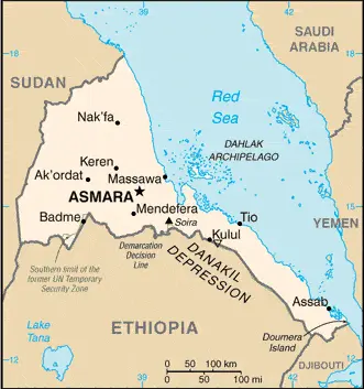
| Borderline map of Eritrea | Location map of Eritrea | Flag of Eritrea |
Google Maps and Detailed Facts of Eritrea (ER). This page lets you explore Eritrea and its border countries (Country Location: Eastern Africa, bordering the Red Sea, between Djibouti and Sudan) through detailed Satellite imagery – fast and easy as never before Google Maps.
Find comprehensive information about this country’s diversity below: Google maps, geography, economy, science, people, culture, environment, government, and history – All in One Wiki page.
There is also a Street View and free Driving Directions at your service. Your Google Satellite Map Sightseeing in Eritrea, in Africa, starts here at Driving Directions and Maps.com.
Eritrea Google Maps & Satellite Maps
The map below shows Eritrea with its cities, towns, highways, main roads, streets, and Street Views. To find a location, use the form below, type any city or place, view a simple map, and click the “show map” button.
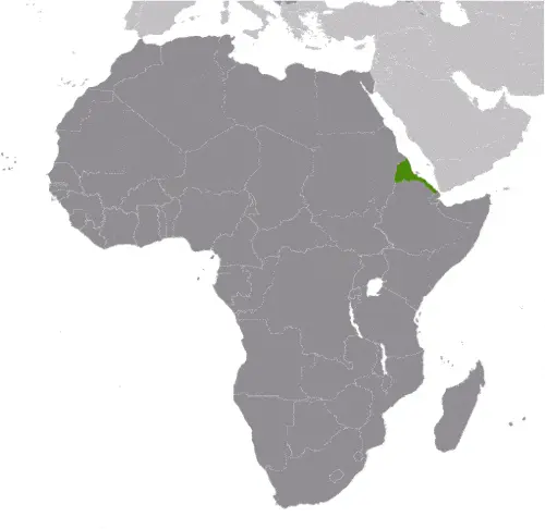
The Google map above shows Eritrea with its location: Africa (geographic coordinates: 15 00 N, 39 00 E) and the international borders of Eritrea; total: 1,840 km. Border countries (total: 3): Djibouti 125 km, Ethiopia 1,033 km, Sudan 682 km; furthermore, it’s inland counties boundaries.
Hint: Look at the Street view in Eritrea or Africa. All you have to do is drag and pull the little yellow man (named: Pegman) on the Google map above the desired location. After that, whenever it is available (more than 50 countries globally), blue stripes will appear to show the photos and details from Google’s regularly updated data image base. In case if you have signed in to your Google account currently, you may have a look at the satellite map of this country/area as well.
The map of Eritrea, Africa, is for informational use only. No representation is made or warrantied given any map or its content by Driving Directions and Maps site. The user assumes all risks of using this Eritrea Google map and facts/wiki.
About Eritrea in detail
Where is Eritrea?
Eritrea, in case, if you are looking on the map under the Coordinates 15 20 N 38 56 E otherwise in Africa, in Eastern Africa, bordering the Red Sea, between Djibouti and Sudan.
What is the capital city of Eritrea?
The capital city of Eritrea is Asmara.
What is the time in Asmara?
It is 8 hours ahead of Washington, D.C. during Standard Time; the timezone of Asmara is UTC+3.
What is the Internet code for Eritrea?
The Top Level Domain (TLD) for Eritrea is: .er
What is the size of Eritrea?
The territory of Eritrea is total: 117,600 sq km; land: 101,000 sq km, water: 16,600 sq km.
If we want to describe the size of the territory of Eritrea is slightly larger than Pennsylvania.
If we would like to walk around and discover Eritrea, we can cover a total distance: 1,840 km.
What is the water coverage of Eritrea?
We have already mentioned what percentage of Eritrea is covered by water (see below), and this includes 2,234 km (mainland on the Red Sea 1,151 km, islands in Red Sea 1,083 km) coastline.
What is the climate like in Eritrea?
Eritrea’s climate is hot, a desert strip along the Red Sea coast: cooler and wetter in the central highlands (up to 61 cm of rainfall annually, heaviest June to September): semiarid in western hills and lowlands.
Geographical data of Eritrea
Eritrea’s elevation; mean elevation: 853 m, elevation extremes; lowest point: near Kulul within the Danakil Depression -75 m, highest point: Soira 3,018 m.
Eritrea’s specific geographical details include the extension of Ethiopian north-south trending highlands, descending on the east to a coastal desert plain, on the northwest to hilly terrain and the southwest flat-to-rolling plains.
Suppose we would like to describe the countries location from a different perspective. In that case, it is safe to say, and easy to read from a map, Eritrea is a strategic geopolitical position along the world’s busiest shipping lanes; Eritrea retained the entire coastline of Ethiopia along the Red Sea upon de jure independence from Ethiopia on 24 May 1993.
Resources and land use of Eritrea
The country’s main mined products are gold, potash, zinc, copper, salt, oil and natural gas, and fish. The population partly uses the earlier highlighted land territory and partly left in its natural state: agricultural land: 75.1%; arable land 6.8%; permanent crops 0%; permanent pasture 68.3%; forest: 15.1%; other: 9.8% (2011 estimate).
Population data of Eritrea
The number of inhabitants of Eritrea is 5,869,869 (July 2016 estimate).
If we examine the proportion of the population distribution, it is safe to say that N/A.
If we look at the proportion of the urbanized and barely populated areas, these are the figures: urban population: 22.6% of the total population (2015).
Most of the population in Eritrea is concentrated in ASMARA (capital) 804,000 (2015).
Ethnicity in Eritrea
According to ethnicity details, the ethnic groups are nine recognized ethnic groups: Tigrinya 55%, Tigre 30%, Saho 4%, Kunama 2%, Rashaida 2%, Bilen 2%, other (Afar, Beni Amir, Nera) 5% (2010 estimate).
Spoken languages in Eritrea
The spoken languages in Eritrea are the following: Tigrinya (official language), Arabic (official language), English (official language), Tigre, Kunama, Afar, other Cushitic languages.
What are the most important religions in Eritrea?
According to this, during the general census, researchers examine the churches: Muslim, Coptic Christian, Roman Catholic, Protestant.
Further population data of Eritrea
The proportion of gender and age tells a lot about the society as follows 0-14 years: 40.66% (male 1,199,355 / female 1,187,467) 15-24 years: 19.39% (male 566,199 / female 571,743) 25-54 years: 32.33% (male 933,825 / female 963,812) 55-64 years: 3.73% (male 93,325 / female 125,411) 65 years and over: 3.9% (male 97,248 / female 131,484) (2016 estimate). It also a significant factor in a society the population growth rate, which in the case of Eritrea is 0.81% (2016 estimate).
The population growth rate is based on two elements, the birth, and the death rate. In Eritrea the birth rate is 30.1 births / 1,000 population (2016 estimate), the death rate 7.3 deaths / 1,000 population (2016 estimate).
In this day and age in developed societies, the first child borns later compared to the previous centuries and decades, so childbearing is extended. In Eritrea, the average age of mothers at the first childbirth is N/A.
Although the children’s birth is postponed in the best-case scenario, the parents can still see their kids grow as life expectancy also extended. In the case of Eritrea, these figures are. With the introduction of modern medicine, vaccinations, and the proper hygienic conditions, the infant mortality rate is in a steep decline. The infant mortality statistics in Eritrea are the following: N/A. Relevant data is the budget of healthcare, which is in this country’s case is 3.3% of GDP (2014).
Economic data of Eritrea
Suppose we would like to describe a country, we also have to mention its economy; since Ethiopia’s formal independence in 1993, Eritrea has faced many economic problems, including lack of financial resources and chronic drought, which have been exacerbated by restrictive economic policies. Since the conclusion of the Ethiopia-Eritrea war in 2000, the government has expanded the use of military and party-owned businesses to complete President ISAIAS’s development agenda. The government has strictly controlled the use of foreign currency by limitations. While reliable statistics on food security are difficult to obtain, erratic rainfall and the percentage of the labor force tied up in national service continue to interfere with agricultural production and economic development.
GDP is a prominent figure, as all the relevant calculations and statistics are based on it. GDP in Eritrea is $5.352 billion (2015 estimate).
Another important indicator is the rate of GDP growth, which in Eritrea is 3.7% (2016 estimate), 4.8% (2015 estimate) 5% (2014 estimate).
These statistics affect the world economy; remember, in 2015, the Chinese real GDP growth rate was worse than expected; The world markets fall, and the Chinese stock exchange was temporarily suspended.
A further major factor of a country’s economy, the GDP per capita. In Eritrea this is $1,300 (2016 estimate) $1,300 (2015 estimate) $1,300 (2014 estimate).
In the economy, the Trinity is in common places, such as agriculture, industry, and services.
What are the agricultural products Eritrea produces?
Eritrea’s main agricultural products are sorghum, lentils, vegetables, corn, cotton, tobacco, sisal, livestock, goats, fish.
The essential segments are food processing, beverages, clothing and textiles, light manufacturing, salt, cement. The crucial and regularly mentioned GDP is based on food processing, beverages, clothing and textiles, light manufacturing, salt, cement.
Drinking water source in Eritrea
It is essential to mention that – thanks to the development of the infrastructure -, the rate of potable water improved: urban: 73.2% of the population, rural: 53.3% of the people, total: 57.8% of the community. Unimproved: urban: 26.8% of the people, rural: 46.7% of the population, total: 42.2% of the population (2015 estimate).
The average number of childbirth in Eritrea
In Eritrea, the average delivery number is 4.07 children born / woman (2016 estimate).
Population, median age, migration, and citizenship in Eritrea
The population’s average age is 19.4 years; male: 19 years, female: 19.9 years (2016 estimate). The age of adulthood varies in every country of the world in Eritrea; it is 18 years of age, universal.
When we are experiencing an unprecedented scale of migration and globalization, it is an important factor in the number of new immigrants. In Eritrea is -14.7 migrant(s) / 1,000 population (2016 estimate). It is important to know how to apply for citizenship: citizenship by birth: no. Citizenship by descent only: at least one parent must be a citizen of Eritrea. Dual citizenship recognized: no—residency requirement for naturalization: 20 years.
Is Eritrea a safe destination? Healthcare services and infectious diseases in Eritrea
Many of the travelers are looking into the healthcare services and infectious diseases of their destinations. In Eritrea, the hospital beds’ density is 0.7 beds / 1,000 population (2011).
According to the WHO rating regarding contagious diseases in Eritrea, high food or waterborne diseases: bacterial diarrhea, hepatitis A, and typhoid fever vectorborne diseases: malaria and dengue fever (2016).
However, HIV is not curable but maintainable. Let’s do not forget when the disease surfaced; it was a world threatening condition. Unfortunately, in some countries, it is still very high the number of infected patients and fatalities due to the disease.
In Eritrea, the number of HIV/AIDS deaths: N/A.
Regarding tourism obesity, not an important issue, but we have to mention health statistics, as it is the plague of the 20th and the 21st century. The rate of obese adults in Eritrea is 3.4% (2014).
What are the natural hazards in Eritrea? Is there any?
Eritrea’s most known natural risks are frequent droughts, rare earthquakes, and volcanoes, locust swarms. Volcanism: Dubbi (elevation 1,625 m), which last erupted in 1861, was the country’s only historically active volcano until Nabro (2,218 m) came to life on 12 June 2011.
More interesting facts about Eritrea
A few words about the past, as every country and society, are connected to its history; After independence from Italian colonial control in 1941 and 10 years of British administrative rule, the UN established Eritrea as an autonomous region Ethiopian federation in 1952. Ethiopia’s full annexation of Eritrea as a province ten years later sparked a violent 30-year struggle for independence that ended in 1991 with Eritrean rebels defeating government forces. Eritreans overwhelmingly approved independence in a 1993 referendum. ISAIAS Afworki has been Eritrea’s only president since independence; his rule, mainly since 2001, has been highly autocratic and repressive. His government has created a highly militarized society by pursuing an unpopular mandatory conscription program into national service, sometimes of indefinite length. A two-and-a-half-year border war with Ethiopia that erupted in 1998 ended under UN auspices in December 2000. A UN peacekeeping operation was established that monitored a 25 km-wide Temporary Security Zone.
The Eritrea-Ethiopia Boundary Commission (EEBC) created in April 2003 was tasked “to delimit and demarcate the colonial treaty border based on pertinent colonial treaties (1900, 1902, and 1908) and applicable international law.” The EEBC on 30 November 2007 remotely demarcated the border, assigning the town of Badme to Eritrea, despite Ethiopia’s maintaining forces there from the time of the 1998-2000 war. Eritrea insisted that the UN terminate its peacekeeping mission on 31 July 2008. Eritrea has accepted the EEBC’s “virtual demarcation” decision and repeatedly called on Ethiopia to remove its troops. Ethiopia has not accepted the demarcation decision, and neither party has entered into meaningful dialogue to resolve the impasse. Eritrea is subject to several UN Security Council Resolutions (from 2009, 2011, and 2012) imposing various military and economic sanctions because of evidence that it has supported armed opposition groups in the region.
In every nation’s memory, some cornerstones placed the country on the timeline of history. The date of declaration of independence of Eritrea: 24 May 1993 (from Ethiopia).
The flag and other symbols of Eritrea
The colors, symbols, and animals on the flag usually have a historical background or an important milestone or memory of the nation.
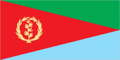
This case is not an exception either; red isosceles triangle (based on the hoist side) dividing the flag into two right triangles; the upper triangle is green, the lower one is blue; a gold wreath encircling a gold olive branch is centered on the hoist side of the red triangle; green stands for the country’s agriculture economy, red signifies the bloodshed in the fight for freedom, and blue symbolizes the bounty of the sea; the wreath-olive branch symbol is similar to that on the first flag of Eritrea from 1952; the shape of the red triangle broadly mimics the shape of the country. Note: one of several flags where a prominent component of the design reflects the country’s shape; other such flags are Bosnia and Herzegovina, Brazil, and Vanuatu.
Apart from the flag, the symbol of national unity is the national anthem. The anthem’s primary purpose is to share the nation’s core values, endeavors, and patriotic feelings.
National symbols of Eritrea: camel; national colors: green, red, blue.
Constitution of Eritrea
The existence of the nation is based on the constitution. Some constitutions knew worldwide, like the U.S. Constitution that was accepted on the 17th of September 1787, in Philadelphia, the United States of America’s Constitution.
It is not related to the declaration of independence that was stolen by Nicolas Cage in the movie National Treasure 🙂
What is the legal system of Eritrea?
Most of the time, the legal system of a country is the focus of lawyers. It is a common fact that there are two main approaches in the world, “the law in books” and “the law in action.”
In the Anglo-Saxon world, the practice is the “law in action,” while in the rest of the world, the law is based on Roman law, the “law in books.”
Eritrea’s legal system is a mixed legal system of civil, customary, and Islamic religious law.
It was Aristotle who founded the Theory of 3 separations of powers. In his view, these are the council of public affairs, the magistrates, and the justice system. The age of enlightenment was the time when terminologies have defined the way we still use them. In most democratic countries, the three authorities separated from each other. In dictatorships, the rules usually interweaved in one hand.
About the legislative branch of Eritrea, we can highlight the following structures unicameral National Assembly or Hagerawi Baito (150 seats; 75 members indirectly elected by the ruling party and 75 directly elected by simple majority vote; members serve 5-year terms)elections: in May 1997, following the adoption of the new constitution, 75 members of the PFDJ Central Committee (the old Central Committee of the EPLF), 60 members of the 527-member Constituent Assembly, which had been established in 1997 to discuss and ratify the new constitution, and 15 representatives of Eritreans living abroad were formed into a Transitional National Assembly to serve as the country’s legislative body until countrywide elections to form a National Assembly were held; although only 75 of 150 members of the Transitional National Assembly were elected, the constitution stipulates that once past the transition stage, all members of the National Assembly will be elected by secret ballot of all eligible voters; National Assembly elections scheduled for December 2001 were postponed indefinitely due to the war with Ethiopia.
About the unemployment rate, labor force, and poverty line in Eritrea
One of the major problems of the 21st-century economy is unemployment. Governments are struggling to maintain a low level of the unemployment rate. Still, as a result of automation, the cheap 3rd world labor, and the outsourcing of workflow, these attempts fail. In Eritrea, the labor force is 2.62 million (2016 estimate). Please bear in mind that the population in Eritrea is total: 45.6 deaths / 1,000 live births; male: 52.6 deaths / 1,000 live births, female: 38.5 deaths / 1,000 live births (2016 estimate) – as we already mentioned above.
The rate of unemployment in Eritrea is 8.6% (2013 estimate).
Widely known that the gap between the rich and poor is widening on an enormous scale.
According to the 2017 shocking Oxfam report, the most affluent eight people’s fortune is equal to the wealth of the poorest half of the world’s population.
In Eritrea, the households’ income and consumption compared to the entire population: lowest 10%: N/A% highest 10%: N/A%.
Another widely used indicator is the so-called GINI index, which measures the inequalities of statistical dispersion, but is mainly used for measuring the sharing of income and fortune.
The GINI index was named after its founder Corrado Gini, an Italian economist. Gini index has grades between 0-1, but often it is used on a percentage basis. It is 0 if the examined criteria territorial distribution is equal. It is one of the criteria concentrated on the territory. In Eritrea, the GINI index is N/A.
The states usually set up a poverty line, which is more or less, is a subjective measure. It varies by country; its base is often the minimum pension, the incomes of the most deficient 20 percent, the X percent of income per capita Etc.
In Eritrea, the poverty line people are the lowest 10%: N/A% highest 10%: N/A%.
About the budget and central governments debt of Eritrea
The available budget mainly defines the state’s economy. Eritrea’s budget is; revenues: $1.58 billion, expenditures: $2.165 billion (2016 estimate). Taxes and other revenues are 29.5% of GDP (2016 estimate).
The budget deficit (Budget surplus (+) or deficit (-)) is N/A.
The fiscal year in Eritrea is the calendar year.
In the country’s economy, we have to consider the public debt. Public debt is the consolidated sum of the state’s local, federal, and central government debt.
Inflation rate and prime lending rate in Eritrea
A few further interesting and relevant economic data are the following; Inflation rate: 11.8% (2016 estimate), 9.8% (2015 estimate), and the commercial bank prime lending rate: N/A%.
Export/import partners and data of Eritrea
Eritrea, with the export of products, industrial tools, and other services, generates revenue. The export value in Eritrea is: $485.2 million (2016 estimate), $415.3 million (2015 estimate). The total revenue of these activities: gold and other minerals, livestock, sorghum, textiles, food, the small industry manufacturers.
The most important export partners of Eritrea are N/A.
The most important imported products are machinery, petroleum products, food, manufactured goods, and the countries from where the import is coming: N/A.
Renewable energies used in Eritrea
To suppress the pollution of the environment, renewable energies have to replace the fossil energy. The more the proportion of renewable energies in a country means more effort against pollution. Eritrea, the indicator of how much of the country’s produced energy is coming from the hydroelectric source, is 0% of total installed capacity (2012 estimate).
To indicate how much another renewable energy produced is 1.3% of total installed capacity (2012 estimate).
Telecommunication data of Eritrea, calling code
To maintain the economy, the development of a reliable and modern telecommunications infrastructure is crucial. We can say the following about Eritrea; woefully inadequate service provided by state-owned telecom monopoly; most fixed-line telephones are in Asmara; cell phone use only slowly increasing throughout the country. Domestic: combined fixed-line and mobile-cellular subscribership is less than 10 per 100 persons. International: country code – 291 (2015).
Transport infrastructure in Eritrea
In the 21st century, we often say that the world has become small and there are no distances anymore. With widespread air travel when (sometimes) there are no visa restrictions, it is easy to reach other countries, but if the distance is not too long, we can also use railway or water transportation.
The number of airports in Eritrea: 13 (2013), and the number of heliports: 1 (2013).
The total length of the roadways in Eritrea: total: 4,010 km, paved: 874 km, unpaved: 3,136 km (2000).
The total length of the waterways in Eritrea: N/A.
Are you traveling to Eritrea?
If you plan to travel by plane to Eritrea, try our air ticket comparison site, where you can choose from hundreds of carriers and offers. Our application is scanning the market and shows you the best and the cheapest deals without any extra charge or commission.
Are you looking for a hotel, apartment another kind of accommodation in Eritrea, Africa? We are here to help you to find your accommodation from budget to luxury. Our search engine is scanning, regularly updating data from hundreds of accommodation websites and more than a million offers. You can quickly and easily find your hotel stay anywhere in the world, without any extra charge or commission.
Facts & data about Eritrea
Name of the country: conventional long way: the State of Eritrea, traditional short form: Eritrea, local long form: Hagere Ertra, local short state: Ertra, former: Eritrea Autonomous Region in Ethiopia, etymology: the country name derives from the ancient Greek appellation “Erythra Thalassa” meaning the Red Sea, which is the significant water body bordering the country.
| Abbreviation: Eritrea | Geographic coordinates: 15 00 N, 39 00 E |
Country Location: Africa |
| Capital of Eritrea: Asmara | GPS of the Capital: 15 20 N 38 56 E |
Position: Eastern Africa, bordering the Red Sea, between Djibouti and Sudan |
| Land area: total: 117,600 sq km; land: 101,000 sq km, water: 16,600 sq km | Terrain: dominated by extension of Ethiopian north-south trending highlands, descending on the east to a coastal desert plain, on the northwest to hilly terrain and on the southwest to flat-to-rolling plains |
Area comparative: slightly larger than Pennsylvania |
| Population: 5,869,869 (July 2016 estimate) | Population grow rate: 0.81% (2016 estimate) | Sex ratio: at birth: 1.03 male(s) / female, 0-14 years: 1.01 male(s) / female, 15-24 years: 0.99 male(s) / female, 25-54 years: 0.97 male(s) / female, 55-64 years: 0.74 male(s) / female, 65 years and over: 0.75 male(s) / female, total population: 0.97 male(s) / female (2016 estimate) |
| Exports: $485.2 million (2016 estimate), $415.3 million (2015 estimate) | Imports: $1.022 billion (2016 estimate), $1.024 billion (2015 estimate) | Import partners: N/A |
| Urbanization: urban population: 22.6% of the total population (2015) | Major urban area(s): ASMARA (capital) 804,000 (2015) | Median age: total: 19.4 years; male: 19 years, female: 19.9 years (2016 estimate) |
| Internet users: total: 71,000. Percent of the population: 1.1% (July 2015 estimate) | Telephones (fixed-lines): total subscriptions: 66,000. Subscriptions per 100 inhabitants: 1 (July 2015 estimate) | Telephones (mobile, cellular): total: 475,000. Subscriptions per 100 inhabitants: 7 (July 2015 estimate) |
| Unemployment rate: 8.6% (2013 estimate) | Nationality: Eritrean(s) adjective: Eritrean | National holidays: Independence Day, 24 May (1991) |
| Life expectancy at birth: total population: 64.9 years. Male: 62.4 years, female: 67.5 years (2016 estimate) | Total fertility rate: 4.07 children born / woman (2016 estimate) | Birthrate: 30.1 births / 1,000 population (2016 estimate) |
| Literacy: age 15 and over can read and write. Total population: 73.8%; male: 82.4%, female: 65.5% (2015 estimate) | Legal system: mixed legal system of civil, customary, and Islamic religious law | Suffrage: 18 years of age, universal |
| Industries: food processing, beverages, clothing and textiles, light manufacturing, salt, cement | Industrial production growth rate: 12.2% (2016 estimate) | GDP real growth rate: 3.7% (2016 estimate) 4.8% (2015 estimate) 5% (2014 estimate) |
Do you like this Eritrea Google maps™ & country information page?
Please do us a favor: Share or like this page using the icons at the top of the page. We also do encourage you to visit our Facebook page for more travel and country related information.
Many thanks for visiting and sharing this map & country information site!