
 |
 |
 |
| Borderline map of Colombia | Location map of Colombia | Flag of Colombia |
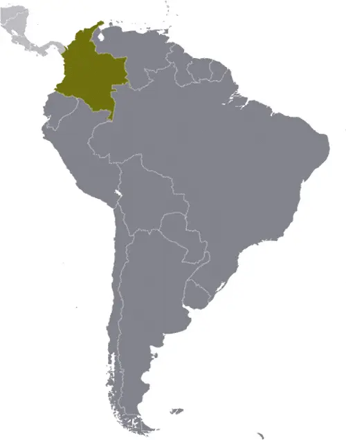
Google Maps and Detailed Facts of Colombia (CO). This page lets you explore Colombia and its border countries (Country Location: Northern South America, bordering the Caribbean Sea, between Panama and Venezuela, and bordering the North Pacific Ocean, between Ecuador and Panama) through detailed Satellite imagery – fast and easy as never before Google Maps.
Find comprehensive information about this country’s diversity below: Google maps, geography, economy, science, people, culture, environment, government, and history – All in One Wiki page.
There is also a Street View and free Driving Directions at your service. Your Google Satellite Map Sightseeing in Colombia, in South America, starts here at Driving Directions and Maps.com.
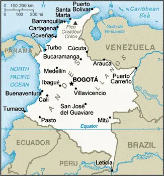
Colombia Google Maps & Satellite Maps
The map below shows Colombia with its cities, towns, highways, main roads, streets, and Street Views. To find a location, use the form below, type any city or place, view a simple map, and click the “show map” button.
The Google map above shows Colombia with its location: South America (geographic coordinates: 4 00 N, 72 00 W) and the international borders of Colombia; total: 6,672 km. Border countries (total: 5): Brazil 1,790 km, Ecuador 708 km, Panama 339 km, Peru 1,494 km, Venezuela 2,341 km; furthermore, it’s inland counties boundaries.
Hint: Look at the Street view in Colombia or South America. All you have to do is drag and pull the little yellow man (named: Pegman) on the Google map above the desired location. After that, whenever it is available (more than 50 countries globally), blue stripes will appear to show the photos and details from Google’s regularly updated data image base. In case if you have signed in to your Google account currently, you may have a look at the satellite map of this country/area as well.
The map of Colombia, South America, is for informational use only. No representation is made or warrantied given any map or its content by Driving Directions and Maps site. The user assumes all risks of using this Colombia Google map and facts/wiki.
About Colombia in detail
Where is Colombia?
Colombia, in case if you are looking on the map under the Coordinates 4 36 N 74 05 W otherwise in South America, in Northern South America, bordering the Caribbean Sea, between Panama and Venezuela, and bordering the North Pacific Ocean, between Ecuador and Panama.
What is the capital city of Colombia?
The capital city of Colombia is Bogota.
What is the time in Bogota?
It is the same time as Washington, D.C., during Standard Time; Bogota’s timezone is UTC-5.
What is the Internet code for Colombia?
The Top Level Domain (TLD) for Colombia is: .co
What is the size of Colombia?
The territory of Colombia is total: 1,138,910 sq km; land: 1,038,700 sq km, water: 100,210 sq km.
If we want to describe Colombia’s territory’s size, it is slightly less than twice Texas’s size.
If we would like to walk around and discover Colombia, we can cover a total distance: 6,672 km.
What is the water coverage of Colombia?
We have already mentioned what percentage of Colombia is covered by water (see below), which includes 3,208 km (the Caribbean Sea 1,760 km, North Pacific Ocean 1,448 km) coastline.
What is the climate like in Colombia?
The climate of Colombia is tropical along the coast and eastern plains: cooler in highlands.
Geographical data of Colombia
The elevation of Colombia; mean elevation: 593 m, elevation extremes; lowest point: Pacific Ocean 0 m, highest point: Pico Cristobal Colon 5,775 m.
The specific geographical details of Colombia include flat coastal lowlands, central highlands, high Andes Mountains, eastern lowland plains (Llanos).
Suppose we would like to describe the countries location from a different perspective. In that case, it is safe to say and easy to read from a map, Colombia is the only South American country with coastlines on both the North Pacific Ocean and the Caribbean Sea.
Resources and land use of Colombia
The country’s main mined products are petroleum, natural gas, coal, iron ore, nickel, gold, copper, emeralds, hydropower. The population partly uses the earlier highlighted land territory and partly left in its natural state: agricultural land: 37.5%; arable land 1.4%; permanent crops 1.6%; permanent pasture 34.5%; forest: 54.4%; other: 8.1% (2011 estimate).
Population data of Colombia
The number of inhabitants of Colombia is 47,220,856 (July 2016 estimate).
If we examine the proportion of the population distribution, it is safe to say that the majority of people live in the north and west where agricultural opportunities and natural resources are found; the vast grasslands of the llanos to the south and east, which make up approximately 60% of the country, are sparsely populated.
If we look at the proportion of the urbanized and barely populated areas, these are the figures: urban population: 76.4% of the total population (2015).
Most of the Colombia population is concentrated in BOGOTA (capital) 9.765 million; Medellin 3.911 million; Cali 2.646 million; Barranquilla 1.991 million; Bucaramanga 1.215 million; Cartagena 1.092 million (2015).
Ethnicity in Colombia
According to ethnicity details, the ethnic groups are mestizo and white 84.2%, Afro-Colombian (includes multatto, Raizal, and Palenquero) 10.4%, Amerindian 3.4%, Roma.
Spoken languages in Colombia
The spoken languages in Colombia are the following: Spanish (official language).
What are the most important religions in Colombia?
Researchers examine the churches: Roman Catholic 90%, other 10% during the general census.
Further population data of Colombia
The proportion of gender and age tells a lot about the society as follows 0-14 years: 24.57% (male 5,940,903 / female 5,659,594) 15-24 years: 17.54% (male 4,216,437 / female 4,066,079) 25-54 years: 41.82% (male 9,788,057 / female 9,958,982) 55-64 years: 8.9% (male 1,973,215 / female 2,230,609) 65 years and over: 7.17% (male 1,412,209 / female 1,974,771) (2016 estimate). It also a significant factor in a society the population growth rate, which in the case of Colombia is 1.02% (2016 estimate).
The population growth rate is based on two elements, the birth and the death rate. In Colombia the birth rate is 16.3 births / 1,000 population (2016 estimate), the death rate 5.4 deaths / 1,000 population (2016 estimate).
In this day and age in developed societies, the first child borns later compared to the previous centuries and decades, so childbearing is extended. In Colombia, the average age of mothers at the first childbirth is N/A.
Although the children’s birth is postponed in the best-case scenario, the parents can still see their kids grow as life expectancy also extended. In the case of Colombia, these figures are. With the introduction of modern medicine, vaccinations, and the proper hygienic conditions, the infant mortality rate is in a steep decline. The infant mortality statistics in Colombia are the following: N/A. Relevant data is the budget of healthcare, which is in the case of this country, is 7.2% of GDP (2014).
Economic data of Colombia
Suppose we would like to describe a country. We also have to mention its economy; Colombia’s consistently sound economic policies and aggressive promotion of free trade agreements have bolstered its ability to weather external shocks. Colombia depends heavily on energy and mining exports, making it vulnerable to a drop in Declining oil prices, resulting in a decline in government revenues. In 2014, Colombia passed a tax reform bill to offset the lost income from the global drop in oil prices. The SANTOS administration is also using tax reform to help finance implementation despite austerity measures by the SANTOS administration. GDP and foreign direct investment fell in 2015, while the El Nino weather phenomenon caused food and energy prices to rise, with inflation spiking to 6.8%. To combat inflation, Real GDP growth averaged 4.8% per year from 2010-2014, continuing a decade of strong economic performance before dropping in 2015. All three major rating agencies upgraded Colombia’s government debt to investment grade in 2013 and 2014, which helped the SANTOS Administration’s foreign policy focus on bolstering Colombia’s commercial ties and boosting investment at home. Colombia has signed or is negotiating Free Trade Agreements (FTA) with more than a dozen countries.
GDP is a prominent figure, as all the relevant calculations and statistics are based on it. GDP in Colombia is $274.1 billion (2015 estimate).
Another important indicator is the rate of GDP growth, which in Colombia is 2.2% (2016 estimate), 3.1% (2015 estimate) 4.4% (2014 estimate).
These statistics affect the world economy; remember, in 2015, the Chinese real GDP growth rate was worse than expected; The world markets fall, and the Chinese stock exchange is temporally suspended.
A further major factor of a country’s economy, the GDP per capita. In Colombia this is $14,200 (2016 estimate) $14,000 (2015 estimate) $13,800 (2014 estimate).
In the economy, the Trinity is in common places, such as agriculture, industry, and services.
What are the agricultural products Colombia produces?
The main agricultural products of Colombia are coffee, cut flowers, bananas, rice, tobacco, corn, sugarcane, cocoa beans, oilseed, vegetables, shrimp, forest products.
The crucial segments are textiles, food processing, oil, clothing and footwear, beverages, chemicals, cement, gold, coal, emeralds. The critical and regularly mentioned GDP is based on textiles, food processing, oil, clothing and footwear, beverages, chemicals, cement, gold, coal, emeralds.
Drinking water source in Colombia
It is essential to mention that – thanks to the development of the infrastructure -, the rate of potable water improved: urban: 96.8% of the population, rural: 73.8% of the people, total: 91.4% of the community. Unimproved: urban: 3.2% of the people, rural: 26.2% of the population, total: 8.6% of the population (2015 estimate).
The average number of childbirth in Colombia
In Colombia, the average delivery number is 2.02 children born / woman (2016 estimate).
Population, median age, migration, and citizenship in Colombia
The population’s average age is 29.6 years; male: 28.7 years, female: 30.6 years (2016 estimate). The age of adulthood varies in every country of the world. In Colombia, it is 18 years of age, universal.
When we are experiencing an unprecedented scale of migration and globalization, it is an important factor in the number of new immigrants. In Colombia is -0.6 migrant(s) / 1,000 population (2016 estimate). It is important to know how to apply for citizenship: citizenship by birth: no. Citizenship by descent only: At least one parent must be a citizen or permanent resident of Colombia. Dual citizenship recognized: yes, the residency requirement for naturalization: 5 years.
Is Colombia a safe destination? Healthcare services and infectious diseases in Colombia
Many of the travelers are looking into the healthcare services and infectious diseases of their destinations. In Colombia, the hospital beds’ density is 1.5 beds / 1,000 population (2012).
According to the WHO rating regarding contagious diseases in Colombia, the degree of risk: high food or waterborne diseases: bacterial diarrhea vectorborne diseases: dengue fever, malaria, and yellow fever. Note: active local transmission of Zika virus by Aedes species mosquitoes has been identified in this country (as of August 2016); it poses a significant risk (a large number of cases possible) among US citizens if bitten by an infective mosquito; other less common ways to get Zika are through sex, via blood transfusion, or during pregnancy, in which the pregnant woman passes Zika virus to her fetus (2016).
However, HIV is not curable but maintainable. Let’s do not forget when the disease surfaced; it was a world threatening condition. Unfortunately, in some countries, it is still very high the number of infected patients and fatalities due to the disease.
In Colombia, the number of HIV/AIDS deaths: N/A.
Regarding tourism obesity, not an important issue, but we have to mention health statistics, as it is the plague of the 20th and the 21st century. The rate of obese adults in Colombia is 20.7% (2014).
What are the natural hazards in Colombia? Is there any?
The most known natural risk in Colombia are highlands subject to volcanic eruptions; occasional earthquakes; periodic droughts volcanism: Galeras (elevation 4,276 m) is one of Colombia’s most active volcanoes, having erupted in 2009 and 2010, causing significant evacuations; it has been deemed a Decade Volcano by the International Association of Volcanology and Chemistry of the Earth’s Interior, worthy of study due to its tumultuous history and proximity to human populations; Nevado del Ruiz (elevation 5,321 m), 129 km (80 mi) west of Bogota, erupted in 1985 producing lahars (mudflows) that killed 23,000 people; the volcano last erupted in 1991; additionally, after 500 years of dormancy, Nevado del Huila reawakened in 2007 and has experienced frequent eruptions since then; other historically active volcanoes include Cumbal, Dona Juana, Nevado del Tolima, and Purace.
More interesting facts about Colombia
Like every country and society, a few words about the past are connected to its history; Colombia was one of the three countries that emerged from Gran Colombia’s collapse in 1830 (the others are Ecuador and Venezuela). A five-decade-long conflict between government forces and anti-government insurgent groups, principally the Revolutionary Armed Forces of Colombia (FARC) heavily funded by the drug trade, escalated during the 1990s. More than 31,000 former paramilitaries had demobilized by the end of 2006, and the United Self Defense Forces of Colombia as a formal organization had ceased to function. In the wake of the paramilitary demobilization, emerging criminal groups arose, including some former paramilitaries. The insurgents lacked the military or popular support necessary to overthrow the government. Large areas of the countryside were under guerrilla influence or contested by security forces.
After four years of formal peace negotiations, the Colombian Government signed a peace deal with the FARC in November 2016, which was subsequently endorsed by the Colombian Congress. The agreement calls for members of the FARC to demobilize and be incorporated into mainstream society and politics. The Colombian Government has stepped up efforts to reassert government control throughout the country and now has a presence in its administrative departments. Despite decades of internal conflict and drug-related security challenges, Colombia maintains relatively strong democratic institutions characterized by peaceful, transparent elections and the protection of civil liberties.
In every nation’s memory, some cornerstones placed the country on the timeline of history. The date of declaration of independence of Colombia: 20 July 1810 (from Spain).
The flag and other symbols of Colombia
The colors, symbols, and animals on the flag usually have a historical background or an important milestone or memory of the nation.
This case is not an exception either; three horizontal bands of yellow (top, double-width), blue, and red; the flag retains the three main colors of the banner of Gran Colombia, the short-lived South American republic that broke up in 1830; various interpretations of the colors exist and include: yellow for the gold in Colombia’s land, blue for the seas on its shores, and red for the blood spilled in attaining freedom; alternatively, the colors have been described as representing more elemental concepts such as sovereignty and justice (yellow), loyalty and vigilance (blue), and courage and generosity (red); or only the principles of liberty, equality, and fraternity. Note: Like the flag of Ecuador, which is longer and bears the Ecuadorian coat of arms superimposed in the center.
Apart from the flag, the symbol of national unity is the national anthem. The anthem’s primary purpose is to share the nation’s core values, endeavors, and patriotic feelings.
National symbols of Colombia: Andean condor; national colors: yellow, blue, red.
Constitution of Colombia
The existence of the nation is based on the constitution. Some constitutions knew worldwide, like the U.S. Constitution that was accepted on the 17th of September 1787, in Philadelphia, the United States of America’s Constitution.
It is not related to the declaration of independence that was stolen by Nicolas Cage in the movie National Treasure 🙂
What is the legal system of Colombia?
Most of the time, the legal system of a country is the focus of lawyers. It is a common fact that there are two main approaches in the world, “the law in books” and “the law in action.”
In the Anglo-Saxon world, the practice is the “law in action,” while in the rest of the world, the law is based on Roman law, the “law in books.”
The legal system of Colombia is a civil law system influenced by the Spanish and French civil codes.
It was Aristotle who founded the Theory of 3 separations of powers. In his view, these are the council of public affairs, the magistrates, and the justice system. The age of enlightenment was the time when terminologies have defined the way we still use them. In most democratic countries, the three authorities separated from each other. In dictatorships, the rules usually interweaved in one hand.
About the legislative branch of Colombia, we can highlight the following structures bicameral Congress or Congreso consists of the Senate or Senado (102 seats; 100 members elected nationally – not by district or state – and two elected on a special ballot for indigenous communities to serve 4-year terms) and the Chamber of Representatives or Camara de Representantes (166 seats; members elected in multi-seat constituencies by proportional representation vote to serve 4-year terms).
About the unemployment rate, labor force, and poverty line in Colombia
One of the major problems of the 21st-century economy is unemployment. Governments are struggling to maintain a low level of unemployment rate. Still, as a result of automation, the cheap 3rd world labor, and the outsourcing of workflow, these attempts fail. In Colombia, the labor force is 24.43 million (2016 estimate). Please bear in mind that the population in Colombia is total: 14.1 deaths / 1,000 live births; male: 17.1 deaths / 1,000 live births, female: 10.9 deaths / 1,000 live births (2016 estimate) – as we already mentioned above.
The rate of unemployment in Colombia is 9.5% (2016 estimate).
Widely known that the gap between the rich and poor is widening on an enormous scale.
According to the 2017 shocking Oxfam report, the most affluent eight people’s fortune is equal to the wealth of the poorest half of the world’s population.
The households’ income and consumption in Colombia compared to the entire population: lowest 10%: 1.1% highest 10%: 42% (2012 estimate).
Another widely used indicator is the so-called GINI index, which measures the inequalities of statistical dispersion, but is mainly used for measuring the sharing of income and fortune.
The GINI index was named after its founder Corrado Gini, an Italian economist. Gini index has grades between 0-1, but often it is used on a percentage basis. It is 0 if the examined criteria territorial distribution is equal. It is one of the criteria concentrated on the territory. In Colombia, the GINI index is .53,5 (2012).
The states usually set up a poverty line, which is more or less, is a subjective measure. It varies by country; its base is often the minimum pension, the incomes of the most deficient 20 percent, the X percent of income per capita Etc.
In Colombia, the poverty line people are the lowest 10%: 1.1% highest 10%: 42% (2012 estimate).
About the budget and central governments debt of Colombia
The available budget mainly defines the state’s economy. The budget of Colombia is; revenues: $76.06 billion, expenditures: $84.23 billion (2016 estimate). Taxes and other revenues are 27.7% of GDP (2016 estimate).
The budget deficit (Budget surplus (+) or deficit (-)) is N/A.
The fiscal year in Colombia is the calendar year.
In the country’s economy, we have to consider the public debt. Public debt is the consolidated sum of the state’s local, federal, and central government debt.
Inflation rate and prime lending rate in Colombia
A few further interesting and relevant economic data are the following; Inflation rate: 7.8% (2016 estimate), 5% (2015 estimate), and the rate of the Commercial bank prime lending rate: 14.5% (31 December 2016 estimate).
Export/import partners and data of Colombia
Colombia, with the export of products, industrial tools, and other services, generates revenue. The export value in Colombia is: $33.64 billion (2016 estimate), $38.12 billion (2015 estimate). The total revenue of these activities: petroleum, coal, emeralds, coffee, nickel, cut flowers, bananas, apparel.
The most important export partners of Colombia are the United States 27.5%, Panama 7.2%, China 5.2%, Spain 4.4%, Ecuador 4% (2015).
The most important imported products are industrial equipment, transportation equipment, consumer goods, chemicals, paper products, fuels, electricity, and the countries from where the import is coming: the United States 28.8%, China 18.6%, Mexico 7.1%, Germany 4.2% (2015).
Renewable energies used in Colombia
To suppress the pollution of the environment, renewable energies have to replace fossil energy. The more the proportion of renewable energies in a country means more effort against the pollution. Colombia, the indicator of how much of the country’s produced energy is coming from the hydroelectric source, is 67.2% of total installed capacity (2012 estimate).
To indicate how much another renewable energy produced is 0.7% of total installed capacity (2012 estimate).
Telecommunication data of Colombia, calling code
To maintain the economy, the development of a reliable and modern telecommunications infrastructure is crucial. We can say the following about Colombia; modern system in many respects with a nationwide microwave radio relay system, a domestic satellite system with 41 earth stations, and a fiber-optic network linking 50 cities; telecommunications sector liberalized during the 1990s. Domestic: fixed-line connections stand at about 15 per 100 persons; mobile cellular telephone subscribership is about 120 per 100 persons; competition among cellular service providers results in falling local and international calling rates. International: country code – 57; multiple submarine cable systems provide links to the US, parts of the Caribbean, Central and South America; satellite earth stations – 10 (6 Intelsat, 1 Inmarsat, three fully digitalized international switching centers) (2011).
Transport infrastructure in Colombia
In the 21st century, we often say that the world has become small and there are no distances anymore. With widespread air travel when (sometimes) there are no visa restrictions, it is easy to reach other countries, but if the distance is not too long, we can also use railway or water transportation.
The number of airports in Colombia: 836 (2013), and the number of heliports: 3 (2013).
The total length of the roadways in Colombia: total: 204,855 km (2015).
The total length of the waterways in Colombia: 24,725 km (18,300 km navigable; the most important channel, the River Magdalena, of which 1,488 km is navigable, is dredged regularly to ensure the safe passage of cargo vessels and container barges) (2012).
Are you traveling to Colombia?
If you plan to travel by plane to Colombia, try our air ticket comparison site, where you can choose from hundreds of carriers and offers. Our application is scanning the market and shows you the best and the cheapest deals without any extra charge or commission.
Are you looking for a hotel, apartment another kind of accommodation in Colombia, South America? We are here to help you to find your accommodation from budget to luxury. Our search engine is scanning, regularly updating data from hundreds of accommodation websites and more than a million offers. You can quickly and easily find your hotel stay anywhere in the world, without any extra charge or commission.
Facts & data about Colombia
Name of the country: conventional long way: the Republic of Colombia, traditional short form: Colombia, local long form: Republica de Colombia, local short state: Colombia, etymology: the country is named after explorer Christopher COLUMBUS.
| Abbreviation: Colombia | Geographic coordinates: 4 00 N, 72 00 W |
Country Location: South America |
| Capital of Colombia: Bogota | GPS of the Capital: 4 36 N 74 05 W |
Position: Northern South America, bordering the Caribbean Sea, between Panama and Venezuela, and bordering the North Pacific Ocean, between Ecuador and Panama |
| Land area: total: 1,138,910 sq km; land: 1,038,700 sq km, water: 100,210 sq km | Terrain: flat coastal lowlands, central highlands, high Andes Mountains, eastern lowland plains (Llanos) |
Area comparative: slightly less than twice the size of Texas |
| Population: 47,220,856 (July 2016 estimate) | Population grow rate: 1.02% (2016 estimate) | Sex ratio: at birth: 1.06 male(s) / female, 0-14 years: 1.05 male(s) / female, 15-24 years: 1.04 male(s) / female, 25-54 years: 0.98 male(s) / female, 55-64 years: 0.88 male(s) / female, 65 years and over: 0.72 male(s) / female, total population: 0.98 male(s) / female (2016 estimate) |
| Exports: $33.64 billion (2016 estimate), $38.12 billion (2015 estimate) | Imports: $47.15 billion (2016 estimate), $52.04 billion (2015 estimate) | Import partners: US 28.8%, China 18.6%, Mexico 7.1%, Germany 4.2% (2015) |
| Urbanization: urban population: 76.4% of the total population (2015) | Major urban area(s): BOGOTA (capital) 9.765 million; Medellin 3.911 million; Cali 2.646 million; Barranquilla 1.991 million; Bucaramanga 1.215 million; Cartagena 1.092 million (2015) | Median age: total: 29.6 years; male: 28.7 years, female: 30.6 years (2016 estimate) |
| Internet users: total: 26.128 million. Percent of the population: 55.9% (July 2015 estimate) | Telephones (fixed-lines): total subscriptions: 7,109,254. Subscriptions per 100 inhabitants: 15 (July 2015 estimate) | Telephones (mobile, cellular): total: 57.327 million. Subscriptions per 100 inhabitants: 123 (July 2015 estimate) |
| Unemployment rate: 9.5% (2016 estimate) | Nationality: Colombian(s) adjective: Colombian | National holidays: Independence Day, 20 July (1810) |
| Life expectancy at birth: total population: 75.7 years. Male: 72.6 years, female: 79 years (2016 estimate) | Total fertility rate: 2.02 children born / woman (2016 estimate) | Birthrate: 16.3 births / 1,000 population (2016 estimate) |
| Literacy: age 15 and over can read and write. Total population: 94.7%; male: 94.6%, female: 94.8% (2015 estimate) | Legal system: civil law system influenced by the Spanish and French civil codes | Suffrage: 18 years of age, universal |
| Industries: textiles, food processing, oil, clothing and footwear, beverages, chemicals, cement; gold, coal, emeralds | Industrial production growth rate: 1.9% (2016 estimate) | GDP real growth rate: 2.2% (2016 estimate) 3.1% (2015 estimate) 4.4% (2014 estimate) |
Do you like this Colombia Google maps™ & country information page?
Please do us a favor: Share or like this page using the icons at the top of the page. We also do encourage you to visit our Facebook page for more travel and country related information.
Many thanks for visiting and sharing this map & country information site!