South America

South America is a diverse and dynamic continent with a total area of 6,886,000 sq miles (17,840,000 sq km). It is located primarily in the Southern Hemisphere, with a small portion extending into the Northern Hemisphere. Area: 6,886,000 sq miles (17,840,000 sq km).Highest point: Aconcagua, Argentina, 22,831 ft (6,962 m).Lowest Point: Laguna del Carbón, Argentina …

Read more

Uruguay

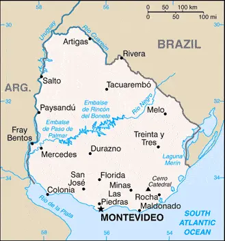
Driving Directions Uruguay

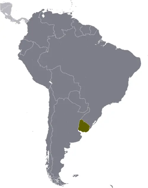
URUGUAY is one of the smallest countries in South America. It lies to the south of Brazil on the east coast of the continent and is bordered by the Uruguay River to the west, the waters of the Rio de la Plata to the south, and the Atlantic Ocean to the east. Uruguay consists of low plains and plateaux.

In the southeast, the grass-covered, rolling hills rise to 500 meters or 1,641 feet. There is a plateau with hills rising to 377 meters or 1,237 feet in the northwest and the second area of higher ground along the Atlantic coast with a maximum elevation of 501 meters or 1,645 feet.

Read more

Montevideo Google maps

Montevideo is one of the most populated cities in Uruguay, and at the same time, this city is the capital of this country. Located in America, you may find the city easily with the following GPS coordinates: 34.50S latitude / 56.11W longitude. For routing in Montevideo, please check the free driving directions Montevideo service below.

Read more

Uruguay Google Map

This image shows the draft map of Uruguay, South America. For more details of the map of Uruguay, please see this page below. This image shows the location of Uruguay, South America. For more geographical details of Uruguay, please see this page below. This image shows the flag of Uruguay, South America. For more details of the flag of Uruguay, please see this page below.
Borderline map of Uruguay Location map of Uruguay Flag of Uruguay

Uruguay Google map

Google maps and detailed facts of Uruguay (UY). This page enables you to explore Uruguay and its border countries (Country Location: Southern South America, bordering the South Atlantic Ocean, between Argentina and Brazil) through detailed Satellite imagery – fast and easy as never before Google maps.

Find comprehensive information below about this country in its diversity: Google maps, geography, economy, science, people, culture, environment, government, and history – All in One Wiki page.

There is also Street View and free Driving Directions at your service. Your Google Satellite Map Sightseeing in Uruguay, in South America, starts here at Driving Directions and Maps.com.

Read more