
 |
 |
 |
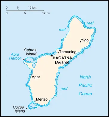
| Borderline map of Guam | Location map of Guam | Flag of Guam |
Google Maps and Detailed Facts of Guam (GU). This page lets you explore Guam and its border countries (Country Location: Oceania, an island in the North Pacific Ocean, about three-quarters of the way from Hawaii to the Philippines) through detailed Satellite imagery – fast and easy as never before Google Maps.
Find comprehensive information about this country’s diversity below: Google Maps, geography, economy, science, people, culture, environment, government, and history – All in One Wiki page.
There is also a Street View and free Driving Directions at your service. Your Google Satellite Map Sightseeing in Guam, in Oceania, starts here at Driving Directions and Maps.com.
Guam Google Maps & Satellite Maps
The map below shows Guam with its cities, towns, highways, main roads, streets, and Street Views. To find a location, use the form below, type any city or place, view a simple map, and click the “show map” button.
The Google Maps above shows Guam with its location: Oceania (geographic coordinates: 13 28 N, 144 47 E) and the international borders of Guam; 0 km; furthermore, it’s inland counties boundaries.
Hint: Look at the Street view in Guam or Oceania. All you have to do is drag and pull the little yellow man (named: Pegman) on the Google Maps above the desired location. After that, whenever it is available (more than 50 countries globally), blue stripes will appear to show the photos and details from Google’s regularly updated data image base. In case if you have signed in to your Google account currently, you may have a look at the satellite map of this country/area as well.
The map of Guam, Oceania, is for informational use only. No representation is made or warrantied given any map or its content by Driving Directions and Maps site. The user assumes all risks of using this Guam Google Maps and facts/wiki.
About Guam in detail
Where is Guam?
Guam, in case, if you are looking on the map under the Coordinates 13 28 N 144 44 E otherwise in Oceania, in Oceania, an island in the North Pacific Ocean, about three-quarters of the way from Hawaii to the Philippines.
What is the capital city of Guam?
The capital city of Guam is Hagatna.
What is the time in Hagatna?
It is 15 hours ahead of Washington, D.C. during Standard Time; the timezone of Hagatna is UTC+10.
What is the Internet code for Guam?
The Top Level Domain (TLD) for Guam is: .gu
What is the size of Guam?
The territory of Guam is total: 544 sq km; land: 544 sq km, water: 0 sq km.
If we want to describe the size of Guam’s territory is three times the size of Washington, DC.
If we would like to walk around and discover Guam, we can cover 0 km.
What is the water coverage of Guam?
We have already mentioned what percentage of Guam is covered by water (see below), including a 125.5 km coastline.
What is the climate like in Guam?
Guam’s climate is tropical marine: generally warm and humid, moderated by northeast trade winds: the dry season (January to June), rainy season (July to December): little seasonal temperature variation.
Geographical data of Guam
Guam elevation; mean elevation: N/A, elevation extremes; lowest point: Pacific Ocean 0 m, highest point: Mount Lamlam 406 m.
Guam’s specific geographical details include volcanic origin, surrounded by coral reefs; relatively flat coralline limestone plateau (source of most freshwater), steep coastal cliffs, and narrow coastal plains the north, low hills in the center, mountains in the south.
Suppose we would like to describe the countries location from a different perspective. In that case, it is safe to say and easy to read from a map, Guam is the largest and southernmost island in the Mariana Islands archipelago, a strategic location in the western North Pacific Ocean.
Resources and land use of Guam
The country’s main mined products are aquatic wildlife (supporting tourism), fishing (largely undeveloped). The population partly uses the earlier highlighted land territory and partly left in its natural state: agricultural land: 33.4%; arable land 1.9%; permanent crops 16.7%; permanent pasture 14.8%; forest: 47.9%; other: 18.7% (2011 estimate).
Population data of Guam
The number of inhabitants of Guam is 162,742 (July 2016 estimate).
If we examine the proportion of the population distribution, it is safe to say that N/A.
If we look at the proportion of the urbanized and barely populated areas, these are the urban population: 94.5% of the total population (2015).
Most of the population in Guam is concentrated in HAGATNA (capital) 143,000 (2014).
Ethnicity in Guam
According to ethnicity details, the ethnic groups are Chamorro 37.3%, Filipino 26.3%, white 7.1%, Chuukese 7%, Korean 2.2%, other Pacific Islander 2%, other Asian 2%, Chinese 1.6%, Palauan 1.6%, Japanese 1.5%, Pohnpeian 1.4%, mixed 9.4%, other 0.6% (2010 estimate).
Spoken languages in Guam
Guam’s spoken languages are the following: English 43.6%, Filipino 21.2%, Chamorro 17.8%, other Pacific island languages 10%, Asian languages 6.3%, other 1.1% (2010 estimate).
What are the most important religions in Guam?
According to this, during the general census, researchers examine the churches: Roman Catholic 85%, other 15% (1999 estimate).
Further population data of Guam
The proportion of gender and age tells a lot about the society as follows 0-14 years: 24.95% (male 20,881 / female 19,723) 15-24 years: 17.09% (male 14,445 / female 13,375) 25-54 years: 39.09% (male 32,335 / female 31,277) 55-64 years: 9.62% (male 7,912 / female 7,742) 65 years and over: 9.25% (male 6,847 / female 8,205) (2016 estimate). It also a significant factor in a society the population growth rate, which in the case of Guam is 0.64% (2016 estimate).
The population growth rate is based on two elements, the birth, and the death rate. In Guam the birth rate is 16.7 births / 1,000 population (2016 estimate), the death rate 5.2 deaths / 1,000 population (2016 estimate).
In this day and age in developed societies, the first child borns later compared to the previous centuries and decades, so childbearing is extended. In Guam, the average age of mothers at the first childbirth is N/A.
Although the children’s birth is postponed in the best-case scenario, the parents can still see their kids grow as life expectancy also extended. In the case of Guam, these figures are. With the introduction of modern medicine, vaccinations, and the proper hygienic conditions, the infant mortality rate is in a steep decline. The infant mortality statistics in Guam are the following: N/A. Relevant data is the budget of healthcare, which is in the case of this country is N/A.
Economic data of Guam
Suppose we would like to describe a country. We also have to mention its economy; US national defense spending is the main driver of Guam’s economy, followed by tourism and other services. Total federal spending (defense and non-defense) amounted to $1.973 billion in 2014 or 40.4% of GDP. Service exports, mainly spending by foreign to.
GDP is a prominent figure, as all the relevant calculations and statistics are based on it. GDP in Guam is $4.6 billion (2010 estimate).
Another important indicator is the rate of GDP growth, which in Guam is 0.6% (2013 estimate) 1.8% (2012)-0.3% (2011).
These statistics affect the world economy; remember, in 2015, the Chinese real GDP growth rate was worse than expected; The world markets fall, and the Chinese stock exchange was temporally suspended.
A further major factor of a country’s economy, the GDP per capita. In Guam this is $30,500 (2013 estimate) $29,800 (2012 estimate) $28,600 (2011 estimate).
In the economy, the Trinity is in common places, such as agriculture, industry, and services.
What are the agricultural products Guam produces?
Guam’s main agricultural products are fruits, copra, vegetables, eggs, pork, poultry, and beef.
The essential segments are national defense, tourism, construction, transshipment services, concrete products, printing and publishing, food processing, and textiles. The crucial and regularly mentioned GDP is based on national defense, tourism, construction, transshipment services, concrete products, printing and publishing, food processing, textiles.
Drinking water source in Guam
It is essential to mention that – thanks to the development of the infrastructure -, the rate of potable water improved: urban: 99.5% of the population, rural: 99.5% of the population, total: 99.5% of the population. Unimproved: urban: 0.5% of the population, rural: 0.5% of the population, total: 0.5% of the population (2015 estimate).
The average number of childbirth in Guam
In Guam, the average delivery number is 2.31 children born / woman (2016 estimate).
Population, median age, migration, and citizenship in Guam
The population’s average age is 30.4 years; male: 29.8 years, female: 30.9 years (2016 estimate). The age of adulthood varies in every country of the world in Guam; it is 18 years of age, universal.
When we are experiencing an unprecedented scale of migration and globalization, it is an important factor in the number of new immigrants. In Guam is -5.1 migrant(s) / 1,000 population (2016 estimate). It is important to know how to apply for citizenship: see the United States.
Is Guam a safe destination? Healthcare services and infectious diseases in Guam
Many of the travelers are looking into the healthcare services and infectious diseases of their destinations. In Guam, the hospital beds’ density is N/A.
According to the WHO rating regarding contagious diseases in Guam: N/A.
However, HIV is not curable but maintainable. Let’s do not forget when the disease surfaced; it was a world threatening condition. Unfortunately, in some countries, it is still very high the number of infected patients and fatalities due to the disease.
In Guam, the number of HIV/AIDS deaths: N/A.
Regarding tourism obesity, not an important issue, but we have to mention health statistics, as it is the plague of the 20th and the 21st century. The rate of obese adults in Guam is N/A.
What are the natural hazards in Guam? Is there any?
Guam’s most known natural risk is frequent squalls during the rainy season; relatively rare but potentially destructive typhoons (June to December).
More interesting facts about Guam
Like every country and society, a few words about the past are connected to its history; Spain ceded Guam to the US in 1898. Captured by the Japanese in 1941, it was retaken by the US three years later. The military installations on the island are some of the most strategically important US bases in the Pacific.
In every nation’s memory, some cornerstones placed the country on the timeline of history. The date of declaration of independence of Guam: none (territory of the US).
The flag and other symbols of Guam
The colors, symbols, and animals on the flag usually have a historical background or an important milestone or memory of the nation.
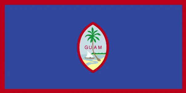
This case is not an exception either; the territorial flag is dark blue with a narrow red border on all four sides; centered is a red-bordered, pointed, vertical ellipse containing a beach scene, a proa or outrigger canoe with sail, and a palm tree with the word GUAM superimposed in bold red letters; the proa is sailing in Agana Bay with the promontory of Punta Dos Amantes, near the capital, in the background; the shape of the central emblem is that of a Chamorro sling stone, used as a weapon for defense or hunting; blue represents the sea and red the bloodshed in the struggle against oppression. Note: the US flag is the national flag.
Apart from the flag, the symbol of national unity is the national anthem. The anthem’s primary purpose is to share the nation’s core values, endeavors, and patriotic feelings.
National symbols of Guam: coconut tree; national colors: deep blue, red.
Constitution of Guam
The existence of the nation is based on the constitution. Some constitutions knew worldwide, like the U.S. Constitution that was accepted on the 17th of September 1787, in Philadelphia, the United States of America’s Constitution.
It is not related to the declaration of independence that was stolen by Nicolas Cage in the movie National Treasure 🙂
What is the legal system of Guam?
Most of the time, the legal system of a country is the focus of lawyers. It is a common fact that there are two main approaches in the world, “the law in books” and “the law in action.”
In the Anglo-Saxon world, the practice is the “law in action,” while in the rest of the world, the law is based on Roman law, the “law in books.”
The legal system of Guam is common law modeled on the US system; US federal laws apply.
It was Aristotle who founded the Theory of 3 separations of powers. In his view, these are the council of public affairs, the magistrates, and the justice system. The age of enlightenment was the time when terminologies have defined the way we still use them. In most democratic countries, the three authorities separated from each other. In dictatorships, the rules usually interweaved in one hand.
About the legislative branch of Guam, we can highlight the following structures unicameral Legislature of Guam or Liheslaturan Guahan (15 seats; members elected in a single countrywide constituency by simple majority vote to serve 2-year terms).
About the unemployment rate, labor force, and poverty line in Guam
One of the major problems of the 21st-century economy is unemployment. Governments are struggling to maintain a low level of the unemployment rate. Still, as a result of automation, the cheap 3rd world labor, and the outsourcing of workflow, these attempts fail. In Guam, the labor force is 70,490 (2013 estimate). Please bear in mind that the population in Guam is total: 5.3 deaths / 1,000 live births; male: 5.7 deaths / 1,000 live births, female: 4.9 deaths / 1,000 live births (2016 estimate) – as we already mentioned above.
The rate of unemployment in Guam is 8.4% (2013 estimate).
Widely known that the gap between the rich and poor is widening on an enormous scale.
According to the 2017 shocking Oxfam report, the most affluent eight people’s fortune is equal to the wealth of the poorest half of the world’s population.
In Guam, the households’ income and consumption compared to the entire population: lowest 10%: N/A% highest 10%: N/A%.
Another widely used indicator is the so-called GINI index, which measures the inequalities of statistical dispersion, but is mainly used for measuring the sharing of income and fortune.
The GINI index was named after its founder Corrado Gini, an Italian economist. Gini index has grades between 0-1, but often it is used on a percentage basis. It is 0 if the examined criteria territorial distribution is equal. It is one of the criteria concentrated on the territory. In Guam, the GINI index is N/A.
The states usually set up a poverty line, which is more or less, is a subjective measure. It varies by country; its base is often the minimum pension, the incomes of the most deficient 20 percent, the X percent of income per capita Etc.
In Guam, the poverty line people are the lowest 10%: N/A% highest 10%: N/A%.
About the budget and central governments debt of Guam
The available budget mainly defines the state’s economy. Guam’s budget is; revenues: $1.147 billion, expenditures: $1.188 billion (2013 estimate). Taxes and other revenues are 24.9% of GDP (2013 estimate).
The budget deficit (Budget surplus (+) or deficit (-)) is N/A.
The fiscal year in Guam is 1 October – 30 September.
In the country’s economy, we have to consider the public debt. Public debt is the consolidated sum of the state’s local, federal, and central government debt.
Inflation rate and prime lending rate in Guam
A few further interesting and relevant economic data are the following; Inflation rate: 1.8% (2014 estimate), 4% (2011 estimate), and the commercial bank prime lending rate: N/A.
Export/import partners and data of Guam
Guam, with the export of products, industrial tools, and other services, generates revenue. Guam’s export value is: $828 million (2013 estimate), $795 million (2012). The total revenue of these activities: transshipments of refined petroleum products, construction materials, fish, foodstuffs, and beverages.
The most important export partners of Guam are N/A.
The most important imported products are petroleum and petroleum products, food, manufactured goods, and the countries from where the import is coming: N/A.
Renewable energies used in Guam
To suppress the pollution of the environment, renewable energies have to replace the fossil energy. The more the proportion of renewable energies in a country means more effort against pollution. Guam, the indicator of how much of the country’s produced energy is coming from the hydroelectric source, is 0% of total installed capacity (2012 estimate).
To indicate how much another renewable energy produced is 0% of total installed capacity (2012 estimate).
Telecommunication data of Guam, calling code
To maintain the economy, the development of a reliable and modern telecommunications infrastructure is crucial. We can say the following about Guam; modern system, integrated with US facilities for direct dialing, including free use of 800 numbers. Domestic: digital system, including mobile-cellular service and local access to the Internet. International: country code – 1-671; central landing point for submarine cables between Asia and the US (Guam is a transpacific communications hub for major carriers linking the US and Asia); satellite earth stations – 2 Intelsat (Pacific Ocean) (2015).
Transport infrastructure in Guam
In the 21st century, we often say that the world has become small and there are no distances anymore. With widespread air travel when (sometimes) there are no visa restrictions, it is easy to reach other countries, but if the distance is not too long, we can also use railway or water transportation.
The number of airports in Guam: 5 (2013), and the number of heliports: N/A.
The total length of the roadways in Guam: total: 1,045 km (2008).
The total length of the waterways in Guam: N/A.
Are you traveling to Guam?
If you plan to travel by plane to Guam, try our air ticket comparison site, where you can choose from hundreds of carriers and offers. Our application is scanning the market and shows you the best and the cheapest deals without any extra charge or commission.
Are you looking for a hotel, apartment another kind of accommodation in Guam, Oceania? We are here to help you to find your accommodation from budget to luxury. Our search engine is scanning, regularly updating data from hundreds of accommodation websites and more than a million offers. You can quickly and easily find your hotel stay anywhere in the world, without any extra charge or commission.
Facts & data about Guam
Name of the country: conventional long way: Territory of Guam, traditional short form: Guam, local long form: Guahan, local short state: Guahan, etymology: the native Chamorro name for the island “Guahan” (meaning “we have” or “ours”) was changed to Guam in the 1898 Treaty of Paris whereby Spain relinquished Guam, Cuba, Puerto Rico, and the Philippines to the US.
| Abbreviation: Guam | Geographic coordinates: 13 28 N, 144 47 E |
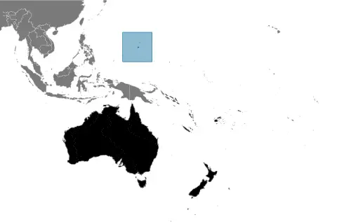
Country Location: Oceania |
| Capital of Guam: Hagatna | GPS of the Capital: 13 28 N 144 44 E |
Position: Oceania, an island in the North Pacific Ocean, about three-quarters of the way from Hawaii to the Philippines |
| Land area: total: 544 sq km; land: 544 sq km, water: 0 sq km | Terrain: volcanic origin, surrounded by coral reefs; relatively flat coralline limestone plateau (source of most freshwater), with steep coastal cliffs and narrow coastal plains in the north, low hills in the center, mountains in the south |
Area comparative: three times the size of Washington, DC |
| Population: 162,742 (July 2016 estimate) | Population grow rate: 0.64% (2016 estimate) | Sex ratio: at birth: 1.06 male(s) / female, 0-14 years: 1.06 male(s) / female, 15-24 years: 1.08 male(s) / female, 25-54 years: 1.03 male(s) / female, 55-64 years: 1.02 male(s) / female, 65 years and over: 0.84 male(s) / female, total population: 1.03 male(s) / female (2016 estimate) |
| Exports: $828 million (2013 estimate), $795 million (2012) | Imports: $2.501 billion (2013 estimate), $2.438 billion (2012) | Import partners: N/A |
| Urbanization: urban population: 94.5% of the total population (2015) | Major urban area(s): HAGATNA (capital) 143,000 (2014) | Median age: total: 30.4 years; male: 29.8 years, female: 30.9 years (2016 estimate) |
| Internet users: total: 118,000. Percent of the population: 73.1% (July 2015 estimate) | Telephones (fixed-lines): total subscriptions: 68,000. Subscriptions per 100 inhabitants: 42 (July 2015 estimate) | Telephones (mobile, cellular): total: 181,000. Subscriptions per 100 inhabitants: 113 (July 2015 estimate) |
| Unemployment rate: 8.4% (2013 estimate) | Nationality: Guamanian(s) (US citizens) adjective: Guamanian | National holidays: Discovery Day (or Magellan Day), first Monday in March (1521) |
| Life expectancy at birth: total population: 79.1 years. Male: 76.1 years, female: 82.4 years (2016 estimate) | Total fertility rate: 2.31 children born / woman (2016 estimate) | Birthrate: 16.7 births / 1,000 population (2016 estimate) |
| Literacy: N/A | Legal system: common law modeled on the US system; US federal laws apply | Suffrage: 18 years of age, universal |
| Industries: national defense, tourism, construction, transshipment services, concrete products, printing and publishing, food processing, textiles | Industrial production growth rate: N/A % | GDP real growth rate: 0.6% (2013 estimate) 1.8% (2012)-0.3% (2011) |
Do you like this Guam Google Maps & country information page?
Please do us a favor: Share or like this page using the icons at the top of the page. We also do encourage you to visit our Facebook page for more travel and country related information.
Many thanks for visiting and sharing this map & country information site!